
RRC operator 365175
Haskit, Kendall
Haskit, Kendall reported 643 barrels of oil and 2,568 mcf of gas in the last 12 months.
Operator dossier
- Producing leases
- 7of 10 on record
- Counties
- 2
- Biggest county
- Callahan County
- Biggest field
- Callahan County Regular
Get checks from Haskit, Kendall?
A family member owned minerals here?
Search their name: a family member who owned minerals hereWhere they work
fewermore
- Gas, last 12 months
- 2,568 mcf
- Fields
- 2
- Data through
- Aug 2026
- Leases on record
- 10
Where Haskit, Kendall has wells
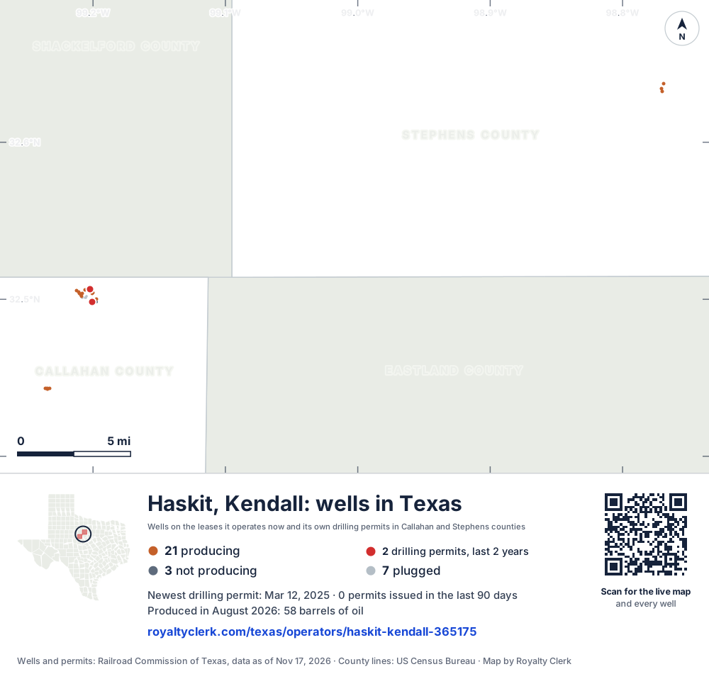
- Drilling locations2Permits issued in the last two years
- Producing wells21On a lease reporting production now
- Not producing3Shut in, inactive or no lease on record
- Plugged7The state's wellbore record says plugged
Each dot is a well on a lease Haskit, Kendall operates now, where the Railroad Commission's map puts it, or one of its drilling permits of the last 24 months. Wells of other operators are not on this map. The picture is about 31 miles across. The white counties are the ones with a well or drilling permit of its own on the map. Four more wells have no location on the state's map. Sources: Railroad Commission of Texas well layers and drilling permit files, US Census Bureau county outlines.
Use this map on your site
You may show this map on any site, unchanged. Keep the credit line and its link to Royalty Clerk under the map. The picture updates by itself as the state records new wells and permits.
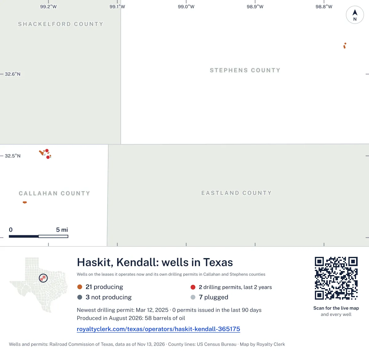
<a href="https://royaltyclerk.com/texas/operators/haskit-kendall-365175"><img src="https://royaltyclerk.com/maps/operator-wells/haskit-kendall-365175.svg" alt="Map of the wells of Haskit, Kendall in Texas: 31 wells and 2 recent drilling locations, in a picture about 31 miles across." width="1000" height="951" loading="lazy" style="max-width:100%;height:auto;border:0"></a>
<p style="margin:4px 0 0;font-size:14px">Map: <a href="https://royaltyclerk.com/texas/operators/haskit-kendall-365175">Oil and gas wells of Haskit, Kendall in Texas</a> by Royalty Clerk, from Railroad Commission of Texas records</p>
How Haskit, Kendall's output turned from oil to gas in 2022
Haskit, Kendall reported only oil in 2020 and 2021. In 2022 its output turned from oil to gas, the same year it took over six leases from other operators. Since then gas has made more of its output than oil in every full calendar year except 2025, when oil made more.
Its gas goes to a plant. The state records show 100.0% of its gas in the last 12 months went to a plant. It has 7 producing leases out of 10 on record, and 29 of its 38 wells are active. None of its wells is horizontal.
It still files new permits. It filed one in 2024 and two in 2025. Its leases are in Callahan and Stephens counties.
Not a forecast, not reserves.
Key moments
- 2022Took over six leases; output turned from oil to gas.
- 2023Gas reached 13,895 mcf, the largest gas year shown on this page.
- 2024Oil rose to 797 bbl; gas still made more of its output.
- 2025Oil made more of its output than gas, the only year since 2022.
- 2026Took over one more lease from another operator.
If you own here
- Who buys my oil and gas?
Colt G & P (North Texas) L.P. is the main buyer on one of its leases. This tool lists the buyers and since when.
- Old company, new payor
It handed leases to Dark Canyon Resources LLC and Clausen, A. G. This tool follows who carries on each name.
- Gas royalty calculator
100.0% of its gas went to a plant. This tool shows how plant and residue gas costs are counted.
Questions owners ask
- Who has run its leases, and since when?
- In the last 24 months it took over one lease from Clausen, A. G. It handed one lease to Clausen, A. G. and one lease to Dark Canyon Resources LLC. Old company, new payor
- Where does its gas go?
- The state records show 100.0% of its gas in the last 12 months went to a plant. The plant share is on the page's gas disposition figures. Gas royalty calculator
- Which counties does it produce in?
- Callahan County and Stephens County. Callahan holds 97.4% of its oil. Stephens holds 100.0% of its gas.
Related pages
- Post, S. H.
Its oldest producing lease, with reports back to January 1993.
- Callahan County
Callahan County holds 97.4% of its oil.
- Stephens County
Stephens County holds 100.0% of its gas.
- Callahan County Regular
Its six producing leases in Callahan are in this field.
- Stephens County Regular
Its one producing lease in Stephens is in this field.
From the state's records through July 2026.
Its oil and gas by month over the last five years
Oil output from Haskit, Kendall fell 6% over the last 12 months
643 bbl through Aug 2026, against 682 bbl a year earlier. Peak Apr 2024: 98 bbl.
Gas output from Haskit, Kendall fell 47% over the last 12 months
2,568 mcf through Aug 2026, against 4,861 mcf a year earlier. Peak Nov 2022: 3,909 mcf.
SourceTexas Railroad Commission Production Data Query, operator 365175, through Aug 2026, file dated Oct 20, 2026.
Its 10 leases, biggest first, and which ones produce now
Under each volume: change on the year before.
320bbl oil−19%
142bbl oil−1%
104bbl oil+160%
48bbl oiln/a
43bbl oiln/a
18bbl oil−70%
10bbl oil+400%
Showing 7 of 7.
SourceTexas Railroad Commission Production Data Query.
Callahan and Stephens counties where it produces
Counties, by Haskit, Kendall oil
Callahan County leads
Fields, by Haskit, Kendall oil
Callahan County Regular leads
Drilling permits it filed in 2024 and 2025
WYLIE A #K 9
new drill · Haskit, Kendall · Callahan County
Permit 0906515 · Mar 12, 2025
WYLIE L #K 8
new drill · Haskit, Kendall · Callahan County
Permit 0904987 · Jan 10, 2025
WILLIAMS, R. D. #10
new drill · Haskit, Kendall · Callahan County
Permit 0903534 · Nov 4, 2024
Where the gas of Haskit, Kendall went
- Plants
- 100%
- Pipelines
- 0.0%
- Lease fuel
- 0.0%
- Flared or vented
- 0.0%
SourceTexas Railroad Commission Production Data Query, last 12 months. What the codes mean