
Morris County, Texas
Oil wells and drilling locations near Lone Star
- 126wells
- 16drilling locations in two years
- 88producing leases
Within 10 miles
Wells and drilling locations around Lone Star
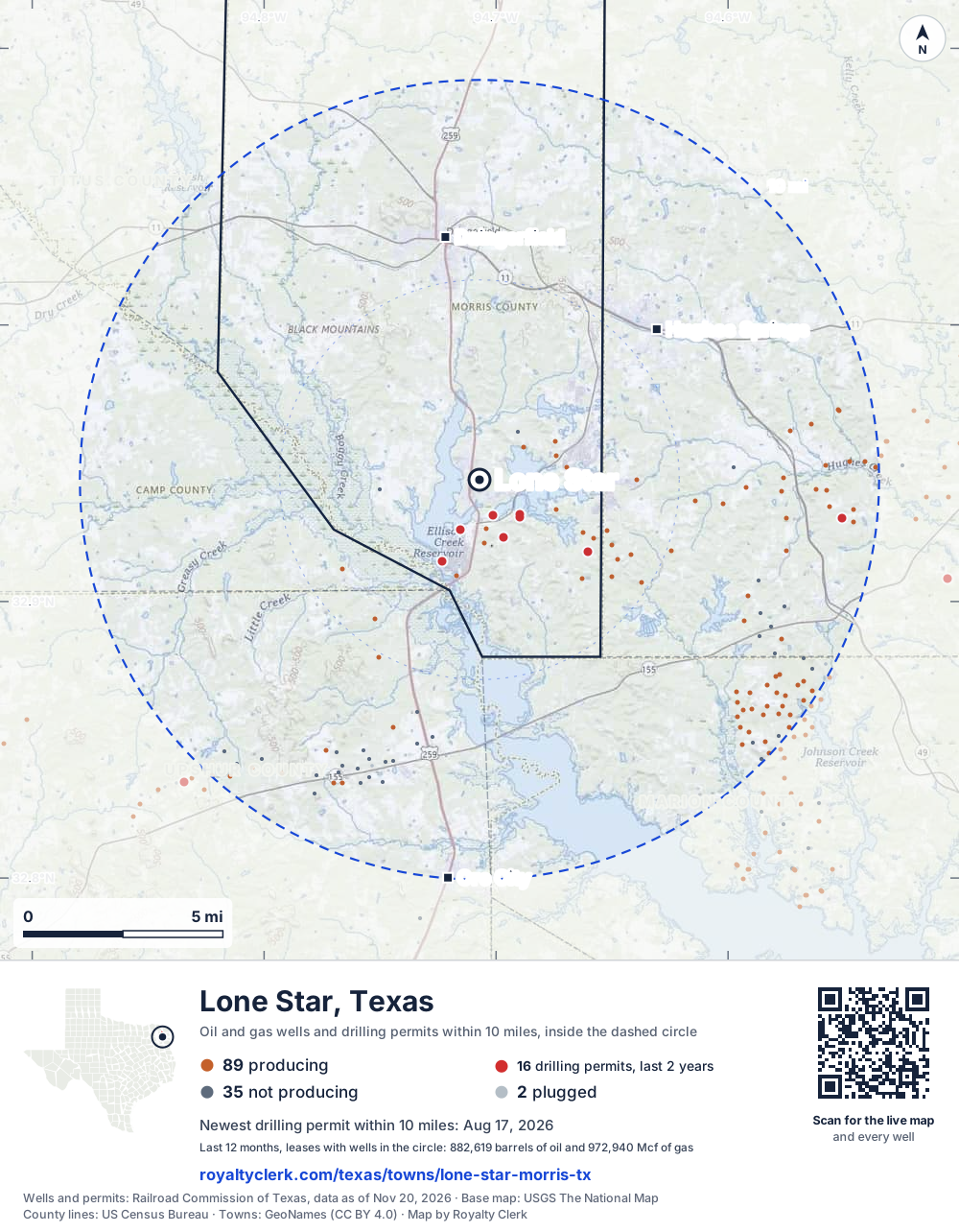
- Drilling locations16Permits issued in the last two years
- Producing wells89On a lease reporting production now
- Not producing35Shut in, inactive or no lease on record
- Plugged2The state's wellbore record says plugged
The dashed circle is 10 miles from the town's point (32.94402, -94.70715); the counts are for wells inside it. Sources: Railroad Commission of Texas well layers and permit files, US Census Bureau county outlines, town points from GeoNames (CC BY 4.0), base map from USGS The National Map.
Use this map on your site
You may show this map on any site, unchanged. Keep the credit line and its link to Royalty Clerk under the map. The picture updates by itself as the state records new wells and permits.
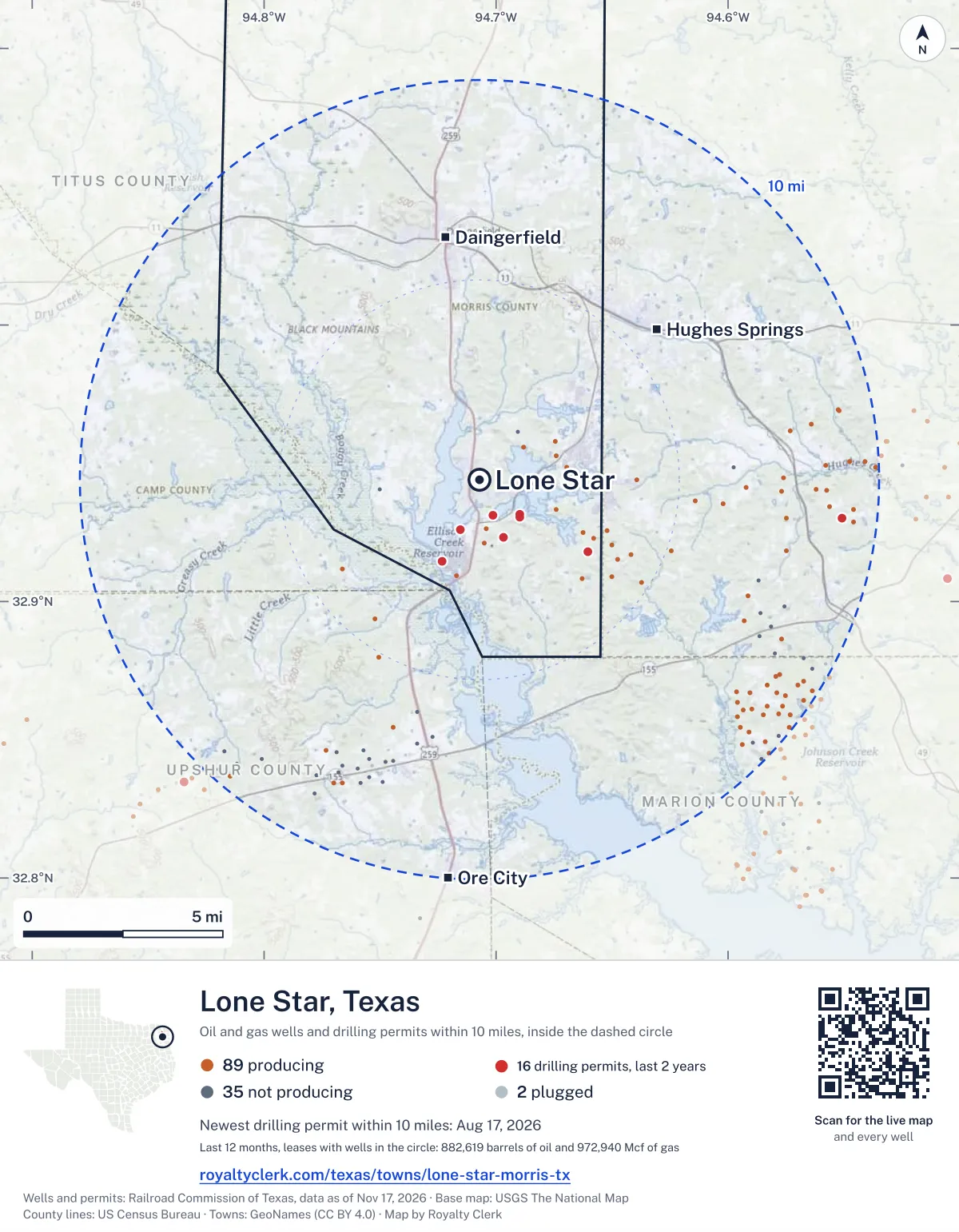
<a href="https://royaltyclerk.com/texas/towns/lone-star-morris-tx"><img src="https://royaltyclerk.com/maps/town-wells/lone-star-morris-tx.svg" alt="Map of Lone Star, Texas: 126 wells and 16 recent drilling locations within 10 miles, inside a dashed circle." width="1000" height="1284" loading="lazy" style="max-width:100%;height:auto;border:0"></a>
<p style="margin:4px 0 0;font-size:14px">Map: <a href="https://royaltyclerk.com/texas/towns/lone-star-morris-tx">Lone Star, Texas oil and gas wells</a> by Royalty Clerk, from Railroad Commission of Texas records</p>
Which way it is heading
Where the new drilling is around Lone Star
What became of the 16 permits
- 3finished, on a lease that reports productionThe well was completed and its lease is reporting oil or gas to the state.
- 4drilling startedThe operator reported a start date. No completion is on file yet.
- 9still only a permitNothing after the permit is on file. Many permits wait a year or more, and some are never drilled.
Wells finished in the last two years: 5 south-east of town.
A permit is permission to drill, not a well, and a well nearby says nothing about who owns the minerals under it. Direction is taken from the well's surface location. Source: Railroad Commission of Texas drilling permits and wellbore records.
In numbers
Oil and gas within 10 miles of Lone Star
- wells with a location on the state's map
- 126
- drilling permits in the last 24 months
- 16
- producing leases with a well in the circle
- 88
- operators running them
- 5
- oil and condensate those leases reported in their latest 12 months
- 882,619 bbl
- gas those leases reported in their latest 12 months
- 972,940 mcf
A lease counts when at least one of its wells is inside the circle; its whole production is counted, so a lease reaching beyond the circle counts in full.
In dollars
What the oil and gas near Lone Star sold for
- sale value of 12 months, before taxes and costs
- $68 million
- oil and condensate sold
- 882,651 bbl
- gas sold
- 373,137 mcf
- the middle lease: half sold more, half less
- $159,762
A 0.01 share (1%) of the middle producing lease near Lone Star comes to about $1,598 for the 12 months.
Sold volumes at the public monthly prices, before severance tax and any costs. A guide to the size, not what any owner was paid.
Sold volumes from each lease's monthly report to the Railroad Commission, times the month's West Texas Intermediate oil price and Henry Hub gas price (EIA). Real prices at the lease differ. A lease counts in full when one of its wells is near the town. Check a statement against what the lease sold
Drilling locations
The newest drilling permits near Lone Star
| Issued | Lease and well | Where | Operator |
|---|---|---|---|
| 2026-08-17 | EL CORTEZ 1Hhorizontal · API 42-343-30142 · permit 0916906Rose City Resources, LLC | 2.2 mi SW32.91460, -94.72314 on OpenStreetMap (opens in a new tab) | Rose City Resources, LLC |
| 2026-07-07 | HARRAHS 1Hhorizontal · API 42-343-30140 · permit 0915886Rose City Resources, LLC | 2.2 mi SW32.91455, -94.72314 on OpenStreetMap (opens in a new tab) | Rose City Resources, LLC |
| 2026-07-01 | COSMOPOLITAN 1Hhorizontal · API 42-343-30141 · permit 0915887Rose City Resources, LLC | 3.2 mi SE32.91804, -94.66062 on OpenStreetMap (opens in a new tab) | Rose City Resources, LLC |
| 2026-05-27 | EXCALIBUR 1Hhorizontal · API 42-343-30139 · permit 0914490Rose City Resources, LLC | 3.2 mi SE32.91799, -94.66062 on OpenStreetMap (opens in a new tab) | Rose City Resources, LLC |
| 2026-05-05 | PALAZZO 1Hhorizontal · API 42-343-30135 · permit 0910794Rose City Resources, LLC | 1.6 mi SE32.92319, -94.69668 on OpenStreetMap (opens in a new tab) | Rose City Resources, LLC |
| 2026-02-23 | BALLYS 1Hhorizontal · API 42-343-30138 · permit 0913553Rose City Resources, LLC | 2.2 mi SW32.91449, -94.72315 on OpenStreetMap (opens in a new tab) | Rose City Resources, LLC |
| 2026-01-21 | VENETIAN 1Hhorizontal · API 42-343-30137 · permit 0912285Rose City Resources, LLC | 1.6 mi SE32.92324, -94.69671 on OpenStreetMap (opens in a new tab) | Rose City Resources, LLC |
| 2025-12-16 | HOLLYWOOD 1Hhorizontal · API 42-343-30136 · permit 0911341Rose City Resources, LLC | 1.3 mi S32.92597, -94.71561 on OpenStreetMap (opens in a new tab) | Rose City Resources, LLC |
| 2025-05-21 | SILVER SEVENS 1Hhorizontal · API 42-343-30133 · permit 0907612Rose City Resources, LLC | 1.4 mi SE32.93055, -94.68984 on OpenStreetMap (opens in a new tab) | Rose City Resources, LLC |
| 2025-05-07 | MCD 1vertical · API 42-067-30881 · permit 0907796Barrow-Shaver Resources Co. | 9.1 mi E32.93027, -94.55089 on OpenStreetMap (opens in a new tab) | Barrow-Shaver Resources Co. |
| 2025-04-29 | WESTGATE 1Hhorizontal · API 42-343-30134 · permit 0907611Rose City Resources, LLC | 1.4 mi SE32.93059, -94.68992 on OpenStreetMap (opens in a new tab) | Rose City Resources, LLC |
| 2025-02-05 | ENCORE 1Hhorizontal · API 42-343-30127 · permit 0901623Rose City Resources, LLC | 0.9 mi S32.93126, -94.70137 on OpenStreetMap (opens in a new tab) | Rose City Resources, LLC |
| 2025-01-15 | MGM 1Hhorizontal · API 42-343-30126 · permit 0901156Rose City Resources, LLC | 0.9 mi S32.93126, -94.70130 on OpenStreetMap (opens in a new tab) | Rose City Resources, LLC |
| 2024-12-18 | LUXOR 1Hhorizontal · API 42-343-30132 · permit 0904693Rose City Resources, LLC | 1.3 mi SE32.93148, -94.68992 on OpenStreetMap (opens in a new tab) | Rose City Resources, LLC |
| 2024-12-12 | SAHARA 1Hhorizontal · API 42-343-30131 · permit 0904483Rose City Resources, LLC | 1.3 mi SE32.93143, -94.68985 on OpenStreetMap (opens in a new tab) | Rose City Resources, LLC |
| 2024-11-25 | TUSCANY 1Hhorizontal · API 42-343-30130 · permit 0904186Rose City Resources, LLC | 1.3 mi S32.92593, -94.71558 on OpenStreetMap (opens in a new tab) | Rose City Resources, LLC |
| 2024-09-13 | IMPERIAL 1Hhorizontal · API 42-343-30128 · permit 0902037Rose City Resources, LLC | 2.9 mi SE32.92501, -94.66264 on OpenStreetMap (opens in a new tab) | Rose City Resources, LLC |
| 2024-08-20 | MANDALAY 1Hhorizontal · API 42-343-30129 · permit 0902038Rose City Resources, LLC | 2.9 mi SE32.92506, -94.66261 on OpenStreetMap (opens in a new tab) | Rose City Resources, LLC |
| 2024-07-31 | DINSMORE 1vertical · API 42-063-30351 · permit 0901693Rose City Resources, LLC | 4.1 mi SW32.91176, -94.76637 on OpenStreetMap (opens in a new tab) | Rose City Resources, LLC |
| 2024-05-30 | WHITE 1vertical · API 42-343-30125 · permit 0900036Barrow-Shaver Resources Co. | 2.7 mi NW32.96217, -94.74860 on OpenStreetMap (opens in a new tab) | Barrow-Shaver Resources Co. |
| 2024-04-23 | STOERMER SWD 1vertical · API 42-067-30944 · permit 0899073Barrow-Shaver Resources Co. | 4.6 mi E32.94596, -94.62745 on OpenStreetMap (opens in a new tab) | Barrow-Shaver Resources Co. |
| 2024-04-16 | TEMPLETON 1vertical · API 42-067-30941 · permit 0898782Barrow-Shaver Resources Co. | 9.7 mi E32.95070, -94.54113 on OpenStreetMap (opens in a new tab) | Barrow-Shaver Resources Co. |
| 2024-03-28 | FLORENCE 1Hhorizontal · API 42-067-30937 · permit 0898234Rose City Resources, LLC | 5.4 mi E32.93650, -94.61399 on OpenStreetMap (opens in a new tab) | Rose City Resources, LLC |
| 2024-03-22 | ROACH 1vertical · API 42-063-30350 · permit 0898316Rose City Resources, LLC | 5.0 mi SW32.91450, -94.78587 on OpenStreetMap (opens in a new tab) | Rose City Resources, LLC |
| 2024-03-20 | OTEY 1vertical · API 42-067-30938 · permit 0898292Barrow-Shaver Resources Co. | 6.0 mi E32.91687, -94.60820 on OpenStreetMap (opens in a new tab) | Barrow-Shaver Resources Co. |
A permit is permission to drill, not a well. Distances are from the town's point to the well's surface location. Source: Railroad Commission of Texas drilling permits.
Find your land
The surveys under the new drilling near Lone Star
- A-253 SMITH, E B5 permits, newest August 17, 2026
- A-89 DALBY, J B4 permits, newest May 21, 2025
- A-412 KING, W2 permits, newest July 1, 2026
- A-390 DALBY, A, section 332 permits, newest May 5, 2026
- A-263 SKINNER, L2 permits, newest February 5, 2025
- A-223 CANNON, J1 permit, newest May 7, 2025
Not in the list? Search every survey in the county by name or abstract number.
Who is on the county roll
What the county mineral roll lists near Lone Star
- mineral accounts on the roll
- 229
- owner names
- 166
- appraised value of those accounts
- $54 million
- the middle account's appraised value
- $5,780
- the middle account in all of Morris County
- $27,500
Totals from the county appraisal district's mineral roll, matched to leases by the state lease number. No owner is named here, and a count under 10 accounts or 5 owner names is left out. How Morris County values minerals, and how to protest · Inherited minerals: where to start
Producing leases
Top producing leases near Lone Star
- 1Silver Sevens119,553 bbl · 68,106 mcf a yearRose City Resources, LLC · Morris County · 1 well in the circle
- 2Sahara107,986 bbl · 57,290 mcf a yearRose City Resources, LLC · Morris County · 1 well in the circle
- 3Luxor86,184 bbl · 23,052 mcf a yearRose City Resources, LLC · Morris County · 1 well in the circle
- 4Wynn71,174 bbl · 31,230 mcf a yearRose City Resources, LLC · Morris County · 1 well in the circle
- 5Mandalay57,055 bbl · 25,601 mcf a yearRose City Resources, LLC · Morris County · 1 well in the circle
- 6Horseshoe56,413 bbl · 23,612 mcf a yearRose City Resources, LLC · Morris County · 1 well in the circle
- 7Bellagio54,952 bbl · 29,260 mcf a yearRose City Resources, LLC · Morris County · 1 well in the circle
- 8Imperial49,417 bbl · 24,527 mcf a yearRose City Resources, LLC · Morris County · 1 well in the circle
- 9Florence31,849 bbl · 31,099 mcf a yearRose City Resources, LLC · Cass County · 1 well in the circle
- 10Aria28,448 bbl · 18,010 mcf a yearRose City Resources, LLC · Morris County · 1 well in the circle
- 11Ayers-Keasler (Aw)19,819 bbl · 68,423 mcf a yearBarrow-Shaver Resources Co. · Cass County · 1 well in the circle
- 12Palms20,937 bbl · 5,268 mcf a yearRose City Resources, LLC · Cass County · 1 well in the circle
- 13Wilmeth-Wren (Aw)11,793 bbl · 24,110 mcf a yearBarrow-Shaver Resources Co. · Cass County · 1 well in the circle
- 14McCaslin-Hall2 bbl · 85,309 mcf a yearBuffco Production Inc. · Upshur County · 1 well in the circle
- 15Dunes10,168 bbl · 21,712 mcf a yearRose City Resources, LLC · Morris County · 1 well in the circle
- 16Rio11,577 bbl · 5,350 mcf a yearRose City Resources, LLC · Morris County · 1 well in the circle
- 17Ashley11,543 bbl · 0 mcf a yearRose City Resources, LLC · Cass County · 1 well in the circle
- 18Circus Circus9,006 bbl · 9,864 mcf a yearRose City Resources, LLC · Morris County · 1 well in the circle
- 19El Dorado9,736 bbl · 0 mcf a yearRose City Resources, LLC · Cass County · 1 well in the circle
- 20Grubbs4,917 bbl · 22,761 mcf a yearBarrow-Shaver Resources Co. · Cass County · 1 well in the circle
Whose name is on the check
Who buys the oil and gas near Lone Star
Oil and condensate
- DK TRADING & SUPPLY, LLC74 leases
- EASTEX CRUDE COMPANY, LLC16 leases
- ENERGY TRANSFER MARKETING & TERM1 lease
Gas
- MIDCOAST PIPELINES (E TX) L.P.25 leases
- HIDDEN ROCK MIDSTREAM, LLC16 leases
- SULPHUR RIVER GATHERING LLC7 leases
- MIDCOAST G & P (EAST TEXAS) L.P.2 leases
From each lease's newest Form P-4 filing with the Railroad Commission, which names its gatherers and purchasers. One lease can name several.
If your checks stopped
Leases near Lone Star that went quiet or changed hands
4 leases reported nothing for a year or more
Leases that reported within the last four years and then stopped. The newest to stop first.
- Hogg Heirs Gu #1 · Oily Dog Operators Texas, LLClast report March 2025
- Lacy Heirs Gu 1 · Oily Dog Operators Texas, LLClast report March 2025
- Cedar Springs Gas Unit 3 · Buffco Production Inc.last report November 2022
- Cedar Springs Gas Unit #3 · Buffco Production Inc.last report November 2022
1 lease got a new operator in two years
Checks often pause after a change while the new company sets up its owner records. The newest first.
- Lone Star SteelBurk Royalty Co., Ltd. to Rose City Resources, LLCDecember 2024
From the monthly production reports operators file with the Railroad Commission. The newest months fill in late, so a lease is listed only after 12 months with no report.
Year by year
Production of the leases near Lone Star, by year
| Year | Oil, bbl | Gas, mcf |
|---|---|---|
| 2026 so far | 548,957 | 652,446 |
| 2025 | 1,058,554 | 980,710 |
| 2024 | 1,033,910 | 1,281,574 |
| 2023 | 777,621 | 1,099,710 |
| 2022 | 264,204 | 648,465 |
| 2021 | 79,211 | 526,025 |
| 2020 | 51,237 | 613,835 |
Every lease with a well in the circle, producing now or not, as reported to the Railroad Commission. The newest months fill in as operators report.
The long view: in the state's records from January 1993 on, 75 of these leases reported 1,085,848 bbl of oil and condensate and 56,801,899 mcf of gas. Each lease page carries that lease's history back to January 1993.
Good to know
The wells near Lone Star, and what a lease has gone for
- depth of the middle well on file
- 11,800 ft
- the deepest on file
- 13,000 ft
Depth and well type from the Railroad Commission's well records, where the record has them. State lease figures from the Texas General Land Office.
Around it
Towns near Lone Star
- Hughes Springs5.8 mi NE107 wells · 17 permits
- Daingerfield6.1 mi N37 wells · 15 permits
- Ore City9.9 mi S297 wells · 23 permits
- Pittsburg15 mi W193 wells · 0 permits
- Naples18 mi N0 wells · 1 permits
- Gilmer20 mi SW604 wells · 8 permits
- Linden20 mi E147 wells · 22 permits
- Mount Pleasant21 mi NW0 wells · 2 permits
- Jefferson25 mi SE447 wells · 12 permits
Lone Star is in ZIP code 75668: its wells and permits
All of Morris County: leases, operators and production · Morris County well map
Press and community kit
Writing about Lone Star? Take what you need
Three facts to quote
- 126 oil and gas wells on the state's map lie within 10 miles of Lone Star: 89 on producing leases, 35 not producing and 2 plugged.
- The Railroad Commission of Texas issued 8 drilling permits within 10 miles of Lone Star in the last 12 months, the newest dated August 17, 2026.
- The 88 producing leases with a well in that circle, run by 5 operators, reported 882,619 barrels of oil and 972,940 thousand cubic feet of gas over their latest 12 months.
The map picture
The page's map with its legend and credit, as a JPEG.


The live map on your page
A frame that loads its picture first and the live map on a tap. No cookies.
How to cite
Railroad Commission of Texas records of the wells and drilling permits within 10 miles of Lone Star, mapped by Royalty Clerk (https://royaltyclerk.com/texas/towns/lone-star-morris-tx), data as of November 19, 2026.
Under a map or a chart: Source: Railroad Commission of Texas · Map: Royalty Clerk, with a link to this page.
The figures say where the state's records put wells and permits, not who owns the land or the minerals. Kits for other Texas towns
Follow it
Watch the 10 miles around Lone Star
Watching a place says nothing about who owns the land or the minerals there. For the whole county, or one survey, use the Morris County well watch.
FAQ
Questions people ask
How many oil and gas wells are near Lone Star?
126 wells with a location on the Railroad Commission's map lie within 10 miles of Lone Star: 89 on leases that are producing, 35 not producing and 2 plugged. The state also issued 16 drilling permits with a well location in that circle in the last 24 months.
What are the coordinates on this page?
Latitude and longitude of the well's surface location in NAD83, the coordinates map apps use. They come from the Railroad Commission's well layers as published, and from its drilling permit files, which are published in the older NAD27 and converted here. Paste them into any map app. A horizontal well's bottom hole can be a mile or two away from its surface location.
Do I own minerals under a well near Lone Star?
A well nearby says nothing about who owns the minerals under it. The county's mineral roll lists who is paid on each producing lease. Search a name to see whether the Morris County roll lists it.
Is drilling near Lone Star picking up or slowing down?
Drilling permits near Lone Star are holding steady: 8 permits in the last 12 months, 8 in the 12 months before. Most of them are south of town: 15 of 16 lie on that side. The nearest is under a mile south of the town's point. A permit is permission to drill, not a well.
How much are the oil and gas near Lone Star worth?
The 88 producing leases with a well within 10 miles sold about $68 million of oil and gas in their newest 12 months on file, at the public monthly prices and before taxes and costs. That is what the leases sold, not what a tract of land or a mineral interest is worth: an owner is paid a share of one lease.
My checks from a lease here stopped. Why?
The usual reasons: the lease stopped producing, a new operator took it over, or the operator put the payments in suspense over a title or address question. Near Lone Star, 4 leases went quiet and 1 changed operator; both lists are on this page.
Own land or minerals near Lone Star?
See whether a county roll lists your name, and get an email when a permit or a new well is filed near you.
Sources
Primary sources, opened on 29 September 2026. Statute text is the current version on statutes.capitol.texas.gov.