
Midland County, Texas
Oil wells and drilling locations near Midland
- 4,854wells
- 504drilling locations in two years
- 1,274producing leases
Within 10 miles
Wells and drilling locations around Midland
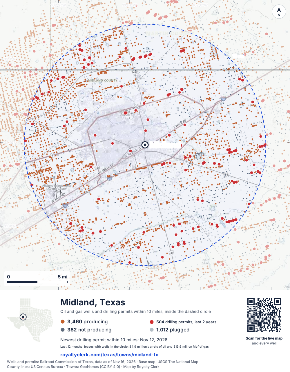
- Drilling locations504Permits issued in the last two years
- Producing wells3,462On a lease reporting production now
- Not producing383Shut in, inactive or no lease on record
- Plugged1,009The state's wellbore record says plugged
The dashed circle is 10 miles from the town's point (31.99735, -102.07791); the counts are for wells inside it. Sources: Railroad Commission of Texas well layers and permit files, US Census Bureau county outlines, town points from GeoNames (CC BY 4.0), base map from USGS The National Map.
Use this map on your site
You may show this map on any site, unchanged. Keep the credit line and its link to Royalty Clerk under the map. The picture updates by itself as the state records new wells and permits.
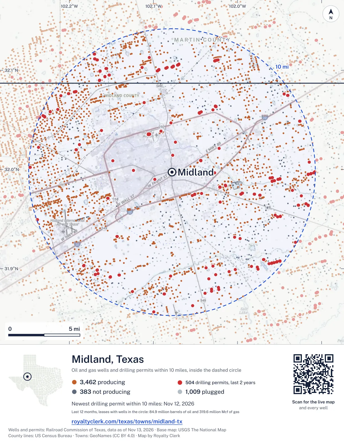
<a href="https://royaltyclerk.com/texas/towns/midland-tx"><img src="https://royaltyclerk.com/maps/town-wells/midland-tx.svg" alt="Map of Midland, Texas: 4,854 wells and 504 recent drilling locations within 10 miles, inside a dashed circle." width="1000" height="1284" loading="lazy" style="max-width:100%;height:auto;border:0"></a>
<p style="margin:4px 0 0;font-size:14px">Map: <a href="https://royaltyclerk.com/texas/towns/midland-tx">Midland, Texas oil and gas wells</a> by Royalty Clerk, from Railroad Commission of Texas records</p>
Which way it is heading
Where the new drilling is around Midland
What became of the 504 permits
- 171finished, on a lease that reports productionThe well was completed and its lease is reporting oil or gas to the state.
- 3finished, no production reported yetA completion is on file. The first production report follows weeks or months later.
- 171drilling startedThe operator reported a start date. No completion is on file yet.
- 159still only a permitNothing after the permit is on file. Many permits wait a year or more, and some are never drilled.
Wells finished in the last two years: 83 north, 45 north-east, 47 east, 55 south-east, 43 south, 33 south-west, 13 north-west of town.
A horizontal well runs sideways underground. 376 wells start outside the 10-mile circle and end inside it. 332 start inside and end outside. So a well can drain land a mile or two from the spot where it shows on a map.
A permit is permission to drill, not a well, and a well nearby says nothing about who owns the minerals under it. Direction is taken from the well's surface location. Source: Railroad Commission of Texas drilling permits and wellbore records.
When a new well starts paying
First checks coming due near Midland
- GBG Jupiter 27-15 Cwas due October 28, 2026
- Nail-Burley 6Jwas due October 28, 2026
- Nail-Burley 6Awas due October 28, 2026
- Nail-Burley 6Gwas due October 28, 2026
- Nail-Burley 6Ewas due October 28, 2026
- Nail-Burley 6Hwas due October 28, 2026
- Nail-Burley 6Iwas due October 28, 2026
- Nail-Burley 6Dwas due October 28, 2026
- GBG Jupiter 27-15 Bwas due October 28, 2026
- Nail-Burley 6Fwas due October 28, 2026
- Nail-Burley 6Kwas due October 28, 2026
- Nail -E- well 2was due October 28, 2026
The date is the earliest the law allows a first payment to be late (Texas Natural Resources Code 91.402), worked out from the first month of production on file. It is not a promise of a check: title questions and unsigned division orders can hold one back. Work out a first-check date · What to do before the first check
In numbers
Oil and gas within 10 miles of Midland
- wells with a location on the state's map
- 4,854
- drilling permits in the last 24 months
- 504
- producing leases with a well in the circle
- 1,274
- operators running them
- 37
- oil and condensate those leases reported in their latest 12 months
- 84,903,572 bbl
- gas those leases reported in their latest 12 months
- 319,604,808 mcf
A lease counts when at least one of its wells is inside the circle; its whole production is counted, so a lease reaching beyond the circle counts in full.
In dollars
What the oil and gas near Midland sold for
- sale value of 12 months, before taxes and costs
- $7.4 billion
- oil and condensate sold
- 83,665,948 bbl
- gas sold
- 306,407,879 mcf
- the middle lease: half sold more, half less
- $2.6 million
A 0.01 share (1%) of the middle producing lease near Midland comes to about $26,375 for the 12 months.
Sold volumes at the public monthly prices, before severance tax and any costs. A guide to the size, not what any owner was paid.
Sold volumes from each lease's monthly report to the Railroad Commission, times the month's West Texas Intermediate oil price and Henry Hub gas price (EIA). Real prices at the lease differ. A lease counts in full when one of its wells is near the town. Check a statement against what the lease sold
Drilling locations
The newest drilling permits near Midland
| Issued | Lease and well | Where | Operator |
|---|---|---|---|
| 2026-11-12 | KIMBERLY U 1WBhorizontal · API 42-317-47496 · permit 0918697Diamondback E&P LLC | 9.5 mi NW32.11148, -102.16962 on OpenStreetMap (opens in a new tab) | Diamondback E&P LLC |
| 2026-11-10 | HULK HOGAN 12-48 F 3JMhorizontal · API 42-329-48613 · permit 0919021Diamondback E&P LLC | 7.6 mi E31.99065, -101.94927 on OpenStreetMap (opens in a new tab) | Diamondback E&P LLC |
| 2026-11-10 | HULK HOGAN 12-48 E 3WBhorizontal · API 42-329-48611 · permit 0919018Diamondback E&P LLC | 7.6 mi E31.99060, -101.94951 on OpenStreetMap (opens in a new tab) | Diamondback E&P LLC |
| 2026-11-10 | HULK HOGAN 12-48 E 3LShorizontal · API 42-329-48612 · permit 0919020Diamondback E&P LLC | 7.6 mi E31.99062, -101.94943 on OpenStreetMap (opens in a new tab) | Diamondback E&P LLC |
| 2026-11-10 | HULK HOGAN 12-48 E 2MShorizontal · API 42-329-48610 · permit 0919015Diamondback E&P LLC | 7.6 mi E31.99063, -101.94935 on OpenStreetMap (opens in a new tab) | Diamondback E&P LLC |
| 2026-11-10 | HULK HOGAN 12-48 D 2WDhorizontal · API 42-329-48614 · permit 0919034Diamondback E&P LLC | 7.4 mi E31.99005, -101.95179 on OpenStreetMap (opens in a new tab) | Diamondback E&P LLC |
| 2026-11-10 | HULK HOGAN 12-48 D 2WAhorizontal · API 42-329-48608 · permit 0919004Diamondback E&P LLC | 7.5 mi E31.99056, -101.94966 on OpenStreetMap (opens in a new tab) | Diamondback E&P LLC |
| 2026-11-10 | HULK HOGAN 12-48 D 2JMhorizontal · API 42-329-48609 · permit 0919013Diamondback E&P LLC | 7.5 mi E31.99054, -101.94974 on OpenStreetMap (opens in a new tab) | Diamondback E&P LLC |
| 2026-11-10 | HULK HOGAN 12-38 C 2WBhorizontal · API 42-329-48607 · permit 0918999Diamondback E&P LLC | 7.5 mi E31.99058, -101.94958 on OpenStreetMap (opens in a new tab) | Diamondback E&P LLC |
| 2026-11-10 | HULK HOGAN 12-38 C 2LShorizontal · API 42-329-48606 · permit 0918998Diamondback E&P LLC | 7.4 mi E31.99011, -101.95156 on OpenStreetMap (opens in a new tab) | Diamondback E&P LLC |
| 2026-11-06 | KNIGHT 160 MIPA UNIT H160NWhorizontal · API 42-329-47363 · permit 0919924Permian Deep Rock Oil Co., LLC | 3.0 mi N32.03872, -102.09114 on OpenStreetMap (opens in a new tab) | Permian Deep Rock Oil Co., LLC |
| 2026-11-06 | KNIGHT 150 MIPA UNIT H150NBhorizontal · API 42-329-47362 · permit 0919921Permian Deep Rock Oil Co., LLC | 3.0 mi N32.03869, -102.09109 on OpenStreetMap (opens in a new tab) | Permian Deep Rock Oil Co., LLC |
| 2026-11-06 | KNIGHT 140 MIPA UNIT H140NWhorizontal · API 42-329-47361 · permit 0919923Permian Deep Rock Oil Co., LLC | 2.9 mi N32.03866, -102.09103 on OpenStreetMap (opens in a new tab) | Permian Deep Rock Oil Co., LLC |
| 2026-11-06 | KNIGHT 130 MIPA UNIT H130NBhorizontal · API 42-329-47360 · permit 0919920Permian Deep Rock Oil Co., LLC | 2.9 mi N32.03864, -102.09098 on OpenStreetMap (opens in a new tab) | Permian Deep Rock Oil Co., LLC |
| 2026-11-06 | KNIGHT 120 MIPA UNIT H120NWhorizontal · API 42-329-47359 · permit 0919922Permian Deep Rock Oil Co., LLC | 2.9 mi N32.03861, -102.09092 on OpenStreetMap (opens in a new tab) | Permian Deep Rock Oil Co., LLC |
| 2026-11-06 | KNIGHT 120 MIPA UNIT H120CFhorizontal · API 42-329-48666 · permit 0919918Permian Deep Rock Oil Co., LLC | 2.9 mi N32.03855, -102.09100 on OpenStreetMap (opens in a new tab) | Permian Deep Rock Oil Co., LLC |
| 2026-11-06 | KNIGHT 110 MIPA UNIT H110NBhorizontal · API 42-329-47357 · permit 0919919Permian Deep Rock Oil Co., LLC | 2.9 mi N32.03858, -102.09087 on OpenStreetMap (opens in a new tab) | Permian Deep Rock Oil Co., LLC |
| 2026-11-06 | KNIGHT 110 MIPA UNIT H110CFhorizontal · API 42-329-48665 · permit 0919917Permian Deep Rock Oil Co., LLC | 2.9 mi N32.03852, -102.09094 on OpenStreetMap (opens in a new tab) | Permian Deep Rock Oil Co., LLC |
| 2026-11-05 | HULK HOGAN 12-38 B 1WDhorizontal · API 42-329-48604 · permit 0918963Diamondback E&P LLC | 7.4 mi E31.99004, -101.95187 on OpenStreetMap (opens in a new tab) | Diamondback E&P LLC |
| 2026-11-05 | HULK HOGAN 12-38 B 1WAhorizontal · API 42-329-48603 · permit 0918956Diamondback E&P LLC | 7.4 mi E31.99007, -101.95171 on OpenStreetMap (opens in a new tab) | Diamondback E&P LLC |
| 2026-11-05 | HULK HOGAN 12-38 B 1JMhorizontal · API 42-329-48602 · permit 0918955Diamondback E&P LLC | 7.4 mi E31.99000, -101.95202 on OpenStreetMap (opens in a new tab) | Diamondback E&P LLC |
| 2026-11-04 | HULK HOGAN 12-38 A 1WBhorizontal · API 42-329-48601 · permit 0918954Diamondback E&P LLC | 7.4 mi E31.99002, -101.95194 on OpenStreetMap (opens in a new tab) | Diamondback E&P LLC |
| 2026-11-04 | KIMBERLY 20 A U 2WBhorizontal · API 42-317-47500 · permit 0918707Diamondback E&P LLC | 9.5 mi NW32.11146, -102.16969 on OpenStreetMap (opens in a new tab) | Diamondback E&P LLC |
| 2026-11-02 | KIMBERLY 3JMhorizontal · API 42-317-47498 · permit 0918704Diamondback E&P LLC | 9.4 mi NW32.11049, -102.16680 on OpenStreetMap (opens in a new tab) | Diamondback E&P LLC |
| 2026-10-29 | HULK HOGAN 12-38 C 1MShorizontal · API 42-329-48605 · permit 0918997Diamondback E&P LLC | 7.4 mi E31.99009, -101.95163 on OpenStreetMap (opens in a new tab) | Diamondback E&P LLC |
A permit is permission to drill, not a well. Distances are from the town's point to the well's surface location. Source: Railroad Commission of Texas drilling permits.
Find your land
The surveys under the new drilling near Midland
- A-646 DUNN, L O, block 39 T1N, section 3231 permits, newest June 30, 2026
- A-36 T&P RR CO, block 39 T1S, section 1529 permits, newest May 27, 2026
- A-159 T&P RR CO, block 38 T2S, section 1123 permits, newest December 3, 2025
- A-794 KING, J M, section 5122 permits, newest June 29, 2026
- A-165 T&P RR CO, block 38 T2S, section 3322 permits, newest March 9, 2026
- A-671 BRECKON, W M, block 38 T1S, section 622 permits, newest April 25, 2025
- A-314 T&P RR CO, block 39 T1S, section 122 permits, newest April 23, 2025
- A-265 T&P RR CO, block 40 T2S, section 2721 permits, newest April 4, 2025
Not in the list? Search every survey in the county by name or abstract number.
Who is on the county roll
695 mineral accounts near Midland are still in the name of an estate
- mineral accounts on the roll
- 112,330
- owner names
- 13,937
- appraised value of those accounts
- $9.1 billion
- the middle account's appraised value
- $1,940
- the middle account in all of Midland County
- $630
- accounts titled to an estate
- 695
An account in the name of an estate usually means the owner died and the title was never moved to the heirs. The account stays on the roll, and these are appraised at $17 million together. If a parent or grandparent owned minerals near Midland, their name may be one of them.
Counted the other way: 321,703 royalty-interest records on Texas county mineral rolls (rolls of 2024 to 2026) carry Midland as their mailing city, wherever in Texas the minerals lie. See the count for every city
Totals from the county appraisal district's mineral roll, matched to leases by the state lease number. No owner is named here, and a count under 10 accounts or 5 owner names is left out. How Midland County values minerals, and how to protest · Inherited minerals: where to start
Producing leases
Top producing leases near Midland
- 1South Curtis Ranch2,764,549 bbl · 8,775,685 mcf a yearOccidental Permian Ltd. · Martin County · 232 wells in the circle
- 2Soa Scharbauer Se1,703,949 bbl · 6,597,020 mcf a yearChevron U. S. A. Inc. · Midland County · 103 wells in the circle
- 3Texas Ten Y Pu1,155,344 bbl · 9,643,561 mcf a yearPioneer Natural Res. USA, Inc. · Midland County · 107 wells in the circle
- 4Stone Cold 11-2 Unit 21,442,546 bbl · 3,754,029 mcf a yearDiamondback E&P LLC · Midland County · 16 wells in the circle
- 5South Curtis Ranch1,001,621 bbl · 4,535,573 mcf a yearOccidental Permian Ltd. · Martin County · 13 wells in the circle
- 6Nobles933,332 bbl · 3,330,334 mcf a yearXTO Energy Inc. · Midland County · 104 wells in the circle
- 7Kimberly1,150,769 bbl · 1,564,705 mcf a yearDiamondback E&P LLC · Martin County · 50 wells in the circle
- 8Mbe1,049,630 bbl · 1,337,150 mcf a yearFirebird Energy II LLC · Midland County · 8 wells in the circle
- 9GBG Reedy 13/25 Unit420,393 bbl · 4,106,015 mcf a yearChevron U. S. A. Inc. · Midland County · 17 wells in the circle
- 10Lela 18-6 E846,234 bbl · 1,463,882 mcf a yearDiamondback E&P LLC · Midland County · 4 wells in the circle
- 11Bulldog757,683 bbl · 1,950,826 mcf a yearPermian Deep Rock Oil Co., LLC · Midland County · 14 wells in the circle
- 12Lela 18-6 H812,430 bbl · 1,312,949 mcf a yearDiamondback E&P LLC · Midland County · 5 wells in the circle
- 13Hill 30-19433,808 bbl · 3,421,384 mcf a yearDiamondback E&P LLC · Midland County · 17 wells in the circle
- 14MCC HZ Unit830,274 bbl · 1,015,597 mcf a yearCog Operating LLC · Midland County · 25 wells in the circle
- 15Scharbauer, C.550,514 bbl · 2,632,906 mcf a yearChevron U. S. A. Inc. · Midland County · 120 wells in the circle
- 16MB687,495 bbl · 1,668,338 mcf a yearFirebird Energy II LLC · Midland County · 12 wells in the circle
- 17Gridiron385,488 bbl · 3,430,297 mcf a yearDiamondback E&P LLC · Midland County · 32 wells in the circle
- 18Mask HZ Unit782,569 bbl · 856,237 mcf a yearCog Operating LLC · Midland County · 22 wells in the circle
- 19Elkins-Atrelle 31-42586,940 bbl · 1,943,642 mcf a yearDiamondback E&P LLC · Midland County · 13 wells in the circle
- 20St313,037 bbl · 3,568,365 mcf a yearDiamondback E&P LLC · Midland County · 124 wells in the circle
Whose name is on the check
Who buys the oil and gas near Midland
Oil and condensate
- MEDALLION OPERATING COMPANY, LLC294 leases
- ENERGY TRANS CRUDE MARKETING LLC277 leases
- ENTERPRISE CRUDE OIL LLC198 leases
- ENERGY TRANSFER COMPANY190 leases
- ENERGY TRANSFER MARKETING & TERM109 leases
Gas
- TARGA PL MID-CONT WESTTEX LLC608 leases
- ONEOK MIDLAND MIDSTREAM, LLC139 leases
- ENTERPRISE M B MIDSTREAM LLC85 leases
- ET GATHERING & PROCESSING LLC80 leases
- PHILLIPS 66 DOS PICOS LLC79 leases
From each lease's newest Form P-4 filing with the Railroad Commission, which names its gatherers and purchasers. One lease can name several.
If your checks stopped
Leases near Midland that went quiet or changed hands
136 leases reported nothing for a year or more
Leases that reported within the last four years and then stopped. The newest to stop first; 10 shown.
- Baker "A" · Pioneer Natural Res. USA, Inc.last report August 2025
- Nail-P '2A' · Oxyrock Operating, LLClast report August 2025
- Easy Target 3097OP · Occidental Permian Ltd.last report August 2025
- Betty "12" · Pioneer Natural Res. USA, Inc.last report July 2025
- Simms · Pioneer Natural Res. USA, Inc.last report July 2025
- Nail -B- · Pioneer Natural Res. USA, Inc.last report July 2025
- Casbeer · Pioneer Natural Res. USA, Inc.last report July 2025
- Baumann -B- · Pioneer Natural Res. USA, Inc.last report July 2025
- Butler -22- · Diamondback E&P LLClast report July 2025
- Lela · Diamondback E&P LLClast report June 2025
168 leases got a new operator in two years
Checks often pause after a change while the new company sets up its owner records. The newest first; 10 shown.
- Caza ElkinsBasin Oil & Gas Operating, LLC to GL Energy Operating LLCMay 2026
- 8 Mile FVital Energy, Inc. to Crescent Energy Operating, LLCMarch 2026
- 8 Mile AVital Energy, Inc. to Crescent Energy Operating, LLCJanuary 2026
- 8 Mile CVital Energy, Inc. to Crescent Energy Operating, LLCJanuary 2026
- 8 Mile DVital Energy, Inc. to Crescent Energy Operating, LLCJanuary 2026
- 8 Mile EVital Energy, Inc. to Crescent Energy Operating, LLCJanuary 2026
- 8 Mile GVital Energy, Inc. to Crescent Energy Operating, LLCJanuary 2026
- 8 Mile HVital Energy, Inc. to Crescent Energy Operating, LLCJanuary 2026
- 8 Mile JVital Energy, Inc. to Crescent Energy Operating, LLCJanuary 2026
- 8 Mile KVital Energy, Inc. to Crescent Energy Operating, LLCJanuary 2026
From the monthly production reports operators file with the Railroad Commission. The newest months fill in late, so a lease is listed only after 12 months with no report.
Year by year
Production of the leases near Midland, by year
| Year | Oil, bbl | Gas, mcf |
|---|---|---|
| 2026 so far | 55,753,564 | 209,516,046 |
| 2025 | 87,892,210 | 314,209,764 |
| 2024 | 94,698,926 | 298,107,649 |
| 2023 | 86,806,321 | 260,740,235 |
| 2022 | 92,774,166 | 233,450,360 |
| 2021 | 76,771,843 | 187,931,485 |
| 2020 | 79,564,662 | 165,291,730 |
Every lease with a well in the circle, producing now or not, as reported to the Railroad Commission. The newest months fill in as operators report.
The long view: in the state's records from January 1993 on, 942 of these leases reported 318,806,474 bbl of oil and condensate and 655,486,116 mcf of gas. Each lease page carries that lease's history back to January 1993.
Good to know
The wells near Midland, and what a lease has gone for
For a lease offer: the State of Texas leased 54 of its own tracts in Midland County in the last ten years. The middle bonus was $1,250 an acre, the usual royalty 12.5%, the usual term 3 years; the newest is dated May 12, 2026. Private leases are not public, so these are the nearest figures on record. Is my lease offer fair in Midland County?
Depth and well type from the Railroad Commission's well records, where the record has them. State lease figures from the Texas General Land Office.
Around it
Towns near Midland
Press and community kit
Writing about Midland? Take what you need
Three facts to quote
- 4,854 oil and gas wells on the state's map lie within 10 miles of Midland: 3,462 on producing leases, 383 not producing and 1,009 plugged.
- The Railroad Commission of Texas issued 292 drilling permits within 10 miles of Midland in the last 12 months, the newest dated November 12, 2026.
- The 1,274 producing leases with a well in that circle, run by 37 operators, reported 84,903,572 barrels of oil and 319,604,808 thousand cubic feet of gas over their latest 12 months.
The map picture
The page's map with its legend and credit, as a JPEG.
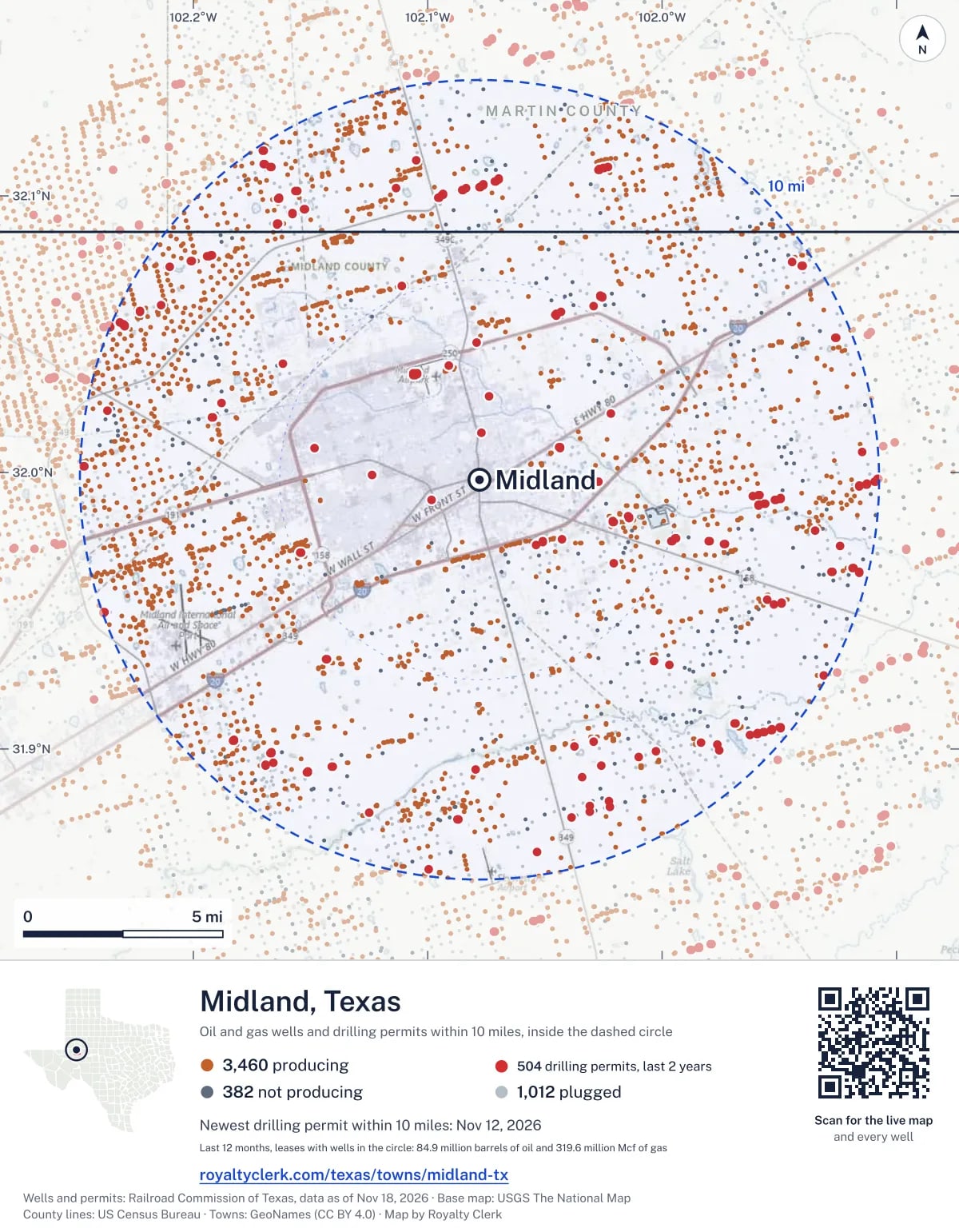

The live map on your page
A frame that loads its picture first and the live map on a tap. No cookies.
How to cite
Railroad Commission of Texas records of the wells and drilling permits within 10 miles of Midland, mapped by Royalty Clerk (https://royaltyclerk.com/texas/towns/midland-tx), data as of November 15, 2026.
Under a map or a chart: Source: Railroad Commission of Texas · Map: Royalty Clerk, with a link to this page.
The figures say where the state's records put wells and permits, not who owns the land or the minerals. Kits for other Texas towns
Follow it
Watch the 10 miles around Midland
Watching a place says nothing about who owns the land or the minerals there. For the whole county, or one survey, use the Midland County well watch.
FAQ
Questions people ask
How many oil and gas wells are near Midland?
4,854 wells with a location on the Railroad Commission's map lie within 10 miles of Midland: 3,462 on leases that are producing, 383 not producing and 1,009 plugged. The state also issued 504 drilling permits with a well location in that circle in the last 24 months.
What are the coordinates on this page?
Latitude and longitude of the well's surface location in NAD83, the coordinates map apps use. They come from the Railroad Commission's well layers as published, and from its drilling permit files, which are published in the older NAD27 and converted here. Paste them into any map app. A horizontal well's bottom hole can be a mile or two away from its surface location.
Do I own minerals under a well near Midland?
A well nearby says nothing about who owns the minerals under it. The county's mineral roll lists who is paid on each producing lease. Search a name to see whether the Midland County roll lists it.
Is drilling near Midland picking up or slowing down?
Drilling permits near Midland are rising: 292 permits in the last 12 months, 212 in the 12 months before. Most of them are north-east of town: 240 of 504 lie on that side. The nearest is 1.2 miles north of the town's point. A permit is permission to drill, not a well.
When does a new well near Midland start paying royalties?
Texas law gives the payor 120 days after the end of the month of first sale to send the first payment (Natural Resources Code 91.402). The date is the earliest a first payment becomes late, not a promise: a title question or an unsigned division order can hold a check back.
How much are the oil and gas near Midland worth?
The 1,274 producing leases with a well within 10 miles sold about $7.4 billion of oil and gas in their newest 12 months on file, at the public monthly prices and before taxes and costs. That is what the leases sold, not what a tract of land or a mineral interest is worth: an owner is paid a share of one lease.
A relative owned minerals near Midland and has died. What now?
The county mineral roll still lists 695 accounts in the name of an estate on leases near Midland. Search the family name first. If an account turns up, the title usually has to be moved to the heirs before the operator will pay them.
My checks from a lease here stopped. Why?
The usual reasons: the lease stopped producing, a new operator took it over, or the operator put the payments in suspense over a title or address question. Near Midland, 136 leases went quiet and 168 changed operator; both lists are on this page.
Own land or minerals near Midland?
695 accounts near Midland are still in the name of an estate. See whether a county roll lists your name, and get an email when a permit or a new well is filed near you.
Sources
Primary sources, opened on 29 September 2026. Statute text is the current version on statutes.capitol.texas.gov.