
Hale County, Texas
Oil wells and drilling locations near Petersburg
- 3wells
- 0drilling locations in two years
- 1producing lease
Within 10 miles
Wells and drilling locations around Petersburg

- Drilling locations0Permits issued in the last two years
- Producing wells1On a lease reporting production now
- Not producing2Shut in, inactive or no lease on record
- Plugged0The state's wellbore record says plugged
The dashed circle is 10 miles from the town's point (33.86952, -101.59739); the counts are for wells inside it. Sources: Railroad Commission of Texas well layers and permit files, US Census Bureau county outlines, town points from GeoNames (CC BY 4.0), base map from USGS The National Map.
Use this map on your site
You may show this map on any site, unchanged. Keep the credit line and its link to Royalty Clerk under the map. The picture updates by itself as the state records new wells and permits.
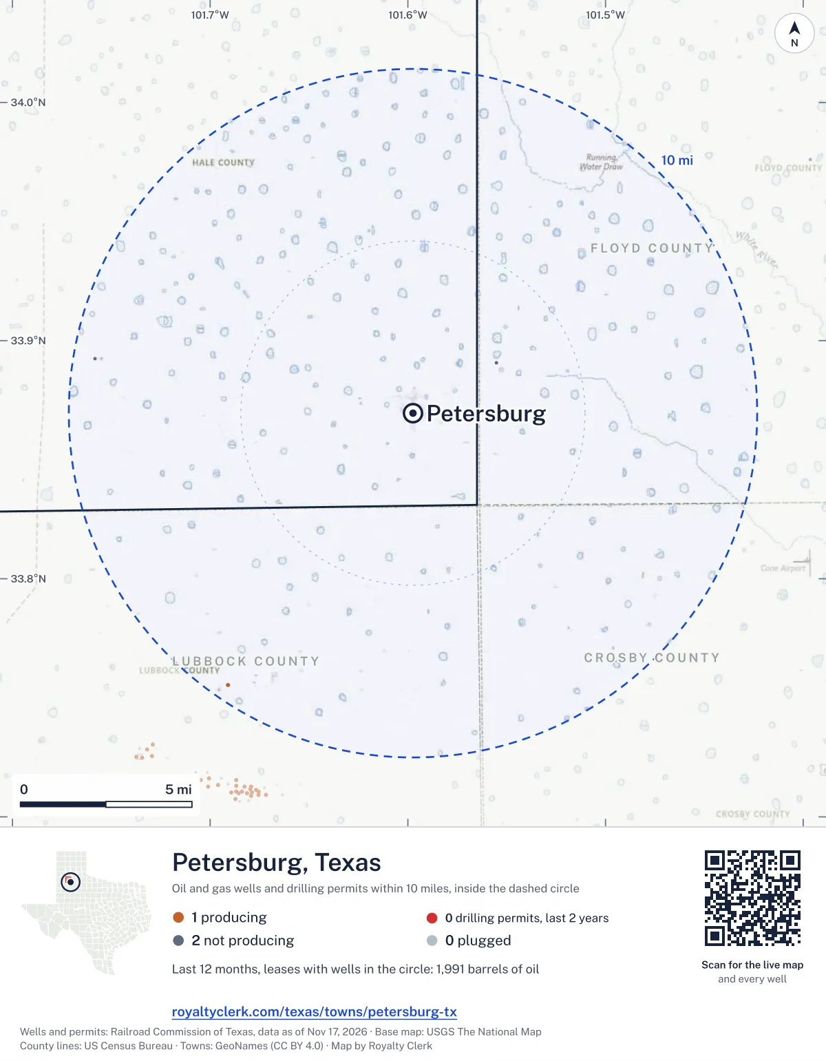
<a href="https://royaltyclerk.com/texas/towns/petersburg-tx"><img src="https://royaltyclerk.com/maps/town-wells/petersburg-tx.svg" alt="Map of Petersburg, Texas: 3 wells and 0 recent drilling locations within 10 miles, inside a dashed circle." width="1000" height="1284" loading="lazy" style="max-width:100%;height:auto;border:0"></a>
<p style="margin:4px 0 0;font-size:14px">Map: <a href="https://royaltyclerk.com/texas/towns/petersburg-tx">Petersburg, Texas oil and gas wells</a> by Royalty Clerk, from Railroad Commission of Texas records</p>
In numbers
Oil and gas within 10 miles of Petersburg
- wells with a location on the state's map
- 3
- drilling permits in the last 24 months
- 0
- producing leases with a well in the circle
- 1
- operator running them
- 1
- oil and condensate those leases reported in their latest 12 months
- 1,991 bbl
- gas those leases reported in their latest 12 months
- 0 mcf
A lease counts when at least one of its wells is inside the circle; its whole production is counted, so a lease reaching beyond the circle counts in full.
In dollars
What the oil and gas near Petersburg sold for
- sale value of 12 months, before taxes and costs
- $144,671
- oil and condensate sold
- 2,016 bbl
- gas sold
- 0 mcf
- the middle lease: half sold more, half less
- $144,671
A 0.01 share (1%) of the middle producing lease near Petersburg comes to about $1,447 for the 12 months.
Sold volumes at the public monthly prices, before severance tax and any costs. A guide to the size, not what any owner was paid.
Sold volumes from each lease's monthly report to the Railroad Commission, times the month's West Texas Intermediate oil price and Henry Hub gas price (EIA). Real prices at the lease differ. A lease counts in full when one of its wells is near the town. Check a statement against what the lease sold
Who is on the county roll
What the county mineral roll lists near Petersburg
- mineral accounts on the roll
- 21
- owner names
- 18
- appraised value of those accounts
- $439,480
- the middle account's appraised value
- $2,980
Totals from the county appraisal district's mineral roll, matched to leases by the state lease number. No owner is named here, and a count under 10 accounts or 5 owner names is left out. How Hale County values minerals, and how to protest · Inherited minerals: where to start
Producing leases
Top producing leases near Petersburg
- 1Collier1,991 bbl · 0 mcf a yearMcDonald Production, LLC · Lubbock County · 1 well in the circle
Whose name is on the check
Who buys the oil and gas near Petersburg
Oil and condensate
- MISSION PETROLEUM CARRIERS, INC.1 lease
From each lease's newest Form P-4 filing with the Railroad Commission, which names its gatherers and purchasers. One lease can name several.
Year by year
Production of the leases near Petersburg, by year
| Year | Oil, bbl | Gas, mcf |
|---|---|---|
| 2026 so far | 1,162 | 0 |
| 2025 | 2,510 | 0 |
| 2024 | 2,562 | 0 |
| 2023 | 2,640 | 0 |
| 2022 | 2,609 | 0 |
| 2021 | 3,448 | 0 |
| 2020 | 2,774 | 0 |
Every lease with a well in the circle, producing now or not, as reported to the Railroad Commission. The newest months fill in as operators report.
The long view: in the state's records from January 1993 on, 3 of these leases reported 115,414 bbl of oil and condensate and 792 mcf of gas. Each lease page carries that lease's history back to January 1993.
Around it
Towns near Petersburg
- Lorenzo14 mi S137 wells · 0 permits
- Abernathy14 mi W117 wells · 0 permits
- Idalou15 mi S364 wells · 0 permits
- Floydada17 mi NE1 wells · 0 permits
- Ralls18 mi SE0 wells · 0 permits
- Hale Center20 mi NW0 wells · 0 permits
- Lockney20 mi NE0 wells · 1 permits
- Plainview23 mi N1 wells · 1 permits
- Ransom Canyon24 mi S652 wells · 2 permits
- Seth Ward24 mi N1 wells · 1 permits
Petersburg is in ZIP code 79250: its wells and permits
All of Hale County: leases, operators and production · Hale County well map
Follow it
Watch the 10 miles around Petersburg
Watching a place says nothing about who owns the land or the minerals there. For the whole county, or one survey, use the Hale County well watch.
FAQ
Questions people ask
How many oil and gas wells are near Petersburg?
3 wells with a location on the Railroad Commission's map lie within 10 miles of Petersburg: 1 on leases that are producing, 2 not producing and 0 plugged. The state issued no drilling permit with a well location in that circle in the last 24 months.
What are the coordinates on this page?
Latitude and longitude of the well's surface location in NAD83, the coordinates map apps use. They come from the Railroad Commission's well layers as published, and from its drilling permit files, which are published in the older NAD27 and converted here. Paste them into any map app. A horizontal well's bottom hole can be a mile or two away from its surface location.
Do I own minerals under a well near Petersburg?
A well nearby says nothing about who owns the minerals under it. The county's mineral roll lists who is paid on each producing lease. Search a name to see whether the Hale County roll lists it.
Is drilling near Petersburg picking up or slowing down?
The state issued no drilling permit with a well location within 10 miles of Petersburg in the last two years. The nearest one is 22 miles north of town, issued November 2, 2026. A permit is permission to drill, not a well.
How much are the oil and gas near Petersburg worth?
The 1 producing leases with a well within 10 miles sold about $144,671 of oil and gas in their newest 12 months on file, at the public monthly prices and before taxes and costs. That is what the leases sold, not what a tract of land or a mineral interest is worth: an owner is paid a share of one lease.
My checks from a lease here stopped. Why?
The usual reasons: the lease stopped producing, a new operator took it over, or the operator put the payments in suspense over a title or address question.
Own land or minerals near Petersburg?
See whether a county roll lists your name, and get an email when a permit or a new well is filed near you.
Sources
Primary sources, opened on 29 September 2026. Statute text is the current version on statutes.capitol.texas.gov.