
Fayette County, Texas
Oil wells and drilling locations near Schulenburg
- 29wells
- 6drilling locations in two years
- 18producing leases
Within 10 miles
Wells and drilling locations around Schulenburg
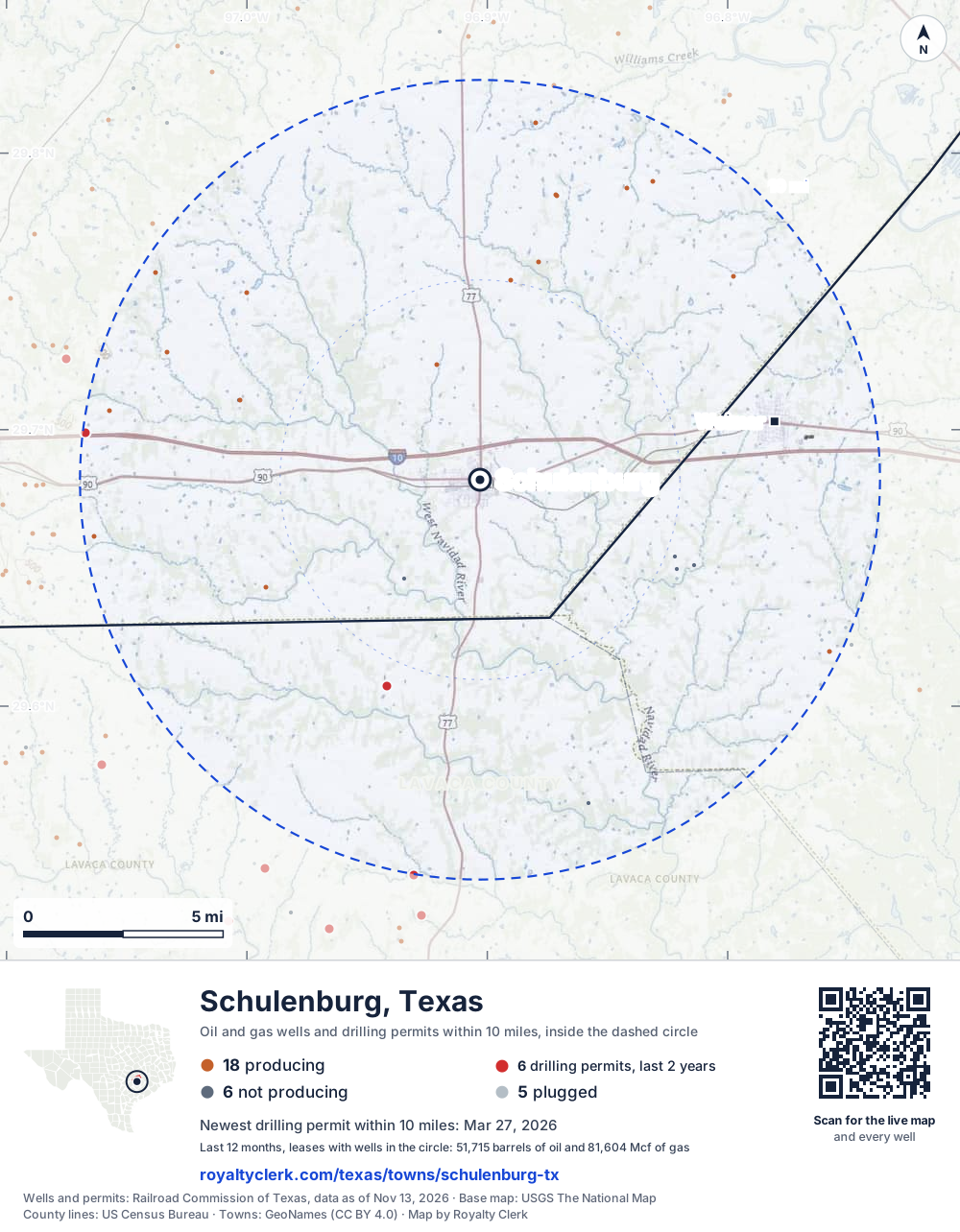
- Drilling locations6Permits issued in the last two years
- Producing wells18On a lease reporting production now
- Not producing6Shut in, inactive or no lease on record
- Plugged5The state's wellbore record says plugged
The dashed circle is 10 miles from the town's point (29.68190, -96.90304); the counts are for wells inside it. Sources: Railroad Commission of Texas well layers and permit files, US Census Bureau county outlines, town points from GeoNames (CC BY 4.0), base map from USGS The National Map.
Use this map on your site
You may show this map on any site, unchanged. Keep the credit line and its link to Royalty Clerk under the map. The picture updates by itself as the state records new wells and permits.
<a href="https://royaltyclerk.com/texas/towns/schulenburg-tx"><img src="https://royaltyclerk.com/maps/town-wells/schulenburg-tx.svg" alt="Map of Schulenburg, Texas: 29 wells and 6 recent drilling locations within 10 miles, inside a dashed circle." width="1000" height="1284" loading="lazy" style="max-width:100%;height:auto;border:0"></a>
<p style="margin:4px 0 0;font-size:14px">Map: <a href="https://royaltyclerk.com/texas/towns/schulenburg-tx">Schulenburg, Texas oil and gas wells</a> by Royalty Clerk, from Railroad Commission of Texas records</p>
Which way it is heading
Where the new drilling is around Schulenburg
What became of the 6 permits
- 4drilling startedThe operator reported a start date. No completion is on file yet.
- 2still only a permitNothing after the permit is on file. Many permits wait a year or more, and some are never drilled.
A horizontal well runs sideways underground. 6 wells start outside the 10-mile circle and end inside it. 7 start inside and end outside. So a well can drain land a mile or two from the spot where it shows on a map.
A permit is permission to drill, not a well, and a well nearby says nothing about who owns the minerals under it. Direction is taken from the well's surface location. Source: Railroad Commission of Texas drilling permits and wellbore records.
When a new well starts paying
First checks coming due near Schulenburg
- Prost Unit O well 1Hwas due October 28, 2026
The date is the earliest the law allows a first payment to be late (Texas Natural Resources Code 91.402), worked out from the first month of production on file. It is not a promise of a check: title questions and unsigned division orders can hold one back. Work out a first-check date · What to do before the first check
In numbers
Oil and gas within 10 miles of Schulenburg
- wells with a location on the state's map
- 29
- drilling permits in the last 24 months
- 6
- producing leases with a well in the circle
- 18
- operators running them
- 7
- oil and condensate those leases reported in their latest 12 months
- 51,715 bbl
- gas those leases reported in their latest 12 months
- 81,604 mcf
A lease counts when at least one of its wells is inside the circle; its whole production is counted, so a lease reaching beyond the circle counts in full.
In dollars
What the oil and gas near Schulenburg sold for
- sale value of 12 months, before taxes and costs
- $4.1 million
- oil and condensate sold
- 51,488 bbl
- gas sold
- 54,788 mcf
- the middle lease: half sold more, half less
- $96,295
A 0.01 share (1%) of the middle producing lease near Schulenburg comes to about $963 for the 12 months.
Sold volumes at the public monthly prices, before severance tax and any costs. A guide to the size, not what any owner was paid.
Sold volumes from each lease's monthly report to the Railroad Commission, times the month's West Texas Intermediate oil price and Henry Hub gas price (EIA). Real prices at the lease differ. A lease counts in full when one of its wells is near the town. Check a statement against what the lease sold
Drilling locations
The newest drilling permits near Schulenburg
| Issued | Lease and well | Where | Operator |
|---|---|---|---|
| 2026-03-27 | FLATONIA NORTH B 3 B 3Hhorizontal · API 42-149-33638 · permit 0914204Rosewood Resources, Inc. | 9.9 mi W29.69894, -97.06718 on OpenStreetMap (opens in a new tab) | Rosewood Resources, Inc. |
| 2026-03-24 | FLATONIA NORTH B 2 B 2Hhorizontal · API 42-149-33637 · permit 0914203Rosewood Resources, Inc. | 9.9 mi W29.69894, -97.06726 on OpenStreetMap (opens in a new tab) | Rosewood Resources, Inc. |
| 2026-03-23 | FLATONIA NORTH B 1 B 1Hhorizontal · API 42-149-33636 · permit 0914202Rosewood Resources, Inc. | 9.9 mi W29.69894, -97.06734 on OpenStreetMap (opens in a new tab) | Rosewood Resources, Inc. |
| 2026-03-12 | GRAHMANN GU 1vertical · API 42-285-34364 · permit 0913863Petrovybe Opco LLC | 10.0 mi S29.53901, -96.93069 on OpenStreetMap (opens in a new tab) | Petrovybe Opco LLC |
| 2025-09-16 | REIMERS UNIT 1Hhorizontal · API 42-285-34338 · permit 0910357Redhawk Operating, LLC | 5.6 mi SW29.60744, -96.94164 on OpenStreetMap (opens in a new tab) | Redhawk Operating, LLC |
| 2025-09-11 | MONSTER ROCK UNIT 1Hhorizontal · API 42-285-34337 · permit 0910299Redhawk Operating, LLC | 5.6 mi SW29.60736, -96.94164 on OpenStreetMap (opens in a new tab) | Redhawk Operating, LLC |
| 2024-03-13 | BERNICE MOBLEY 1vertical · API 42-285-34285 · permit 0897833Petrovybe Opco LLC | 9.6 mi S29.54428, -96.92619 on OpenStreetMap (opens in a new tab) | Petrovybe Opco LLC |
| 2023-11-13 | BERGER 1vertical · API 42-089-32776 · permit 0895239Enhanced Energy Partners Corp | 7.4 mi SE29.63063, -96.79483 on OpenStreetMap (opens in a new tab) | Enhanced Energy Partners Corp |
A permit is permission to drill, not a well. Distances are from the town's point to the well's surface location. Source: Railroad Commission of Texas drilling permits.
Find your land
The surveys under the new drilling near Schulenburg
- A-76 MULDOON, M, section 143 permits, newest March 27, 2026
- A-21 HENSLEY, W R2 permits, newest September 16, 2025
- A-78 BUNTON, J W1 permit, newest March 12, 2026
Not in the list? Search every survey in the county by name or abstract number.
Who is on the county roll
What the county mineral roll lists near Schulenburg
- mineral accounts on the roll
- 421
- owner names
- 396
- appraised value of those accounts
- $2.2 million
- the middle account's appraised value
- $570
- the middle account in all of Fayette County
- $960
Totals from the county appraisal district's mineral roll, matched to leases by the state lease number. No owner is named here, and a count under 10 accounts or 5 owner names is left out. How Fayette County values minerals, and how to protest · Inherited minerals: where to start
Producing leases
Top producing leases near Schulenburg
- 1Kainer Unit15,768 bbl · 0 mcf a yearTidal Petroleum, Inc. · Fayette County · 1 well in the circle
- 2Freis Unit6,326 bbl · 43,349 mcf a yearGeosouthern Operating II, LLC · Fayette County · 1 well in the circle
- 3Ohnheiser Unit10,453 bbl · 0 mcf a yearTidal Petroleum, Inc. · Fayette County · 1 well in the circle
- 4Osina3,358 bbl · 6,084 mcf a yearGeosouthern Operating II, LLC · Fayette County · 1 well in the circle
- 5Loughnane Unit3,094 bbl · 4,731 mcf a yearGeosouthern Operating II, LLC · Fayette County · 1 well in the circle
- 6Breitkreuz2,123 bbl · 8,566 mcf a yearGeosouthern Operating II, LLC · Fayette County · 1 well in the circle
- 7Shepard, John W.1,590 bbl · 8,945 mcf a yearGeosouthern Energy Corporation · Fayette County · 1 well in the circle
- 8Prost Unit O1,602 bbl · 1,459 mcf a yearFW Eagle Ford I, LLC · Fayette County · 1 well in the circle
- 9Cernosek899 bbl · 3,783 mcf a yearGeosouthern Operating II, LLC · Fayette County · 1 well in the circle
- 10Bigham Unit1,448 bbl · 0 mcf a yearPaleo Oil Company LLC · Fayette County · 1 well in the circle
- 11Walking Taller767 bbl · 2,975 mcf a yearMagnolia Oil & Gas Operating LLC · Fayette County · 1 well in the circle
- 12Sante North Unit1,185 bbl · 456 mcf a yearFW Eagle Ford I, LLC · Fayette County · 1 well in the circle
- 13Black Jack Springs Unit1,140 bbl · 0 mcf a yearFW Eagle Ford I, LLC · Fayette County · 1 well in the circle
- 14T-Rex589 bbl · 1,007 mcf a yearMagnolia Oil & Gas Operating LLC · Fayette County · 1 well in the circle
- 15Koehn Unit528 bbl · 0 mcf a yearDynamic Production, Inc. · Colorado County · 1 well in the circle
- 16Stuckly411 bbl · 203 mcf a yearGeosouthern Energy Corporation · Fayette County · 1 well in the circle
- 17Sante Unit A295 bbl · 0 mcf a yearFW Eagle Ford I, LLC · Fayette County · 1 well in the circle
- 18Cheers Unit A139 bbl · 46 mcf a yearFW Eagle Ford I, LLC · Fayette County · 1 well in the circle
Whose name is on the check
Who buys the oil and gas near Schulenburg
Oil and condensate
- GULFMARK ENERGY, INC.7 leases
- ENERGY TRANS CRUDE MARKETING LLC6 leases
- PHILLIPS 66 COMPANY2 leases
- SHELL TRADING (US) COMPANY2 leases
- ENTERPRISE CRUDE OIL LLC1 lease
Gas
- DCP OPERATING COMPANY, LP7 leases
- ET GATHERING & PROCESSING LLC3 leases
- ENERGY TRANSFER COMPANY1 lease
From each lease's newest Form P-4 filing with the Railroad Commission, which names its gatherers and purchasers. One lease can name several.
If your checks stopped
Leases near Schulenburg that went quiet or changed hands
2 leases reported nothing for a year or more
Leases that reported within the last four years and then stopped. The newest to stop first.
- Wolters Unit · Elliott Oil & Gas Operating Co.last report July 2024
- Corcoran, Ray Gas Unit · Sundown Energy LPlast report March 2023
11 leases got a new operator in two years
Checks often pause after a change while the new company sets up its owner records. The newest first; 10 shown.
- Black Jack Springs UnitBaytex Energy USA, Inc. to FW Eagle Ford I, LLCJanuary 2026
- Cheers Unit ABaytex Energy USA, Inc. to FW Eagle Ford I, LLCJanuary 2026
- Prost Unit OBaytex Energy USA, Inc. to FW Eagle Ford I, LLCJanuary 2026
- Salud UnitBaytex Energy USA, Inc. to FW Eagle Ford I, LLCJanuary 2026
- Sante North UnitBaytex Energy USA, Inc. to FW Eagle Ford I, LLCJanuary 2026
- Sante Unit ABaytex Energy USA, Inc. to FW Eagle Ford I, LLCJanuary 2026
- Heinsohn A84 Energy LLC to HD Operating Co, LLCDecember 2025
- White -S-84 Energy LLC to HD Operating Co, LLCDecember 2025
- White T Oil Unit84 Energy LLC to HD Operating Co, LLCDecember 2025
- Kainer UnitSilverbow Resources Oper, LLC to Tidal Petroleum, Inc.July 2025
From the monthly production reports operators file with the Railroad Commission. The newest months fill in late, so a lease is listed only after 12 months with no report.
Year by year
Production of the leases near Schulenburg, by year
| Year | Oil, bbl | Gas, mcf |
|---|---|---|
| 2026 so far | 31,952 | 51,655 |
| 2025 | 51,228 | 109,494 |
| 2024 | 54,356 | 130,081 |
| 2023 | 75,118 | 159,403 |
| 2022 | 81,734 | 198,763 |
| 2021 | 118,027 | 299,910 |
| 2020 | 171,649 | 491,939 |
Every lease with a well in the circle, producing now or not, as reported to the Railroad Commission. The newest months fill in as operators report.
The long view: in the state's records from January 1993 on, 28 of these leases reported 2,078,019 bbl of oil and condensate and 6,437,499 mcf of gas. Each lease page carries that lease's history back to January 1993.
Around it
Towns near Schulenburg
- Weimar7.5 mi E53 wells · 0 permits
- Flatonia12 mi W552 wells · 37 permits
- La Grange15 mi N383 wells · 7 permits
- Hallettsville17 mi S191 wells · 30 permits
- Columbus22 mi E136 wells · 2 permits
- Shiner24 mi SW973 wells · 80 permits
- Smithville27 mi NW201 wells · 1 permits
Schulenburg is in ZIP code 78956: its wells and permits
All of Fayette County: leases, operators and production · Fayette County well map
Follow it
Watch the 10 miles around Schulenburg
Watching a place says nothing about who owns the land or the minerals there. For the whole county, or one survey, use the Fayette County well watch.
FAQ
Questions people ask
How many oil and gas wells are near Schulenburg?
29 wells with a location on the Railroad Commission's map lie within 10 miles of Schulenburg: 18 on leases that are producing, 6 not producing and 5 plugged. The state also issued 6 drilling permits with a well location in that circle in the last 24 months.
What are the coordinates on this page?
Latitude and longitude of the well's surface location in NAD83, the coordinates map apps use. They come from the Railroad Commission's well layers as published, and from its drilling permit files, which are published in the older NAD27 and converted here. Paste them into any map app. A horizontal well's bottom hole can be a mile or two away from its surface location.
Do I own minerals under a well near Schulenburg?
A well nearby says nothing about who owns the minerals under it. The county's mineral roll lists who is paid on each producing lease. Search a name to see whether the Fayette County roll lists it.
Is drilling near Schulenburg picking up or slowing down?
Drilling permits near Schulenburg are rising: 4 permits in the last 12 months, 2 in the 12 months before. Most of them are south-west of town: 6 of 6 lie on that side. The nearest is 5.6 miles south-west of the town's point. A permit is permission to drill, not a well.
When does a new well near Schulenburg start paying royalties?
Texas law gives the payor 120 days after the end of the month of first sale to send the first payment (Natural Resources Code 91.402). The date is the earliest a first payment becomes late, not a promise: a title question or an unsigned division order can hold a check back.
How much are the oil and gas near Schulenburg worth?
The 18 producing leases with a well within 10 miles sold about $4.1 million of oil and gas in their newest 12 months on file, at the public monthly prices and before taxes and costs. That is what the leases sold, not what a tract of land or a mineral interest is worth: an owner is paid a share of one lease.
My checks from a lease here stopped. Why?
The usual reasons: the lease stopped producing, a new operator took it over, or the operator put the payments in suspense over a title or address question. Near Schulenburg, 2 leases went quiet and 11 changed operator; both lists are on this page.
Own land or minerals near Schulenburg?
See whether a county roll lists your name, and get an email when a permit or a new well is filed near you.
Sources
Primary sources, opened on 29 September 2026. Statute text is the current version on statutes.capitol.texas.gov.