
Andrews County, Texas
Andrews County drilling permits: what the state recorded
- 217drilling permits
- 127completions
- 44first-production reports
- in the last twelve months
Wells by coordinates
Oil wells and drilling locations in Andrews County
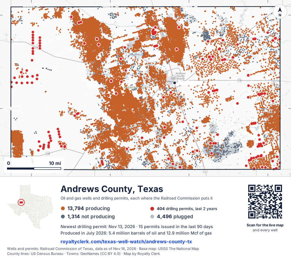
- Drilling locations411Permits issued in the last two years
- Producing wells13,809On a lease reporting production now
- Not producing1,314Shut in, inactive or no lease on record
- Plugged4,481The state's wellbore record says plugged
Sources: Railroad Commission of Texas well layers and permit files, US Census Bureau county outline, town points from GeoNames (CC BY 4.0), base map from USGS The National Map. A dot is a surface location; a horizontal well runs a mile or more from it.
19,604 wells with a location on the state's map and 411 drilling locations permitted in the last 24 months, each where the Railroad Commission puts it.
A permit is not a well.
Andrews County is one of the 61 counties of the Permian Basin
Wells near each town in Andrews County
Wells within 10 miles of each town, on either side of the county line.
Use this map on your site
You may show this map on any site, unchanged. Keep the credit line and its link to Royalty Clerk under the map. The picture updates by itself as the state records new wells and permits.
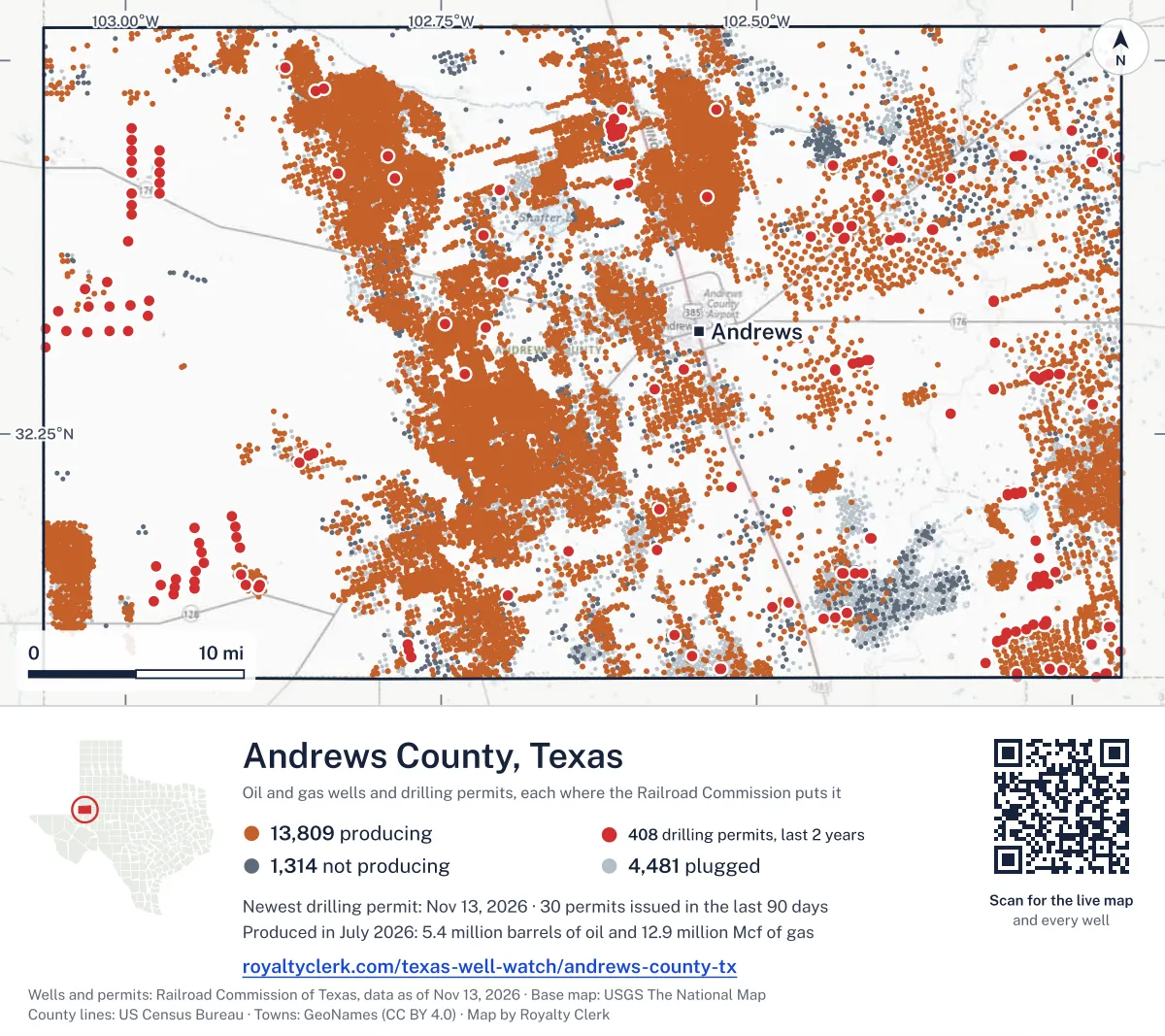
<a href="https://royaltyclerk.com/texas-well-watch/andrews-county-tx"><img src="https://royaltyclerk.com/maps/county-wells/andrews-county-tx.svg" alt="Map of Andrews County, Texas, with 19,604 oil and gas wells and 411 recent drilling locations as dots." width="1000" height="889" loading="lazy" style="max-width:100%;height:auto;border:0"></a>
<p style="margin:4px 0 0;font-size:14px">Map: <a href="https://royaltyclerk.com/texas-well-watch/andrews-county-tx">Andrews County, Texas oil and gas wells</a> by Royalty Clerk, from Railroad Commission of Texas records</p>
The last twelve months
Month by month in Andrews County
| Month | Permits | Completions | First production |
|---|---|---|---|
| Nov 2026 | 1 | 0 | 0 |
| Oct 2026 | 1 | 0 | 0 |
| Sep 2026 | 13 | 0 | 0 |
| Aug 2026 | 43 | 1 | 0 |
| Jul 2026 | 52 | 2 | 0 |
| Jun 2026 | 14 | 15 | 20 |
| May 2026 | 10 | 11 | 5 |
| Apr 2026 | 25 | 12 | 0 |
| Mar 2026 | 3 | 8 | 10 |
| Feb 2026 | 22 | 14 | 1 |
| Jan 2026 | 5 | 30 | 4 |
| Dec 2025 | 10 | 24 | 4 |
| Nov 2025 | 18 | 10 | 0 |
Counted from November 15, 2025 to November 13, 2026, so the first and last months are partial. Source: Railroad Commission of Texas data sets.
Free, no sign-in
The newest drilling permits in Andrews County
| Issued | Lease and well | Operator | Drilling began | Depth, ft | API number | Coordinates | Permit |
|---|---|---|---|---|---|---|---|
| 2026-11-13 | STATE OF TEXAS -T- 4recompletion · verticalOlsen Energy Inc.API 42-003-07191 · permit 092006032.23107, -102.8622410,272 ft | Olsen Energy Inc. | |||||
| 2026-10-22 | SPDTX SWD 7new drill · verticalWaterbridge Stateline LLCAPI 42-003-49464 · permit 091949832.37900, -102.997889,000 ft | Waterbridge Stateline LLC | |||||
| 2026-09-29 | FEE 'BJ' 222WBnew drill · horizontalFasken Oil and Ranch, Ltd.API 42-003-49463 · permit 091892432.08749, -102.2936610,000 ft | Fasken Oil and Ranch, Ltd. | |||||
| 2026-09-29 | FEE 'BJ' 221WAnew drill · horizontalFasken Oil and Ranch, Ltd.API 42-003-49462 · permit 091892332.08744, -102.293649,700 ft | Fasken Oil and Ranch, Ltd. | |||||
| 2026-09-29 | FEE 'BJ' 220DNnew drill · horizontalFasken Oil and Ranch, Ltd.API 42-003-49461 · permit 091892232.08739, -102.293629,600 ft | Fasken Oil and Ranch, Ltd. | |||||
| 2026-09-29 | FEE 'BJ' 219LSnew drill · horizontalFasken Oil and Ranch, Ltd.API 42-003-49460 · permit 091892132.08733, -102.293619,500 ft | Fasken Oil and Ranch, Ltd. | |||||
| 2026-09-29 | FEE 'BJ' 218JMnew drill · horizontalFasken Oil and Ranch, Ltd.API 42-003-49459 · permit 091892032.08728, -102.2935910,000 ft | Fasken Oil and Ranch, Ltd. | |||||
| 2026-09-29 | FEE 'BJ' 217MSnew drill · horizontalFasken Oil and Ranch, Ltd.API 42-003-49458 · permit 091891832.08723, -102.293578,800 ft | Fasken Oil and Ranch, Ltd. | |||||
| 2026-09-22 | UL BLUE WATER 36-25 D 2LSnew drill · horizontalSabalo II Operating, LLCAPI 42-003-49456 · permit 09187709,600 ft | Sabalo II Operating, LLC | |||||
| 2026-09-22 | UL BLUE WATER 36-25 D 1WBnew drill · horizontalSabalo II Operating, LLCAPI 42-003-49457 · permit 091877110,300 ft | Sabalo II Operating, LLC | |||||
| 2026-09-18 | UL BLUE WATER 36-25 C 2JMnew drill · horizontalSabalo II Operating, LLCAPI 42-003-49455 · permit 0918768drilling began 2026-09-25 · 9,200 ft | Sabalo II Operating, LLC | |||||
| 2026-09-18 | UL BLUE WATER 36-25 C 1DNnew drill · horizontalSabalo II Operating, LLCAPI 42-003-49453 · permit 09187699,800 ft | Sabalo II Operating, LLC | |||||
| 2026-09-18 | UL BLUE WATER 36-25 A 1LSnew drill · horizontalSabalo II Operating, LLCAPI 42-003-49454 · permit 091876532.40832, -102.40471drilling began 2026-09-21 · 9,600 ft | Sabalo II Operating, LLC | |||||
| 2026-09-18 | UL BLUE WATER 36-25 A 1JMnew drill · horizontalSabalo II Operating, LLCAPI 42-003-49452 · permit 0918767drilling began 2026-09-23 · 9,200 ft | Sabalo II Operating, LLC | |||||
| 2026-09-14 | LOGSDON, ETAL -D- 4recompletion · verticalTexland Petroleum, L.P.API 42-003-05265 · permit 091852732.48124, -102.842997,000 ft | Texland Petroleum, L.P. | |||||
| 2026-08-21 | FULLERTON CLEARFORK UNIT 6734recompletion · verticalHilcorp Energy CompanyAPI 42-003-46561 · permit 091797132.43569, -102.792037,166 ft | Hilcorp Energy Company | |||||
| 2026-08-20 | RUNNING MAN UNIT 2Bnew drill · horizontalAdmiral Permian Operating LLCAPI 42-003-49443 · permit 091788532.10160, -102.5513311,000 ft | Admiral Permian Operating LLC | |||||
| 2026-08-20 | RUNNING MAN UNIT 1Bnew drill · horizontalAdmiral Permian Operating LLCAPI 42-003-49442 · permit 091788332.10162, -102.5512411,000 ft | Admiral Permian Operating LLC | |||||
| 2026-08-20 | UL CHATFIELD 36F 103HFnew drill · horizontalOvintiv USA Inc.API 42-003-49390 · permit 091704532.43585, -102.2955610,500 ft | Ovintiv USA Inc. | |||||
| 2026-08-19 | UNIVERSITY 6-16H 8Hnew drill · horizontalPioneer Natural Res. USA, Inc.API 42-003-49451 · permit 091790932.49809, -102.2192911,223 ft | Pioneer Natural Res. USA, Inc. | |||||
| 2026-08-19 | UNIVERSITY 6-16G 7Hnew drill · horizontalPioneer Natural Res. USA, Inc.API 42-003-49450 · permit 091790832.49807, -102.2193511,223 ft | Pioneer Natural Res. USA, Inc. | |||||
| 2026-08-19 | UNIVERSITY 6-16F 6Hnew drill · horizontalPioneer Natural Res. USA, Inc.API 42-003-49449 · permit 091790732.49806, -102.2194211,223 ft | Pioneer Natural Res. USA, Inc. | |||||
| 2026-08-19 | UNIVERSITY 6-16E 5Hnew drill · horizontalPioneer Natural Res. USA, Inc.API 42-003-49448 · permit 091790632.49805, -102.2194811,223 ft | Pioneer Natural Res. USA, Inc. | |||||
| 2026-08-19 | UNIVERSITY 6-16D 4Hnew drill · horizontalPioneer Natural Res. USA, Inc.API 42-003-49447 · permit 091790532.49803, -102.2195411,223 ft | Pioneer Natural Res. USA, Inc. | |||||
| 2026-08-19 | UNIVERSITY 6-16C 3Hnew drill · horizontalPioneer Natural Res. USA, Inc.API 42-003-49446 · permit 091790132.49802, -102.2196011,223 ft | Pioneer Natural Res. USA, Inc. | |||||
| 2026-08-19 | UNIVERSITY 6-16B 2Hnew drill · horizontalPioneer Natural Res. USA, Inc.API 42-003-49445 · permit 091789932.49800, -102.2196711,223 ft | Pioneer Natural Res. USA, Inc. | |||||
| 2026-08-19 | UNIVERSITY 6-16A 1Hnew drill · horizontalPioneer Natural Res. USA, Inc.API 42-003-49444 · permit 091789832.49799, -102.2197311,223 ft | Pioneer Natural Res. USA, Inc. | |||||
| 2026-08-19 | UL CHATFIELD 36X 105HDnew drill · horizontalOvintiv USA Inc.API 42-003-49394 · permit 091707632.43593, -102.2952510,500 ft | Ovintiv USA Inc. | |||||
| 2026-08-19 | UL CHATFIELD 36X 106HFnew drill · horizontalOvintiv USA Inc.API 42-003-49393 · permit 091706832.43594, -102.2951710,500 ft | Ovintiv USA Inc. | |||||
| 2026-08-19 | UL CHATFIELD 36G 104HFnew drill · horizontalOvintiv USA Inc.API 42-003-49392 · permit 091705932.43589, -102.2954010,500 ft | Ovintiv USA Inc. | |||||
| 2026-08-18 | LOGSDON, ETAL -B- 22recompletion · verticalTexland Petroleum, L.P.API 42-003-44975 · permit 091787832.47944, -102.849827,569 ft | Texland Petroleum, L.P. | |||||
| 2026-08-18 | UL CHATFIELD 36E 102HDnew drill · horizontalOvintiv USA Inc.API 42-003-49391 · permit 091704632.43582, -102.2957210,500 ft | Ovintiv USA Inc. | |||||
| 2026-08-18 | UL CHATFIELD 36E 101HFnew drill · horizontalOvintiv USA Inc.API 42-003-49389 · permit 091704432.43580, -102.2957910,500 ft | Ovintiv USA Inc. | |||||
| 2026-08-17 | FEE 'BQ' 420WDnew drill · horizontalFasken Oil and Ranch, Ltd.API 42-003-49437 · permit 091785132.11660, -102.3024311,000 ft | Fasken Oil and Ranch, Ltd. | |||||
| 2026-08-17 | FEE 'BQ' 419WBnew drill · horizontalFasken Oil and Ranch, Ltd.API 42-003-49436 · permit 091785032.11655, -102.3024210,000 ft | Fasken Oil and Ranch, Ltd. | |||||
| 2026-08-17 | FEE 'BQ' 418WAnew drill · horizontalFasken Oil and Ranch, Ltd.API 42-003-49435 · permit 091784932.11650, -102.302409,800 ft | Fasken Oil and Ranch, Ltd. | |||||
| 2026-08-17 | FEE 'BQ' 417DNnew drill · horizontalFasken Oil and Ranch, Ltd.API 42-003-49434 · permit 091784832.11645, -102.3023810,100 ft | Fasken Oil and Ranch, Ltd. | |||||
| 2026-08-17 | FEE 'BQ' 416LSnew drill · horizontalFasken Oil and Ranch, Ltd.API 42-003-49433 · permit 091784732.11639, -102.302379,400 ft | Fasken Oil and Ranch, Ltd. | |||||
| 2026-08-17 | FEE 'BQ' 415JMnew drill · horizontalFasken Oil and Ranch, Ltd.API 42-003-49432 · permit 091784532.11634, -102.302359,300 ft | Fasken Oil and Ranch, Ltd. | |||||
| 2026-08-17 | FEE 'BQ' 414MSnew drill · horizontalFasken Oil and Ranch, Ltd.API 42-003-49431 · permit 091784332.11629, -102.302338,900 ft | Fasken Oil and Ranch, Ltd. | |||||
| 2026-08-17 | FEE 'BQ' 413ULnew drill · horizontalFasken Oil and Ranch, Ltd.API 42-003-49429 · permit 091784232.11623, -102.302328,300 ft | Fasken Oil and Ranch, Ltd. | |||||
| 2026-08-17 | UL WILD CARD 3-15 B 1WBnew drill · horizontalSabalo II Operating, LLCAPI 42-003-49441 · permit 091783332.38802, -102.4353410,300 ft | Sabalo II Operating, LLC | |||||
| 2026-08-17 | UL WILD CARD 3-15 B 1LSnew drill · horizontalSabalo II Operating, LLCAPI 42-003-49440 · permit 091783132.38800, -102.435429,600 ft | Sabalo II Operating, LLC | |||||
| 2026-08-17 | UL WILD CARD 3-15 A 1WAnew drill · horizontalSabalo II Operating, LLCAPI 42-003-49439 · permit 091783032.38798, -102.4354910,000 ft | Sabalo II Operating, LLC | |||||
| 2026-08-17 | UL WILD CARD 3-15 A 1JMnew drill · horizontalSabalo II Operating, LLCAPI 42-003-49438 · permit 091782932.38796, -102.435579,200 ft | Sabalo II Operating, LLC | |||||
| 2026-08-14 | UL WILD CARD 3-15 A 1CFnew drill · horizontalSabalo II Operating, LLCAPI 42-003-49430 · permit 091782832.38795, -102.435658,300 ft | Sabalo II Operating, LLC | |||||
| 2026-08-13 | MABEE DDA A53 1011JHnew drill · horizontalCog Operating LLCAPI 42-003-49364 · permit 091686232.28842, -102.2728412,000 ft | Cog Operating LLC | |||||
| 2026-08-13 | MABEE DDA A49 1008AHnew drill · horizontalCog Operating LLCAPI 42-003-49363 · permit 091685632.28844, -102.2727812,000 ft | Cog Operating LLC | |||||
| 2026-08-13 | MABEE DDA A46 1007JHnew drill · horizontalCog Operating LLCAPI 42-003-49362 · permit 091685332.28849, -102.2726012,000 ft | Cog Operating LLC | |||||
| 2026-08-10 | UNIVERSITY 13-45 16new drill · verticalMontare Operating, Ltd.API 42-003-49428 · permit 091768332.32341, -102.7470611,370 ft | Montare Operating, Ltd. |
These are the newest 50 of 726 permits on file for Andrews County. The rest follow, 50 to a page.
A permit is permission to drill, not a well. Source: Railroad Commission of Texas drilling permit files.
Year by year
Drilling permits issued in Andrews County, by year
| Year | Permits issued |
|---|---|
| 2026 so far | 189 |
| 2025 | 212 |
| 2024 | 216 |
| 2023 | 50 |
| 2022 | 47 |
| 2021 | 5 |
| 2019 | 3 |
| 2018 | 3 |
| 2014 | 1 |
Counted from the permit files we hold, which start in 2014; that first year may be partial. Source: Railroad Commission of Texas drilling permit files.
The latest
The most recent records
| Date | What, who and where |
|---|---|
| 2026-11-13 | Permit issued: Olsen Energy Inc.STATE OF TEXAS -T- · A-U378 · permit 0920060 |
| 2026-10-22 | Permit issued: Waterbridge Stateline LLCSPDTX SWD · A-845 · permit 0919498 |
| 2026-09-29 | Permit issued: Fasken Oil and Ranch, Ltd.FEE 'BJ' · A-234 · permit 0918924 |
| 2026-09-29 | Permit issued: Fasken Oil and Ranch, Ltd.FEE 'BJ' · A-234 · permit 0918923 |
| 2026-09-29 | Permit issued: Fasken Oil and Ranch, Ltd.FEE 'BJ' · A-234 · permit 0918922 |
| 2026-09-29 | Permit issued: Fasken Oil and Ranch, Ltd.FEE 'BJ' · A-234 · permit 0918921 |
| 2026-09-29 | Permit issued: Fasken Oil and Ranch, Ltd.FEE 'BJ' · A-234 · permit 0918920 |
| 2026-09-29 | Permit issued: Fasken Oil and Ranch, Ltd.FEE 'BJ' · A-234 · permit 0918918 |
| 2026-09-22 | Permit issued: Sabalo II Operating, LLCUL BLUE WATER 36-25 D · A-U99 · permit 0918770 |
| 2026-09-22 | Permit issued: Sabalo II Operating, LLCUL BLUE WATER 36-25 D · A-U99 · permit 0918771 |
| 2026-09-18 | Permit issued: Sabalo II Operating, LLCUL BLUE WATER 36-25 A · A-U99 · permit 0918765 |
| 2026-09-18 | Permit issued: Sabalo II Operating, LLCUL BLUE WATER 36-25 C · A-U99 · permit 0918768 |
| 2026-09-18 | Permit issued: Sabalo II Operating, LLCUL BLUE WATER 36-25 C · A-U99 · permit 0918769 |
| 2026-09-18 | Permit issued: Sabalo II Operating, LLCUL BLUE WATER 36-25 A · A-U99 · permit 0918767 |
| 2026-09-14 | Permit issued: Texland Petroleum, L.P.LOGSDON, ETAL -D- · A-1970 · permit 0918527 |
Coming up
First checks coming due in Andrews County
- WEST FUHRMAN-MASCHO UNIT, Bce-Mach III LLCby November 28, 2026
- FULLERTON CLEARFORK UNIT, Hilcorp Energy Companyby November 28, 2026
- MEANS /SAN ANDRES/ UNIT, Hilcorp Energy Companyby December 29, 2026
Follow it
Watch Andrews County, or one abstract
What do you want to follow?
Where the land is. Your deed or lease names it.
For example A-1119, or Bush, or T&P 38. Your deed or the tax bill has it.
Other counties
Drilling activity in other counties
Related
Related
- ToolTexas well watchPermit, completion, first production and when the first check is due.
- ToolIs this buyout offer fair?The offer as months of your income, what the acres mean, and the questions to ask.
- ToolIs this lease offer good?Bonus and royalty against the county, and a scan of the lease's clauses.
- Texas dataTexas operator changesWho took over whose leases in the last 24 months.
- ToolLate payment interestDeadlines and the interest a late payment earns.
- Texas dataTexas oil and gas atlas254 counties, every lease, operator and field.
FAQ
Questions people ask
How many wells were permitted in Andrews County in the last year?
The Railroad Commission issued 217 drilling permits in Andrews County in the twelve months to November 13, 2026, and recorded 127 completions and 44 first-production reports. A permit is permission to drill, not a well.
How do I get an alert when a permit is issued near my land in Andrews County?
Choose your abstract on this page, or the whole county, and sign in. You get one email a week, only when something new is recorded after you sign up. The alert says whether an event is on an interest in your Mineral File, on a place you follow, or only nearby.
When is my first royalty check due after a new well?
Natural Resources Code section 91.402(a) says on or before 120 days after the end of the month of first sale of production from the well. The state's first-production month is the closest public marker, so the date on this page is the earliest, not a certainty.
Got a new well on your land?
The first check is due within 120 days after the end of the month of first sale.
Sources
Primary sources, opened on 29 September 2026. Statute text is the current version on statutes.capitol.texas.gov.