
Borden County, Texas
Borden County drilling permits: what the state recorded
- 81drilling permits
- 69completions
- 8first-production reports
- in the last twelve months
Wells by coordinates
Oil wells and drilling locations in Borden County
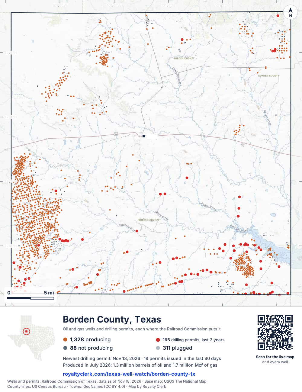
- Drilling locations165Permits issued in the last two years
- Producing wells1,328On a lease reporting production now
- Not producing88Shut in, inactive or no lease on record
- Plugged311The state's wellbore record says plugged
Sources: Railroad Commission of Texas well layers and permit files, US Census Bureau county outline, town points from GeoNames (CC BY 4.0), base map from USGS The National Map. A dot is a surface location; a horizontal well runs a mile or more from it.
1,727 wells with a location on the state's map and 165 drilling locations permitted in the last 24 months, each where the Railroad Commission puts it.
A permit is not a well.
Borden County is one of the 61 counties of the Permian Basin
Wells near each town in Borden County
Wells within 10 miles of each town, on either side of the county line.
Use this map on your site
You may show this map on any site, unchanged. Keep the credit line and its link to Royalty Clerk under the map. The picture updates by itself as the state records new wells and permits.
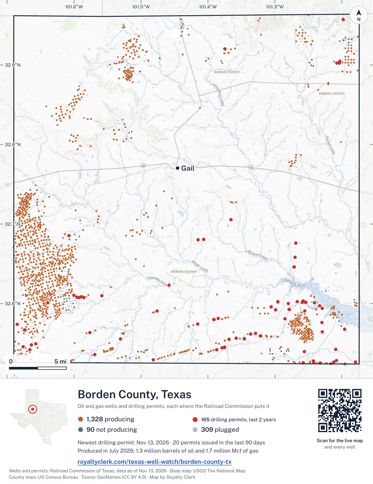
<a href="https://royaltyclerk.com/texas-well-watch/borden-county-tx"><img src="https://royaltyclerk.com/maps/county-wells/borden-county-tx.svg" alt="Map of Borden County, Texas, with 1,727 oil and gas wells and 165 recent drilling locations as dots." width="1000" height="1298" loading="lazy" style="max-width:100%;height:auto;border:0"></a>
<p style="margin:4px 0 0;font-size:14px">Map: <a href="https://royaltyclerk.com/texas-well-watch/borden-county-tx">Borden County, Texas oil and gas wells</a> by Royalty Clerk, from Railroad Commission of Texas records</p>
The last twelve months
Month by month in Borden County
| Month | Permits | Completions | First production |
|---|---|---|---|
| Nov 2026 | 7 | 0 | 0 |
| Oct 2026 | 4 | 0 | 0 |
| Sep 2026 | 5 | 0 | 0 |
| Aug 2026 | 11 | 2 | 0 |
| Jul 2026 | 10 | 5 | 0 |
| Jun 2026 | 6 | 11 | 0 |
| May 2026 | 5 | 4 | 1 |
| Apr 2026 | 6 | 10 | 0 |
| Mar 2026 | 2 | 5 | 3 |
| Feb 2026 | 5 | 9 | 0 |
| Jan 2026 | 7 | 9 | 3 |
| Dec 2025 | 12 | 11 | 1 |
| Nov 2025 | 1 | 3 | 0 |
Counted from November 20, 2025 to November 13, 2026, so the first and last months are partial. Source: Railroad Commission of Texas data sets.
Free, no sign-in
The newest drilling permits in Borden County
| Issued | Lease and well | Operator | Drilling began | Depth, ft | API number | Coordinates | Permit |
|---|---|---|---|---|---|---|---|
| 2026-11-13 | PIXIE UNIT B 35-47 5MHnew drill · horizontalSurge Operating, LLCAPI 42-033-32887 · permit 092005232.54193, -101.387069,000 ft | Surge Operating, LLC | |||||
| 2026-11-12 | PIXIE UNIT A 35-47 4MHnew drill · horizontalSurge Operating, LLCAPI 42-033-32886 · permit 092001032.54187, -101.387029,000 ft | Surge Operating, LLC | |||||
| 2026-11-02 | WRAITH UNIT A 12-16 3MHnew drill · horizontalSurge Operating, LLCAPI 42-033-32885 · permit 091966632.55635, -101.357859,000 ft | Surge Operating, LLC | |||||
| 2026-11-02 | WRAITH UNIT A 12-16 2MHnew drill · horizontalSurge Operating, LLCAPI 42-033-32883 · permit 091966432.55628, -101.357869,000 ft | Surge Operating, LLC | |||||
| 2026-11-02 | ROUGAROU TW 10-16 7MHnew drill · horizontalSurge Operating, LLCAPI 42-033-32882 · permit 091966332.55521, -101.368379,000 ft | Surge Operating, LLC | |||||
| 2026-11-02 | ROUGAROU RW B 36-16 6MHnew drill · horizontalSurge Operating, LLCAPI 42-033-32881 · permit 091966232.55515, -101.368349,000 ft | Surge Operating, LLC | |||||
| 2026-11-02 | ROUGAROU RW A 36-16 5MHnew drill · horizontalSurge Operating, LLCAPI 42-033-32880 · permit 091966132.55508, -101.368329,000 ft | Surge Operating, LLC | |||||
| 2026-10-28 | GUNSMOKE 31-19 C 3JMnew drill · horizontalYukon Exploration Operating, LLCAPI 42-033-32884 · permit 091968432.60862, -101.588758,000 ft | Yukon Exploration Operating, LLC | |||||
| 2026-10-20 | GUNSMOKE 30-31 7Unew drill · horizontalYukon Exploration Operating, LLCAPI 42-033-32879 · permit 091940832.60854, -101.589097,000 ft | Yukon Exploration Operating, LLC | |||||
| 2026-10-20 | GUNSMOKE 30-31 6Mnew drill · horizontalYukon Exploration Operating, LLCAPI 42-033-32878 · permit 091938832.60852, -101.589197,500 ft | Yukon Exploration Operating, LLC | |||||
| 2026-10-20 | GUNSMOKE 30-31 2JMnew drill · horizontalYukon Exploration Operating, LLCAPI 42-033-32877 · permit 091938732.60860, -101.588848,000 ft | Yukon Exploration Operating, LLC | |||||
| 2026-09-04 | WINSTEP 31-9 B UNIT L 6Hnew drill · horizontalHighpeak Energy Holdings, LLCAPI 42-033-32874 · permit 091834732.52497, -101.231827,500 ft | Highpeak Energy Holdings, LLC | |||||
| 2026-09-04 | WINSTEP 31-9 B UNIT A 6Hnew drill · horizontalHighpeak Energy Holdings, LLCAPI 42-033-32876 · permit 091834832.52497, -101.23174drilling began 2026-09-07 · 7,500 ft | Highpeak Energy Holdings, LLC | |||||
| 2026-09-01 | VERDEL 42-54 B UNIT L 6Hnew drill · horizontalHighpeak Energy Holdings, LLCAPI 42-033-32872 · permit 091820932.52497, -101.23190drilling began 2026-09-05 · 7,500 ft | Highpeak Energy Holdings, LLC | |||||
| 2026-09-01 | VERDEL 42-54 B UNIT L 5Hnew drill · horizontalHighpeak Energy Holdings, LLCAPI 42-033-32871 · permit 091820832.52498, -101.23206drilling began 2026-09-04 · 7,500 ft | Highpeak Energy Holdings, LLC | |||||
| 2026-09-01 | VERDEL 42-54 B UNIT A 6Hnew drill · horizontalHighpeak Energy Holdings, LLCAPI 42-033-32870 · permit 091820432.52497, -101.23198drilling began 2026-09-05 · 7,500 ft | Highpeak Energy Holdings, LLC | |||||
| 2026-08-28 | VERDEL 42-54 B UNIT A 5Hnew drill · horizontalHighpeak Energy Holdings, LLCAPI 42-033-32869 · permit 091820132.52498, -101.23214drilling began 2026-09-03 · 7,500 ft | Highpeak Energy Holdings, LLC | |||||
| 2026-08-25 | JOTUNN UNIT A 25-24 1JHnew drill · horizontalSurge Operating, LLCAPI 42-033-32868 · permit 091803032.52943, -101.481429,000 ft | Surge Operating, LLC | |||||
| 2026-08-25 | JOTUNN UNIT A 25-24 1AHnew drill · horizontalSurge Operating, LLCAPI 42-033-32867 · permit 091802932.52936, -101.481409,000 ft | Surge Operating, LLC | |||||
| 2026-08-20 | GUNSIGHT MESA 1new drill · verticalSeaboard Operating Co.API 42-033-32866 · permit 091795132.55574, -101.5304410,000 ft | Seaboard Operating Co. | |||||
| 2026-08-18 | W. D. EVERETT 1re-entry · verticalHighpeak Energy Holdings, LLCAPI 42-033-00638 · permit 091796032.67609, -101.268518,482 ft | Highpeak Energy Holdings, LLC | |||||
| 2026-08-18 | MCDOWELL 1re-entry · verticalHighpeak Energy Holdings, LLCAPI 42-033-30429 · permit 091795732.65838, -101.269768,530 ft | Highpeak Energy Holdings, LLC | |||||
| 2026-08-12 | CHIMERA UNIT A 07-18 3AHnew drill · horizontalSurge Operating, LLCAPI 42-033-32864 · permit 091772932.56363, -101.576309,000 ft | Surge Operating, LLC | |||||
| 2026-08-11 | CHIMERA UNIT B 07-18 4NHnew drill · horizontalSurge Operating, LLCAPI 42-033-32865 · permit 091773532.56356, -101.576289,000 ft | Surge Operating, LLC | |||||
| 2026-08-07 | RAIDER 42-43 B 2JMnew drill · horizontalYukon Exploration Operating, LLCAPI 42-033-32863 · permit 091764432.60850, -101.588918,000 ft | Yukon Exploration Operating, LLC | |||||
| 2026-08-07 | BRAHMA 42-43 3JMnew drill · horizontalYukon Exploration Operating, LLCAPI 42-033-32862 · permit 091764332.60852, -101.588828,000 ft | Yukon Exploration Operating, LLC | |||||
| 2026-08-03 | GRIFFIN-JBT 67-53 B UNIT L 7Hnew drill · horizontalHighpeak Energy Holdings, LLCAPI 42-033-32860 · permit 091730032.60106, -101.240677,500 ft | Highpeak Energy Holdings, LLC | |||||
| 2026-07-29 | GRIFFIN-JBT 67-53 B UNIT A 6Hnew drill · horizontalHighpeak Energy Holdings, LLCAPI 42-033-32861 · permit 091730132.60106, -101.240757,500 ft | Highpeak Energy Holdings, LLC | |||||
| 2026-07-28 | SPHINX UNIT 13-01 1NHnew drill · horizontalSurge Operating, LLCAPI 42-033-32857 · permit 091734832.57983, -101.39093drilling began 2026-08-24 · 9,000 ft | Surge Operating, LLC | |||||
| 2026-07-24 | CRAZY HORSE 24-12 4MHnew drill · horizontalSurge Operating, LLCAPI 42-033-32859 · permit 091736732.68011, -101.414679,000 ft | Surge Operating, LLC | |||||
| 2026-07-24 | CRAZY HORSE 24-12 3JHnew drill · horizontalSurge Operating, LLCAPI 42-033-32858 · permit 091736632.68009, -101.41475drilling began 2026-08-28 · 9,000 ft | Surge Operating, LLC | |||||
| 2026-07-20 | H C WOLF 1re-entry · verticalHighpeak Energy Holdings, LLCAPI 42-033-00614 · permit 091730232.53965, -101.256177,360 ft | Highpeak Energy Holdings, LLC | |||||
| 2026-07-20 | SPHINX UNIT 13-01 4AHnew drill · horizontalSurge Operating, LLCAPI 42-033-32853 · permit 091725932.58127, -101.38450drilling began 2026-08-25 · 9,000 ft | Surge Operating, LLC | |||||
| 2026-07-20 | SPHINX UNIT 13-01 3AHnew drill · horizontalSurge Operating, LLCAPI 42-033-32852 · permit 091725832.58125, -101.384579,000 ft | Surge Operating, LLC | |||||
| 2026-07-20 | SPHINX UNIT 13-01 2AHnew drill · horizontalSurge Operating, LLCAPI 42-033-32851 · permit 091725732.57984, -101.39085drilling began 2026-08-29 · 9,000 ft | Surge Operating, LLC | |||||
| 2026-07-17 | PENG UNIT 14-02 6AHnew drill · horizontalSurge Operating, LLCAPI 42-033-32850 · permit 091716032.57992, -101.39142drilling began 2026-08-18 · 9,000 ft | Surge Operating, LLC | |||||
| 2026-07-06 | CLAYTON, A. M. 'E' NCT-2 2recompletion · verticalYukon Exploration Operating, LLCAPI 42-033-00992 · permit 091683232.61012, -101.558249,779 ft | Yukon Exploration Operating, LLC | |||||
| 2026-06-26 | GRIFFIN 64 SWD 2new drill · verticalHighpeak Energy Holdings, LLCAPI 42-033-32849 · permit 091667432.59227, -101.299057,900 ft | Highpeak Energy Holdings, LLC | |||||
| 2026-06-04 | COYOTE UNIT 411Hnew drill · horizontalFirebird Energy II LLCAPI 42-033-32848 · permit 091597032.56673, -101.673568,325 ft | Firebird Energy II LLC | |||||
| 2026-06-02 | COYOTE UNIT 410Hnew drill · horizontalFirebird Energy II LLCAPI 42-033-32846 · permit 091596432.56671, -101.673658,225 ft | Firebird Energy II LLC | |||||
| 2026-06-02 | COYOTE UNIT 409Hnew drill · horizontalFirebird Energy II LLCAPI 42-033-32845 · permit 091596132.56668, -101.673758,325 ft | Firebird Energy II LLC | |||||
| 2026-06-02 | BANNER EAST 14Hnew drill · horizontalPetroplex Energy Inc.API 42-033-32833 · permit 091455532.52989, -101.664329,000 ft | Petroplex Energy Inc. | |||||
| 2026-06-01 | WOLF RANCHES 40-45 B UNIT M 7Hnew drill · horizontalHighpeak Energy Holdings, LLCAPI 42-033-32847 · permit 091608332.52513, -101.25732drilling began 2026-06-03 · 6,500 ft | Highpeak Energy Holdings, LLC | |||||
| 2026-05-22 | MIRACLES 19-29 6AHnew drill · horizontalSurge Operating, LLCAPI 42-033-32844 · permit 091581532.70547, -101.36576drilling began 2026-07-24 · 9,000 ft | Surge Operating, LLC | |||||
| 2026-05-22 | MIRACLES 19-29 5AHnew drill · horizontalSurge Operating, LLCAPI 42-033-32843 · permit 091581432.70545, -101.36584drilling began 2026-07-18 · 9,000 ft | Surge Operating, LLC | |||||
| 2026-05-19 | MAC 113-137 B UNIT L 7Hnew drill · horizontalHighpeak Energy Holdings, LLCAPI 42-033-32842 · permit 091560632.64602, -101.271306,500 ft | Highpeak Energy Holdings, LLC | |||||
| 2026-05-15 | ALLEN 114-138 A UNIT A 1Hnew drill · horizontalHighpeak Energy Holdings, LLCAPI 42-033-32841 · permit 091560532.64601, -101.271226,500 ft | Highpeak Energy Holdings, LLC | |||||
| 2026-05-05 | WOLF RANCHES 40-45 B UNIT L 7Hnew drill · horizontalHighpeak Energy Holdings, LLCAPI 42-033-32836 · permit 091491232.52547, -101.25731drilling began 2026-05-08 · 6,500 ft | Highpeak Energy Holdings, LLC | |||||
| 2026-04-30 | COYOTE UNIT 422Hnew drill · horizontalFirebird Energy II LLCAPI 42-033-32834 · permit 091485632.60125, -101.639557,960 ft | Firebird Energy II LLC | |||||
| 2026-04-23 | DOLORES WOLF 41-44 A UNIT A 2Hnew drill · horizontalHighpeak Energy Holdings, LLCAPI 42-033-32840 · permit 091499332.52526, -101.257316,500 ft | Highpeak Energy Holdings, LLC |
These are the newest 50 of 273 permits on file for Borden County. The rest follow, 50 to a page.
A permit is permission to drill, not a well. Source: Railroad Commission of Texas drilling permit files.
Year by year
Drilling permits issued in Borden County, by year
| Year | Permits issued |
|---|---|
| 2026 so far | 68 |
| 2025 | 86 |
| 2024 | 97 |
| 2023 | 21 |
| 2022 | 1 |
Counted from the permit files we hold, which start in 2022; that first year may be partial. Source: Railroad Commission of Texas drilling permit files.
The latest
The most recent records
| Date | What, who and where |
|---|---|
| 2026-11-13 | Permit issued: Surge Operating, LLCPIXIE UNIT B 35-47 · A-232 · permit 0920052 |
| 2026-11-12 | Permit issued: Surge Operating, LLCPIXIE UNIT A 35-47 · A-232 · permit 0920010 |
| 2026-11-02 | Permit issued: Surge Operating, LLCWRAITH UNIT A 12-16 · A-792 · permit 0919666 |
| 2026-11-02 | Permit issued: Surge Operating, LLCWRAITH UNIT A 12-16 · A-792 · permit 0919664 |
| 2026-11-02 | Permit issued: Surge Operating, LLCROUGAROU TW 10-16 · A-228 · permit 0919663 |
| 2026-11-02 | Permit issued: Surge Operating, LLCROUGAROU RW B 36-16 · A-228 · permit 0919662 |
| 2026-11-02 | Permit issued: Surge Operating, LLCROUGAROU RW A 36-16 · A-228 · permit 0919661 |
| 2026-10-28 | Permit issued: Yukon Exploration Operating, LLCGUNSMOKE 31-19 C · A-310 · permit 0919684 |
| 2026-10-20 | Permit issued: Yukon Exploration Operating, LLCGUNSMOKE 30-31 · A-310 · permit 0919408 |
| 2026-10-20 | Permit issued: Yukon Exploration Operating, LLCGUNSMOKE 30-31 · A-310 · permit 0919388 |
| 2026-10-20 | Permit issued: Yukon Exploration Operating, LLCGUNSMOKE 30-31 · A-310 · permit 0919387 |
| 2026-09-04 | Permit issued: Highpeak Energy Holdings, LLCWINSTEP 31-9 B UNIT · A-54 · permit 0918348 |
| 2026-09-04 | Permit issued: Highpeak Energy Holdings, LLCWINSTEP 31-9 B UNIT · A-54 · permit 0918347 |
| 2026-09-01 | Permit issued: Highpeak Energy Holdings, LLCVERDEL 42-54 B UNIT · A-54 · permit 0918209 |
| 2026-09-01 | Permit issued: Highpeak Energy Holdings, LLCVERDEL 42-54 B UNIT · A-54 · permit 0918208 |
Coming up
First checks coming due in Borden County
- JO-MILL UNIT, Jo Mill Oil Company LLCby November 28, 2026
- JO-MILL UNIT, Jo Mill Oil Company LLCby November 28, 2026
- JO-MILL UNIT, Jo Mill Oil Company LLCby November 28, 2026
- JO-MILL UNIT, Jo Mill Oil Company LLCby December 29, 2026
- JO-MILL UNIT, Jo Mill Oil Company LLCby December 29, 2026
Follow it
Watch Borden County, or one abstract
What do you want to follow?
Where the land is. Your deed or lease names it.
For example A-1119, or Bush, or T&P 38. Your deed or the tax bill has it.
Other counties
Drilling activity in other counties
Related
Related
- ToolTexas well watchPermit, completion, first production and when the first check is due.
- ToolIs this buyout offer fair?The offer as months of your income, what the acres mean, and the questions to ask.
- ToolIs this lease offer good?Bonus and royalty against the county, and a scan of the lease's clauses.
- Texas dataTexas operator changesWho took over whose leases in the last 24 months.
- ToolLate payment interestDeadlines and the interest a late payment earns.
- Texas dataTexas oil and gas atlas254 counties, every lease, operator and field.
FAQ
Questions people ask
How many wells were permitted in Borden County in the last year?
The Railroad Commission issued 81 drilling permits in Borden County in the twelve months to November 13, 2026, and recorded 69 completions and 8 first-production reports. A permit is permission to drill, not a well.
How do I get an alert when a permit is issued near my land in Borden County?
Choose your abstract on this page, or the whole county, and sign in. You get one email a week, only when something new is recorded after you sign up. The alert says whether an event is on an interest in your Mineral File, on a place you follow, or only nearby.
When is my first royalty check due after a new well?
Natural Resources Code section 91.402(a) says on or before 120 days after the end of the month of first sale of production from the well. The state's first-production month is the closest public marker, so the date on this page is the earliest, not a certainty.
Got a new well on your land?
The first check is due within 120 days after the end of the month of first sale.
Sources
Primary sources, opened on 29 September 2026. Statute text is the current version on statutes.capitol.texas.gov.