
Cooke County, Texas
Cooke County drilling permits: what the state recorded
- 29drilling permits
- 11completions
- 0first-production reports
- in the last twelve months
Wells by coordinates
Oil wells and drilling locations in Cooke County
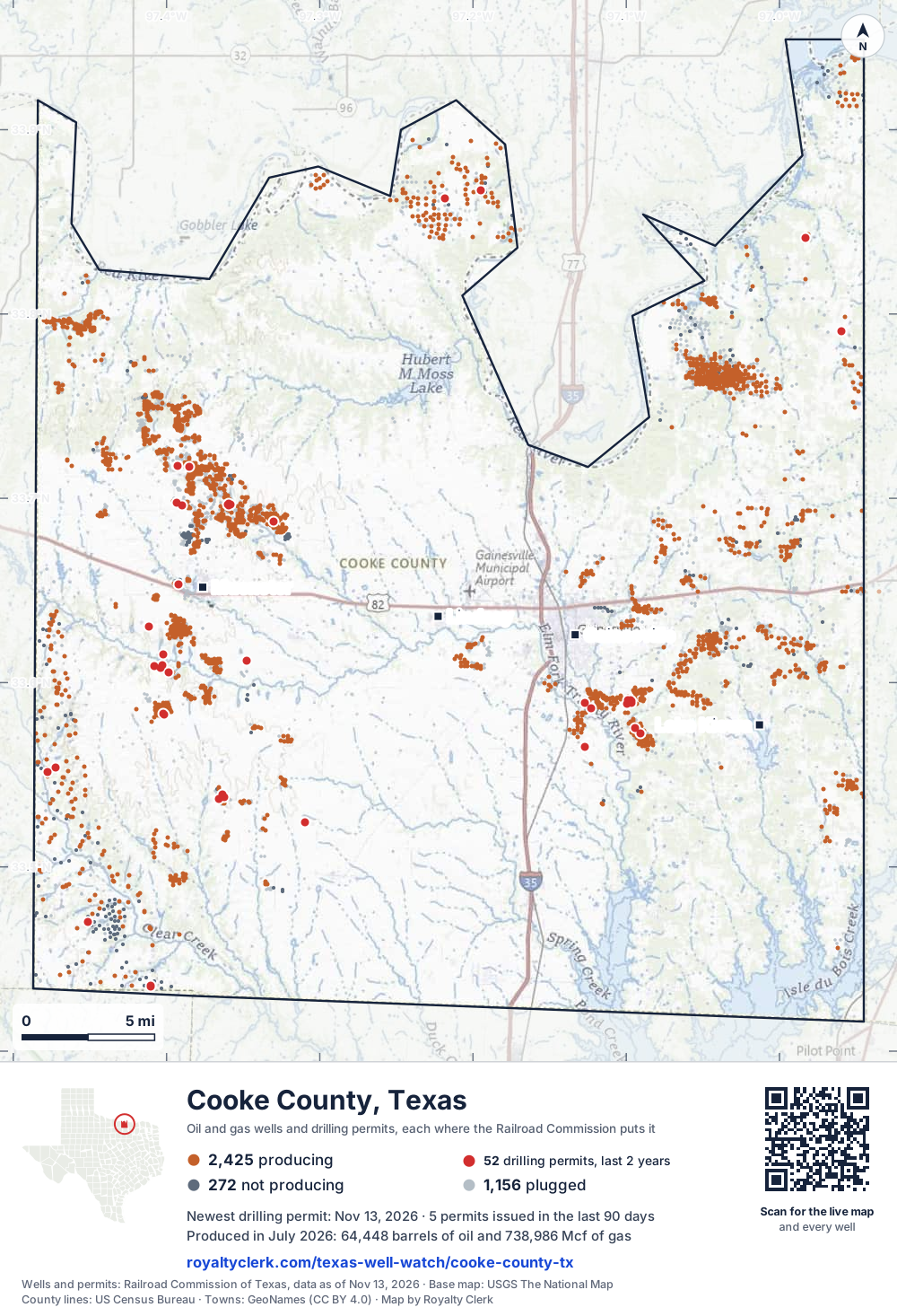
- Drilling locations52Permits issued in the last two years
- Producing wells2,426On a lease reporting production now
- Not producing273Shut in, inactive or no lease on record
- Plugged1,154The state's wellbore record says plugged
Sources: Railroad Commission of Texas well layers and permit files, US Census Bureau county outline, town points from GeoNames (CC BY 4.0), base map from USGS The National Map. A dot is a surface location; a horizontal well runs a mile or more from it.
3,853 wells with a location on the state's map and 52 drilling locations permitted in the last 24 months, each where the Railroad Commission puts it.
A permit is not a well.
Wells near each town in Cooke County
Wells within 10 miles of each town, on either side of the county line.
Use this map on your site
You may show this map on any site, unchanged. Keep the credit line and its link to Royalty Clerk under the map. The picture updates by itself as the state records new wells and permits.
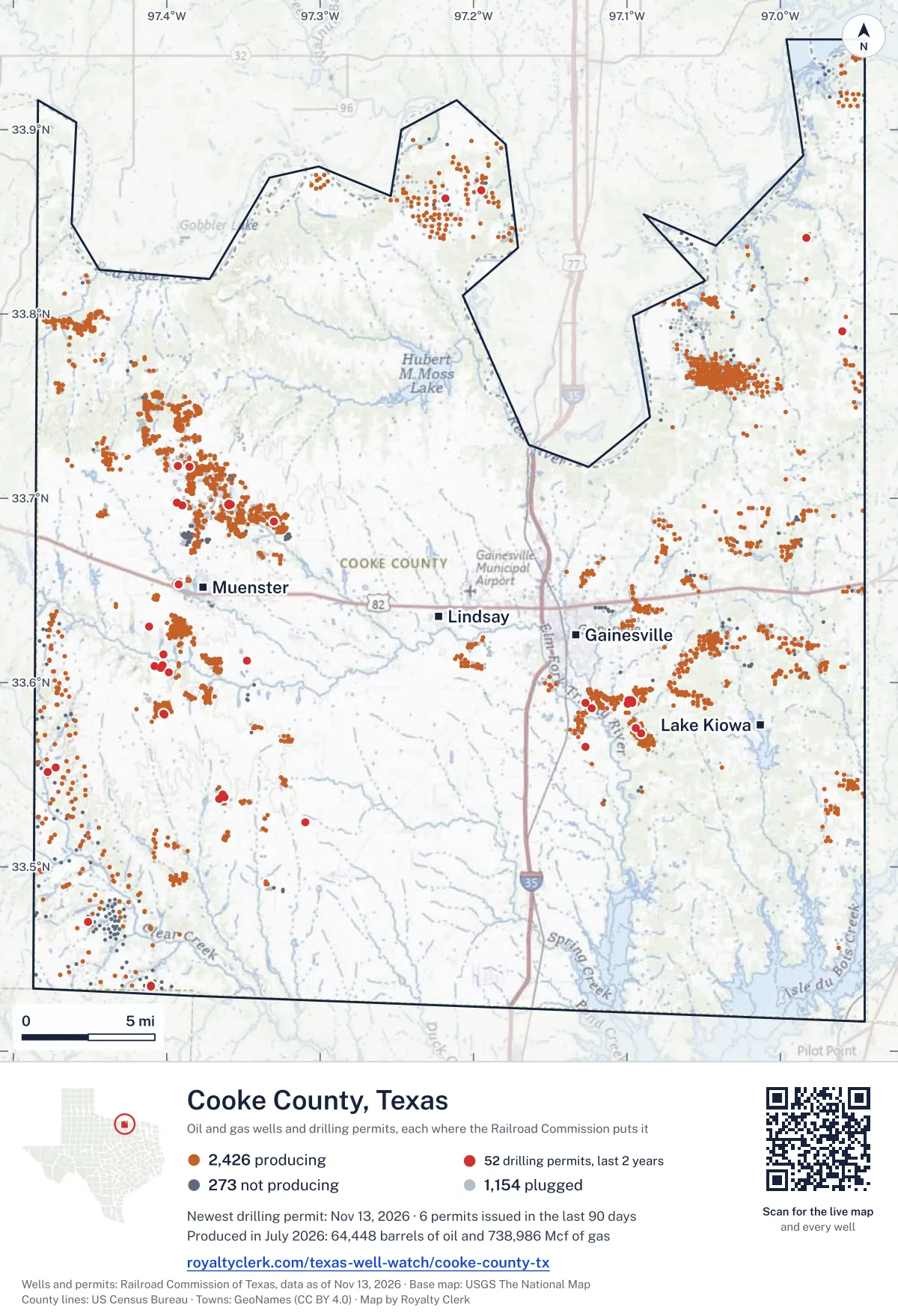
<a href="https://royaltyclerk.com/texas-well-watch/cooke-county-tx"><img src="https://royaltyclerk.com/maps/county-wells/cooke-county-tx.svg" alt="Map of Cooke County, Texas, with 3,853 oil and gas wells and 52 recent drilling locations as dots." width="1000" height="1466" loading="lazy" style="max-width:100%;height:auto;border:0"></a>
<p style="margin:4px 0 0;font-size:14px">Map: <a href="https://royaltyclerk.com/texas-well-watch/cooke-county-tx">Cooke County, Texas oil and gas wells</a> by Royalty Clerk, from Railroad Commission of Texas records</p>
The last twelve months
Month by month in Cooke County
| Month | Permits | Completions | First production |
|---|---|---|---|
| Nov 2026 | 1 | 0 | 0 |
| Oct 2026 | 3 | 0 | 0 |
| Sep 2026 | 1 | 0 | 0 |
| Aug 2026 | 2 | 3 | 0 |
| Jul 2026 | 3 | 1 | 0 |
| Jun 2026 | 5 | 1 | 0 |
| May 2026 | 0 | 2 | 0 |
| Apr 2026 | 2 | 2 | 0 |
| Mar 2026 | 4 | 0 | 0 |
| Jan 2026 | 1 | 1 | 0 |
| Dec 2025 | 7 | 0 | 0 |
| Nov 2025 | 0 | 1 | 0 |
Counted from November 15, 2025 to November 13, 2026, so the first and last months are partial. Source: Railroad Commission of Texas data sets.
Free, no sign-in
The newest drilling permits in Cooke County
| Issued | Lease and well | Operator | Drilling began | Depth, ft | API number | Coordinates | Permit |
|---|---|---|---|---|---|---|---|
| 2026-11-13 | KNIGHT 1Dnew drill · verticalOleum Partners, LLCAPI 42-097-34826 · permit 091985333.47004, -97.4514812,500 ft | Oleum Partners, LLC | |||||
| 2026-10-28 | SCHNIEDERJAN 1new drill · verticalFelderhoff Production CompanyAPI 42-097-34874 · permit 091973033.56493, -97.126783,500 ft | Felderhoff Production Company | |||||
| 2026-10-20 | OPLLC 4-6H GAS UNIT 6Hnew drill · horizontalOleum Partners, LLCAPI 42-097-34873 · permit 091932933.43557, -97.410448,900 ft | Oleum Partners, LLC | |||||
| 2026-10-20 | OPLLC 4-5H GAS UNIT 5Hnew drill · horizontalOleum Partners, LLCAPI 42-097-34872 · permit 091932833.43551, -97.410478,900 ft | Oleum Partners, LLC | |||||
| 2026-09-11 | VESTAL 37new drill · verticalV & H Oil, L.P.API 42-097-34871 · permit 091803333.68727, -97.330001,999 ft | V & H Oil, L.P. | |||||
| 2026-08-20 | TRUBENBACH 1new drill · verticalFelderhoff Production CompanyAPI 42-097-34870 · permit 091794733.61188, -97.347832,100 ft | Felderhoff Production Company | |||||
| 2026-08-07 | KLEMENT, ROBERT 1new drill · verticalFelderhoff Production CompanyAPI 42-097-34869 · permit 091764033.52403, -97.30994drilling began 2026-08-12 · 1,999 ft | Felderhoff Production Company | |||||
| 2026-07-28 | SMITH#1 12new drill · verticalTriple G Well Service, Inc.API 42-097-34868 · permit 091738433.58855, -97.099332,000 ft | Triple G Well Service, Inc. | |||||
| 2026-07-10 | CLEGG NW 1Hnew drill · horizontalOil Capital Operating, LLCAPI 42-097-34867 · permit 091699733.84136, -96.9829017,600 ft | Oil Capital Operating, LLC | |||||
| 2026-07-06 | CAROLYN COLLUMS 1new drill · verticalAtoka Energy LLCAPI 42-097-34774 · permit 091677633.79078, -96.95989drilling began 2026-08-23 · 16,000 ft | Atoka Energy LLC | |||||
| 2026-06-16 | BUTCHER -BC- 23new drill · verticalWFW Production Company, Inc.API 42-097-34862 · permit 091571333.53932, -97.36379drilling began 2026-08-09 · 1,999 ft | WFW Production Company, Inc. | |||||
| 2026-06-10 | VOTH, CRAIG 1new drill · verticalFelderhoff Production CompanyAPI 42-097-34866 · permit 091629133.61534, -97.40197drilling began 2026-07-06 · 2,200 ft | Felderhoff Production Company | |||||
| 2026-06-10 | BONNER 23new drill · verticalFelderhoff Production CompanyAPI 42-097-34865 · permit 091627133.57525, -97.09396drilling began 2026-07-19 · 3,400 ft | Felderhoff Production Company | |||||
| 2026-06-10 | BONNER 22new drill · verticalFelderhoff Production CompanyAPI 42-097-34864 · permit 091627033.57218, -97.09098drilling began 2026-07-24 · 3,400 ft | Felderhoff Production Company | |||||
| 2026-06-09 | CLEGG 2Hnew drill · horizontalOil Capital Operating, LLCAPI 42-097-34863 · permit 091611833.84136, -96.9828016,500 ft | Oil Capital Operating, LLC | |||||
| 2026-04-23 | TONY TRUBENBACH 123new drill · verticalWFW Production Company, Inc.API 42-097-34860 · permit 091440033.71696, -97.385161,999 ft | WFW Production Company, Inc. | |||||
| 2026-04-16 | BRITAIN 3new drill · verticalEOG Resources, Inc.API 42-097-34861 · permit 091444733.55399, -97.472457,000 ft | EOG Resources, Inc. | |||||
| 2026-03-24 | VOGEL UNIT 1new drill · verticalKodiak Oil & Gas, Inc.API 42-097-34859 · permit 091433733.63047, -97.41154drilling began 2026-06-15 · 2,800 ft | Kodiak Oil & Gas, Inc. | |||||
| 2026-03-05 | YARBROUGH 10new drill · verticalFelderhoff Production CompanyAPI 42-097-34858 · permit 091382933.58623, -97.122882,999 ft | Felderhoff Production Company | |||||
| 2026-03-05 | YARBROUGH 'A' 1new drill · verticalFelderhoff Production CompanyAPI 42-097-34857 · permit 091379833.58879, -97.12688drilling began 2026-03-24 · 2,900 ft | Felderhoff Production Company | |||||
| 2026-03-02 | BUTCHER -BC- 7re-entry · verticalWFW Production Company, Inc.API 42-097-31755 · permit 091377233.53707, -97.36556drilling began 2026-04-26 · 1,487 ft | WFW Production Company, Inc. | |||||
| 2026-01-06 | SMITH#1 10new drill · verticalTriple G Well Service, Inc.API 42-097-34854 · permit 091251433.59042, -97.09893drilling began 2026-05-07 · 2,000 ft | Triple G Well Service, Inc. | |||||
| 2025-12-19 | OPLLC 4-3H GAS UNIT 3Hnew drill · horizontalOleum Partners, LLCAPI 42-097-34853 · permit 091231533.43539, -97.410539,200 ft | Oleum Partners, LLC | |||||
| 2025-12-19 | OPLLC 4-2H GAS UNIT 2Hnew drill · horizontalOleum Partners, LLCAPI 42-097-34852 · permit 091231433.43532, -97.410579,000 ft | Oleum Partners, LLC | |||||
| 2025-12-19 | OPLLC 4-1H GAS UNIT 1Hnew drill · horizontalOleum Partners, LLCAPI 42-097-34851 · permit 091230233.43526, -97.410619,000 ft | Oleum Partners, LLC | |||||
| 2025-12-18 | BRITAIN 1recompletion · verticalEOG Resources, Inc.API 42-097-33871 · permit 091222333.55159, -97.477697,000 ft | EOG Resources, Inc. | |||||
| 2025-12-16 | OPLLC 4-4H GAS UNIT 4Hnew drill · horizontalOleum Partners, LLCAPI 42-097-34850 · permit 091210933.43544, -97.410518,900 ft | Oleum Partners, LLC | |||||
| 2025-12-12 | SMITH#1 11new drill · verticalTriple G Well Service, Inc.API 42-097-34849 · permit 091211833.58962, -97.09866drilling began 2025-12-15 · 2,000 ft | Triple G Well Service, Inc. | |||||
| 2025-12-09 | SIVELLS BEND UNIT 814recompletion · verticalSNR Operating, LLCAPI 42-097-34529 · permit 091198633.86691, -97.1949910,062 ft | SNR Operating, LLC | |||||
| 2025-10-08 | TREW,R.W. 'D' 21new drill · verticalV & H Oil, L.P.API 42-097-34835 · permit 090672233.69682, -97.36022drilling began 2026-07-15 · 1,999 ft | V & H Oil, L.P. | |||||
| 2025-10-08 | TREW,R.W. 'D' 19new drill · verticalV & H Oil, L.P.API 42-097-34834 · permit 090671933.69659, -97.358491,999 ft | V & H Oil, L.P. | |||||
| 2025-10-08 | TREW,R.W. 'D' 18new drill · verticalV & H Oil, L.P.API 42-097-34833 · permit 090671733.69613, -97.35959drilling began 2026-07-12 · 1,999 ft | V & H Oil, L.P. | |||||
| 2025-09-18 | J.F. TRUBENBACH -A- 36new drill · verticalWFW Production Company, Inc.API 42-097-34846 · permit 090999833.69626, -97.38958drilling began 2025-10-17 · 1,999 ft | WFW Production Company, Inc. | |||||
| 2025-09-17 | BUTCHER -BC- 22new drill · verticalWFW Production Company, Inc.API 42-097-34848 · permit 091049533.53792, -97.36206drilling began 2025-10-02 · 1,999 ft | WFW Production Company, Inc. | |||||
| 2025-09-17 | BUTCHER -BC- 21new drill · verticalWFW Production Company, Inc.API 42-097-34847 · permit 091049433.53861, -97.36327drilling began 2025-09-29 · 1,999 ft | WFW Production Company, Inc. | |||||
| 2025-08-21 | TREW,R.W. 'D' 20new drill · verticalV & H Oil, L.P.API 42-097-34832 · permit 090671533.69707, -97.359291,999 ft | V & H Oil, L.P. | |||||
| 2025-07-30 | DANGLE 21new drill · verticalWFW Production Company, Inc.API 42-097-34845 · permit 090946033.58241, -97.40165drilling began 2026-08-05 · 1,999 ft | WFW Production Company, Inc. | |||||
| 2025-07-30 | DANGLE 20new drill · verticalWFW Production Company, Inc.API 42-097-34844 · permit 090945933.58325, -97.40229drilling began 2026-08-03 · 1,999 ft | WFW Production Company, Inc. | |||||
| 2025-07-23 | SMITH#1 9new drill · verticalTriple G Well Service, Inc.API 42-097-34843 · permit 090936833.59057, -97.09743drilling began 2025-10-27 · 2,000 ft | Triple G Well Service, Inc. | |||||
| 2025-07-14 | NOEL, ARIANNE A 3new drill · verticalHWH Production, LLCAPI 42-097-34841 · permit 090919433.65327, -97.39242drilling began 2025-08-20 · 1,999 ft | HWH Production, LLC | |||||
| 2025-07-14 | FRANK TRUBENBACH 24new drill · verticalWFW Production Company, Inc.API 42-097-34842 · permit 090918833.71736, -97.39274drilling began 2025-10-14 · 1,999 ft | WFW Production Company, Inc. | |||||
| 2025-07-07 | VOTH, H 14new drill · verticalFelderhoff Production CompanyAPI 42-097-34840 · permit 090906133.60532, -97.39867drilling began 2025-07-08 · 2,100 ft | Felderhoff Production Company | |||||
| 2025-06-26 | VOTH, THEO 2new drill · verticalFelderhoff Production CompanyAPI 42-097-34839 · permit 090887633.60802, -97.40390drilling began 2025-07-01 · 2,200 ft | Felderhoff Production Company | |||||
| 2025-04-23 | SMITH#1 8new drill · verticalTriple G Well Service, Inc.API 42-097-34838 · permit 090750833.58910, -97.09684drilling began 2025-06-18 · 2,000 ft | Triple G Well Service, Inc. | |||||
| 2025-04-22 | VV UNIT 1new drill · verticalFelderhoff Production CompanyAPI 42-097-34837 · permit 090750733.60896, -97.40828drilling began 2025-06-17 · 2,500 ft | Felderhoff Production Company | |||||
| 2025-04-14 | SIVELLS BEND /STRAWN/ UNIT 1406recompletion · verticalSNR Operating, LLCAPI 42-097-34184 · permit 090732533.86252, -97.218587,800 ft | SNR Operating, LLC | |||||
| 2025-03-25 | SMITH#1 7new drill · verticalTriple G Well Service, Inc.API 42-097-34829 · permit 090633233.58993, -97.09683drilling began 2025-04-04 · 2,100 ft | Triple G Well Service, Inc. | |||||
| 2025-03-20 | TRUBENBACH, FRANK 23new drill · verticalWFW Production Company, Inc.API 42-097-34836 · permit 090675833.71739, -97.392721,999 ft | WFW Production Company, Inc. | |||||
| 2025-03-11 | TRUBENBACH, J. F. -A- 35new drill · verticalWFW Production Company, Inc.API 42-097-34831 · permit 090645833.69776, -97.39349drilling began 2025-09-03 · 1,999 ft | WFW Production Company, Inc. | |||||
| 2025-03-11 | TRUBENBACH, J. F. -A- 34new drill · verticalWFW Production Company, Inc.API 42-097-34830 · permit 090645633.69624, -97.389611,999 ft | WFW Production Company, Inc. |
These are the newest 50 of 74 permits on file for Cooke County. The rest follow, 50 to a page.
A permit is permission to drill, not a well. Source: Railroad Commission of Texas drilling permit files.
Year by year
Drilling permits issued in Cooke County, by year
| Year | Permits issued |
|---|---|
| 2026 so far | 22 |
| 2025 | 30 |
| 2024 | 14 |
| 2023 | 5 |
| 2022 | 1 |
| 2021 | 1 |
| 2007 | 1 |
Counted from the permit files we hold, which start in 2007; that first year may be partial. Source: Railroad Commission of Texas drilling permit files.
The latest
The most recent records
| Date | What, who and where |
|---|---|
| 2026-11-13 | Permit issued: Oleum Partners, LLCKNIGHT · A-1503 · permit 0919853 |
| 2026-10-28 | Permit issued: Felderhoff Production CompanySCHNIEDERJAN · A-435 · permit 0919730 |
| 2026-10-20 | Permit issued: Oleum Partners, LLCOPLLC 4-6H GAS UNIT · A-1199 · permit 0919329 |
| 2026-10-20 | Permit issued: Oleum Partners, LLCOPLLC 4-5H GAS UNIT · A-1199 · permit 0919328 |
| 2026-09-11 | Permit issued: V & H Oil, L.P.VESTAL · A-164 · permit 0918033 |
| 2026-08-20 | Permit issued: Felderhoff Production CompanyTRUBENBACH · A-55 · permit 0917947 |
| 2026-08-17 | Completed: WFW Production Company, Inc.BUTCHER -BC- · A-273 · permit 0915713 |
| 2026-08-12 | Completed: WFW Production Company, Inc.DANGLE · A-566 · permit 0909459 |
| 2026-08-12 | Completed: WFW Production Company, Inc.DANGLE · A-566 · permit 0909460 |
| 2026-08-07 | Permit issued: Felderhoff Production CompanyKLEMENT, ROBERT · A-790 · permit 0917640 |
| 2026-07-28 | Permit issued: Triple G Well Service, Inc.SMITH#1 · A-874 · permit 0917384 |
| 2026-07-14 | Completed: V & H Oil, L.P.TREW,R.W. 'D' · A-5 · permit 0906722 |
| 2026-07-10 | Permit issued: Oil Capital Operating, LLCCLEGG NW · A-1290 · permit 0916997 |
| 2026-07-06 | Permit issued: Atoka Energy LLCCAROLYN COLLUMS · A-518 · permit 0916776 |
| 2026-06-16 | Permit issued: WFW Production Company, Inc.BUTCHER -BC- · A-273 · permit 0915713 |
Coming up
First checks coming due in Cooke County
- TREW,R.W. 'D', V & H Oil, L.P.by November 28, 2026
- DANGLE, WFW Production Company, Inc.by December 29, 2026
- DANGLE, WFW Production Company, Inc.by December 29, 2026
- BUTCHER -BC-, WFW Production Company, Inc.by December 29, 2026
Follow it
Watch Cooke County, or one abstract
What do you want to follow?
Where the land is. Your deed or lease names it.
For example A-1119, or Bush, or T&P 38. Your deed or the tax bill has it.
Other counties
Drilling activity in other counties
Related
Related
- ToolTexas well watchPermit, completion, first production and when the first check is due.
- ToolIs this buyout offer fair?The offer as months of your income, what the acres mean, and the questions to ask.
- ToolIs this lease offer good?Bonus and royalty against the county, and a scan of the lease's clauses.
- Texas dataTexas operator changesWho took over whose leases in the last 24 months.
- ToolLate payment interestDeadlines and the interest a late payment earns.
- Texas dataTexas oil and gas atlas254 counties, every lease, operator and field.
FAQ
Questions people ask
How many wells were permitted in Cooke County in the last year?
The Railroad Commission issued 29 drilling permits in Cooke County in the twelve months to November 13, 2026, and recorded 11 completions and 0 first-production reports. A permit is permission to drill, not a well.
How do I get an alert when a permit is issued near my land in Cooke County?
Choose your abstract on this page, or the whole county, and sign in. You get one email a week, only when something new is recorded after you sign up. The alert says whether an event is on an interest in your Mineral File, on a place you follow, or only nearby.
When is my first royalty check due after a new well?
Natural Resources Code section 91.402(a) says on or before 120 days after the end of the month of first sale of production from the well. The state's first-production month is the closest public marker, so the date on this page is the earliest, not a certainty.
Got a new well on your land?
The first check is due within 120 days after the end of the month of first sale.
Sources
Primary sources, opened on 29 September 2026. Statute text is the current version on statutes.capitol.texas.gov.