
Denton County, Texas
Denton County drilling permits: what the state recorded
- 15drilling permits
- 39completions
- 9first-production reports
- in the last twelve months
Wells by coordinates
Oil wells and drilling locations in Denton County
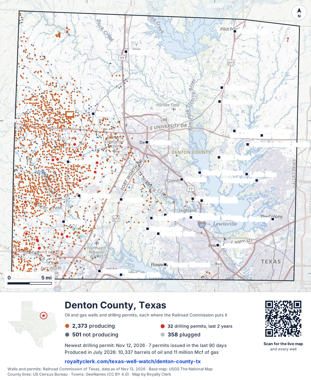
- Drilling locations32Permits issued in the last two years
- Producing wells2,373On a lease reporting production now
- Not producing502Shut in, inactive or no lease on record
- Plugged357The state's wellbore record says plugged
Sources: Railroad Commission of Texas well layers and permit files, US Census Bureau county outline, town points from GeoNames (CC BY 4.0), base map from USGS The National Map. A dot is a surface location; a horizontal well runs a mile or more from it.
3,232 wells with a location on the state's map and 32 drilling locations permitted in the last 24 months, each where the Railroad Commission puts it.
A permit is not a well.
Denton County is one of the 25 counties of the Barnett Shale
Wells near each town in Denton County
- Argyle1,631 wells
- Aubrey4 wells
- Bartonville694 wells
- Copper Canyon472 wells
- Corinth411 wells
- Denton984 wells
- Double Oak519 wells
- Flower Mound367 wells
- Hackberry14 wells
- Hickory Creek262 wells
- Highland Village249 wells
- Justin3,233 wells
- Krugerville5 wells
- Krum1,944 wells
- Lake Dallas224 wells
- Lantana681 wells
- Lewisville217 wells
- Little Elm28 wells
- Northlake2,990 wells
- Oak Point114 wells
- Paloma Creek5 wells
- Paloma Creek South11 wells
- Pilot Point67 wells
- Ponder3,077 wells
- Providence Village12 wells
- Roanoke1,413 wells
- Sanger389 wells
- Savannah1 permit
- Shady Shores237 wells
- The Colony18 wells
- Trophy Club970 wells
Wells within 10 miles of each town, on either side of the county line.
Use this map on your site
You may show this map on any site, unchanged. Keep the credit line and its link to Royalty Clerk under the map. The picture updates by itself as the state records new wells and permits.
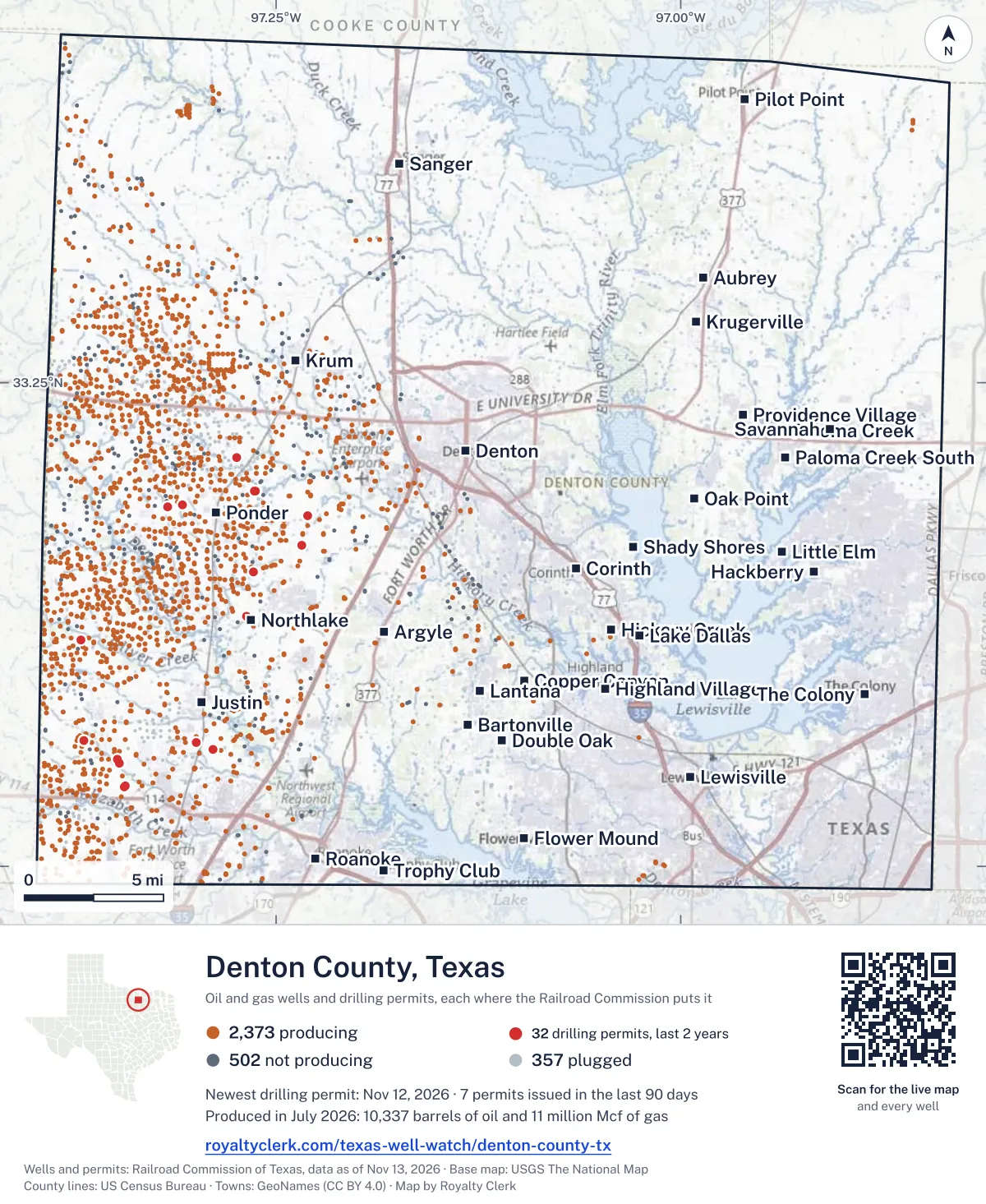
<a href="https://royaltyclerk.com/texas-well-watch/denton-county-tx"><img src="https://royaltyclerk.com/maps/county-wells/denton-county-tx.svg" alt="Map of Denton County, Texas, with 3,232 oil and gas wells and 32 recent drilling locations as dots." width="1000" height="1221" loading="lazy" style="max-width:100%;height:auto;border:0"></a>
<p style="margin:4px 0 0;font-size:14px">Map: <a href="https://royaltyclerk.com/texas-well-watch/denton-county-tx">Denton County, Texas oil and gas wells</a> by Royalty Clerk, from Railroad Commission of Texas records</p>
The last twelve months
Month by month in Denton County
| Month | Permits | Completions | First production |
|---|---|---|---|
| Nov 2026 | 1 | 0 | 0 |
| Oct 2026 | 5 | 0 | 0 |
| Sep 2026 | 1 | 0 | 0 |
| Aug 2026 | 2 | 1 | 0 |
| Jul 2026 | 0 | 3 | 0 |
| Jun 2026 | 2 | 4 | 3 |
| May 2026 | 0 | 8 | 0 |
| Apr 2026 | 0 | 4 | 2 |
| Mar 2026 | 2 | 9 | 0 |
| Feb 2026 | 0 | 1 | 0 |
| Jan 2026 | 0 | 6 | 4 |
| Dec 2025 | 2 | 3 | 0 |
Counted from November 15, 2025 to November 12, 2026, so the first and last months are partial. Source: Railroad Commission of Texas data sets.
Free, no sign-in
The newest drilling permits in Denton County
| Issued | Lease and well | Operator | Drilling began | Depth, ft | API number | Coordinates | Permit |
|---|---|---|---|---|---|---|---|
| 2026-11-12 | SEXTON 5 (AW) 5Hnew drill · horizontalBKV Barnett II, LLCAPI 42-121-34671 · permit 091987933.12914, -97.2684517,541 ft | BKV Barnett II, LLC | |||||
| 2026-10-27 | JE DAY HEIRS 3 (AW) 3Hrecompletion · horizontalBKV Barnett, LLCAPI 42-121-34617 · permit 091952233.04134, -97.343435,976 ft | BKV Barnett, LLC | |||||
| 2026-10-14 | BILTMORE 4 (AW) 4Hrecompletion · horizontalBKV Barnett, LLCAPI 42-121-32379 · permit 091921033.16574, -97.2340712,182 ft | BKV Barnett, LLC | |||||
| 2026-10-13 | DAY HEIRS J E 6 (AW) 6Hnew drill · horizontalBKV Barnett, LLCAPI 42-121-34667 · permit 091908033.04113, -97.3435514,055 ft | BKV Barnett, LLC | |||||
| 2026-10-13 | DAY HEIRS J E 5 (AW) 5Hnew drill · horizontalBKV Barnett, LLCAPI 42-121-34666 · permit 091907933.04107, -97.3435513,123 ft | BKV Barnett, LLC | |||||
| 2026-10-13 | DAY HEIRS J E 4 (AW) 4Hnew drill · horizontalBKV Barnett, LLCAPI 42-121-34665 · permit 091907833.04118, -97.3435515,900 ft | BKV Barnett, LLC | |||||
| 2026-09-18 | ADAMS-DAY HEIRS (SA) 1Hrecompletion · horizontalBKV Barnett, LLCAPI 42-121-33869 · permit 091855833.05531, -97.347988,500 ft | BKV Barnett, LLC | |||||
| 2026-08-06 | HARDEMAN, DOROTHY JEAN 11 (AW) 11Hnew drill · horizontalBKV Barnett, LLCAPI 42-121-34664 · permit 091757833.06385, -97.299298,500 ft | BKV Barnett, LLC | |||||
| 2026-08-04 | DCCO 2 - DCCO 4 (SA) 1Hrecompletion · horizontalBKV Barnett, LLCAPI 42-121-33120 · permit 091748733.11721, -97.3707210,535 ft | BKV Barnett, LLC | |||||
| 2026-06-16 | HARDEMAN, DOROTHY JEAN 10 (AW) 10Hnew drill · horizontalBKV Barnett, LLCAPI 42-121-34663 · permit 091643733.06390, -97.2993113,100 ft | BKV Barnett, LLC | |||||
| 2026-06-16 | ADAMS, CORINNE 8 (AW) 8Hrecompletion · horizontalBKV Barnett, LLCAPI 42-121-32214 · permit 091643533.05318, -97.346609,500 ft | BKV Barnett, LLC | |||||
| 2026-03-13 | NORTH, JERRY 7 (AW) 7Hrecompletion · horizontalBKV Barnett II, LLCAPI 42-121-32718 · permit 091395233.18557, -97.31691drilling began 2006-03-21 · 10,890 ft | BKV Barnett II, LLC | |||||
| 2026-03-06 | ROBSON RANCH 505Hrecompletion · horizontalBKV Barnett II, LLCAPI 42-121-33910 · permit 091379433.15200, -97.26408drilling began 2010-03-03 · 12,000 ft | BKV Barnett II, LLC | |||||
| 2025-12-11 | HADDOCK, E. L. GU 21 (AW) 21Hnew drill · horizontalBKV Barnett, LLCAPI 42-121-34662 · permit 091208633.06483, -97.36903drilling began 2026-02-21 · 18,000 ft | BKV Barnett, LLC | |||||
| 2025-12-11 | HADDOCK, E. L. GU 20 (AW) 20Hnew drill · horizontalBKV Barnett, LLCAPI 42-121-34661 · permit 091208233.06488, -97.36902drilling began 2026-02-20 · 21,000 ft | BKV Barnett, LLC | |||||
| 2025-11-05 | YARBROUGH B ET AL GU 7 (AW) 7Hnew drill · horizontalBKV Barnett, LLCAPI 42-121-34659 · permit 091060733.18133, -97.23055drilling began 2026-03-18 · 22,972 ft | BKV Barnett, LLC | |||||
| 2025-11-05 | YARBROUGH B ET AL GU 6 (AW) 6Hnew drill · horizontalBKV Barnett, LLCAPI 42-121-34658 · permit 091060633.18133, -97.23061drilling began 2026-03-17 · 19,806 ft | BKV Barnett, LLC | |||||
| 2025-11-04 | YARBROUGH B ET AL GU 5 (AW) 5Hnew drill · horizontalBKV Barnett, LLCAPI 42-121-34657 · permit 091060533.18133, -97.23068drilling began 2026-03-17 · 23,949 ft | BKV Barnett, LLC | |||||
| 2025-11-03 | YARBROUGH B ET AL GU 8 (AW) U 8Hnew drill · horizontalBKV Barnett, LLCAPI 42-121-34660 · permit 091060933.18133, -97.23048drilling began 2026-03-19 · 16,900 ft | BKV Barnett, LLC | |||||
| 2025-08-14 | COX 9 (AW) 9Hnew drill · horizontalBKV Barnett, LLCAPI 42-121-34656 · permit 090977233.18695, -97.30764drilling began 2026-07-14 · 11,801 ft | BKV Barnett, LLC | |||||
| 2025-08-14 | COX 8 (AW) 8Hnew drill · horizontalBKV Barnett, LLCAPI 42-121-34653 · permit 090977033.18694, -97.30770drilling began 2026-07-13 · 11,584 ft | BKV Barnett, LLC | |||||
| 2025-08-13 | COX 11 (AW) 11Hnew drill · horizontalBKV Barnett, LLCAPI 42-121-34655 · permit 090977533.18693, -97.30777drilling began 2026-07-13 · 10,987 ft | BKV Barnett, LLC | |||||
| 2025-08-13 | COX 10 (AW) 10Hnew drill · horizontalBKV Barnett, LLCAPI 42-121-34654 · permit 090977433.18693, -97.30783drilling began 2026-07-12 · 12,644 ft | BKV Barnett, LLC | |||||
| 2025-05-29 | SANDFIELD L P 20 (AW) 20Hnew drill · horizontalBKV Barnett, LLCAPI 42-121-34652 · permit 090823133.21149, -97.27451drilling began 2025-09-30 · 10,350 ft | BKV Barnett, LLC | |||||
| 2025-05-29 | SANDFIELD L P 19 (AW) 19Hnew drill · horizontalBKV Barnett, LLCAPI 42-121-34651 · permit 090822733.21144, -97.274499,200 ft | BKV Barnett, LLC | |||||
| 2025-05-29 | SANDFIELD L P 18 (AW) 18Hnew drill · horizontalBKV Barnett, LLCAPI 42-121-34650 · permit 090820833.21139, -97.27447drilling began 2025-09-29 · 9,300 ft | BKV Barnett, LLC | |||||
| 2025-05-29 | SANDFIELD L P 17 (AW) 17Hnew drill · horizontalBKV Barnett, LLCAPI 42-121-34649 · permit 090820533.21133, -97.27445drilling began 2025-09-28 · 9,500 ft | BKV Barnett, LLC | |||||
| 2025-04-24 | NICHOLSON 16 (AW) 16Hnew drill · horizontalBKV Barnett, LLCAPI 42-121-34647 · permit 090734533.19418, -97.26307drilling began 2025-06-23 · 18,801 ft | BKV Barnett, LLC | |||||
| 2025-04-23 | NICHOLSON 17 (AW) 17Hnew drill · horizontalBKV Barnett, LLCAPI 42-121-34648 · permit 090734633.19418, -97.26301drilling began 2025-06-23 · 19,121 ft | BKV Barnett, LLC | |||||
| 2025-04-14 | NICHOLSON 15 (AW) 15Hnew drill · horizontalBKV Barnett, LLCAPI 42-121-34646 · permit 090734433.19418, -97.26314drilling began 2025-06-24 · 17,787 ft | BKV Barnett, LLC | |||||
| 2025-04-14 | SMITH, H. A. 12 (AW) 12Hnew drill · horizontalBKV Barnett, LLCAPI 42-121-34645 · permit 090733433.06051, -97.28912drilling began 2025-06-06 · 16,515 ft | BKV Barnett, LLC | |||||
| 2025-04-14 | SMITH, H. A. 11 (AW) 11Hnew drill · horizontalBKV Barnett, LLCAPI 42-121-34644 · permit 090733333.06056, -97.28912drilling began 2025-06-05 · 17,828 ft | BKV Barnett, LLC | |||||
| 2024-09-23 | POOL B 13 (AW) 13Hnew drill · horizontalBKV Barnett, LLCAPI 42-121-34616 · permit 090281133.00383, -97.394787,395 ft | BKV Barnett, LLC | |||||
| 2024-09-23 | POOL B 12 (AW) 12Hnew drill · horizontalBKV Barnett, LLCAPI 42-121-34615 · permit 090281033.00391, -97.394787,325 ft | BKV Barnett, LLC | |||||
| 2024-09-23 | POOL B 11 (AW) 11Hnew drill · horizontalBKV Barnett, LLCAPI 42-121-34614 · permit 090280933.00387, -97.394787,395 ft | BKV Barnett, LLC | |||||
| 2024-09-23 | POOL B 10 (AW) 10Hnew drill · horizontalBKV Barnett, LLCAPI 42-121-34613 · permit 090280833.00395, -97.394787,224 ft | BKV Barnett, LLC | |||||
| 2024-05-24 | CARL MCCURLEY 2 (AW) 2Hnew drill · horizontalBKV Barnett, LLCAPI 42-121-34641 · permit 089961033.11505, -97.2193013,680 ft | BKV Barnett, LLC | |||||
| 2024-05-23 | CARL MCCURLEY 4 (AW) 4Hnew drill · horizontalBKV Barnett, LLCAPI 42-121-34643 · permit 089962033.11510, -97.21930drilling began 2025-03-27 · 17,500 ft | BKV Barnett, LLC | |||||
| 2024-05-14 | CARL MCCURLEY 3 (AW) 3Hnew drill · horizontalBKV Barnett, LLCAPI 42-121-34642 · permit 089961733.11499, -97.21930drilling began 2025-03-26 · 12,362 ft | BKV Barnett, LLC | |||||
| 2023-12-04 | HK ARMSTRONG 12re-entry · verticalMash Oilfield Services, LPAPI 42-121-00185 · permit 089567533.39738, -97.305781,745 ft | Mash Oilfield Services, LP | |||||
| 2023-12-01 | DCCO 3 - J H RIGGS 15 (AW) 15Hnew drill · horizontalBKV Barnett, LLCAPI 42-121-34640 · permit 089449433.17313, -97.32126drilling began 2025-02-08 · 17,013 ft | BKV Barnett, LLC | |||||
| 2023-12-01 | DCCO 3 - J H RIGGS 14 (AW) 14Hnew drill · horizontalBKV Barnett, LLCAPI 42-121-34639 · permit 089449133.17313, -97.32120drilling began 2025-02-08 · 15,717 ft | BKV Barnett, LLC | |||||
| 2023-12-01 | DCCO 3 - J H RIGGS 13 (AW) 13Hnew drill · horizontalBKV Barnett, LLCAPI 42-121-34638 · permit 089448733.17313, -97.32133drilling began 2025-02-07 · 16,109 ft | BKV Barnett, LLC | |||||
| 2023-12-01 | DCCO 3 - J H RIGGS 12 (AW) 12Hnew drill · horizontalBKV Barnett, LLCAPI 42-121-34637 · permit 089448433.17314, -97.32146drilling began 2025-02-06 · 17,410 ft | BKV Barnett, LLC | |||||
| 2023-12-01 | DCCO 3 - J H RIGGS 11 (AW) 11Hnew drill · horizontalBKV Barnett, LLCAPI 42-121-34636 · permit 089448133.17314, -97.32139drilling began 2025-02-07 · 19,131 ft | BKV Barnett, LLC | |||||
| 2006-03-24 | J.D. DAWSON 1Dnew drill · verticalBKV Barnett, LLCAPI 42-121-32822 · permit 061640733.13077, -97.28290drilling began 2006-07-10 · 9,000 ft | BKV Barnett, LLC | |||||
| 2004-07-30 | SEXTON 3new drill · horizontalBKV Barnett II, LLCAPI 42-121-32349 · permit 054692033.12795, -97.26718drilling began 2004-08-05 · 9,450 ft | BKV Barnett II, LLC |
A permit is permission to drill, not a well. Source: Railroad Commission of Texas drilling permit files.
Year by year
Drilling permits issued in Denton County, by year
| Year | Permits issued |
|---|---|
| 2026 so far | 13 |
| 2025 | 19 |
| 2024 | 7 |
| 2023 | 6 |
| 2006 | 1 |
| 2004 | 1 |
Counted from the permit files we hold, which start in 2004; that first year may be partial. Source: Railroad Commission of Texas drilling permit files.
The latest
The most recent records
| Date | What, who and where |
|---|---|
| 2026-11-12 | Permit issued: BKV Barnett II, LLCSEXTON 5 (AW) · A-1291 · permit 0919879 |
| 2026-10-27 | Permit issued: BKV Barnett, LLCJE DAY HEIRS 3 (AW) · A-214 · permit 0919522 |
| 2026-10-14 | Permit issued: BKV Barnett, LLCBILTMORE 4 (AW) · A-989 · permit 0919210 |
| 2026-10-13 | Permit issued: BKV Barnett, LLCDAY HEIRS J E 6 (AW) · A-214 · permit 0919080 |
| 2026-10-13 | Permit issued: BKV Barnett, LLCDAY HEIRS J E 5 (AW) · A-214 · permit 0919079 |
| 2026-10-13 | Permit issued: BKV Barnett, LLCDAY HEIRS J E 4 (AW) · A-214 · permit 0919078 |
| 2026-09-18 | Permit issued: BKV Barnett, LLCADAMS-DAY HEIRS (SA) · A-225 · permit 0918558 |
| 2026-08-11 | Completed: BKV Barnett, LLCCOLE TRUSTS 576 "A" · A-873 |
| 2026-08-06 | Permit issued: BKV Barnett, LLCHARDEMAN, DOROTHY JEAN 11 (AW) · A-993 · permit 0917578 |
| 2026-08-04 | Permit issued: BKV Barnett, LLCDCCO 2 - DCCO 4 (SA) · A-914 · permit 0917487 |
| 2026-07-26 | Completed: BKV Barnett, LLCHARDEMAN, DOROTHY JEAN · A-993 |
| 2026-07-23 | Completed: BKV Barnett, LLCDOOLEY, DAVID M. · A-1127 |
| 2026-07-21 | Completed: BKV Barnett II, LLCMCCUTCHIN GAS UNIT · A-1244 |
| 2026-06-26 | Completed: BKV Barnett, LLCHADDOCK, E. L. GU (AW) · A-679 |
| 2026-06-22 | Completed: BKV Barnett II, LLCNORTH, JERRY · A-902 |
Coming up
First checks coming due in Denton County
- HARDEMAN, DOROTHY JEAN, BKV Barnett, LLCby November 28, 2026
- MCCUTCHIN GAS UNIT, BKV Barnett II, LLCby November 28, 2026
- DOOLEY, DAVID M., BKV Barnett, LLCby November 28, 2026
- COLE TRUSTS 576 "A", BKV Barnett, LLCby December 29, 2026
Follow it
Watch Denton County, or one abstract
What do you want to follow?
Where the land is. Your deed or lease names it.
For example A-1119, or Bush, or T&P 38. Your deed or the tax bill has it.
Other counties
Drilling activity in other counties
Related
Related
- ToolTexas well watchPermit, completion, first production and when the first check is due.
- ToolIs this buyout offer fair?The offer as months of your income, what the acres mean, and the questions to ask.
- ToolIs this lease offer good?Bonus and royalty against the county, and a scan of the lease's clauses.
- Texas dataTexas operator changesWho took over whose leases in the last 24 months.
- ToolLate payment interestDeadlines and the interest a late payment earns.
- Texas dataTexas oil and gas atlas254 counties, every lease, operator and field.
FAQ
Questions people ask
How many wells were permitted in Denton County in the last year?
The Railroad Commission issued 15 drilling permits in Denton County in the twelve months to November 12, 2026, and recorded 39 completions and 9 first-production reports. A permit is permission to drill, not a well.
How do I get an alert when a permit is issued near my land in Denton County?
Choose your abstract on this page, or the whole county, and sign in. You get one email a week, only when something new is recorded after you sign up. The alert says whether an event is on an interest in your Mineral File, on a place you follow, or only nearby.
When is my first royalty check due after a new well?
Natural Resources Code section 91.402(a) says on or before 120 days after the end of the month of first sale of production from the well. The state's first-production month is the closest public marker, so the date on this page is the earliest, not a certainty.
Got a new well on your land?
The first check is due within 120 days after the end of the month of first sale.
Sources
Primary sources, opened on 29 September 2026. Statute text is the current version on statutes.capitol.texas.gov.