
Texas county · RRC district 09
Denton County, Texas oil and gas
- 131,474,024mcf gas in the last 12 months
- 2,370producing leases
- 3,232wells on the map
- 32drilling locations in two years
Oil wells and drilling locations in Denton County
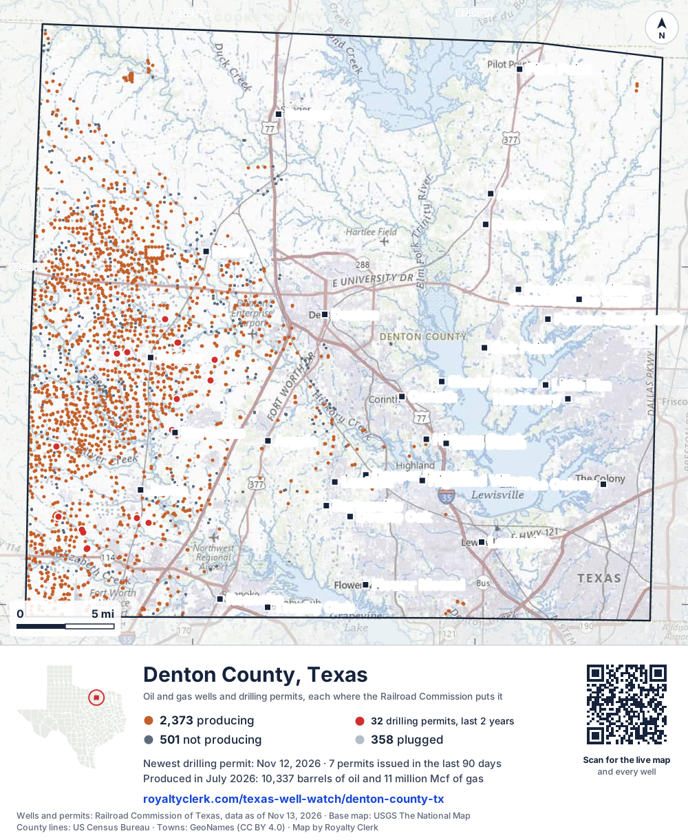
- Drilling locations32Permits issued in the last two years
- Producing wells2,373On a lease reporting production now
- Not producing502Shut in, inactive or no lease on record
- Plugged357The state's wellbore record says plugged
Sources: Railroad Commission of Texas well layers and permit files, US Census Bureau county outline, town points from GeoNames (CC BY 4.0), base map from USGS The National Map. A dot is a surface location; a horizontal well runs a mile or more from it.
3,232 wells with a location on the state's map (2,373 producing, 502 not producing, 357 plugged) and 32 drilling locations permitted in the last 24 months, each where the Railroad Commission puts it.
Use this map on your site
You may show this map on any site, unchanged. Keep the credit line and its link to Royalty Clerk under the map. The picture updates by itself as the state records new wells and permits.
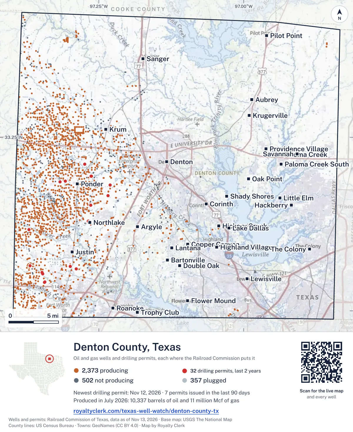
<a href="https://royaltyclerk.com/texas/counties/denton-county-tx"><img src="https://royaltyclerk.com/maps/county-wells/denton-county-tx.svg" alt="Map of Denton County, Texas, with 3,232 oil and gas wells and 32 recent drilling locations as dots." width="1000" height="1221" loading="lazy" style="max-width:100%;height:auto;border:0"></a>
<p style="margin:4px 0 0;font-size:14px">Map: <a href="https://royaltyclerk.com/texas/counties/denton-county-tx">Denton County, Texas oil and gas wells</a> by Royalty Clerk, from Railroad Commission of Texas records</p>
Wells near a town: Argyle · Aubrey · Bartonville · Copper Canyon · Corinth · Denton · Double Oak · Flower Mound · Hackberry · Hickory Creek · Highland Village · Justin · Krugerville · Krum · Lake Dallas · Lantana · Lewisville · Little Elm · Northlake · Oak Point · Paloma Creek · Paloma Creek South · Pilot Point · Ponder · Providence Village · Roanoke · Sanger · Savannah · Shady Shores · The Colony · Trophy Club · Newest drilling permits in Denton County · Wells by ZIP code
Denton County is one of the 25 counties of the Barnett Shale
Denton County reported 131 million mcf of gas and 148,019 barrels of oil in the last 12 months. That ranks 26th of 197 Texas counties by gas.
County dossier
August 2026 is still coming in. About 89% of Texas leases have reported it so far, so this page counts through July 2026 until it is fully reported.
- Producing leases
- 2,370of 3,218 on record
- Operators
- 28
- Fields
- 12
- Top operator
- BKV Barnett, LLC
Own minerals in Denton County?
A family member owned minerals here?
Search their name: a family member who owned minerals hereWhere it sits
This county
- Oil, last 12 months
- 148,019 bbl
- Share of Texas gas
- 1.0%
- Wells on record
- 3,236on leases with production reports
- Data through
- Jul 2026
Five years of output in Denton County
Gas output in Denton County rose 5% over the last 12 months
131M mcf through Jul 2026, against 126M mcf a year earlier. Peak Oct 2022: 12M mcf.
Oil output in Denton County fell 37% over the last 12 months
148k bbl through Jul 2026, against 235k bbl a year earlier. Peak Oct 2022: 51k bbl.
SourceTexas Railroad Commission Production Data Query, county totals, through Jul 2026, file dated Oct 20, 2026.
Cite or embed this chart
Free to use for Denton County, Texas, with a credit and a link. Copy what you need.
Credit line
Source: Royalty Clerk analysis of Texas Railroad Commission filings, https://royaltyclerk.com/texas/counties/denton-county-tx, data to July 2026.
The chart on your own page
Free to embed on any site. Keep the “Source: Royalty Clerk” link under the chart.
See the code
<iframe
  src="https://royaltyclerk.com/embed/counties/denton-county-tx"
  title="Royalty Clerk: oil and gas production, Denton County, Texas"
  width="100%"
  height="400"
  style="border:0"
  loading="lazy"></iframe>
<p style="margin:4px 0 0;font-size:14px">Source: <a href="https://royaltyclerk.com/texas/counties/denton-county-tx" target="_blank">Royalty Clerk</a></p>
<script>
window.addEventListener("message", function (e) {
  if (e.origin !== "https://royaltyclerk.com" || !e.data || e.data.type !== "rc-embed-height") return;
  var frames = document.getElementsByTagName("iframe");
  for (var i = 0; i < frames.length; i++) {
    if (frames[i].contentWindow === e.source && e.data.height > 0) frames[i].style.height = Number(e.data.height) + "px";
  }
});
</script>
Denton County oil and gas production by year, 1993 to 2025
Every full year we hold, 1993 to 2025. The highest year for oil since 1993 was 2004, at 776,259 bbl. The highest year for gas was 2011, at 260,329,715 mcf.
| Year | Oilbbl | Gasmcf |
|---|---|---|
| 2025 | 186,364 | 130,726,764 |
| 2024 | 209,479 | 125,062,441 |
| 2023 | 242,150 | 138,481,635 |
| 2022 | 252,802 | 135,049,680 |
| 2021 | 139,746 | 132,035,167 |
| 2020 | 200,134 | 146,570,035 |
| 2019 | 173,808 | 158,681,626 |
| 2018 | 177,112 | 170,738,412 |
| 2017 | 207,218 | 185,041,964 |
| 2016 | 301,452 | 201,166,429 |
| 2015 | 347,059 | 217,586,723 |
| 2014 | 491,209 | 231,721,456 |
| 2013 | 452,765 | 228,763,706 |
| 2012 | 390,714 | 251,561,786 |
| 2011 | 499,450 | 260,329,715 |
| 2010 | 438,206 | 230,874,727 |
| 2009 | 548,122 | 234,814,729 |
| 2008 | 539,639 | 211,866,333 |
| 2007 | 549,281 | 177,594,313 |
| 2006 | 726,940 | 162,915,736 |
| 2005 | 767,839 | 152,739,770 |
| 2004 | 776,259 | 141,524,488 |
| 2003 | 667,091 | 126,327,600 |
| 2002 | 536,857 | 103,767,742 |
| 2001 | 232,823 | 56,387,581 |
| 2000 | 54,747 | 27,965,427 |
| 1999 | 8,412 | 12,461,010 |
| 1998 | 13,606 | 9,864,072 |
| 1997 | 13,530 | 8,646,254 |
| 1996 | 15,985 | 9,963,645 |
| 1995 | 19,116 | 6,673,731 |
| 1994 | 16,179 | 4,873,423 |
| 1993 | 13,892 | 3,436,164 |
SourceTexas Railroad Commission production records, added up by county and calendar year. Oil includes condensate; gas includes casinghead gas. The year in progress is left out until it is complete.
Denton County appraisal district, 2026 mineral roll
Mineral owners in Denton County: 62,255 royalty records on the roll
At least 526 of the 62,255 royalty-interest records on Denton County's 2026 mineral roll are still titled to an estate (0.84%). We publish counts only. No owner’s name or address is on this page; to look for one family, search its name.
- Royalty-interest records, 2026 roll
- 62,255
- Still titled to an estate, at least
- 526
- Share of the roll
- 0.84%
SourceRoyalty Clerk count of the Denton County mineral appraisal roll of 2026, read November 2026. A record is one line of the roll, not one person.
The biggest leases in Denton County
Under each volume: change on the year before.
1,930,840mcf gasn/a
1,504,816mcf gasn/a
1,271,734mcf gasn/a
1,153,853mcf gasn/a
1,143,893mcf gasn/a
1,012,976mcf gasn/a
986,465mcf gasn/a
918,628mcf gasn/a
810,144mcf gasn/a
697,329mcf gasn/a
695,243mcf gasn/a
688,269mcf gas−18%
679,677mcf gasn/a
652,468mcf gasn/a
640,027mcf gasn/a
637,048mcf gasn/a
- SANDFIELD L P 20 (AW)
611,901mcf gasn/a
- SANDFIELD L P 19 (AW)
607,911mcf gasn/a
600,692mcf gasn/a
588,359mcf gas−14%
583,580mcf gas−14%
573,601mcf gasn/a
571,551mcf gasn/a
- SANDFIELD L P 18 (AW)
567,165mcf gasn/a
- HANGING "W" RANCH
540,506mcf gasn/a
Showing 25 of 150 (the 150 largest of 2,370), ranked by output value.
SourceTexas Railroad Commission Production Data Query.
Who runs the leases, and what they produce
Operators in Denton County, by gas
BKV Barnett leads
- BKV Barnett, LLC1,343 leases83Mmcf
- Eagleridge Operating, LLC362 leases18Mmcf
- Lime Rock Resources IV-A, L.P.327 leases14Mmcf
- BKV Barnett II, LLC173 leases8.9Mmcf
- BKV North Texas, LLC39 leases2.3Mmcf
- Lakota Energy, Ltd.13 leases1.1Mmcf
- Hillwood O & G Operating Co LP12 leases714kmcf
- Upp Operating, LLC5 leases509kmcf
Fields in Denton County, by gas
Newark, East (Barnett Shale) leads
- Newark, East (Barnett Shale)2,278 leases · District 09 · Field 65280200129Mmcf
- Boonsville (Bend Congl., Gas)52 leases · District 09 · Field 10574520812kmcf
- Gas Finders (Congl.)28 leases · District 09 · Field 34128300125kmcf
- Hunter Creek (Conglomerate)1 lease · District 09 · Field 4370750011.4kmcf
- Monteath (Atoka, Upper)1 lease · District 09 · Field 625801003,354mcf
- Bolivar2 leases · District 09 · Field 1027500111mcf
More operators here
Recent drilling permits in Denton County
SEXTON 5 (AW) #5H
new drill · horizontal · BKV Barnett II, LLC · Denton County
Permit 0919879 · Nov 12, 2026
JE DAY HEIRS 3 (AW) #3H
recompletion · horizontal · BKV Barnett, LLC · Denton County
Permit 0919522 · Oct 27, 2026
BILTMORE 4 (AW) #4H
recompletion · horizontal · BKV Barnett, LLC · Denton County
Permit 0919210 · Oct 14, 2026
DAY HEIRS J E 6 (AW) #6H
new drill · horizontal · BKV Barnett, LLC · Denton County
Permit 0919080 · Oct 13, 2026
DAY HEIRS J E 5 (AW) #5H
new drill · horizontal · BKV Barnett, LLC · Denton County
Permit 0919079 · Oct 13, 2026
DAY HEIRS J E 4 (AW) #4H
new drill · horizontal · BKV Barnett, LLC · Denton County
Permit 0919078 · Oct 13, 2026