
Fisher County, Texas
Fisher County drilling permits: what the state recorded
- 15drilling permits
- 10completions
- 2first-production reports
- in the last twelve months
Wells by coordinates
Oil wells and drilling locations in Fisher County
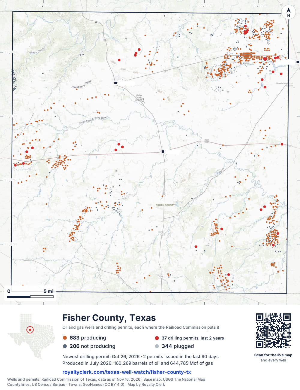
- Drilling locations37Permits issued in the last two years
- Producing wells684On a lease reporting production now
- Not producing206Shut in, inactive or no lease on record
- Plugged343The state's wellbore record says plugged
Sources: Railroad Commission of Texas well layers and permit files, US Census Bureau county outline, town points from GeoNames (CC BY 4.0), base map from USGS The National Map. A dot is a surface location; a horizontal well runs a mile or more from it.
1,233 wells with a location on the state's map and 37 drilling locations permitted in the last 24 months, each where the Railroad Commission puts it.
A permit is not a well.
Fisher County is one of the 61 counties of the Permian Basin
Wells near each town in Fisher County
Wells within 10 miles of each town, on either side of the county line.
Use this map on your site
You may show this map on any site, unchanged. Keep the credit line and its link to Royalty Clerk under the map. The picture updates by itself as the state records new wells and permits.
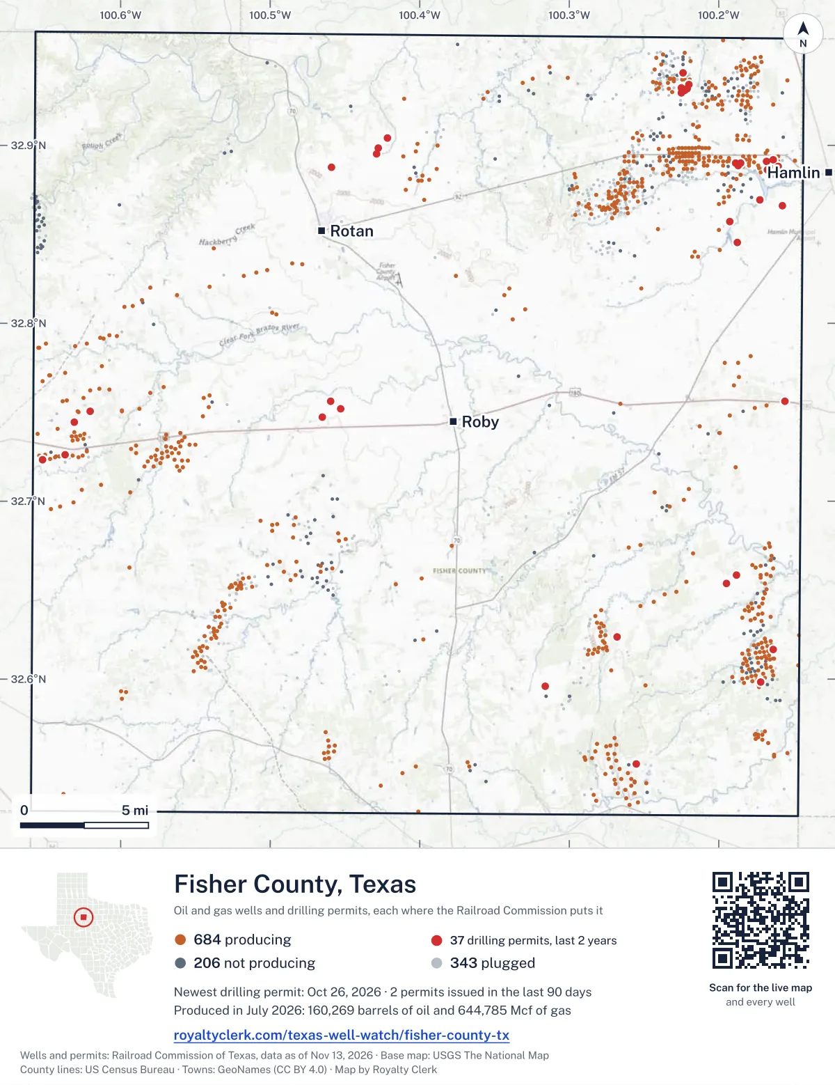
<a href="https://royaltyclerk.com/texas-well-watch/fisher-county-tx"><img src="https://royaltyclerk.com/maps/county-wells/fisher-county-tx.svg" alt="Map of Fisher County, Texas, with 1,233 oil and gas wells and 37 recent drilling locations as dots." width="1000" height="1298" loading="lazy" style="max-width:100%;height:auto;border:0"></a>
<p style="margin:4px 0 0;font-size:14px">Map: <a href="https://royaltyclerk.com/texas-well-watch/fisher-county-tx">Fisher County, Texas oil and gas wells</a> by Royalty Clerk, from Railroad Commission of Texas records</p>
The last twelve months
Month by month in Fisher County
| Month | Permits | Completions | First production |
|---|---|---|---|
| Oct 2026 | 1 | 1 | 0 |
| Sep 2026 | 1 | 0 | 0 |
| Aug 2026 | 1 | 2 | 0 |
| Jul 2026 | 5 | 1 | 0 |
| Jun 2026 | 0 | 0 | 1 |
| May 2026 | 2 | 0 | 0 |
| Apr 2026 | 1 | 2 | 0 |
| Mar 2026 | 2 | 0 | 0 |
| Feb 2026 | 1 | 2 | 0 |
| Jan 2026 | 0 | 1 | 1 |
| Dec 2025 | 0 | 1 | 0 |
| Nov 2025 | 1 | 0 | 0 |
Counted from November 15, 2025 to October 26, 2026, so the first and last months are partial. Source: Railroad Commission of Texas data sets.
Free, no sign-in
The newest drilling permits in Fisher County
| Issued | Lease and well | Operator | Drilling began | Depth, ft | API number | Coordinates | Permit |
|---|---|---|---|---|---|---|---|
| 2026-10-26 | KIMBER 1Hnew drill · horizontalR K Petroleum Corp.API 42-151-33404 · permit 091944632.74735, -100.465377,100 ft | R K Petroleum Corp. | |||||
| 2026-09-08 | ALPINE 1new drill · verticalClear Fork, IncorporatedAPI 42-151-33403 · permit 091833032.75063, -100.620414,800 ft | Clear Fork, Incorporated | |||||
| 2026-08-17 | RICE BROS. (CANYON) UNIT 201recompletion · verticalSojourner Drilling CorporationAPI 42-151-30319 · permit 091784432.89079, -100.168234,700 ft | Sojourner Drilling Corporation | |||||
| 2026-07-10 | MARY K. KENNEDY 4re-entry · verticalCoke Co. OperatingAPI 42-151-01775 · permit 091689232.93407, -100.220173,783 ft | Coke Co. Operating | |||||
| 2026-07-10 | MARY K. KENNEDY 3re-entry · verticalCoke Co. OperatingAPI 42-151-01774 · permit 091689132.93197, -100.220983,787 ft | Coke Co. Operating | |||||
| 2026-07-10 | MARY K. KENNEDY 2re-entry · verticalCoke Co. OperatingAPI 42-151-01773 · permit 091688632.93097, -100.223043,799 ft | Coke Co. Operating | |||||
| 2026-07-10 | CASSLE, H. O. 9re-entry · verticalCoke Co. OperatingAPI 42-151-01758 · permit 091687632.92959, -100.225133,797 ft | Coke Co. Operating | |||||
| 2026-07-10 | CASSLE, H. O. 5re-entry · verticalCoke Co. OperatingAPI 42-151-01754 · permit 091687532.93217, -100.225183,766 ft | Coke Co. Operating | |||||
| 2026-05-11 | CALLAN B 2Hnew drill · horizontalR K Petroleum Corp.API 42-151-33402 · permit 091539732.75197, -100.452687,100 ft | R K Petroleum Corp. | |||||
| 2026-05-08 | AJ CLARK 21-1 1new drill · verticalAmtex Energy, Inc.API 42-151-33400 · permit 091498432.59601, -100.31602drilling began 2026-08-17 · 6,200 ft | Amtex Energy, Inc. | |||||
| 2026-04-21 | HAMLIN TO HAWLEY #2 1new drill · verticalEnergy Transfer CompanyAPI 42-151-33401 · permit 091472432.75634, -100.15561400 ft | Energy Transfer Company | |||||
| 2026-03-12 | U-114 01new drill · verticalAtmos Energy Corp., Mid-Tex Div.API 42-151-33399 · permit 091378032.86620, -100.15763540 ft | Atmos Energy Corp., Mid-Tex Div. | |||||
| 2026-03-04 | CALLAN 1Hnew drill · horizontalR K Petroleum Corp.API 42-151-33398 · permit 091379732.75177, -100.452667,100 ft | R K Petroleum Corp. | |||||
| 2026-02-11 | ICA BAKER SWD 1Drecompletion · verticalIca Energy Operating, L.L.C.API 42-151-32973 · permit 091337532.89857, -100.42750drilling began 2014-01-14 · 3,764 ft | Ica Energy Operating, L.L.C. | |||||
| 2025-11-25 | GORDON A 1Rrecompletion · verticalGunn Oil CompanyAPI 42-151-00308 · permit 091187532.74442, -100.63077drilling began 2025-10-25 · 4,000 ft | Gunn Oil Company | |||||
| 2025-11-06 | SOJO-TOUCHSTONE 15recompletion · verticalL.c.s. Production CompanyAPI 42-151-33318 · permit 091163532.61659, -100.16375drilling began 2025-10-01 · 5,400 ft | L.c.s. Production Company | |||||
| 2025-10-16 | RADER 1new drill · verticalSojourner Drilling CorporationAPI 42-151-33397 · permit 091091832.85701, -100.19288drilling began 2025-10-26 · 6,000 ft | Sojourner Drilling Corporation | |||||
| 2025-10-01 | ELIZABETH RADER 1new drill · verticalSojourner Drilling CorporationAPI 42-151-33396 · permit 091075932.86952, -100.17279drilling began 2025-10-04 · 5,500 ft | Sojourner Drilling Corporation | |||||
| 2025-07-07 | RICE BROS. CANYON UNIT 806new drill · verticalSojourner Drilling CorporationAPI 42-151-33395 · permit 090905232.88815, -100.160335,500 ft | Sojourner Drilling Corporation | |||||
| 2025-07-07 | RICE BROS. (CANYON) UNIT 805new drill · verticalSojourner Drilling CorporationAPI 42-151-33394 · permit 090905032.88639, -100.16729drilling began 2025-07-16 · 5,500 ft | Sojourner Drilling Corporation | |||||
| 2025-07-02 | RICE BROS. (CANYON) UNIT 804new drill · verticalSojourner Drilling CorporationAPI 42-151-33393 · permit 090901932.89193, -100.16341drilling began 2025-08-01 · 5,500 ft | Sojourner Drilling Corporation | |||||
| 2025-05-29 | CALLAN '29' 1new drill · verticalR K Petroleum Corp.API 42-151-33392 · permit 090811832.75604, -100.45949drilling began 2026-06-30 · 7,000 ft | R K Petroleum Corp. | |||||
| 2025-04-23 | Y6 RANCH 1Hnew drill · horizontalBrowning Oil Company, Inc.API 42-151-33391 · permit 090752032.94083, -100.22418drilling began 2025-04-29 · 5,800 ft | Browning Oil Company, Inc. | |||||
| 2025-04-14 | HAMLIN UNIT 26new drill · verticalSojourner Drilling CorporationAPI 42-151-33390 · permit 090735932.89027, -100.18885drilling began 2025-06-27 · 5,000 ft | Sojourner Drilling Corporation | |||||
| 2025-04-08 | LIZZY 1Hnew drill · horizontalHadaway Consult and Engineer,llcAPI 42-151-33388 · permit 090714232.65834, -100.188446,000 ft | Hadaway Consult and Engineer,llc | |||||
| 2025-04-07 | BRYCE 1Hnew drill · horizontalHadaway Consult and Engineer,llcAPI 42-151-33387 · permit 090713632.65378, -100.195056,000 ft | Hadaway Consult and Engineer,llc | |||||
| 2025-04-04 | HENDERSON 1new drill · verticalVX Operating, LLCAPI 42-151-33389 · permit 090710332.55247, -100.25512drilling began 2025-04-14 · 7,000 ft | VX Operating, LLC | |||||
| 2025-03-27 | WICKHAM A 5reclass · verticalL.c.s. Production CompanyAPI 42-151-32698 · permit 090677332.59828, -100.17184drilling began 2008-05-31 · 4,997 ft | L.c.s. Production Company | |||||
| 2025-03-20 | PAXTON 1Hnew drill · horizontalHudspeth Operating, LLCAPI 42-151-33385 · permit 090658332.89500, -100.42861drilling began 2025-11-18 · 7,000 ft | Hudspeth Operating, LLC | |||||
| 2025-03-14 | COOLEY 1Hnew drill · verticalHudspeth Operating, LLCAPI 42-151-33386 · permit 090650932.88778, -100.45917drilling began 2025-11-27 · 7,000 ft | Hudspeth Operating, LLC | |||||
| 2025-03-13 | KINGS CANYON 30-47 2Hrecompletion · horizontalBrowning Oil Company, Inc.API 42-151-33384 · permit 090650232.72629, -100.63708drilling began 2025-04-02 · 6,900 ft | Browning Oil Company, Inc. | |||||
| 2025-03-11 | MCNEELY 1Hnew drill · horizontalIca Energy Operating, L.L.C.API 42-151-33383 · permit 090646432.90407, -100.42144drilling began 2025-03-24 · 7,000 ft | Ica Energy Operating, L.L.C. | |||||
| 2025-02-03 | BADLANDS 48 2Hnew drill · horizontalBrowning Oil Company, Inc.API 42-151-33381 · permit 090547632.72319, -100.65252drilling began 2025-03-12 · 6,700 ft | Browning Oil Company, Inc. | |||||
| 2025-01-30 | HAMLIN UNIT 25new drill · verticalSojourner Drilling CorporationAPI 42-151-33382 · permit 090552932.88860, -100.18715drilling began 2025-02-05 · 5,000 ft | Sojourner Drilling Corporation | |||||
| 2025-01-23 | BULL 10-10 1Hnew drill · horizontalCholla Petroleum, Inc.API 42-151-33379 · permit 090533132.62377, -100.26822drilling began 2025-02-03 · 7,999 ft | Cholla Petroleum, Inc. | |||||
| 2025-01-23 | U-116 1new drill · verticalAtmos Energy Corp., Mid-Tex Div.API 42-151-33380 · permit 090496232.84560, -100.18759500 ft | Atmos Energy Corp., Mid-Tex Div. | |||||
| 2024-11-26 | W W HOLMAN 13new drill · verticalSojourner Drilling CorporationAPI 42-151-33378 · permit 090425132.89001, -100.18526drilling began 2025-01-16 · 5,000 ft | Sojourner Drilling Corporation | |||||
| 2024-11-13 | U22-03 UNIT 1new drill · verticalAtmos Energy Corp., Mid-Tex Div.API 42-151-33377 · permit 090365732.80428, -100.17332430 ft | Atmos Energy Corp., Mid-Tex Div. | |||||
| 2024-10-24 | TENNESSEE JED 1Hnew drill · horizontalClear Fork, IncorporatedAPI 42-151-33376 · permit 090351132.70059, -100.223406,000 ft | Clear Fork, Incorporated | |||||
| 2024-10-17 | OOLITIC TIGER SWD 1new drill · verticalHadaway Consult and Engineer,llcAPI 42-151-33375 · permit 090332132.65845, -100.188476,000 ft | Hadaway Consult and Engineer,llc | |||||
| 2024-09-30 | BRADFORD 2new drill · verticalVX Operating, LLCAPI 42-151-33373 · permit 090282732.54234, -100.25607drilling began 2024-10-02 · 7,000 ft | VX Operating, LLC | |||||
| 2024-09-27 | BRADFORD 1recompletion · verticalVX Operating, LLCAPI 42-151-33275 · permit 090282032.54201, -100.25641drilling began 2024-08-16 · 5,835 ft | VX Operating, LLC | |||||
| 2024-09-23 | JACK STRAW 43-46 1Hnew drill · horizontalClear Fork, IncorporatedAPI 42-151-33372 · permit 090275432.70477, -100.24298drilling began 2024-10-16 · 6,000 ft | Clear Fork, Incorporated | |||||
| 2024-08-29 | WELCH 8new drill · verticalL.c.s. Production CompanyAPI 42-151-33371 · permit 090221432.60033, -100.18401drilling began 2024-09-12 · 5,990 ft | L.c.s. Production Company | |||||
| 2024-07-29 | THOMAS SWD 1new drill · verticalCholla Petroleum, Inc.API 42-151-33368 · permit 090151232.67064, -100.21709drilling began 2024-08-26 · 7,999 ft | Cholla Petroleum, Inc. | |||||
| 2024-07-26 | BERTHA 28-6 1Hnew drill · horizontalBrowning Oil Company, Inc.API 42-151-33370 · permit 090153832.67525, -100.25216drilling began 2024-08-04 · 7,500 ft | Browning Oil Company, Inc. | |||||
| 2024-07-23 | INTO THE STORM 1Hnew drill · horizontalCholla Petroleum, Inc.API 42-151-33367 · permit 090144332.67065, -100.21699drilling began 2024-08-26 · 7,999 ft | Cholla Petroleum, Inc. | |||||
| 2024-07-19 | WELCH 20re-entry · verticalL.c.s. Production CompanyAPI 42-151-01447 · permit 090140032.60247, -100.183654,525 ft | L.c.s. Production Company | |||||
| 2024-07-18 | JUMBO 1Hnew drill · horizontalCholla Petroleum, Inc.API 42-151-33366 · permit 090135232.65487, -100.22142drilling began 2024-09-25 · 7,999 ft | Cholla Petroleum, Inc. | |||||
| 2024-07-15 | NORTH WICKHAM 1recompletion · verticalL.c.s. Production CompanyAPI 42-151-32808 · permit 090121232.60677, -100.17160drilling began 2024-05-29 · 4,770 ft | L.c.s. Production Company |
These are the newest 50 of 95 permits on file for Fisher County. The rest follow, 50 to a page.
A permit is permission to drill, not a well. Source: Railroad Commission of Texas drilling permit files.
Year by year
Drilling permits issued in Fisher County, by year
| Year | Permits issued |
|---|---|
| 2026 so far | 14 |
| 2025 | 22 |
| 2024 | 38 |
| 2023 | 18 |
| 2022 | 2 |
| 2019 | 1 |
Counted from the permit files we hold, which start in 2019; that first year may be partial. Source: Railroad Commission of Texas drilling permit files.
The latest
The most recent records
| Date | What, who and where |
|---|---|
| 2026-10-26 | Permit issued: R K Petroleum Corp.KIMBER · A-87 · permit 0919446 |
| 2026-10-07 | Completed: Sojourner Drilling CorporationHOLMAN · A-383 |
| 2026-09-08 | Permit issued: Clear Fork, IncorporatedALPINE · A-198 · permit 0918330 |
| 2026-08-22 | Completed: R K Petroleum Corp.CALLAN '29' · A-89 · permit 0908118 |
| 2026-08-17 | Permit issued: Sojourner Drilling CorporationRICE BROS. (CANYON) UNIT · A-391 · permit 0917844 |
| 2026-08-06 | Completed: Sojourner Drilling CorporationRICE BROS. CANYON UNIT · A-391 · permit 0909052 |
| 2026-07-30 | Completed: Sojourner Drilling CorporationRICE BROS. (CANYON) UNIT · A-391 · permit 0909050 |
| 2026-07-10 | Permit issued: Coke Co. OperatingMARY K. KENNEDY · A-1422 · permit 0916892 |
| 2026-07-10 | Permit issued: Coke Co. OperatingMARY K. KENNEDY · A-1422 · permit 0916891 |
| 2026-07-10 | Permit issued: Coke Co. OperatingMARY K. KENNEDY · A-1422 · permit 0916886 |
| 2026-07-10 | Permit issued: Coke Co. OperatingCASSLE, H. O. · A-1422 · permit 0916875 |
| 2026-07-10 | Permit issued: Coke Co. OperatingCASSLE, H. O. · A-1422 · permit 0916876 |
| 2026-06-01 | First production: Sojourner Drilling CorporationWeasley · A-430 · permit 0910918 |
| 2026-05-11 | Permit issued: R K Petroleum Corp.CALLAN B · A-89 · permit 0915397 |
| 2026-05-08 | Permit issued: Amtex Energy, Inc.AJ CLARK 21-1 · A-320 · permit 0914984 |
Coming up
First checks coming due in Fisher County
- RICE BROS. CANYON UNIT, Sojourner Drilling Corporationby December 29, 2026
- HOLMAN, Sojourner Drilling Corporationby February 28, 2027
Follow it
Watch Fisher County, or one abstract
What do you want to follow?
Where the land is. Your deed or lease names it.
For example A-1119, or Bush, or T&P 38. Your deed or the tax bill has it.
Other counties
Drilling activity in other counties
Related
Related
- ToolTexas well watchPermit, completion, first production and when the first check is due.
- ToolIs this buyout offer fair?The offer as months of your income, what the acres mean, and the questions to ask.
- ToolIs this lease offer good?Bonus and royalty against the county, and a scan of the lease's clauses.
- Texas dataTexas operator changesWho took over whose leases in the last 24 months.
- ToolLate payment interestDeadlines and the interest a late payment earns.
- Texas dataTexas oil and gas atlas254 counties, every lease, operator and field.
FAQ
Questions people ask
How many wells were permitted in Fisher County in the last year?
The Railroad Commission issued 15 drilling permits in Fisher County in the twelve months to October 26, 2026, and recorded 10 completions and 2 first-production reports. A permit is permission to drill, not a well.
How do I get an alert when a permit is issued near my land in Fisher County?
Choose your abstract on this page, or the whole county, and sign in. You get one email a week, only when something new is recorded after you sign up. The alert says whether an event is on an interest in your Mineral File, on a place you follow, or only nearby.
When is my first royalty check due after a new well?
Natural Resources Code section 91.402(a) says on or before 120 days after the end of the month of first sale of production from the well. The state's first-production month is the closest public marker, so the date on this page is the earliest, not a certainty.
Got a new well on your land?
The first check is due within 120 days after the end of the month of first sale.
Sources
Primary sources, opened on 29 September 2026. Statute text is the current version on statutes.capitol.texas.gov.