
RRC operator 159500
Clear Fork, Incorporated
Clear Fork, Incorporated reported 322,246 barrels of oil and 1.2 million mcf of gas in the last 12 months.
Operator dossier
- Producing leases
- 34of 81 on record
- Counties
- 7
- Biggest county
- Fisher County
- Biggest field
- Sylvester, East (Strawn)
Get checks from Clear Fork, Incorporated?
A family member owned minerals here?
Search their name: a family member who owned minerals hereWhere they work
fewermore
- Gas, last 12 months
- 1,213,585 mcf
- Fields
- 20
- Data through
- Aug 2026
- Leases on record
- 81
Where Clear Fork, Incorporated has wells
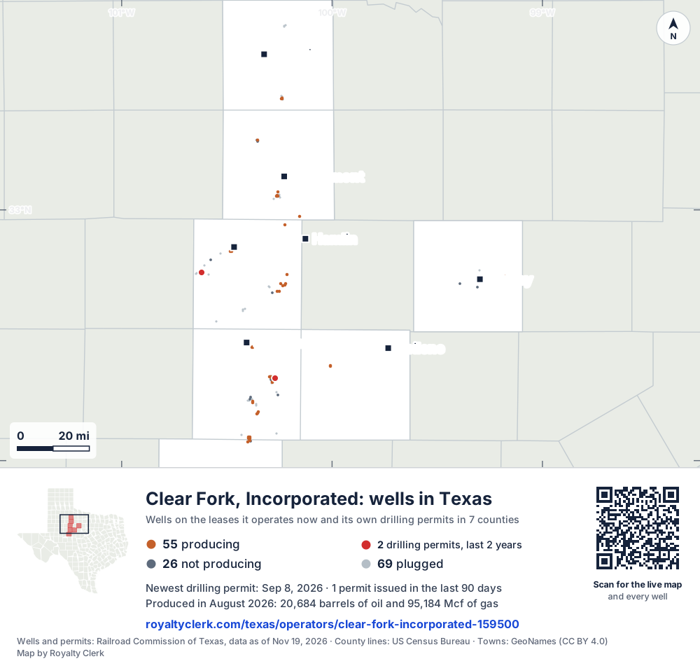
- Drilling locations2Permits issued in the last two years
- Producing wells55On a lease reporting production now
- Not producing26Shut in, inactive or no lease on record
- Plugged69The state's wellbore record says plugged
Each dot is a well on a lease Clear Fork, Incorporated operates now, where the Railroad Commission's map puts it, or one of its drilling permits of the last 24 months. Wells of other operators are not on this map. The picture is about 193 miles across. The white counties are the ones with a well or drilling permit of its own on the map. Sources: Railroad Commission of Texas well layers and drilling permit files, US Census Bureau county outlines, town points from GeoNames (CC BY 4.0).
Use this map on your site
You may show this map on any site, unchanged. Keep the credit line and its link to Royalty Clerk under the map. The picture updates by itself as the state records new wells and permits.
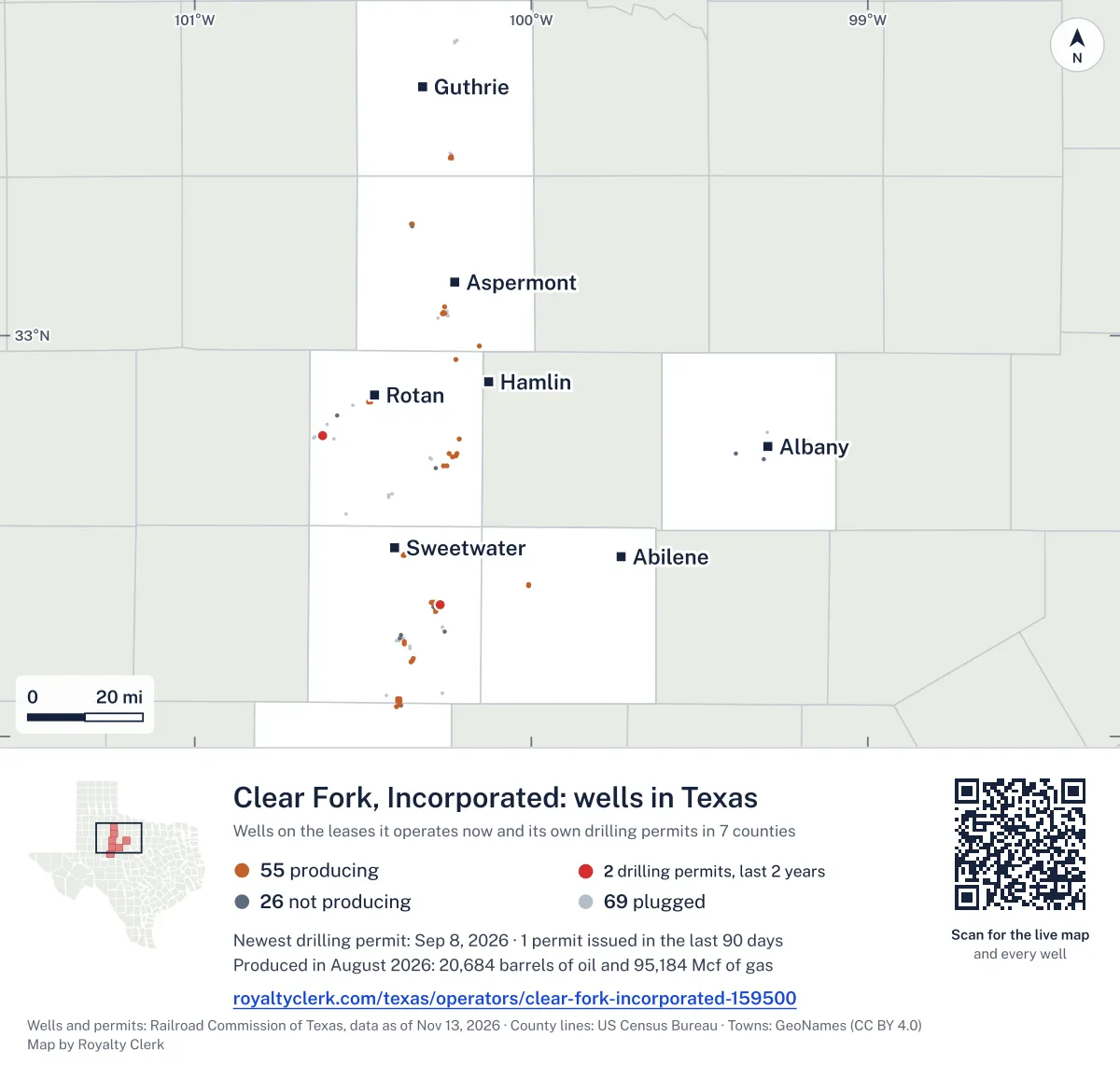
<a href="https://royaltyclerk.com/texas/operators/clear-fork-incorporated-159500"><img src="https://royaltyclerk.com/maps/operator-wells/clear-fork-incorporated-159500.svg" alt="Map of the wells of Clear Fork, Incorporated in Texas: 150 wells and 2 recent drilling locations, in a picture about 193 miles across." width="1000" height="951" loading="lazy" style="max-width:100%;height:auto;border:0"></a>
<p style="margin:4px 0 0;font-size:14px">Map: <a href="https://royaltyclerk.com/texas/operators/clear-fork-incorporated-159500">Oil and gas wells of Clear Fork, Incorporated in Texas</a> by Royalty Clerk, from Railroad Commission of Texas records</p>
How Clear Fork's oil fell after its 2022 high
Clear Fork, Incorporated built most of its output around one county and one field. Fisher County and the Sylvester, East (Strawn) field carry most of its gas. Oil made more of its output than gas, counted in barrels of oil equivalent, in every full calendar year from 2020 to 2025. Its biggest full calendar year was 2022, when oil reached 3,131,638 barrels. Oil then fell to 1,558,864 barrels in 2023 and to 296,812 in 2024. Oil rose to 455,458 barrels in 2025.
Most of its gas goes to a plant. Over the last 12 months, 96.5% of its gas went to a plant. Et Gathering & Processing LLC is the main buyer, listed on 8 of its leases.
It handed one lease to T J Water Works, A Texas LLC within the last 24 months. It has 177 wells on its leases, 100 of them active and 18 horizontal. Its most recent drilling permit is from 2026.
Not a forecast, not reserves.
Key moments
- 2022Biggest full calendar year: oil 3,131,638 barrels, gas 6,576,598 mcf.
- 2023Oil fell to 1,558,864 barrels after the 2022 high.
- 2024Oil fell to 296,812 barrels; gas fell to 851,363 mcf.
- 2024Five drilling permits filed on its leases in 2024.
- 2025Oil rose to 455,458 barrels; gas rose to 1,354,833 mcf.
If you own here
- Who buys my oil and gas?
Et Gathering & Processing LLC is listed as buyer on 8 leases; the tool lists buyers for your lease and since when.
- Why is my royalty check lower?
Oil output fell 19.5% in the last 12 months; the tool splits a check drop into volume, price, deductions and share.
- Gas royalty calculator
96.5% of its gas went to a plant over the last 12 months; the tool shows where each cost comes off.
Questions owners ask
- How much has Clear Fork's oil output changed since 2022?
- Oil was 3,131,638 barrels in 2022, 1,558,864 barrels in 2023, 296,812 barrels in 2024 and 455,458 barrels in 2025. Each yearly total is a full calendar year. The 2026 figures cover only the first seven months, so they are not compared with full years. Why is my royalty check lower?
- Who buys this operator's gas?
- Et Gathering & Processing LLC is listed as a buyer on 8 of its leases. Scurry Midstream, LLC is listed on 4 leases. Targa Midstream Services LLC and Clear Fork, Incorporated are each listed on 1 lease. Who buys my oil and gas?
- What happens to this operator's gas after it leaves the wells?
- Over the last 12 months, 96.5% of its gas went to a plant. Lease fuel used 1.3%. Vented or flared gas was 2.2%. The gas royalty calculator shows where each cost comes off. Gas royalty calculator
- Which lease was handed to another company?
- T J Water Works, A Texas LLC took over one lease from Clear Fork within the last 24 months. Clear Fork still holds 81 leases in state records, and 34 of them are producing now.
Related pages
- Fisher County
Ten producing leases here, and 93.7% of this operator's gas comes from the county.
- Sylvester, East (Strawn)
Eight producing leases in this field carry most of the operator's gas.
- Nolan County
Fourteen producing leases, the most of any county where this operator produces.
- Weir, W. C. -A-
The operator's oldest producing lease, with reports back to January 1993.
- Stonewall County
Four producing leases in this county, with no gas output reported.
From the state's records through July 2026.
How its oil and gas moved over five years
Oil output from Clear Fork, Incorporated fell 28% over the last 12 months
322k bbl through Aug 2026, against 446k bbl a year earlier. Peak Aug 2022: 309k bbl.
Gas output from Clear Fork, Incorporated fell 8% over the last 12 months
1.2M mcf through Aug 2026, against 1.3M mcf a year earlier. Peak Sep 2022: 662k mcf.
SourceTexas Railroad Commission Production Data Query, operator 159500, through Aug 2026, file dated Oct 20, 2026.
Which leases Clear Fork runs, biggest first
Under each volume: change on the year before.
77,622bbl oiln/a
43,066bbl oiln/a
31,847bbl oil−61%
24,194bbl oil+8%
20,371bbl oiln/a
19,910bbl oil−23%
18,260bbl oil−71%
11,151bbl oil+1%
10,237bbl oil−48%
9,166bbl oil−28%
8,523bbl oil+10%
7,507bbl oil−10%
5,278bbl oiln/a
5,250bbl oil−26%
4,211bbl oil+2%
3,067bbl oil−23%
2,708bbl oil−18%
2,320bbl oil−28%
2,165bbl oil−19%
1,945bbl oil+10%
1,941bbl oil−16%
1,674bbl oil0%
1,416bbl oil−29%
1,406bbl oil−11%
1,098bbl oil−9%
Showing 25 of 34, ranked by output value.
SourceTexas Railroad Commission Production Data Query.
Which counties and fields Clear Fork produces in
Counties, by Clear Fork, Incorporated oil
Fisher County leads
Fields, by Clear Fork, Incorporated oil
Sylvester, East (Strawn) leads
- Sylvester, East (Strawn)8 leases · District 7B · Field 87813500244kbbl
- Garden City, S. (Wolfcamp)2 leases · District 08 · Field 3399850018.8kbbl
- Evb, S. (Caddo Conglomerate)1 lease · District 7B · Field 2703605011.2kbbl
- Evb (4800 Canyon Sand)2 leases · District 7B · Field 2703287510.5kbbl
- Frankirk, N. (Canyon Reef)1 lease · District 7B · Field 326555007,507bbl
- Lazarus (Strawn)2 leases · District 7B · Field 525107006,376bbl
- Look Back (Miss-Cambrian)2 leases · District 7B · Field 548405003,183bbl
- Parsons (Ellenburger)1 lease · District 7B · Field 694571003,067bbl
Drilling permits Clear Fork has filed recently
ALPINE #1
new drill · Clear Fork, Incorporated · Fisher County
Permit 0918330 · Sep 8, 2026
BOYD, C.E. 59 LCS #759R
recompletion · Clear Fork, Incorporated · Nolan County
Permit 0906708 · Mar 20, 2025
TENNESSEE JED #1H
new drill · horizontal · Clear Fork, Incorporated · Fisher County
Permit 0903511 · Oct 24, 2024
JACK STRAW 43-46 #1H
new drill · horizontal · Clear Fork, Incorporated · Fisher County
Permit 0902754 · Sep 23, 2024
BRAZOS 25-26 #1WD
recompletion · Clear Fork, Incorporated · Fisher County
Permit 0900150 · Jun 13, 2024
CASEY JONES #1H
recompletion · horizontal · Clear Fork, Incorporated · Fisher County
Permit 0898535 · Apr 4, 2024
Where the gas of Clear Fork, Incorporated went
- Plants
- 98%
- Pipelines
- 0.0%
- Lease fuel
- <0.1%
- Flared or vented
- 2.3%
SourceTexas Railroad Commission Production Data Query, last 12 months. What the codes mean
Clear Fork, Incorporated address and phone number
This is the mailing address and phone Clear Fork, Incorporated filed with the Texas Railroad Commission. It is the company’s address of record with the state. It can be a regulatory office and not the desk that pays royalties, so a letter about a payment should name the owner relations or division order department, your owner number and the lease name from your stub.
Mailing address
Clear Fork, IncorporatedPO Box 3095
Abilene, TX 79604
Phone
State filing
RRC operator 159500 · P-5 status: Active · last filing received Feb 4, 2026
Writing about a missing or stopped check? See what to ask first or open the company record for its state registration and who buys its oil and gas.
SourceTexas Railroad Commission, P-5 Organization data, file dated Oct 22, 2026. Royalty Clerk is not affiliated with Clear Fork, Incorporated.