
Frio County, Texas
Frio County drilling permits: what the state recorded
- 73drilling permits
- 43completions
- 13first-production reports
- in the last twelve months
Wells by coordinates
Oil wells and drilling locations in Frio County
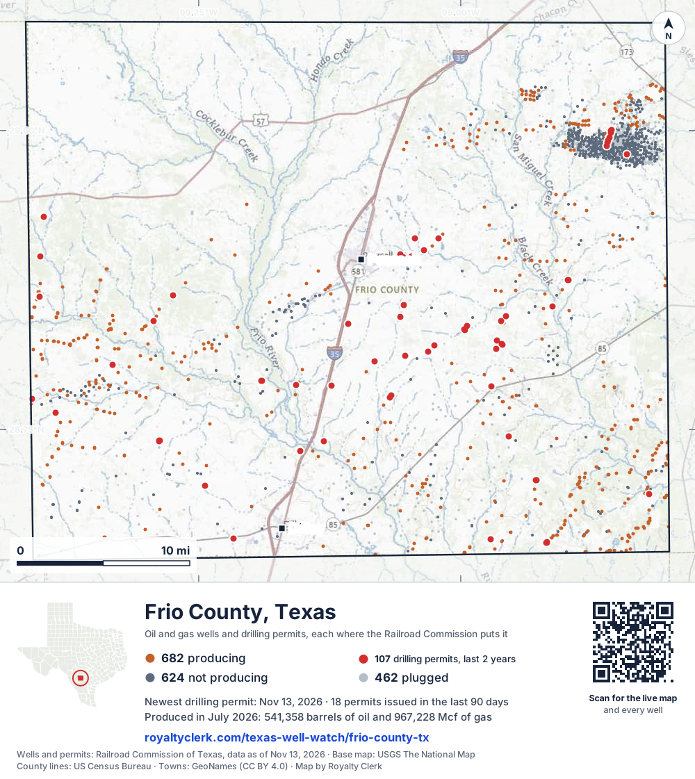
- Drilling locations107Permits issued in the last two years
- Producing wells682On a lease reporting production now
- Not producing624Shut in, inactive or no lease on record
- Plugged462The state's wellbore record says plugged
Sources: Railroad Commission of Texas well layers and permit files, US Census Bureau county outline, town points from GeoNames (CC BY 4.0), base map from USGS The National Map. A dot is a surface location; a horizontal well runs a mile or more from it.
1,768 wells with a location on the state's map and 107 drilling locations permitted in the last 24 months, each where the Railroad Commission puts it.
A permit is not a well.
Frio County is one of the 27 counties of the Eagle Ford Shale
Wells near each town in Frio County
Wells within 10 miles of each town, on either side of the county line.
Use this map on your site
You may show this map on any site, unchanged. Keep the credit line and its link to Royalty Clerk under the map. The picture updates by itself as the state records new wells and permits.
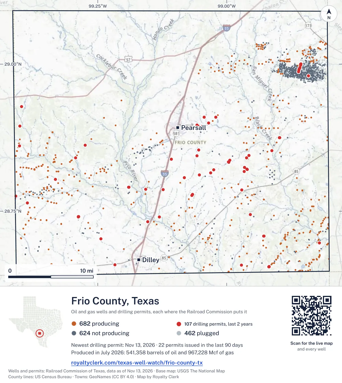
<a href="https://royaltyclerk.com/texas-well-watch/frio-county-tx"><img src="https://royaltyclerk.com/maps/county-wells/frio-county-tx.svg" alt="Map of Frio County, Texas, with 1,768 oil and gas wells and 107 recent drilling locations as dots." width="1000" height="1121" loading="lazy" style="max-width:100%;height:auto;border:0"></a>
<p style="margin:4px 0 0;font-size:14px">Map: <a href="https://royaltyclerk.com/texas-well-watch/frio-county-tx">Frio County, Texas oil and gas wells</a> by Royalty Clerk, from Railroad Commission of Texas records</p>
The last twelve months
Month by month in Frio County
| Month | Permits | Completions | First production |
|---|---|---|---|
| Nov 2026 | 10 | 0 | 0 |
| Oct 2026 | 3 | 2 | 0 |
| Sep 2026 | 5 | 2 | 0 |
| Aug 2026 | 5 | 5 | 1 |
| Jul 2026 | 5 | 6 | 0 |
| Jun 2026 | 13 | 5 | 2 |
| May 2026 | 4 | 4 | 1 |
| Apr 2026 | 5 | 3 | 0 |
| Mar 2026 | 5 | 4 | 0 |
| Feb 2026 | 9 | 5 | 3 |
| Jan 2026 | 0 | 2 | 2 |
| Dec 2025 | 6 | 2 | 4 |
| Nov 2025 | 3 | 3 | 0 |
Counted from November 15, 2025 to November 13, 2026, so the first and last months are partial. Source: Railroad Commission of Texas data sets.
Free, no sign-in
The newest drilling permits in Frio County
| Issued | Lease and well | Operator | Drilling began | Depth, ft | API number | Coordinates | Permit |
|---|---|---|---|---|---|---|---|
| 2026-11-13 | DOUBLE RINGER 101HZ 101HZnew drill · horizontalJavelin Energy Partners Mgmt LLCAPI 42-163-34454 · permit 091973728.69592, -98.8203214,000 ft | Javelin Energy Partners Mgmt LLC | |||||
| 2026-11-13 | BLAZING SADDLES A111VWnew drill · verticalFormentera Operations LLCAPI 42-163-34460 · permit 092003928.78600, -98.970455,800 ft | Formentera Operations LLC | |||||
| 2026-11-10 | DOUBLE RINGER 101HB 101HBnew drill · horizontalJavelin Energy Partners Mgmt LLCAPI 42-163-34451 · permit 091972028.69595, -98.8204514,000 ft | Javelin Energy Partners Mgmt LLC | |||||
| 2026-11-10 | SENDERO-UNIT-B S736Hnew drill · horizontalFormentera Operations LLCAPI 42-163-34459 · permit 091994628.82117, -98.9601210,500 ft | Formentera Operations LLC | |||||
| 2026-11-06 | SENDERO-UNIT-B S734Hnew drill · horizontalFormentera Operations LLCAPI 42-163-34458 · permit 091994528.82111, -98.9601810,500 ft | Formentera Operations LLC | |||||
| 2026-11-05 | DOUBLE RINGER 101HA 101HAnew drill · horizontalJavelin Energy Partners Mgmt LLCAPI 42-163-34452 · permit 091971828.69596, -98.8205114,000 ft | Javelin Energy Partners Mgmt LLC | |||||
| 2026-11-05 | JULIAN S731Hnew drill · horizontalFormentera Operations LLCAPI 42-163-34457 · permit 091988328.70322, -99.2439911,500 ft | Formentera Operations LLC | |||||
| 2026-11-05 | EMPIRE-UNIT-B N733Hnew drill · horizontalFormentera Operations LLCAPI 42-163-34456 · permit 091988228.70324, -99.2440811,500 ft | Formentera Operations LLC | |||||
| 2026-11-05 | EMPIRE-UNIT-A N731Hnew drill · horizontalFormentera Operations LLCAPI 42-163-34455 · permit 091988128.70326, -99.2441711,500 ft | Formentera Operations LLC | |||||
| 2026-11-03 | TREATY OAK 701Hnew drill · horizontalTexas American Resources CompanyAPI 42-163-34450 · permit 091956328.87475, -98.8973811,000 ft | Texas American Resources Company | |||||
| 2026-10-16 | COHN 1Anew drill · verticalCentral Gulf Petroleum IncAPI 42-163-34448 · permit 091927028.98036, -98.841423,850 ft | Central Gulf Petroleum Inc | |||||
| 2026-10-07 | MOJOSA RANCH 706Hnew drill · horizontalTexas American Resources CompanyAPI 42-163-34447 · permit 091909728.85405, -99.0540111,000 ft | Texas American Resources Company | |||||
| 2026-10-07 | MOJOSA RANCH 705Hnew drill · horizontalTexas American Resources CompanyAPI 42-163-34446 · permit 091909628.85399, -99.0540711,000 ft | Texas American Resources Company | |||||
| 2026-09-23 | ROCKY-UNIT S734Hnew drill · horizontalFormentera Operations LLCAPI 42-163-34445 · permit 091881328.83863, -99.1071010,000 ft | Formentera Operations LLC | |||||
| 2026-09-23 | ROCKY-UNIT S732Hnew drill · horizontalFormentera Operations LLCAPI 42-163-34444 · permit 091881228.83857, -99.1071610,000 ft | Formentera Operations LLC | |||||
| 2026-09-23 | ROCKY-UNIT S730Hnew drill · horizontalFormentera Operations LLCAPI 42-163-34443 · permit 091881128.83851, -99.1072310,000 ft | Formentera Operations LLC | |||||
| 2026-09-11 | NERO-UNIT-B S733Hnew drill · horizontalFormentera Operations LLCAPI 42-163-34442 · permit 091846728.79063, -99.1899410,500 ft | Formentera Operations LLC | |||||
| 2026-09-10 | NEAL 2new drill · verticalMB Energy, LLCAPI 42-163-34441 · permit 091845728.89442, -99.054884,300 ft | MB Energy, LLC | |||||
| 2026-08-19 | NEXT IN LINE-UNIT N734Hnew drill · horizontalFormentera Operations LLCAPI 42-163-34438 · permit 091794028.85304, -98.91216drilling began 2026-09-06 · 10,500 ft | Formentera Operations LLC | |||||
| 2026-08-19 | NEXT IN LINE-UNIT N731Hnew drill · horizontalFormentera Operations LLCAPI 42-163-34437 · permit 091793928.85296, -98.91216drilling began 2026-09-03 · 10,000 ft | Formentera Operations LLC | |||||
| 2026-08-19 | NERO-UNIT-A S731Hnew drill · horizontalFormentera Operations LLCAPI 42-163-34439 · permit 091793728.79060, -99.1898510,500 ft | Formentera Operations LLC | |||||
| 2026-08-19 | FLAVIA-UNIT N731Hnew drill · horizontalFormentera Operations LLCAPI 42-163-34440 · permit 091793628.79065, -99.1900310,500 ft | Formentera Operations LLC | |||||
| 2026-08-12 | NEPTUNE A211VWnew drill · verticalFormentera Operations LLCAPI 42-163-34436 · permit 091776328.78740, -99.157295,500 ft | Formentera Operations LLC | |||||
| 2026-07-27 | OPPENHEIMER C 3Hnew drill · horizontalRosewood Resources, Inc.API 42-163-34434 · permit 091732328.86197, -99.274527,000 ft | Rosewood Resources, Inc. | |||||
| 2026-07-22 | TWIN CREEKS A 1Hnew drill · horizontalRosewood Resources, Inc.API 42-163-34435 · permit 091732428.86217, -99.27447drilling began 2026-08-26 · 7,000 ft | Rosewood Resources, Inc. | |||||
| 2026-07-22 | OPPENHEIMER B 2Hnew drill · horizontalRosewood Resources, Inc.API 42-163-34433 · permit 091732128.86204, -99.27450drilling began 2026-08-24 · 7,000 ft | Rosewood Resources, Inc. | |||||
| 2026-07-22 | OPPENHEIMER A 1Hnew drill · horizontalRosewood Resources, Inc.API 42-163-34432 · permit 091732028.86211, -99.27448drilling began 2026-08-25 · 7,000 ft | Rosewood Resources, Inc. | |||||
| 2026-07-10 | BORDOVSKY J S 'A' 191 Anew drill · verticalCentral Gulf Petroleum IncAPI 42-163-34431 · permit 091714029.00032, -98.855983,850 ft | Central Gulf Petroleum Inc | |||||
| 2026-06-26 | JOSEY WALES C211VWnew drill · verticalFormentera Operations LLCAPI 42-163-34430 · permit 091673228.77837, -99.066275,900 ft | Formentera Operations LLC | |||||
| 2026-06-24 | BORDOVSKY J S 'A' 192Anew drill · verticalCentral Gulf Petroleum IncAPI 42-163-34429 · permit 091577228.99967, -98.856353,800 ft | Central Gulf Petroleum Inc | |||||
| 2026-06-19 | HANCOCK SOUTH WEST B2 B 2Hnew drill · horizontalRosewood Resources, Inc.API 42-163-34427 · permit 091643228.89486, -99.40091drilling began 2026-07-03 · 6,000 ft | Rosewood Resources, Inc. | |||||
| 2026-06-18 | BUTCH CASSIDY B111VWnew drill · verticalFormentera Operations LLCAPI 42-163-34428 · permit 091655228.83691, -98.994075,500 ft | Formentera Operations LLC | |||||
| 2026-06-18 | HANCOCK NORTH WEST A2 A 2Hnew drill · horizontalRosewood Resources, Inc.API 42-163-34425 · permit 091643028.92807, -99.39789drilling began 2026-07-22 · 6,000 ft | Rosewood Resources, Inc. | |||||
| 2026-06-17 | HANCOCK SOUTH WEST B1 B 1Hnew drill · horizontalRosewood Resources, Inc.API 42-163-34426 · permit 091643128.89484, -99.40083drilling began 2026-07-02 · 6,000 ft | Rosewood Resources, Inc. | |||||
| 2026-06-17 | HANCOCK NORTH WEST A1 A 1Hnew drill · horizontalRosewood Resources, Inc.API 42-163-34424 · permit 091642928.92807, -99.39797drilling began 2026-07-22 · 6,000 ft | Rosewood Resources, Inc. | |||||
| 2026-06-16 | BANRICH 3Hnew drill · horizontalRosewood Resources, Inc.API 42-163-34423 · permit 091641528.86122, -99.40195drilling began 2026-07-04 · 6,200 ft | Rosewood Resources, Inc. | |||||
| 2026-06-16 | BANRICH 2Hnew drill · horizontalRosewood Resources, Inc.API 42-163-34422 · permit 091641428.86129, -99.40193drilling began 2026-07-04 · 6,200 ft | Rosewood Resources, Inc. | |||||
| 2026-06-16 | BANRICH 1Hnew drill · horizontalRosewood Resources, Inc.API 42-163-34421 · permit 091641328.86135, -99.40191drilling began 2026-07-02 · 6,200 ft | Rosewood Resources, Inc. | |||||
| 2026-06-12 | NEAL 2new drill · verticalArete Operating Company, LLCAPI 42-163-34420 · permit 091636028.89494, -99.046724,200 ft | Arete Operating Company, LLC | |||||
| 2026-06-09 | OLD LAREDO-UNIT-B S738Hnew drill · horizontalFormentera Operations LLCAPI 42-163-34418 · permit 091625028.77695, -99.06778drilling began 2026-08-17 · 11,200 ft | Formentera Operations LLC | |||||
| 2026-06-09 | OLD LAREDO-UNIT-A S735Hnew drill · horizontalFormentera Operations LLCAPI 42-163-34419 · permit 091625128.77689, -99.06785drilling began 2026-08-15 · 11,200 ft | Formentera Operations LLC | |||||
| 2026-05-22 | TIBER D411VWnew drill · verticalFormentera Operations LLCAPI 42-163-34417 · permit 091579328.74010, -99.287505,500 ft | Formentera Operations LLC | |||||
| 2026-05-12 | REPUBLIC S731Hnew drill · horizontalFormentera Operations LLCAPI 42-163-34416 · permit 091549928.74094, -99.28740drilling began 2026-07-03 · 11,300 ft | Formentera Operations LLC | |||||
| 2026-05-12 | REPUBLIC S723Hnew drill · horizontalFormentera Operations LLCAPI 42-163-34415 · permit 091549728.74091, -99.28731drilling began 2026-06-29 · 11,300 ft | Formentera Operations LLC | |||||
| 2026-05-12 | CAESAR-UNIT N731HPnew drill · horizontalFormentera Operations LLCAPI 42-163-34414 · permit 091549528.74095, -99.28749drilling began 2026-08-08 · 11,300 ft | Formentera Operations LLC | |||||
| 2026-04-13 | LUCILLE-STX-UNIT-B S736Hnew drill · horizontalFormentera Operations LLCAPI 42-163-34413 · permit 091474428.84102, -98.96137drilling began 2026-06-19 · 10,500 ft | Formentera Operations LLC | |||||
| 2026-04-13 | LUCILLE-STX-UNIT-B S727Hnew drill · horizontalFormentera Operations LLCAPI 42-163-34412 · permit 091474328.84485, -98.9569810,500 ft | Formentera Operations LLC | |||||
| 2026-04-13 | LUCILLE-STX-UNIT-A S724Hnew drill · horizontalFormentera Operations LLCAPI 42-163-34411 · permit 091474128.84096, -98.96144drilling began 2026-06-21 · 10,500 ft | Formentera Operations LLC | |||||
| 2026-04-13 | GAMBLER-STX-UNIT N736Hnew drill · horizontalFormentera Operations LLCAPI 42-163-34410 · permit 091474028.84474, -98.95712drilling began 2026-06-16 · 10,000 ft | Formentera Operations LLC | |||||
| 2026-04-13 | GAMBLER-STX-UNIT N727Hnew drill · horizontalFormentera Operations LLCAPI 42-163-34409 · permit 091473928.84480, -98.95705drilling began 2026-06-20 · 10,000 ft | Formentera Operations LLC |
These are the newest 50 of 129 permits on file for Frio County. The rest follow, 50 to a page.
A permit is permission to drill, not a well. Source: Railroad Commission of Texas drilling permit files.
Year by year
Drilling permits issued in Frio County, by year
| Year | Permits issued |
|---|---|
| 2026 so far | 64 |
| 2025 | 45 |
| 2024 | 19 |
| 2023 | 1 |
Counted from the permit files we hold, which start in 2023; that first year may be partial. Source: Railroad Commission of Texas drilling permit files.
The latest
The most recent records
| Date | What, who and where |
|---|---|
| 2026-11-13 | Permit issued: Javelin Energy Partners Mgmt LLCDOUBLE RINGER 101HZ · A-11 · permit 0919737 |
| 2026-11-13 | Permit issued: Formentera Operations LLCBLAZING SADDLES · A-308 · permit 0920039 |
| 2026-11-10 | Permit issued: Javelin Energy Partners Mgmt LLCDOUBLE RINGER 101HB · A-11 · permit 0919720 |
| 2026-11-10 | Permit issued: Formentera Operations LLCSENDERO-UNIT-B · A-405 · permit 0919946 |
| 2026-11-06 | Permit issued: Formentera Operations LLCSENDERO-UNIT-B · A-405 · permit 0919945 |
| 2026-11-05 | Permit issued: Javelin Energy Partners Mgmt LLCDOUBLE RINGER 101HA · A-11 · permit 0919718 |
| 2026-11-05 | Permit issued: Formentera Operations LLCJULIAN · A-479 · permit 0919883 |
| 2026-11-05 | Permit issued: Formentera Operations LLCEMPIRE-UNIT-B · A-479 · permit 0919882 |
| 2026-11-05 | Permit issued: Formentera Operations LLCEMPIRE-UNIT-A · A-479 · permit 0919881 |
| 2026-11-03 | Permit issued: Texas American Resources CompanyTREATY OAK · A-64 · permit 0919563 |
| 2026-10-26 | Completed: Formentera Operations LLCNEXT IN LINE-UNIT · A-664 · permit 0917940 |
| 2026-10-16 | Permit issued: Central Gulf Petroleum IncCOHN · A-584 · permit 0919270 |
| 2026-10-11 | Completed: Formentera Operations LLCNEXT IN LINE-UNIT · A-664 · permit 0917939 |
| 2026-10-07 | Permit issued: Texas American Resources CompanyMOJOSA RANCH · A-25 · permit 0919097 |
| 2026-10-07 | Permit issued: Texas American Resources CompanyMOJOSA RANCH · A-25 · permit 0919096 |
Coming up
First checks coming due in Frio County
- WHITWELL B, Trinity Operating (Usg), LLCby November 28, 2026
- Hurrikain, Kain Petroleum, LLCby December 29, 2026
Follow it
Watch Frio County, or one abstract
What do you want to follow?
Where the land is. Your deed or lease names it.
For example A-1119, or Bush, or T&P 38. Your deed or the tax bill has it.
Other counties
Drilling activity in other counties
Related
Related
- ToolTexas well watchPermit, completion, first production and when the first check is due.
- ToolIs this buyout offer fair?The offer as months of your income, what the acres mean, and the questions to ask.
- ToolIs this lease offer good?Bonus and royalty against the county, and a scan of the lease's clauses.
- Texas dataTexas operator changesWho took over whose leases in the last 24 months.
- ToolLate payment interestDeadlines and the interest a late payment earns.
- Texas dataTexas oil and gas atlas254 counties, every lease, operator and field.
FAQ
Questions people ask
How many wells were permitted in Frio County in the last year?
The Railroad Commission issued 73 drilling permits in Frio County in the twelve months to November 13, 2026, and recorded 43 completions and 13 first-production reports. A permit is permission to drill, not a well.
How do I get an alert when a permit is issued near my land in Frio County?
Choose your abstract on this page, or the whole county, and sign in. You get one email a week, only when something new is recorded after you sign up. The alert says whether an event is on an interest in your Mineral File, on a place you follow, or only nearby.
When is my first royalty check due after a new well?
Natural Resources Code section 91.402(a) says on or before 120 days after the end of the month of first sale of production from the well. The state's first-production month is the closest public marker, so the date on this page is the earliest, not a certainty.
Got a new well on your land?
The first check is due within 120 days after the end of the month of first sale.
Sources
Primary sources, opened on 29 September 2026. Statute text is the current version on statutes.capitol.texas.gov.