
Frio County, Texas
Oil wells and drilling locations near Pearsall
- 159wells
- 50drilling locations in two years
- 46producing leases
Within 10 miles
Wells and drilling locations around Pearsall
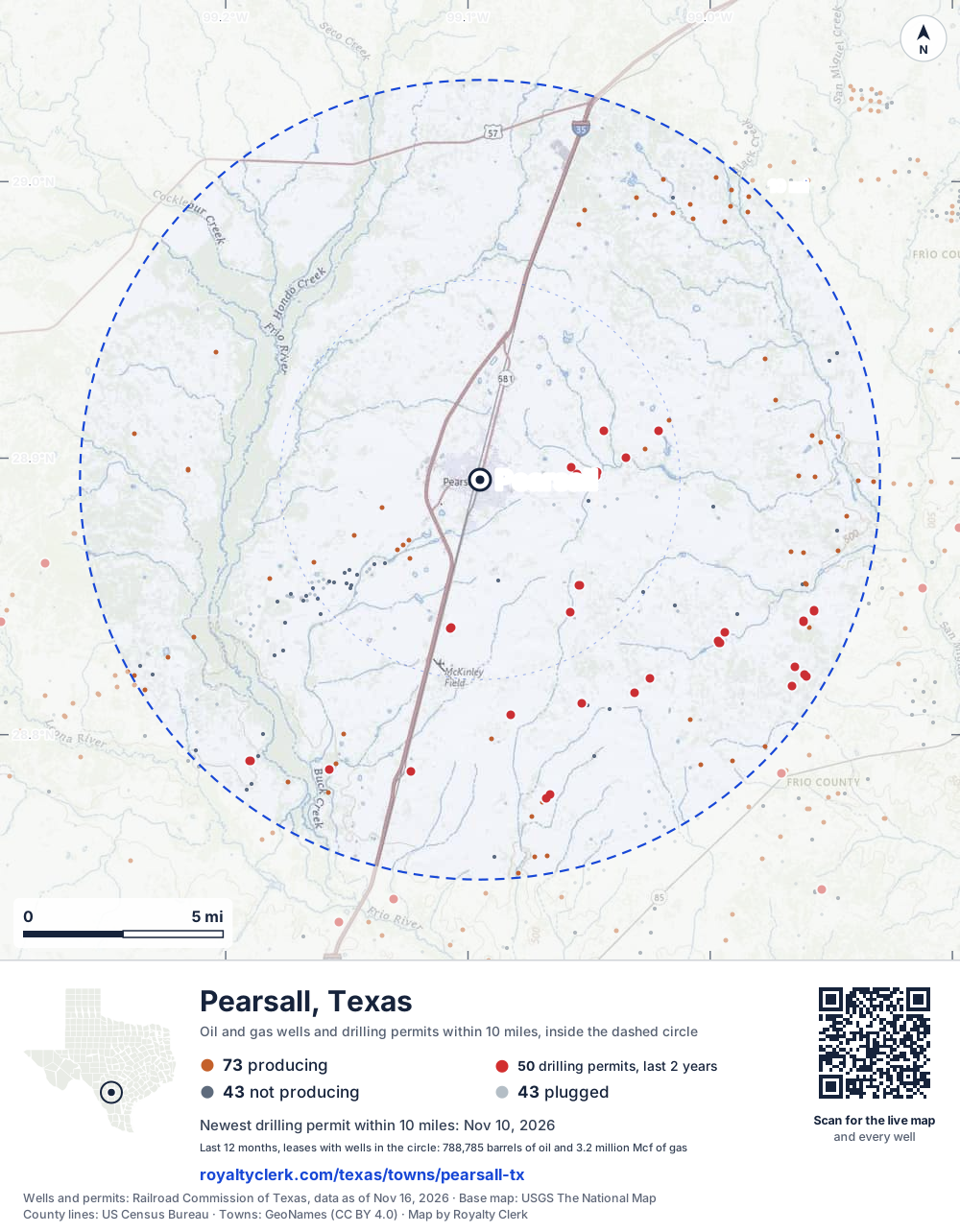
- Drilling locations50Permits issued in the last two years
- Producing wells73On a lease reporting production now
- Not producing43Shut in, inactive or no lease on record
- Plugged43The state's wellbore record says plugged
The dashed circle is 10 miles from the town's point (28.89219, -99.09503); the counts are for wells inside it. Sources: Railroad Commission of Texas well layers and permit files, US Census Bureau county outlines, town points from GeoNames (CC BY 4.0), base map from USGS The National Map.
Use this map on your site
You may show this map on any site, unchanged. Keep the credit line and its link to Royalty Clerk under the map. The picture updates by itself as the state records new wells and permits.
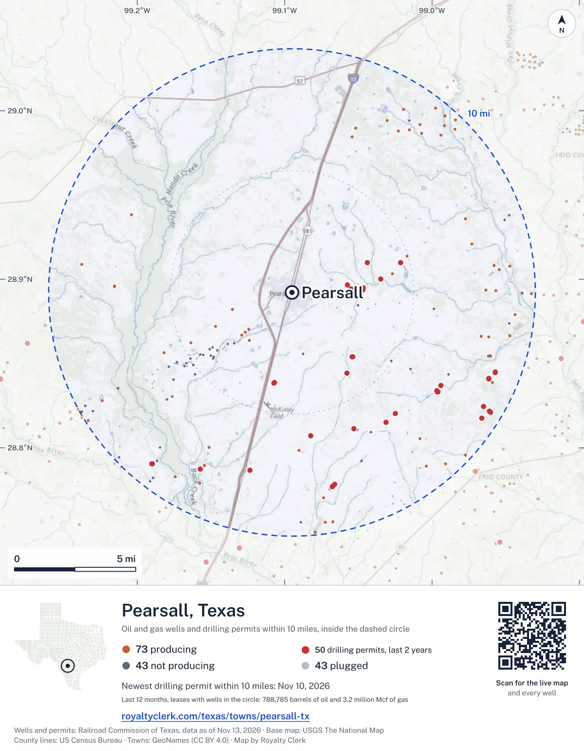
<a href="https://royaltyclerk.com/texas/towns/pearsall-tx"><img src="https://royaltyclerk.com/maps/town-wells/pearsall-tx.svg" alt="Map of Pearsall, Texas: 159 wells and 50 recent drilling locations within 10 miles, inside a dashed circle." width="1000" height="1284" loading="lazy" style="max-width:100%;height:auto;border:0"></a>
<p style="margin:4px 0 0;font-size:14px">Map: <a href="https://royaltyclerk.com/texas/towns/pearsall-tx">Pearsall, Texas oil and gas wells</a> by Royalty Clerk, from Railroad Commission of Texas records</p>
Which way it is heading
Where the new drilling is around Pearsall
What became of the 50 permits
- 4finished, on a lease that reports productionThe well was completed and its lease is reporting oil or gas to the state.
- 2finished, no production reported yetA completion is on file. The first production report follows weeks or months later.
- 25drilling startedThe operator reported a start date. No completion is on file yet.
- 19still only a permitNothing after the permit is on file. Many permits wait a year or more, and some are never drilled.
Wells finished in the last two years: 3 south-east, 2 south of town.
A horizontal well runs sideways underground. 18 wells start outside the 10-mile circle and end inside it. 18 start inside and end outside. So a well can drain land a mile or two from the spot where it shows on a map.
A permit is permission to drill, not a well, and a well nearby says nothing about who owns the minerals under it. Direction is taken from the well's surface location. Source: Railroad Commission of Texas drilling permits and wellbore records.
In numbers
Oil and gas within 10 miles of Pearsall
- wells with a location on the state's map
- 159
- drilling permits in the last 24 months
- 50
- producing leases with a well in the circle
- 46
- operators running them
- 12
- oil and condensate those leases reported in their latest 12 months
- 788,785 bbl
- gas those leases reported in their latest 12 months
- 3,160,413 mcf
A lease counts when at least one of its wells is inside the circle; its whole production is counted, so a lease reaching beyond the circle counts in full.
In dollars
What the oil and gas near Pearsall sold for
- sale value of 12 months, before taxes and costs
- $68 million
- oil and condensate sold
- 789,093 bbl
- gas sold
- 2,908,511 mcf
- the middle lease: half sold more, half less
- $77,914
A 0.01 share (1%) of the middle producing lease near Pearsall comes to about $779 for the 12 months.
Sold volumes at the public monthly prices, before severance tax and any costs. A guide to the size, not what any owner was paid.
Sold volumes from each lease's monthly report to the Railroad Commission, times the month's West Texas Intermediate oil price and Henry Hub gas price (EIA). Real prices at the lease differ. A lease counts in full when one of its wells is near the town. Check a statement against what the lease sold
Drilling locations
The newest drilling permits near Pearsall
| Issued | Lease and well | Where | Operator |
|---|---|---|---|
| 2026-11-10 | SENDERO-UNIT-B S736Hhorizontal · API 42-163-34459 · permit 0919946Formentera Operations LLC | 9.5 mi SE28.82117, -98.96012 on OpenStreetMap (opens in a new tab) | Formentera Operations LLC |
| 2026-11-06 | SENDERO-UNIT-B S734Hhorizontal · API 42-163-34458 · permit 0919945Formentera Operations LLC | 9.5 mi SE28.82111, -98.96018 on OpenStreetMap (opens in a new tab) | Formentera Operations LLC |
| 2026-10-07 | MOJOSA RANCH 706Hhorizontal · API 42-163-34447 · permit 0919097Texas American Resources Company | 3.6 mi SE28.85405, -99.05401 on OpenStreetMap (opens in a new tab) | Texas American Resources Company |
| 2026-10-07 | MOJOSA RANCH 705Hhorizontal · API 42-163-34446 · permit 0919096Texas American Resources Company | 3.6 mi SE28.85399, -99.05407 on OpenStreetMap (opens in a new tab) | Texas American Resources Company |
| 2026-09-23 | ROCKY-UNIT S734Hhorizontal · API 42-163-34445 · permit 0918813Formentera Operations LLC | 3.8 mi S28.83863, -99.10710 on OpenStreetMap (opens in a new tab) | Formentera Operations LLC |
| 2026-09-23 | ROCKY-UNIT S732Hhorizontal · API 42-163-34444 · permit 0918812Formentera Operations LLC | 3.8 mi S28.83857, -99.10716 on OpenStreetMap (opens in a new tab) | Formentera Operations LLC |
| 2026-09-23 | ROCKY-UNIT S730Hhorizontal · API 42-163-34443 · permit 0918811Formentera Operations LLC | 3.8 mi S28.83851, -99.10723 on OpenStreetMap (opens in a new tab) | Formentera Operations LLC |
| 2026-09-11 | NERO-UNIT-B S733Hhorizontal · API 42-163-34442 · permit 0918467Formentera Operations LLC | 9.1 mi SW28.79063, -99.18994 on OpenStreetMap (opens in a new tab) | Formentera Operations LLC |
| 2026-09-10 | NEAL 2vertical · API 42-163-34441 · permit 0918457MB Energy, LLC | 2.4 mi E28.89442, -99.05488 on OpenStreetMap (opens in a new tab) | MB Energy, LLC |
| 2026-08-19 | NERO-UNIT-A S731Hhorizontal · API 42-163-34439 · permit 0917937Formentera Operations LLC | 9.1 mi SW28.79060, -99.18985 on OpenStreetMap (opens in a new tab) | Formentera Operations LLC |
| 2026-08-19 | FLAVIA-UNIT N731Hhorizontal · API 42-163-34440 · permit 0917936Formentera Operations LLC | 9.1 mi SW28.79065, -99.19003 on OpenStreetMap (opens in a new tab) | Formentera Operations LLC |
| 2026-08-12 | NEPTUNE A211VWvertical · API 42-163-34436 · permit 0917763Formentera Operations LLC | 8.1 mi SW28.78740, -99.15729 on OpenStreetMap (opens in a new tab) | Formentera Operations LLC |
| 2026-06-26 | JOSEY WALES C211VWvertical · API 42-163-34430 · permit 0916732Formentera Operations LLC | 8.0 mi S28.77837, -99.06627 on OpenStreetMap (opens in a new tab) | Formentera Operations LLC |
| 2026-06-18 | BUTCH CASSIDY B111VWvertical · API 42-163-34428 · permit 0916552Formentera Operations LLC | 7.2 mi SE28.83691, -98.99407 on OpenStreetMap (opens in a new tab) | Formentera Operations LLC |
| 2026-06-12 | NEAL 2vertical · API 42-163-34420 · permit 0916360Arete Operating Company, LLC | 2.9 mi E28.89494, -99.04672 on OpenStreetMap (opens in a new tab) | Arete Operating Company, LLC |
| 2026-06-09 | OLD LAREDO-UNIT-B S738Hhorizontal · API 42-163-34418 · permit 0916250Formentera Operations LLC | 8.1 mi S28.77695, -99.06778 on OpenStreetMap (opens in a new tab) | Formentera Operations LLC |
| 2026-06-09 | OLD LAREDO-UNIT-A S735Hhorizontal · API 42-163-34419 · permit 0916251Formentera Operations LLC | 8.1 mi S28.77689, -99.06785 on OpenStreetMap (opens in a new tab) | Formentera Operations LLC |
| 2026-04-13 | LUCILLE-STX-UNIT-B S736Hhorizontal · API 42-163-34413 · permit 0914744Formentera Operations LLC | 8.8 mi SE28.84102, -98.96137 on OpenStreetMap (opens in a new tab) | Formentera Operations LLC |
| 2026-04-13 | LUCILLE-STX-UNIT-B S727Hhorizontal · API 42-163-34412 · permit 0914743Formentera Operations LLC | 9.0 mi E28.84485, -98.95698 on OpenStreetMap (opens in a new tab) | Formentera Operations LLC |
| 2026-04-13 | LUCILLE-STX-UNIT-A S724Hhorizontal · API 42-163-34411 · permit 0914741Formentera Operations LLC | 8.8 mi SE28.84096, -98.96144 on OpenStreetMap (opens in a new tab) | Formentera Operations LLC |
| 2026-04-13 | GAMBLER-STX-UNIT N736Hhorizontal · API 42-163-34410 · permit 0914740Formentera Operations LLC | 9.0 mi E28.84474, -98.95712 on OpenStreetMap (opens in a new tab) | Formentera Operations LLC |
| 2026-04-13 | GAMBLER-STX-UNIT N727Hhorizontal · API 42-163-34409 · permit 0914739Formentera Operations LLC | 9.0 mi E28.84480, -98.95705 on OpenStreetMap (opens in a new tab) | Formentera Operations LLC |
| 2026-03-06 | SHELTON UNIT 702Hhorizontal · API 42-163-34405 · permit 0913909Texas American Resources Company | 4.0 mi SE28.84425, -99.05770 on OpenStreetMap (opens in a new tab) | Texas American Resources Company |
| 2026-03-06 | SHELTON UNIT 701Hhorizontal · API 42-163-34404 · permit 0913907Texas American Resources Company | 4.0 mi SE28.84419, -99.05777 on OpenStreetMap (opens in a new tab) | Texas American Resources Company |
| 2026-02-20 | BROOKS-BARRETT-405-STX C111VWvertical · API 42-163-34402 · permit 0913561Formentera Operations LLC | 9.1 mi SE28.82446, -98.96520 on OpenStreetMap (opens in a new tab) | Formentera Operations LLC |
A permit is permission to drill, not a well. Distances are from the town's point to the well's surface location. Source: Railroad Commission of Texas drilling permits.
Find your land
The surveys under the new drilling near Pearsall
- A-309 FRIO CSL, section 27 permits, newest June 18, 2026
- A-308 FRIO CSL, section 36 permits, newest November 24, 2025
- A-405 I&GN RR CO, section 65 permits, newest November 10, 2026
- A-310 FRIO CSL, section 15 permits, newest April 13, 2026
- A-497 MORALES, P F, section 14144 permits, newest September 10, 2026
- A-394 H&GN RR CO, section 4373 permits, newest September 23, 2026
- A-595 STROPE, W3 permits, newest September 11, 2026
- A-754 LIM&C CO, section 1123 permits, newest June 26, 2026
Not in the list? Search every survey in the county by name or abstract number.
Who is on the county roll
What the county mineral roll lists near Pearsall
- mineral accounts on the roll
- 824
- owner names
- 440
- appraised value of those accounts
- $100 million
- the middle account's appraised value
- $2,440
- the middle account in all of Frio County
- $2,360
Totals from the county appraisal district's mineral roll, matched to leases by the state lease number. No owner is named here, and a count under 10 accounts or 5 owner names is left out. How Frio County values minerals, and how to protest · Inherited minerals: where to start
Producing leases
Top producing leases near Pearsall
- 1Roper-STX212,524 bbl · 713,860 mcf a yearFormentera Operations LLC · Frio County · 1 well in the circle
- 2Roper-STX-Unit171,329 bbl · 578,434 mcf a yearFormentera Operations LLC · Frio County · 1 well in the circle
- 3Hooey-STX-Unit139,700 bbl · 449,288 mcf a yearFormentera Operations LLC · Frio County · 1 well in the circle
- 4Sendero-STX-Unit115,558 bbl · 546,448 mcf a yearFormentera Operations LLC · Frio County · 1 well in the circle
- 5Hurrikain Cat I-STX36,102 bbl · 334,726 mcf a yearFormentera Operations LLC · Frio County · 1 well in the circle
- 6Darlene 1-STX30,251 bbl · 244,248 mcf a yearFormentera Operations LLC · Frio County · 1 well in the circle
- 7Stewart16,145 bbl · 0 mcf a yearArete Operating Company, LLC · Frio County · 4 wells in the circle
- 8McWilliams Heirs A3,234 bbl · 65,048 mcf a yearTrailblazer Energy Resources,llc · Frio County · 2 wells in the circle
- 9Hce BB 05N5,338 bbl · 35,249 mcf a yearHuntington Energy, L.L.C. · Frio County · 1 well in the circle
- 10Johnston Ranch11,129 bbl · 0 mcf a yearFlint Oak Energy, LLC · Frio County · 9 wells in the circle
- 11HBR10,385 bbl · 0 mcf a yearBRC Operating Company LLC · Frio County · 8 wells in the circle
- 12George R. Brown3,097 bbl · 35,225 mcf a yearTrailblazer Energy Resources,llc · Frio County · 2 wells in the circle
- 13Hce HM 045,026 bbl · 23,294 mcf a yearHuntington Energy, L.L.C. · Frio County · 1 well in the circle
- 14Little-Dukes Unit993 bbl · 30,449 mcf a yearTrailblazer Energy Resources,llc · Frio County · 1 well in the circle
- 15S Beever Et Al1,317 bbl · 28,452 mcf a yearTrailblazer Energy Resources,llc · Frio County · 2 wells in the circle
- 16Hce BB 05S4,266 bbl · 8,747 mcf a yearHuntington Energy, L.L.C. · Frio County · 1 well in the circle
- 173C Unit4,894 bbl · 0 mcf a yearKsabe Energy Partners, LLC · Frio County · 2 wells in the circle
- 18Little, Virginia L.3,743 bbl · 0 mcf a yearBigfoot Oil LLC · Frio County · 3 wells in the circle
- 19Oppenheimer A746 bbl · 13,582 mcf a yearBlackbrush O & G, LLC · Frio County · 1 well in the circle
- 20Kain2,164 bbl · 0 mcf a yearKain Petroleum, LLC · Frio County · 3 wells in the circle
Whose name is on the check
Who buys the oil and gas near Pearsall
Oil and condensate
- SHELL TRADING (US) COMPANY24 leases
- MEDALLION OPERATING COMPANY, LLC6 leases
- PLAINS MARKETING, L.P.6 leases
- GULFMARK ENERGY, INC.5 leases
- ENTERPRISE CRUDE OIL LLC4 leases
Gas
- TARGA FRIO LASALLE PIPELINE LP25 leases
- ET GATHERING & PROCESSING LLC18 leases
- TARGA MIDSTREAM SERVICES LLC6 leases
- ENTERPRISE PRODUCTS OPERATING LLC3 leases
From each lease's newest Form P-4 filing with the Railroad Commission, which names its gatherers and purchasers. One lease can name several.
If your checks stopped
Leases near Pearsall that went quiet or changed hands
19 leases reported nothing for a year or more
Leases that reported within the last four years and then stopped. The newest to stop first; 10 shown.
- E-F 1893 Unit · Trailblazer Energy Resources,llclast report August 2025
- Kelfer · Trailblazer Energy Resources,llclast report August 2025
- Oppenheimer-Calvert Unit · Blackbrush O & G, LLClast report July 2025
- Riggan · Genesis Well Servicelast report June 2025
- Hce HT 01 · D90 Energy, LLClast report October 2024
- Davies, S.b. Et Al · Maverick Energy Group, Inc.last report June 2024
- Halff & Oppenheimer -C- · Maverick Energy Group, Inc.last report June 2024
- Labatt · Mantle Oil & Gas, LLClast report May 2024
- Russell · Mantle Oil & Gas, LLClast report May 2024
- Thompson, J. C., JR. · Blackbrush O & G, LLClast report January 2024
37 leases got a new operator in two years
Checks often pause after a change while the new company sets up its owner records. The newest first; 10 shown.
- McKinneyAmac Energy, L.L.C. to Flint Oak Energy, LLCAugust 2026
- Hce BB 05Fulcrum Energy Operating, LLC to Huntington Energy, L.L.C.June 2026
- Hce BB 05NFulcrum Energy Operating, LLC to Huntington Energy, L.L.C.June 2026
- Hce BB 05SFulcrum Energy Operating, LLC to Huntington Energy, L.L.C.June 2026
- Hce HM 04Fulcrum Energy Operating, LLC to Huntington Energy, L.L.C.June 2026
- Hce HM 07Fulcrum Energy Operating, LLC to Huntington Energy, L.L.C.June 2026
- Hce HM 08Fulcrum Energy Operating, LLC to Huntington Energy, L.L.C.June 2026
- Hce HM 09Fulcrum Energy Operating, LLC to Huntington Energy, L.L.C.June 2026
- Hce HM 10Fulcrum Energy Operating, LLC to Huntington Energy, L.L.C.June 2026
- Hce HT 03Fulcrum Energy Operating, LLC to Huntington Energy, L.L.C.June 2026
From the monthly production reports operators file with the Railroad Commission. The newest months fill in late, so a lease is listed only after 12 months with no report.
Year by year
Production of the leases near Pearsall, by year
| Year | Oil, bbl | Gas, mcf |
|---|---|---|
| 2026 so far | 434,962 | 1,932,940 |
| 2025 | 658,620 | 2,506,900 |
| 2024 | 123,863 | 391,055 |
| 2023 | 127,698 | 437,692 |
| 2022 | 138,932 | 578,760 |
| 2021 | 152,192 | 477,376 |
| 2020 | 163,191 | 615,918 |
Every lease with a well in the circle, producing now or not, as reported to the Railroad Commission. The newest months fill in as operators report.
The long view: in the state's records from January 1993 on, 87 of these leases reported 5,754,736 bbl of oil and condensate and 14,189,870 mcf of gas. Each lease page carries that lease's history back to January 1993.
Around it
Towns near Pearsall
- Dilley16 mi S550 wells · 47 permits
- Devine21 mi NE1,024 wells · 1 permits
- Charlotte24 mi E630 wells · 12 permits
- Natalia25 mi NE1,499 wells · 12 permits
- Gardendale27 mi S1,522 wells · 51 permits
- Lytle30 mi NE2,355 wells · 12 permits
Pearsall is in ZIP code 78061: its wells and permits
All of Frio County: leases, operators and production · Frio County well map
Press and community kit
Writing about Pearsall? Take what you need
Three facts to quote
- 159 oil and gas wells on the state's map lie within 10 miles of Pearsall: 73 on producing leases, 43 not producing and 43 plugged.
- The Railroad Commission of Texas issued 34 drilling permits within 10 miles of Pearsall in the last 12 months, the newest dated November 10, 2026.
- The 46 producing leases with a well in that circle, run by 12 operators, reported 788,785 barrels of oil and 3,160,413 thousand cubic feet of gas over their latest 12 months.
The map picture
The page's map with its legend and credit, as a JPEG.
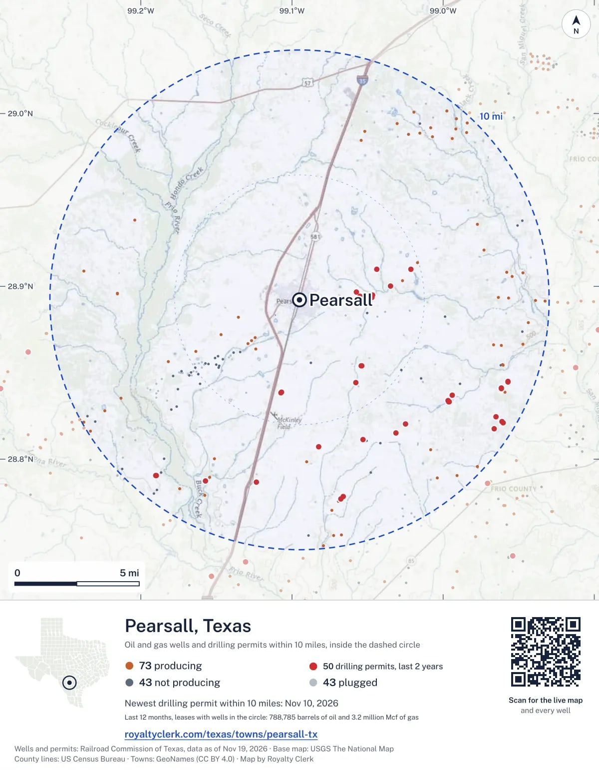

The live map on your page
A frame that loads its picture first and the live map on a tap. No cookies.
How to cite
Railroad Commission of Texas records of the wells and drilling permits within 10 miles of Pearsall, mapped by Royalty Clerk (https://royaltyclerk.com/texas/towns/pearsall-tx), data as of November 15, 2026.
Under a map or a chart: Source: Railroad Commission of Texas · Map: Royalty Clerk, with a link to this page.
The figures say where the state's records put wells and permits, not who owns the land or the minerals. Kits for other Texas towns
Follow it
Watch the 10 miles around Pearsall
Watching a place says nothing about who owns the land or the minerals there. For the whole county, or one survey, use the Frio County well watch.
FAQ
Questions people ask
How many oil and gas wells are near Pearsall?
159 wells with a location on the Railroad Commission's map lie within 10 miles of Pearsall: 73 on leases that are producing, 43 not producing and 43 plugged. The state also issued 50 drilling permits with a well location in that circle in the last 24 months.
What are the coordinates on this page?
Latitude and longitude of the well's surface location in NAD83, the coordinates map apps use. They come from the Railroad Commission's well layers as published, and from its drilling permit files, which are published in the older NAD27 and converted here. Paste them into any map app. A horizontal well's bottom hole can be a mile or two away from its surface location.
Do I own minerals under a well near Pearsall?
A well nearby says nothing about who owns the minerals under it. The county's mineral roll lists who is paid on each producing lease. Search a name to see whether the Frio County roll lists it.
Is drilling near Pearsall picking up or slowing down?
Drilling permits near Pearsall are rising: 34 permits in the last 12 months, 16 in the 12 months before. Most of them are south-east of town: 46 of 50 lie on that side. The nearest is 2.3 miles east of the town's point. A permit is permission to drill, not a well.
How much are the oil and gas near Pearsall worth?
The 46 producing leases with a well within 10 miles sold about $68 million of oil and gas in their newest 12 months on file, at the public monthly prices and before taxes and costs. That is what the leases sold, not what a tract of land or a mineral interest is worth: an owner is paid a share of one lease.
My checks from a lease here stopped. Why?
The usual reasons: the lease stopped producing, a new operator took it over, or the operator put the payments in suspense over a title or address question. Near Pearsall, 19 leases went quiet and 37 changed operator; both lists are on this page.
Own land or minerals near Pearsall?
See whether a county roll lists your name, and get an email when a permit or a new well is filed near you.
Sources
Primary sources, opened on 29 September 2026. Statute text is the current version on statutes.capitol.texas.gov.