
Hockley County, Texas
Hockley County drilling permits: what the state recorded
- 34drilling permits
- 79completions
- 2first-production reports
- in the last twelve months
Wells by coordinates
Oil wells and drilling locations in Hockley County
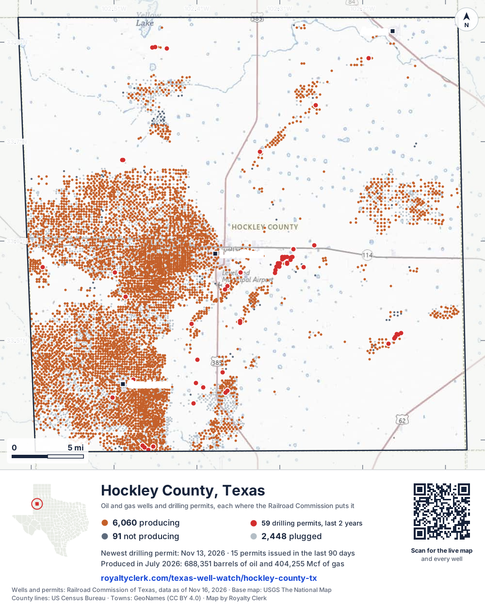
- Drilling locations59Permits issued in the last two years
- Producing wells6,067On a lease reporting production now
- Not producing91Shut in, inactive or no lease on record
- Plugged2,441The state's wellbore record says plugged
Sources: Railroad Commission of Texas well layers and permit files, US Census Bureau county outline, town points from GeoNames (CC BY 4.0), base map from USGS The National Map. A dot is a surface location; a horizontal well runs a mile or more from it.
8,599 wells with a location on the state's map and 59 drilling locations permitted in the last 24 months, each where the Railroad Commission puts it.
A permit is not a well.
Hockley County is one of the 61 counties of the Permian Basin
Wells near each town in Hockley County
Wells within 10 miles of each town, on either side of the county line.
Use this map on your site
You may show this map on any site, unchanged. Keep the credit line and its link to Royalty Clerk under the map. The picture updates by itself as the state records new wells and permits.
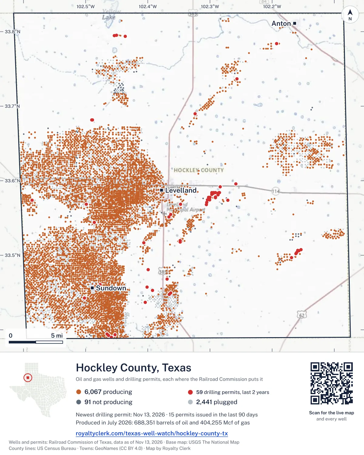
<a href="https://royaltyclerk.com/texas-well-watch/hockley-county-tx"><img src="https://royaltyclerk.com/maps/county-wells/hockley-county-tx.svg" alt="Map of Hockley County, Texas, with 8,599 oil and gas wells and 59 recent drilling locations as dots." width="1000" height="1252" loading="lazy" style="max-width:100%;height:auto;border:0"></a>
<p style="margin:4px 0 0;font-size:14px">Map: <a href="https://royaltyclerk.com/texas-well-watch/hockley-county-tx">Hockley County, Texas oil and gas wells</a> by Royalty Clerk, from Railroad Commission of Texas records</p>
The last twelve months
Month by month in Hockley County
| Month | Permits | Completions | First production |
|---|---|---|---|
| Nov 2026 | 7 | 0 | 0 |
| Oct 2026 | 7 | 0 | 0 |
| Sep 2026 | 1 | 1 | 0 |
| Aug 2026 | 0 | 7 | 0 |
| Jul 2026 | 3 | 9 | 0 |
| Jun 2026 | 3 | 9 | 1 |
| May 2026 | 1 | 7 | 0 |
| Apr 2026 | 3 | 9 | 0 |
| Mar 2026 | 0 | 6 | 0 |
| Feb 2026 | 5 | 6 | 0 |
| Jan 2026 | 1 | 5 | 0 |
| Dec 2025 | 0 | 16 | 1 |
| Nov 2025 | 3 | 4 | 0 |
Counted from November 15, 2025 to November 13, 2026, so the first and last months are partial. Source: Railroad Commission of Texas data sets.
Free, no sign-in
The newest drilling permits in Hockley County
| Issued | Lease and well | Operator | Drilling began | Depth, ft | API number | Coordinates | Permit |
|---|---|---|---|---|---|---|---|
| 2026-11-13 | LAWSON 1Hnew drill · horizontalBeryl Oil and Gas, LPAPI 42-219-37586 · permit 091922633.68139, -102.488975,000 ft | Beryl Oil and Gas, LP | |||||
| 2026-11-12 | STINGER 2new drill · verticalTexland Petroleum, L.P.API 42-219-37594 · permit 092002733.57720, -102.291296,800 ft | Texland Petroleum, L.P. | |||||
| 2026-11-06 | SLIDER 3new drill · verticalTexland Petroleum, L.P.API 42-219-37593 · permit 091992633.58403, -102.284996,800 ft | Texland Petroleum, L.P. | |||||
| 2026-11-05 | JESTER 3new drill · verticalTexland Petroleum, L.P.API 42-219-37590 · permit 091990033.56776, -102.305706,800 ft | Texland Petroleum, L.P. | |||||
| 2026-11-05 | ICEMAN 5new drill · verticalTexland Petroleum, L.P.API 42-219-37592 · permit 091990433.57443, -102.300636,800 ft | Texland Petroleum, L.P. | |||||
| 2026-11-05 | GOOSE 1new drill · verticalTexland Petroleum, L.P.API 42-219-37591 · permit 091989733.58403, -102.296796,800 ft | Texland Petroleum, L.P. | |||||
| 2026-11-04 | FINLEY ESTATE 502recompletion · verticalBurk Royalty Co., Ltd.API 42-219-30915 · permit 091991233.44739, -102.365347,000 ft | Burk Royalty Co., Ltd. | |||||
| 2026-10-30 | COONS, W. A. 80new drill · verticalHilcorp Energy CompanyAPI 42-219-37588 · permit 091964033.38986, -102.458468,300 ft | Hilcorp Energy Company | |||||
| 2026-10-29 | SOUTHEAST WHITEFACE UNIT 1801reclass · verticalRaw Oil & Gas, Inc.API 42-219-33734 · permit 091976833.57404, -102.585944,913 ft | Raw Oil & Gas, Inc. | |||||
| 2026-10-19 | YOUNG-HANKINS 4recompletion · verticalBurk Royalty Co., Ltd.API 42-219-34444 · permit 091936833.57406, -102.271268,000 ft | Burk Royalty Co., Ltd. | |||||
| 2026-10-16 | CARTER, DAVID 1new drill · verticalRogers, S. K. Oil, Inc.API 42-219-37587 · permit 091928233.46806, -102.369057,200 ft | Rogers, S. K. Oil, Inc. | |||||
| 2026-10-14 | FRAZIER, W.G. 110Wrecompletion · verticalOccidental Permian EOR, LLCAPI 42-219-32525 · permit 091856833.39266, -102.463377,972 ft | Occidental Permian EOR, LLC | |||||
| 2026-10-14 | FRAZIER, W.G. 95recompletion · verticalOccidental Permian EOR, LLCAPI 42-219-31844 · permit 091856933.39449, -102.4658612,308 ft | Occidental Permian EOR, LLC | |||||
| 2026-10-05 | PHOENIX 1new drill · verticalTexland Petroleum, L.P.API 42-219-37585 · permit 091900033.59197, -102.283426,900 ft | Texland Petroleum, L.P. | |||||
| 2026-09-21 | LINKER (LOWER CLEARFORK) UNIT 511new drill · verticalBasin Oil & Gas Operating, LLCAPI 42-219-37584 · permit 091869133.55497, -102.363348,000 ft | Basin Oil & Gas Operating, LLC | |||||
| 2026-07-20 | HAMILTON, B. C. 6new drill · verticalRogers, S. K. Oil, Inc.API 42-219-37583 · permit 091722433.51798, -102.347917,000 ft | Rogers, S. K. Oil, Inc. | |||||
| 2026-07-10 | STINGER 1new drill · verticalTexland Petroleum, L.P.API 42-219-37582 · permit 091699633.57838, -102.291286,700 ft | Texland Petroleum, L.P. | |||||
| 2026-07-08 | FELA 1Cnew drill · verticalHet Levelland, LLCAPI 42-219-37581 · permit 091694633.59598, -102.2583011,000 ft | Het Levelland, LLC | |||||
| 2026-06-08 | VALIANT A 1Hnew drill · horizontalBeryl Oil and Gas, LPAPI 42-219-37579 · permit 091612933.79352, -102.43650drilling began 2026-08-21 · 4,500 ft | Beryl Oil and Gas, LP | |||||
| 2026-06-05 | PINK HOUSES SWD 1new drill · verticalBeryl Oil and Gas, LPAPI 42-219-37580 · permit 091613333.68140, -102.4904512,000 ft | Beryl Oil and Gas, LP | |||||
| 2026-06-03 | FINLEY ESTATE 505Wre-entry · verticalBurk Royalty Co., Ltd.API 42-219-31480 · permit 091616333.44957, -102.363207,000 ft | Burk Royalty Co., Ltd. | |||||
| 2026-05-27 | LINKER (LOWER CLEARFORK) UNIT 510new drill · verticalBasin Oil & Gas Operating, LLCAPI 42-219-37578 · permit 091582433.55142, -102.36620drilling began 2026-06-27 · 8,700 ft | Basin Oil & Gas Operating, LLC | |||||
| 2026-04-24 | COONS, W.A. 23recompletion · verticalHilcorp Energy CompanyAPI 42-219-31458 · permit 091431433.39349, -102.452538,100 ft | Hilcorp Energy Company | |||||
| 2026-04-15 | ROOSTER 3new drill · verticalTexland Petroleum, L.P.API 42-219-37577 · permit 091478633.58388, -102.28557drilling began 2026-08-16 · 6,800 ft | Texland Petroleum, L.P. | |||||
| 2026-04-07 | ROPES CANYON REEF UNIT 1014Dnew drill · verticalSaddle Rim Energy (Texas), LLCAPI 42-219-37576 · permit 091447433.49700, -102.16905drilling began 2026-08-17 · 11,600 ft | Saddle Rim Energy (Texas), LLC | |||||
| 2026-02-13 | JESTER 2new drill · verticalTexland Petroleum, L.P.API 42-219-37575 · permit 091345633.57113, -102.305426,800 ft | Texland Petroleum, L.P. | |||||
| 2026-02-13 | HANGMAN 1new drill · verticalTexland Petroleum, L.P.API 42-219-37574 · permit 091345533.57770, -102.30220drilling began 2026-05-15 · 6,800 ft | Texland Petroleum, L.P. | |||||
| 2026-02-12 | ICEMAN 4new drill · verticalTexland Petroleum, L.P.API 42-219-37573 · permit 091341933.57779, -102.302206,600 ft | Texland Petroleum, L.P. | |||||
| 2026-02-12 | VIPER 6new drill · verticalTexland Petroleum, L.P.API 42-219-37572 · permit 091341833.58222, -102.29700drilling began 2026-06-05 · 6,700 ft | Texland Petroleum, L.P. | |||||
| 2026-02-06 | ROPES CANYON REEF UNIT 406new drill · verticalSaddle Rim Energy (Texas), LLCAPI 42-219-37571 · permit 091326033.50372, -102.160579,900 ft | Saddle Rim Energy (Texas), LLC | |||||
| 2026-01-13 | ROPES CANYON REEF UNIT 407new drill · verticalSaddle Rim Energy (Texas), LLCAPI 42-219-37569 · permit 091178633.50613, -102.15709drilling began 2026-07-29 · 9,900 ft | Saddle Rim Energy (Texas), LLC | |||||
| 2025-11-24 | SLIDER 2new drill · verticalTexland Petroleum, L.P.API 42-219-37570 · permit 091188433.58133, -102.28701drilling began 2026-01-09 · 6,700 ft | Texland Petroleum, L.P. | |||||
| 2025-11-20 | ROPES CANYON REEF UNIT 605new drill · verticalSaddle Rim Energy (Texas), LLCAPI 42-219-37567 · permit 091175333.50772, -102.15371drilling began 2026-07-17 · 9,900 ft | Saddle Rim Energy (Texas), LLC | |||||
| 2025-11-17 | ROPES CANYON REEF UNIT 408new drill · verticalSaddle Rim Energy (Texas), LLCAPI 42-219-37568 · permit 091175433.50238, -102.161539,900 ft | Saddle Rim Energy (Texas), LLC | |||||
| 2025-11-04 | SLAUGHTER 34-20 4new drill · verticalV-F Petroleum Inc.API 42-219-37566 · permit 091152533.45724, -102.4011812,000 ft | V-F Petroleum Inc. | |||||
| 2025-10-07 | D.L. SCHWAB 8new drill · verticalRogers, S. K. Oil, Inc.API 42-219-37565 · permit 091090633.45269, -102.392573,000 ft | Rogers, S. K. Oil, Inc. | |||||
| 2025-09-29 | HAMILTON, B. C. 7recompletion · verticalRogers, S. K. Oil, Inc.API 42-219-37487 · permit 091074633.51995, -102.34781drilling began 2020-01-20 · 7,050 ft | Rogers, S. K. Oil, Inc. | |||||
| 2025-09-17 | JACKSON 905new drill · verticalBasin Oil & Gas Operating, LLCAPI 42-219-37564 · permit 091018433.51667, -102.406737,850 ft | Basin Oil & Gas Operating, LLC | |||||
| 2025-09-02 | LINKER (LOWER CLEARFORK) UNIT 102new drill · verticalBasin Oil & Gas Operating, LLCAPI 42-219-37563 · permit 091002233.56851, -102.34751drilling began 2025-11-03 · 8,700 ft | Basin Oil & Gas Operating, LLC | |||||
| 2025-08-28 | ROPES CANYON REEF UNIT 405Arecompletion · verticalSaddle Rim Energy (Texas), LLCAPI 42-219-31107 · permit 091010033.50679, -102.158829,650 ft | Saddle Rim Energy (Texas), LLC | |||||
| 2025-08-26 | CMC 6966Hnew drill · horizontalBeryl Oil and Gas, LPAPI 42-219-37562 · permit 090998933.79457, -102.45367drilling began 2025-10-09 · 4,500 ft | Beryl Oil and Gas, LP | |||||
| 2025-08-12 | SCHOENROCK 'P' 4new drill · verticalTexland Petroleum, L.P.API 42-219-37557 · permit 090895133.68979, -102.32384drilling began 2025-09-12 · 7,400 ft | Texland Petroleum, L.P. | |||||
| 2025-07-25 | SLIDER 1new drill · verticalTexland Petroleum, L.P.API 42-219-37560 · permit 090945233.58348, -102.28652drilling began 2025-10-28 · 6,600 ft | Texland Petroleum, L.P. | |||||
| 2025-07-25 | VIPER 5new drill · verticalTexland Petroleum, L.P.API 42-219-37561 · permit 090945133.58176, -102.29698drilling began 2025-10-01 · 6,800 ft | Texland Petroleum, L.P. | |||||
| 2025-07-24 | JESTER 1new drill · verticalTexland Petroleum, L.P.API 42-219-37559 · permit 090945033.57438, -102.30423drilling began 2025-10-17 · 6,600 ft | Texland Petroleum, L.P. | |||||
| 2025-07-22 | ROOSTER 2new drill · verticalTexland Petroleum, L.P.API 42-219-37558 · permit 090935333.58396, -102.29130drilling began 2025-09-22 · 6,900 ft | Texland Petroleum, L.P. | |||||
| 2025-06-24 | LEVELLAND BRINE 1new drill · verticalTall City Brine LLCAPI 42-219-37556 · permit 090877533.54418, -102.48615drilling began 2025-07-30 · 3,000 ft | Tall City Brine LLC | |||||
| 2025-05-30 | VIPER 4new drill · verticalTexland Petroleum, L.P.API 42-219-37555 · permit 090823033.58167, -102.29698drilling began 2025-10-08 · 6,600 ft | Texland Petroleum, L.P. | |||||
| 2025-04-15 | COBLE 'C' 10reclass · verticalWalkabout Operating, LLCAPI 42-219-32314 · permit 090590033.56832, -102.499135,000 ft | Walkabout Operating, LLC | |||||
| 2025-04-10 | SLAUGHTER 35-30 1new drill · verticalV-F Petroleum Inc.API 42-219-37554 · permit 090730133.43689, -102.4041112,000 ft | V-F Petroleum Inc. |
These are the newest 50 of 78 permits on file for Hockley County. The rest follow, 50 to a page.
A permit is permission to drill, not a well. Source: Railroad Commission of Texas drilling permit files.
Year by year
Drilling permits issued in Hockley County, by year
| Year | Permits issued |
|---|---|
| 2026 so far | 31 |
| 2025 | 24 |
| 2024 | 17 |
| 2023 | 4 |
| 2022 | 1 |
| 2020 | 1 |
Counted from the permit files we hold, which start in 2020; that first year may be partial. Source: Railroad Commission of Texas drilling permit files.
The latest
The most recent records
| Date | What, who and where |
|---|---|
| 2026-11-13 | Permit issued: Beryl Oil and Gas, LPLAWSON · A-189 · permit 0919226 |
| 2026-11-12 | Permit issued: Texland Petroleum, L.P.STINGER · A-140 · permit 0920027 |
| 2026-11-06 | Permit issued: Texland Petroleum, L.P.SLIDER · A-140 · permit 0919926 |
| 2026-11-05 | Permit issued: Texland Petroleum, L.P.JESTER · A-14 · permit 0919900 |
| 2026-11-05 | Permit issued: Texland Petroleum, L.P.ICEMAN · A-140 · permit 0919904 |
| 2026-11-05 | Permit issued: Texland Petroleum, L.P.GOOSE · A-140 · permit 0919897 |
| 2026-11-04 | Permit issued: Burk Royalty Co., Ltd.FINLEY ESTATE · A-5 · permit 0919912 |
| 2026-10-30 | Permit issued: Hilcorp Energy CompanyCOONS, W. A. · A-267 · permit 0919640 |
| 2026-10-29 | Permit issued: Raw Oil & Gas, Inc.SOUTHEAST WHITEFACE UNIT · A-174 · permit 0919768 |
| 2026-10-19 | Permit issued: Burk Royalty Co., Ltd.YOUNG-HANKINS · A-140 · permit 0919368 |
| 2026-10-16 | Permit issued: Rogers, S. K. Oil, Inc.CARTER, DAVID · A-5 · permit 0919282 |
| 2026-10-14 | Permit issued: Occidental Permian EOR, LLCFRAZIER, W.G. · A-273 · permit 0918568 |
| 2026-10-14 | Permit issued: Occidental Permian EOR, LLCFRAZIER, W.G. · A-273 · permit 0918569 |
| 2026-10-05 | Permit issued: Texland Petroleum, L.P.PHOENIX · A-299 · permit 0919000 |
| 2026-09-21 | Permit issued: Basin Oil & Gas Operating, LLCLINKER (LOWER CLEARFORK) UNIT · A-204 · permit 0918691 |
Coming up
First checks coming due in Hockley County
- CENTRAL LEVELLAND UNIT, Occidental Permian EOR, LLCby November 28, 2026
- SLAUGHTER ESTATE UNIT, Hilcorp Energy Companyby November 28, 2026
- CENTRAL MALLET UNIT, Hilcorp Energy Companyby November 28, 2026
- SUNDOWN SLAUGHTER UNIT, Bce-Mach III LLCby November 28, 2026
- JESTER, Texland Petroleum, L.P.by November 28, 2026
- WEST LEVELLAND UNIT, Hilcorp Energy Companyby November 28, 2026
- FRAZIER, W. G., Occidental Permian EOR, LLCby December 29, 2026
- DELOACHE, IRA P., Bce-Mach III LLCby December 29, 2026
- WEST SUNDOWN UNIT, OXY USA EOR, LLCby December 29, 2026
- LEVELLAND UNIT, Occidental Permian EOR, LLCby December 29, 2026
Follow it
Watch Hockley County, or one abstract
What do you want to follow?
Where the land is. Your deed or lease names it.
For example A-1119, or Bush, or T&P 38. Your deed or the tax bill has it.
Other counties
Drilling activity in other counties
Related
Related
- ToolTexas well watchPermit, completion, first production and when the first check is due.
- ToolIs this buyout offer fair?The offer as months of your income, what the acres mean, and the questions to ask.
- ToolIs this lease offer good?Bonus and royalty against the county, and a scan of the lease's clauses.
- Texas dataTexas operator changesWho took over whose leases in the last 24 months.
- ToolLate payment interestDeadlines and the interest a late payment earns.
- Texas dataTexas oil and gas atlas254 counties, every lease, operator and field.
FAQ
Questions people ask
How many wells were permitted in Hockley County in the last year?
The Railroad Commission issued 34 drilling permits in Hockley County in the twelve months to November 13, 2026, and recorded 79 completions and 2 first-production reports. A permit is permission to drill, not a well.
How do I get an alert when a permit is issued near my land in Hockley County?
Choose your abstract on this page, or the whole county, and sign in. You get one email a week, only when something new is recorded after you sign up. The alert says whether an event is on an interest in your Mineral File, on a place you follow, or only nearby.
When is my first royalty check due after a new well?
Natural Resources Code section 91.402(a) says on or before 120 days after the end of the month of first sale of production from the well. The state's first-production month is the closest public marker, so the date on this page is the earliest, not a certainty.
Got a new well on your land?
The first check is due within 120 days after the end of the month of first sale.
Sources
Primary sources, opened on 29 September 2026. Statute text is the current version on statutes.capitol.texas.gov.