
Hockley County, Texas
Oil wells and drilling locations near Sundown
- 6,964wells
- 41drilling locations in two years
- 221producing leases
Within 10 miles
Wells and drilling locations around Sundown
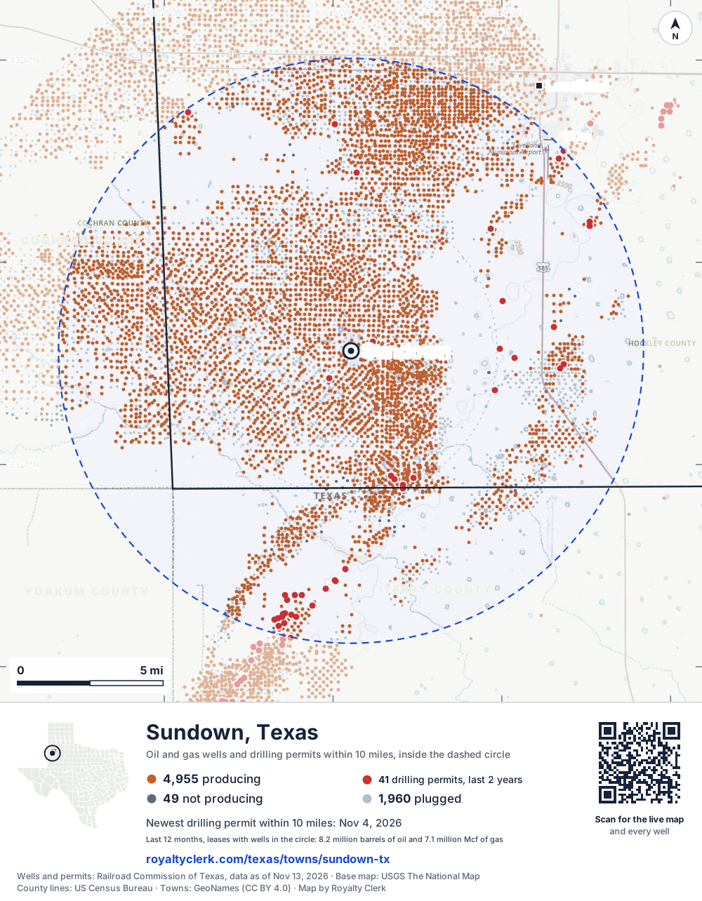
- Drilling locations41Permits issued in the last two years
- Producing wells4,955On a lease reporting production now
- Not producing49Shut in, inactive or no lease on record
- Plugged1,960The state's wellbore record says plugged
The dashed circle is 10 miles from the town's point (33.45621, -102.48936); the counts are for wells inside it. Sources: Railroad Commission of Texas well layers and permit files, US Census Bureau county outlines, town points from GeoNames (CC BY 4.0), base map from USGS The National Map.
Use this map on your site
You may show this map on any site, unchanged. Keep the credit line and its link to Royalty Clerk under the map. The picture updates by itself as the state records new wells and permits.
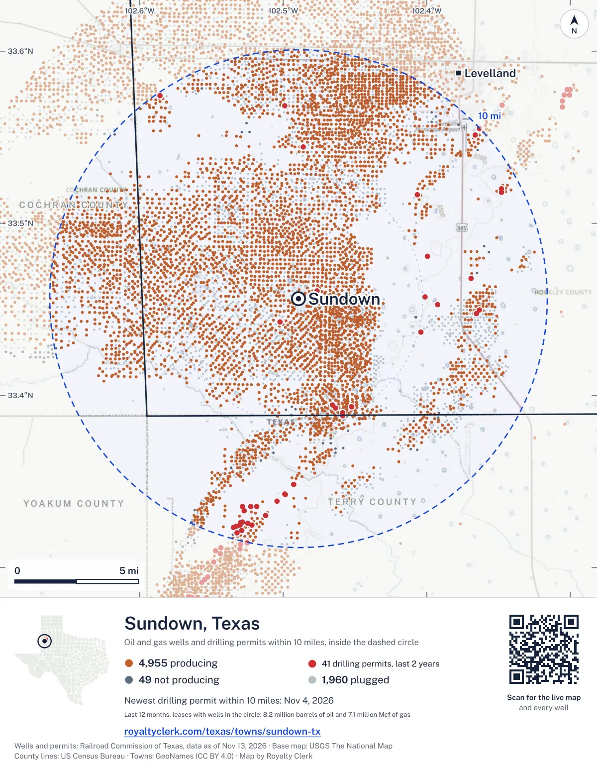
<a href="https://royaltyclerk.com/texas/towns/sundown-tx"><img src="https://royaltyclerk.com/maps/town-wells/sundown-tx.svg" alt="Map of Sundown, Texas: 6,964 wells and 41 recent drilling locations within 10 miles, inside a dashed circle." width="1000" height="1284" loading="lazy" style="max-width:100%;height:auto;border:0"></a>
<p style="margin:4px 0 0;font-size:14px">Map: <a href="https://royaltyclerk.com/texas/towns/sundown-tx">Sundown, Texas oil and gas wells</a> by Royalty Clerk, from Railroad Commission of Texas records</p>
Which way it is heading
Where the new drilling is around Sundown
What became of the 41 permits
- 12finished, on a lease that reports productionThe well was completed and its lease is reporting oil or gas to the state.
- 1finished, no production reported yetA completion is on file. The first production report follows weeks or months later.
- 5drilling startedThe operator reported a start date. No completion is on file yet.
- 23still only a permitNothing after the permit is on file. Many permits wait a year or more, and some are never drilled.
Wells finished in the last two years: 8 north, 2 north-east, 3 east, 1 south-east, 13 south, 4 south-west, 10 west, 6 north-west of town.
A horizontal well runs sideways underground. 1 well starts outside the 10-mile circle and ends inside it. 1 starts inside and ends outside. So a well can drain land a mile or two from the spot where it shows on a map.
A permit is permission to drill, not a well, and a well nearby says nothing about who owns the minerals under it. Direction is taken from the well's surface location. Source: Railroad Commission of Texas drilling permits and wellbore records.
When a new well starts paying
First checks coming due near Sundown
- Igoe-Smith Oper. Area well 25was due October 28, 2026
- Mallet Unit well 713Wwas due October 28, 2026
- West Sundown Unit well 057was due October 28, 2026
- East Mallet Unit well 62Wwas due October 28, 2026
- Slaughter Estate Unit well 450was due October 28, 2026
- Mallet Land & Cattle Company well 11Wwas due October 28, 2026
- Suntura (Lower Clear Fork) Unit well 22Wwas due October 28, 2026
- Dean, Carrie Slaughter "C" well 5was due October 28, 2026
- Igoe-Smith Oper. Area well 17was due October 28, 2026
- Central Levelland Unit well 81Wdue by November 28, 2026
- Slaughter Estate Unit well 85due by November 28, 2026
- Central Mallet Unit well 307due by November 28, 2026
The date is the earliest the law allows a first payment to be late (Texas Natural Resources Code 91.402), worked out from the first month of production on file. It is not a promise of a check: title questions and unsigned division orders can hold one back. Work out a first-check date · What to do before the first check
In numbers
Oil and gas within 10 miles of Sundown
- wells with a location on the state's map
- 6,964
- drilling permits in the last 24 months
- 41
- producing leases with a well in the circle
- 221
- operators running them
- 40
- oil and condensate those leases reported in their latest 12 months
- 8,231,344 bbl
- gas those leases reported in their latest 12 months
- 7,112,706 mcf
A lease counts when at least one of its wells is inside the circle; its whole production is counted, so a lease reaching beyond the circle counts in full.
In dollars
What the oil and gas near Sundown sold for
- sale value of 12 months, before taxes and costs
- $648 million
- oil and condensate sold
- 8,223,291 bbl
- gas sold
- 7,088,271 mcf
- the middle lease: half sold more, half less
- $207,505
A 0.01 share (1%) of the middle producing lease near Sundown comes to about $2,075 for the 12 months.
Sold volumes at the public monthly prices, before severance tax and any costs. A guide to the size, not what any owner was paid.
Sold volumes from each lease's monthly report to the Railroad Commission, times the month's West Texas Intermediate oil price and Henry Hub gas price (EIA). Real prices at the lease differ. A lease counts in full when one of its wells is near the town. Check a statement against what the lease sold
Drilling locations
The newest drilling permits near Sundown
| Issued | Lease and well | Where | Operator |
|---|---|---|---|
| 2026-11-04 | FINLEY ESTATE 502vertical · API 42-219-30915 · permit 0919912Burk Royalty Co., Ltd. | 7.2 mi E33.44739, -102.36534 on OpenStreetMap (opens in a new tab) | Burk Royalty Co., Ltd. |
| 2026-10-30 | COONS, W. A. 80vertical · API 42-219-37588 · permit 0919640Hilcorp Energy Company | 4.9 mi S33.38986, -102.45846 on OpenStreetMap (opens in a new tab) | Hilcorp Energy Company |
| 2026-10-29 | SOUTHEAST WHITEFACE UNIT 1801vertical · API 42-219-33734 · permit 0919768Raw Oil & Gas, Inc. | 9.9 mi NW33.57404, -102.58594 on OpenStreetMap (opens in a new tab) | Raw Oil & Gas, Inc. |
| 2026-10-16 | CARTER, DAVID 1vertical · API 42-219-37587 · permit 0919282Rogers, S. K. Oil, Inc. | 7.0 mi E33.46806, -102.36905 on OpenStreetMap (opens in a new tab) | Rogers, S. K. Oil, Inc. |
| 2026-10-14 | FRAZIER, W.G. 110Wvertical · API 42-219-32525 · permit 0918568Occidental Permian EOR, LLC | 4.6 mi S33.39266, -102.46337 on OpenStreetMap (opens in a new tab) | Occidental Permian EOR, LLC |
| 2026-10-14 | FRAZIER, W.G. 95vertical · API 42-219-31844 · permit 0918569Occidental Permian EOR, LLC | 4.5 mi S33.39449, -102.46586 on OpenStreetMap (opens in a new tab) | Occidental Permian EOR, LLC |
| 2026-09-21 | LINKER (LOWER CLEARFORK) UNIT 511vertical · API 42-219-37584 · permit 0918691Basin Oil & Gas Operating, LLC | 10.0 mi NE33.55497, -102.36334 on OpenStreetMap (opens in a new tab) | Basin Oil & Gas Operating, LLC |
| 2026-09-16 | SUNTURA (LOWER CLEAR FORK) UNIT 7RWvertical · API 42-445-32514 · permit 0918679Basin Oil & Gas Operating, LLC | 9.6 mi S33.32150, -102.52876 on OpenStreetMap (opens in a new tab) | Basin Oil & Gas Operating, LLC |
| 2026-09-15 | SUNTURA (LOWER CLEAR FORK) UNIT 12Wvertical · API 42-445-32513 · permit 0918589Basin Oil & Gas Operating, LLC | 9.4 mi S33.32476, -102.53019 on OpenStreetMap (opens in a new tab) | Basin Oil & Gas Operating, LLC |
| 2026-08-20 | SUNTURA (LOWER CLEAR FORK) UNIT 605vertical · API 42-445-32512 · permit 0917776Basin Oil & Gas Operating, LLC | 10.0 mi S33.31444, -102.52516 on OpenStreetMap (opens in a new tab) | Basin Oil & Gas Operating, LLC |
| 2026-07-20 | HAMILTON, B. C. 6vertical · API 42-219-37583 · permit 0917224Rogers, S. K. Oil, Inc. | 9.2 mi NE33.51798, -102.34791 on OpenStreetMap (opens in a new tab) | Rogers, S. K. Oil, Inc. |
| 2026-07-16 | SUNTURA (LOWER CLEAR FORK) UNIT 520vertical · API 42-445-32510 · permit 0916980Basin Oil & Gas Operating, LLC | 9.2 mi S33.32639, -102.52833 on OpenStreetMap (opens in a new tab) | Basin Oil & Gas Operating, LLC |
| 2026-06-18 | SUNTURA (LOWER CLEAR FORK) UNIT 521vertical · API 42-445-32509 · permit 0916525Basin Oil & Gas Operating, LLC | 9.7 mi S33.32010, -102.53234 on OpenStreetMap (opens in a new tab) | Basin Oil & Gas Operating, LLC |
| 2026-06-03 | FINLEY ESTATE 505Wvertical · API 42-219-31480 · permit 0916163Burk Royalty Co., Ltd. | 7.3 mi E33.44957, -102.36320 on OpenStreetMap (opens in a new tab) | Burk Royalty Co., Ltd. |
| 2026-05-27 | LINKER (LOWER CLEARFORK) UNIT 510vertical · API 42-219-37578 · permit 0915824Basin Oil & Gas Operating, LLC | 9.7 mi NE33.55142, -102.36620 on OpenStreetMap (opens in a new tab) | Basin Oil & Gas Operating, LLC |
| 2026-04-24 | COONS, W.A. 23vertical · API 42-219-31458 · permit 0914314Hilcorp Energy Company | 4.8 mi SE33.39349, -102.45253 on OpenStreetMap (opens in a new tab) | Hilcorp Energy Company |
| 2026-04-22 | COONS, W.A. 25vertical · API 42-445-30577 · permit 0914324Hilcorp Energy Company | 5.0 mi S33.38810, -102.45863 on OpenStreetMap (opens in a new tab) | Hilcorp Energy Company |
| 2026-04-07 | STATE REDLANDS 6vertical · API 42-445-32506 · permit 0914553Cory, Kenneth W. Ltd. | 8.6 mi S33.33550, -102.52832 on OpenStreetMap (opens in a new tab) | Cory, Kenneth W. Ltd. |
| 2026-04-07 | STATE REDLANDS 5vertical · API 42-445-32505 · permit 0914552Cory, Kenneth W. Ltd. | 8.5 mi S33.33539, -102.51845 on OpenStreetMap (opens in a new tab) | Cory, Kenneth W. Ltd. |
| 2026-03-25 | SUNTURA (LOWER CLEAR FORK) UNIT 518vertical · API 42-445-32504 · permit 0914058Basin Oil & Gas Operating, LLC | 9.2 mi S33.32568, -102.52470 on OpenStreetMap (opens in a new tab) | Basin Oil & Gas Operating, LLC |
| 2026-02-20 | SUNTURA (LOWER CLEAR FORK) UNIT 517vertical · API 42-445-32501 · permit 0913508Basin Oil & Gas Operating, LLC | 9.3 mi S33.32613, -102.52981 on OpenStreetMap (opens in a new tab) | Basin Oil & Gas Operating, LLC |
| 2025-12-08 | SUNTURA (LOWER CLEAR FORK) UNIT 516vertical · API 42-445-32500 · permit 0912078Basin Oil & Gas Operating, LLC | 9.5 mi S33.32392, -102.53250 on OpenStreetMap (opens in a new tab) | Basin Oil & Gas Operating, LLC |
| 2025-11-04 | SLAUGHTER 34-20 4vertical · API 42-219-37566 · permit 0911525V-F Petroleum Inc. | 5.1 mi E33.45724, -102.40118 on OpenStreetMap (opens in a new tab) | V-F Petroleum Inc. |
| 2025-10-30 | BUSTER 2003vertical · API 42-445-32495 · permit 0911468Basin Oil & Gas Operating, LLC | 7.8 mi S33.34269, -102.49880 on OpenStreetMap (opens in a new tab) | Basin Oil & Gas Operating, LLC |
| 2025-10-30 | BUSTER 2002vertical · API 42-445-32494 · permit 0911467Basin Oil & Gas Operating, LLC | 7.9 mi S33.34243, -102.49850 on OpenStreetMap (opens in a new tab) | Basin Oil & Gas Operating, LLC |
A permit is permission to drill, not a well. Distances are from the town's point to the well's surface location. Source: Railroad Commission of Texas drilling permits.
Find your land
The surveys under the new drilling near Sundown
- A-70 C&M RR CO, block D14, section 139 permits, newest September 16, 2026
- A-5 BAYLOR CSL, section 334 permits, newest November 4, 2026
- A-1260 PRESTON, T B, block D14, section 123 permits, newest April 7, 2026
- A-720 ROSS, P J, block D11, section 203 permits, newest October 30, 2025
- A-267 COWAN, S, block X, section 112 permits, newest October 30, 2026
- A-273 FRAZIER, L, block X, section 102 permits, newest October 14, 2026
- A-204 RUSK CSL, section 292 permits, newest September 21, 2026
- A-139 WHARTON CSL2 permits, newest July 20, 2026
Not in the list? Search every survey in the county by name or abstract number.
Producing leases
Top producing leases near Sundown
- 1Levelland Unit1,008,547 bbl · 819,119 mcf a yearOccidental Permian EOR, LLC · Hockley County · 564 wells in the circle
- 2West Sundown Unit861,860 bbl · 515,604 mcf a yearOXY USA EOR, LLC · Hockley County · 232 wells in the circle
- 3Sundown Slaughter Unit691,147 bbl · 1,147,119 mcf a yearBce-Mach III LLC · Hockley County · 559 wells in the circle
- 4Slaughter Consolidated334,058 bbl · 1,534,605 mcf a yearHilcorp Energy Company · Hockley County · 104 wells in the circle
- 5Southeast Levelland Unit487,713 bbl · 426,419 mcf a yearOccidental Permian EOR, LLC · Hockley County · 382 wells in the circle
- 6Central Mallet Unit448,998 bbl · 515,734 mcf a yearHilcorp Energy Company · Hockley County · 360 wells in the circle
- 7West RKM Unit379,257 bbl · 246,843 mcf a yearOccidental Permian EOR, LLC · Hockley County · 303 wells in the circle
- 8Slaughter Estate Unit346,663 bbl · 354,181 mcf a yearHilcorp Energy Company · Hockley County · 405 wells in the circle
- 9Mallet Unit317,724 bbl · 208,276 mcf a yearHilcorp Energy Company · Hockley County · 288 wells in the circle
- 10Linker (Lower Clearfork) Unit259,273 bbl · 22,249 mcf a yearBasin Oil & Gas Operating, LLC · Hockley County · 19 wells in the circle
- 11North Central Levelland Unit248,618 bbl · 51,035 mcf a yearHilcorp Energy Company · Hockley County · 15 wells in the circle
- 12Northwest Mallet Unit217,971 bbl · 107,847 mcf a yearHilcorp Energy Company · Hockley County · 179 wells in the circle
- 13Suntura (Lower Clear Fork) Unit223,383 bbl · 20,593 mcf a yearBasin Oil & Gas Operating, LLC · Terry County · 37 wells in the circle
- 14West Levelland Unit178,936 bbl · 45,176 mcf a yearHilcorp Energy Company · Cochran County · 1 well in the circle
- 15East Mallet Unit118,003 bbl · 269,069 mcf a yearHilcorp Energy Company · Hockley County · 170 wells in the circle
- 16Igoe-Smith Oper. Area126,157 bbl · 76,751 mcf a yearOccidental Permian EOR, LLC · Cochran County · 111 wells in the circle
- 17Central Levelland Unit129,580 bbl · 44,352 mcf a yearOccidental Permian EOR, LLC · Hockley County · 300 wells in the circle
- 18Boyd118,050 bbl · 99,584 mcf a yearHilcorp Energy Company · Cochran County · 75 wells in the circle
- 19Sundown Unit110,311 bbl · 62,419 mcf a yearHilcorp Energy Company · Hockley County · 103 wells in the circle
- 20Woodley, F. L.85,734 bbl · 69,978 mcf a yearHilcorp Energy Company · Cochran County · 101 wells in the circle
Whose name is on the check
Who buys the oil and gas near Sundown
Oil and condensate
- SENTINEL TRANSPORTATION, LLC129 leases
- ENERGY TRANSFER COMPANY39 leases
- LPC CRUDE III, LLC23 leases
- PLAINS MARKETING, L.P.16 leases
- PLAINS PIPELINE L.P.14 leases
Gas
- OCCIDENTAL PERMIAN LTD.60 leases
- TARGA MIDSTREAM SERVICES LLC20 leases
- BULLIN, R. E. OPERATING INC.8 leases
- LUBBOCK GAS GATHERING LTD., LLP8 leases
- DCP OPERATING COMPANY, LP3 leases
From each lease's newest Form P-4 filing with the Railroad Commission, which names its gatherers and purchasers. One lease can name several.
If your checks stopped
Leases near Sundown that went quiet or changed hands
13 leases reported nothing for a year or more
Leases that reported within the last four years and then stopped. The newest to stop first; 10 shown.
- Red Raider · Stanolind Permian LLClast report July 2025
- Northwest Terry (Abo) Unit · T2 Operating Corporationlast report May 2025
- Wright, D. S. · Ip Well Service LLClast report April 2025
- Pool-Hannes "37" · Texland Petroleum, L.P.last report April 2025
- Hunt-Slaughter · Burk Royalty Co., Ltd.last report January 2024
- Reddoch "17" · Extech Operating, LLClast report December 2023
- Amoco-Schroer · Texland Petroleum, L.P.last report April 2023
- Jacobson Trail · Boaz Energy II Operating, LLClast report February 2023
- Day, Cacy "A" · Great Western Drilling Companylast report December 2022
- Brown, Nelson · Legacy Reserves Operating LPlast report November 2022
129 leases got a new operator in two years
Checks often pause after a change while the new company sets up its owner records. The newest first; 10 shown.
- BoydOXY USA WTP LP to Hilcorp Energy CompanyJuly 2026
- Duggan Slaughter UnitCross Timbers Energy, LLC to Ctoc Energy, LLCJune 2026
- Hudgens, L. F.Cross Timbers Energy, LLC to Ctoc Energy, LLCJune 2026
- LevellandCross Timbers Energy, LLC to Ctoc Energy, LLCJune 2026
- Lucas, G. B.Cross Timbers Energy, LLC to Ctoc Energy, LLCJune 2026
- Mallet Land & Cattle Co.Cross Timbers Energy, LLC to Ctoc Energy, LLCJune 2026
- Mallet Land & Cattle Co.Cross Timbers Energy, LLC to Ctoc Energy, LLCJune 2026
- Mallet Land & Cattle CompanyCross Timbers Energy, LLC to Ctoc Energy, LLCJune 2026
- Mallet Land & Cattle CompanyCross Timbers Energy, LLC to Ctoc Energy, LLCJune 2026
- Mallet L&C Co.Cross Timbers Energy, LLC to Ctoc Energy, LLCJune 2026
From the monthly production reports operators file with the Railroad Commission. The newest months fill in late, so a lease is listed only after 12 months with no report.
Year by year
Production of the leases near Sundown, by year
| Year | Oil, bbl | Gas, mcf |
|---|---|---|
| 2026 so far | 5,396,768 | 5,013,991 |
| 2025 | 8,631,844 | 5,701,028 |
| 2024 | 9,321,339 | 6,156,262 |
| 2023 | 9,855,253 | 6,622,144 |
| 2022 | 10,522,592 | 5,862,943 |
| 2021 | 10,823,671 | 6,020,047 |
| 2020 | 11,288,009 | 6,354,673 |
Every lease with a well in the circle, producing now or not, as reported to the Railroad Commission. The newest months fill in as operators report.
The long view: in the state's records from January 1993 on, 258 of these leases reported 519,952,434 bbl of oil and condensate and 653,505,592 mcf of gas. Each lease page carries that lease's history back to January 1993.
Around it
Towns near Sundown
- Levelland11 mi NE4,298 wells · 40 permits
- Brownfield23 mi SE13 wells · 2 permits
- Morton24 mi NW565 wells · 1 permits
- Plains27 mi SW2,504 wells · 97 permits
- Wolfforth28 mi E151 wells · 17 permits
Sundown is in ZIP code 79372: its wells and permits
All of Hockley County: leases, operators and production · Hockley County well map
Press and community kit
Writing about Sundown? Take what you need
Three facts to quote
- 6,964 oil and gas wells on the state's map lie within 10 miles of Sundown: 4,955 on producing leases, 49 not producing and 1,960 plugged.
- The Railroad Commission of Texas issued 22 drilling permits within 10 miles of Sundown in the last 12 months, the newest dated November 4, 2026.
- The 221 producing leases with a well in that circle, run by 40 operators, reported 8,231,344 barrels of oil and 7,112,706 thousand cubic feet of gas over their latest 12 months.
The map picture
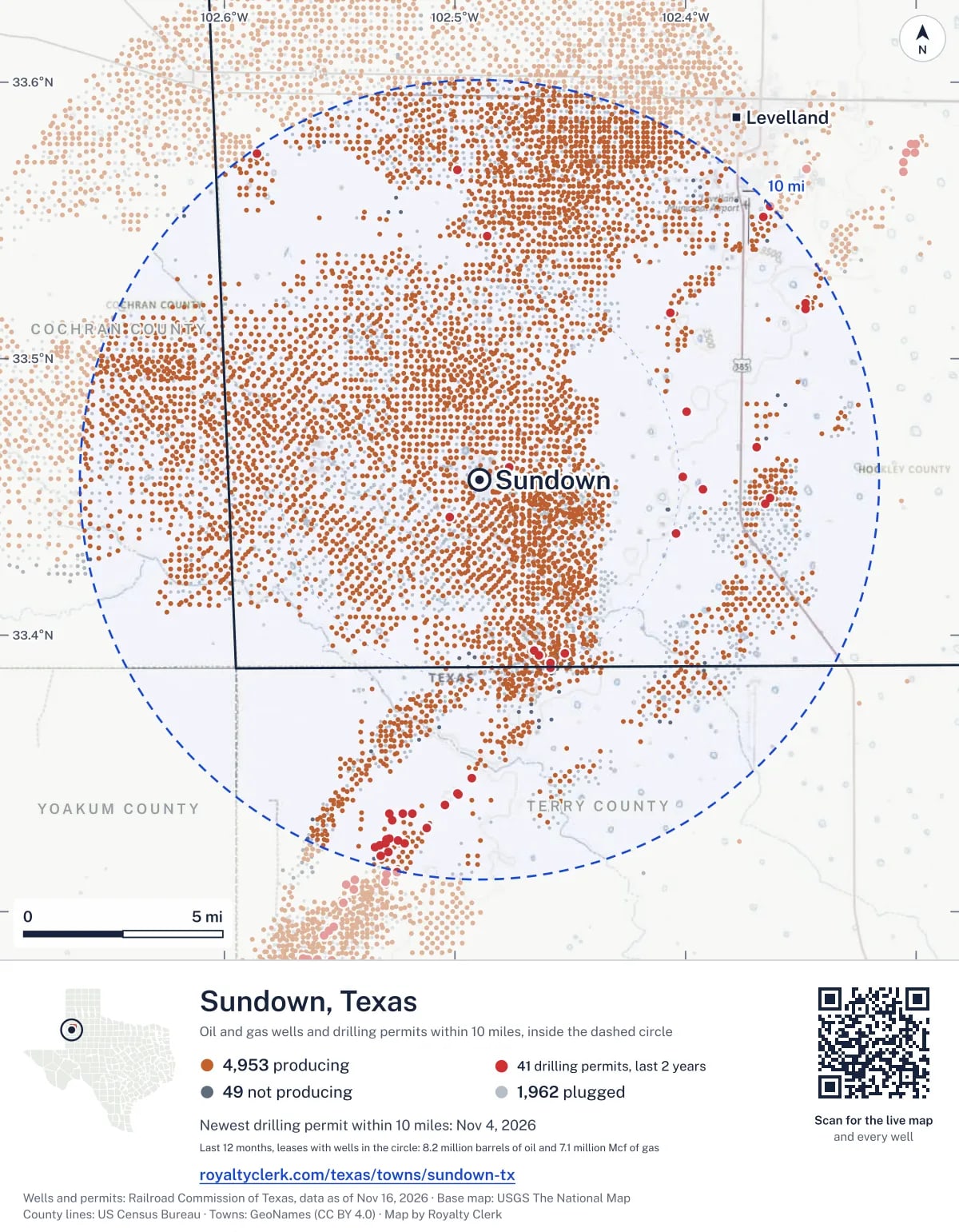
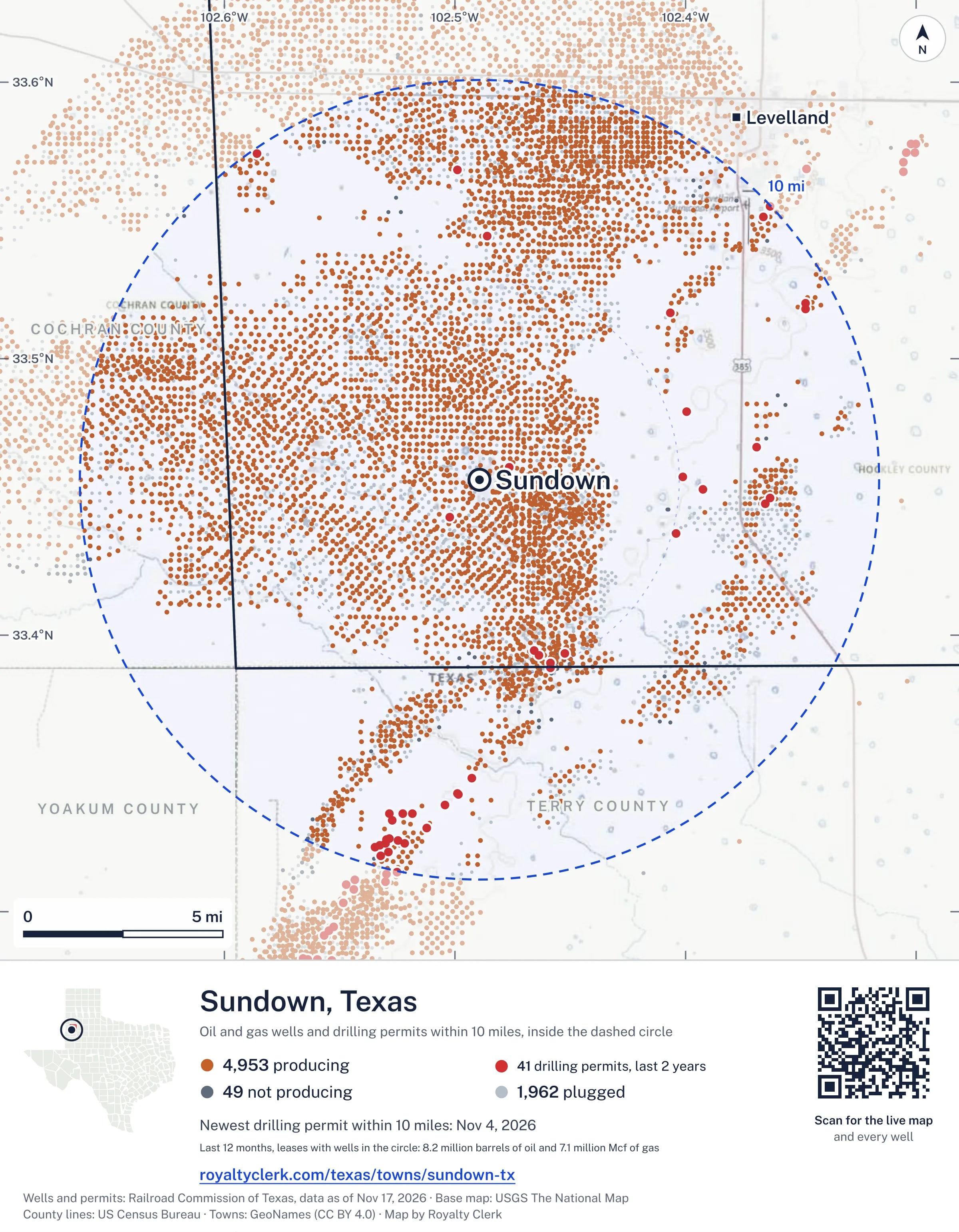
The page's map with its legend and credit, as a JPEG.
The live map on your page
A frame that loads its picture first and the live map on a tap. No cookies.
How to cite
Railroad Commission of Texas records of the wells and drilling permits within 10 miles of Sundown, mapped by Royalty Clerk (https://royaltyclerk.com/texas/towns/sundown-tx), data as of November 15, 2026.
Under a map or a chart: Source: Railroad Commission of Texas · Map: Royalty Clerk, with a link to this page.
The figures say where the state's records put wells and permits, not who owns the land or the minerals. Kits for other Texas towns
Follow it
Watch the 10 miles around Sundown
Watching a place says nothing about who owns the land or the minerals there. For the whole county, or one survey, use the Hockley County well watch.
FAQ
Questions people ask
How many oil and gas wells are near Sundown?
6,964 wells with a location on the Railroad Commission's map lie within 10 miles of Sundown: 4,955 on leases that are producing, 49 not producing and 1,960 plugged. The state also issued 41 drilling permits with a well location in that circle in the last 24 months.
What are the coordinates on this page?
Latitude and longitude of the well's surface location in NAD83, the coordinates map apps use. They come from the Railroad Commission's well layers as published, and from its drilling permit files, which are published in the older NAD27 and converted here. Paste them into any map app. A horizontal well's bottom hole can be a mile or two away from its surface location.
Do I own minerals under a well near Sundown?
A well nearby says nothing about who owns the minerals under it. The county's mineral roll lists who is paid on each producing lease. Search a name to see whether the Hockley County roll lists it.
Is drilling near Sundown picking up or slowing down?
Drilling permits near Sundown are holding steady: 22 permits in the last 12 months, 19 in the 12 months before. They are spread around town, with no side clearly ahead. The nearest is under a mile east of the town's point. A permit is permission to drill, not a well.
When does a new well near Sundown start paying royalties?
Texas law gives the payor 120 days after the end of the month of first sale to send the first payment (Natural Resources Code 91.402). The next date on file for a lease near Sundown is November 28, 2026. The date is the earliest a first payment becomes late, not a promise: a title question or an unsigned division order can hold a check back.
How much are the oil and gas near Sundown worth?
The 221 producing leases with a well within 10 miles sold about $648 million of oil and gas in their newest 12 months on file, at the public monthly prices and before taxes and costs. That is what the leases sold, not what a tract of land or a mineral interest is worth: an owner is paid a share of one lease.
My checks from a lease here stopped. Why?
The usual reasons: the lease stopped producing, a new operator took it over, or the operator put the payments in suspense over a title or address question. Near Sundown, 13 leases went quiet and 129 changed operator; both lists are on this page.
Own land or minerals near Sundown?
The next first check near Sundown falls due by November 28, 2026. See whether a county roll lists your name, and get an email when a permit or a new well is filed near you.
Sources
Primary sources, opened on 29 September 2026. Statute text is the current version on statutes.capitol.texas.gov.