
Howard County, Texas
Howard County drilling permits: what the state recorded
- 163drilling permits
- 106completions
- 23first-production reports
- in the last twelve months
Wells by coordinates
Oil wells and drilling locations in Howard County
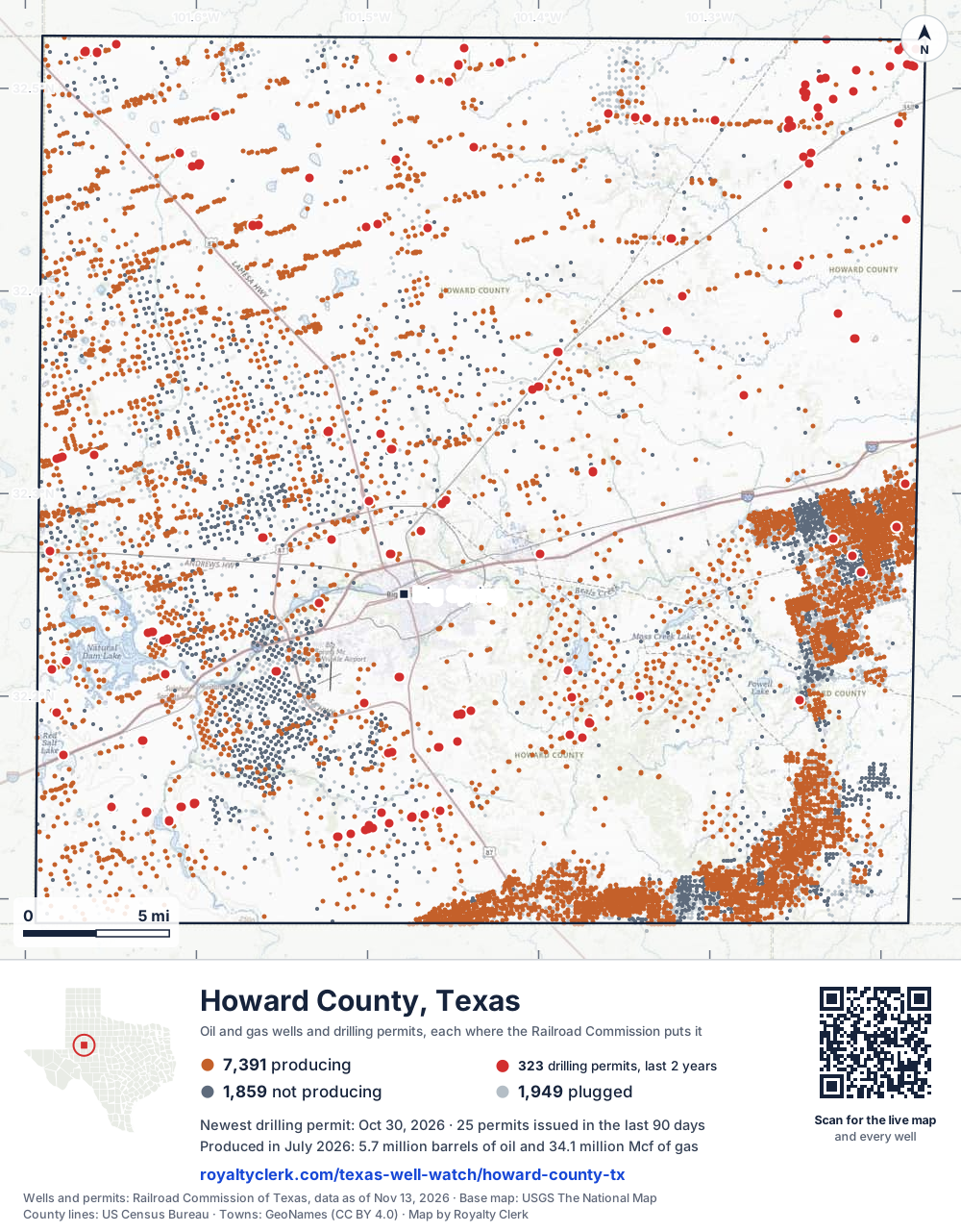
- Drilling locations323Permits issued in the last two years
- Producing wells7,392On a lease reporting production now
- Not producing1,861Shut in, inactive or no lease on record
- Plugged1,946The state's wellbore record says plugged
Sources: Railroad Commission of Texas well layers and permit files, US Census Bureau county outline, town points from GeoNames (CC BY 4.0), base map from USGS The National Map. A dot is a surface location; a horizontal well runs a mile or more from it.
11,199 wells with a location on the state's map and 323 drilling locations permitted in the last 24 months, each where the Railroad Commission puts it.
A permit is not a well.
Howard County is one of the 61 counties of the Permian Basin
Wells near each town in Howard County
Wells within 10 miles of each town, on either side of the county line.
Use this map on your site
You may show this map on any site, unchanged. Keep the credit line and its link to Royalty Clerk under the map. The picture updates by itself as the state records new wells and permits.
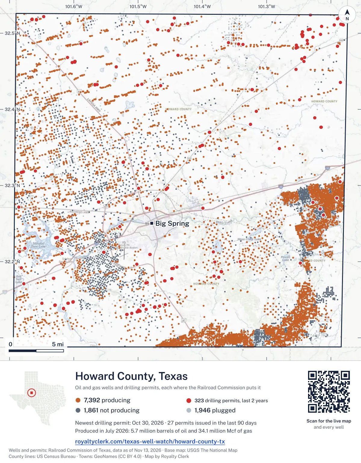
<a href="https://royaltyclerk.com/texas-well-watch/howard-county-tx"><img src="https://royaltyclerk.com/maps/county-wells/howard-county-tx.svg" alt="Map of Howard County, Texas, with 11,199 oil and gas wells and 323 recent drilling locations as dots." width="1000" height="1281" loading="lazy" style="max-width:100%;height:auto;border:0"></a>
<p style="margin:4px 0 0;font-size:14px">Map: <a href="https://royaltyclerk.com/texas-well-watch/howard-county-tx">Howard County, Texas oil and gas wells</a> by Royalty Clerk, from Railroad Commission of Texas records</p>
The last twelve months
Month by month in Howard County
| Month | Permits | Completions | First production |
|---|---|---|---|
| Oct 2026 | 16 | 0 | 0 |
| Sep 2026 | 9 | 2 | 0 |
| Aug 2026 | 11 | 0 | 2 |
| Jul 2026 | 4 | 0 | 2 |
| Jun 2026 | 8 | 8 | 0 |
| May 2026 | 16 | 11 | 1 |
| Apr 2026 | 15 | 17 | 6 |
| Mar 2026 | 31 | 16 | 3 |
| Feb 2026 | 11 | 14 | 2 |
| Jan 2026 | 20 | 15 | 2 |
| Dec 2025 | 13 | 15 | 5 |
| Nov 2025 | 9 | 8 | 0 |
Counted from November 15, 2025 to October 30, 2026, so the first and last months are partial. Source: Railroad Commission of Texas data sets.
Free, no sign-in
The newest drilling permits in Howard County
| Issued | Lease and well | Operator | Drilling began | Depth, ft | API number | Coordinates | Permit |
|---|---|---|---|---|---|---|---|
| 2026-10-30 | WILDCAT 1new drill · verticalEnterprise Products OperatingllcAPI 42-227-42941 · permit 091941532.17080, -101.67747380 ft | Enterprise Products Operatingllc | |||||
| 2026-10-26 | WILLIS WINTERS 1re-entry · verticalHighpeak Energy Holdings, LLCAPI 42-227-02549 · permit 091967632.49451, -101.227857,536 ft | Highpeak Energy Holdings, LLC | |||||
| 2026-10-20 | BLUESTEM G 11DNnew drill · horizontalOxyrock Operating, LLCAPI 42-227-42940 · permit 091936132.23175, -101.6256812,000 ft | Oxyrock Operating, LLC | |||||
| 2026-10-20 | BLUESTEM F 10HAnew drill · horizontalOxyrock Operating, LLCAPI 42-227-42939 · permit 091935932.23172, -101.6257712,000 ft | Oxyrock Operating, LLC | |||||
| 2026-10-20 | BLUESTEM F 9LLnew drill · horizontalOxyrock Operating, LLCAPI 42-227-42938 · permit 091935732.23170, -101.6258612,000 ft | Oxyrock Operating, LLC | |||||
| 2026-10-20 | BLUESTEM F 8DNnew drill · horizontalOxyrock Operating, LLCAPI 42-227-42937 · permit 091935632.23168, -101.6259612,000 ft | Oxyrock Operating, LLC | |||||
| 2026-10-20 | BLUESTEM F 7JMnew drill · horizontalOxyrock Operating, LLCAPI 42-227-42936 · permit 091935532.23166, -101.6260512,000 ft | Oxyrock Operating, LLC | |||||
| 2026-10-20 | BLUESTEM E 6LLnew drill · horizontalOxyrock Operating, LLCAPI 42-227-42935 · permit 091935432.23164, -101.6261412,000 ft | Oxyrock Operating, LLC | |||||
| 2026-10-20 | BLUESTEM E 5HAnew drill · horizontalOxyrock Operating, LLCAPI 42-227-42934 · permit 091935332.23119, -101.6281412,000 ft | Oxyrock Operating, LLC | |||||
| 2026-10-20 | BLUESTEM E 4DNnew drill · horizontalOxyrock Operating, LLCAPI 42-227-42933 · permit 091935232.23117, -101.6282412,000 ft | Oxyrock Operating, LLC | |||||
| 2026-10-20 | BLUESTEM 3HAnew drill · horizontalOxyrock Operating, LLCAPI 42-227-42931 · permit 091934932.23115, -101.6283312,000 ft | Oxyrock Operating, LLC | |||||
| 2026-10-20 | BLUESTEM 2LLnew drill · horizontalOxyrock Operating, LLCAPI 42-227-42932 · permit 091935132.23113, -101.6284312,000 ft | Oxyrock Operating, LLC | |||||
| 2026-10-09 | TUBB 39 3recompletion · verticalSurge Operating, LLCAPI 42-227-37425 · permit 091916732.13634, -101.49937drilling began 2013-04-17 · 10,170 ft | Surge Operating, LLC | |||||
| 2026-10-09 | TUBB 39 1recompletion · verticalSurge Operating, LLCAPI 42-227-36348 · permit 091916632.14231, -101.49193drilling began 2012-02-24 · 9,900 ft | Surge Operating, LLC | |||||
| 2026-10-01 | MIYAGI E 38-35 2AHnew drill · horizontalSurge Operating, LLCAPI 42-227-42930 · permit 091897932.13752, -101.487109,000 ft | Surge Operating, LLC | |||||
| 2026-10-01 | MIYAGI D 38-35 1AHnew drill · horizontalSurge Operating, LLCAPI 42-227-42929 · permit 091897732.13750, -101.487189,000 ft | Surge Operating, LLC | |||||
| 2026-09-21 | NEWDGE B 06-43 7MHnew drill · horizontalSurge Operating, LLCAPI 42-227-42928 · permit 091874832.45577, -101.533819,000 ft | Surge Operating, LLC | |||||
| 2026-09-21 | NEWDGE A 06-43 6NHnew drill · horizontalSurge Operating, LLCAPI 42-227-42927 · permit 091874732.45583, -101.533839,000 ft | Surge Operating, LLC | |||||
| 2026-09-18 | ROHL A 311Hnew drill · horizontalSM Energy CompanyAPI 42-227-42917 · permit 091752532.17478, -101.45842drilling began 2026-09-21 · 9,800 ft | SM Energy Company | |||||
| 2026-09-11 | MIDDLETON UNIT A 47-38 3MHnew drill · horizontalSurge Operating, LLCAPI 42-227-42926 · permit 091846332.48611, -101.588979,000 ft | Surge Operating, LLC | |||||
| 2026-09-11 | MIDDLETON UNIT A 47-38 3CHnew drill · horizontalSurge Operating, LLCAPI 42-227-42925 · permit 091846132.48618, -101.588989,000 ft | Surge Operating, LLC | |||||
| 2026-09-11 | MIDDLETON UNIT A 47-38 2MHnew drill · horizontalSurge Operating, LLCAPI 42-227-42924 · permit 091845632.48624, -101.589009,000 ft | Surge Operating, LLC | |||||
| 2026-09-04 | PALPATINE B 46-03 2DHnew drill · horizontalSurge Operating, LLCAPI 42-227-42922 · permit 091821832.13461, -101.49967drilling began 2026-09-24 · 9,000 ft | Surge Operating, LLC | |||||
| 2026-09-03 | JAZ 1new drill · verticalR.d.s. Ranch-Water SVS, Inc.API 42-227-42923 · permit 091827232.27154, -101.685721,900 ft | R.d.s. Ranch-Water SVS, Inc. | |||||
| 2026-09-02 | PALPATINE A 46-03 1DHnew drill · horizontalSurge Operating, LLCAPI 42-227-42921 · permit 091821732.13459, -101.49975drilling began 2026-09-27 · 9,000 ft | Surge Operating, LLC | |||||
| 2026-08-18 | WILLIE SCOTT AA 0882WDnew drill · horizontalSM Energy CompanyAPI 42-227-42908 · permit 091742332.19117, -101.4454010,000 ft | SM Energy Company | |||||
| 2026-08-18 | WILLIE SCOTT AA 0841WAnew drill · horizontalSM Energy CompanyAPI 42-227-42909 · permit 091741532.19122, -101.445418,000 ft | SM Energy Company | |||||
| 2026-08-13 | JACUZZIE B 212Hnew drill · horizontalSM Energy CompanyAPI 42-227-42919 · permit 091752732.17776, -101.447259,750 ft | SM Energy Company | |||||
| 2026-08-13 | WACO KID MARION RAVENWOOD C 0746WAnew drill · horizontalSM Energy CompanyAPI 42-227-42916 · permit 091748832.17775, -101.447319,950 ft | SM Energy Company | |||||
| 2026-08-13 | WACO KID MARION RAVENWOOD B 1824LSnew drill · horizontalSM Energy CompanyAPI 42-227-42915 · permit 091748632.17773, -101.447379,900 ft | SM Energy Company | |||||
| 2026-08-13 | WILLIE SCOTT BB 0885WDnew drill · horizontalSM Energy CompanyAPI 42-227-42913 · permit 091744032.19294, -101.4394110,000 ft | SM Energy Company | |||||
| 2026-08-13 | JACUZZIE A 211Hnew drill · horizontalSM Energy CompanyAPI 42-227-42918 · permit 091752632.17473, -101.45841drilling began 2026-09-20 · 9,700 ft | SM Energy Company | |||||
| 2026-08-11 | WACO KID MARION RAVENWOOD A 0781WDnew drill · horizontalSM Energy CompanyAPI 42-227-42920 · permit 091748532.17483, -101.458449,850 ft | SM Energy Company | |||||
| 2026-08-06 | WILLIE SCOTT BB 0825LSnew drill · horizontalSM Energy CompanyAPI 42-227-42910 · permit 091743232.19293, -101.439477,500 ft | SM Energy Company | |||||
| 2026-08-06 | WILLIE SCOTT BA 0848WAnew drill · horizontalSM Energy CompanyAPI 42-227-42912 · permit 091743032.19291, -101.439538,000 ft | SM Energy Company | |||||
| 2026-08-05 | WACO KID MARION RAVENWOOD AA 1821LSnew drill · horizontalSM Energy CompanyAPI 42-227-42914 · permit 091748432.17488, -101.458469,800 ft | SM Energy Company | |||||
| 2026-07-29 | C CITY 20-18 H 1WDnew drill · horizontalBayswater Operating Company LLCAPI 42-227-42911 · permit 091741932.34844, -101.279889,200 ft | Bayswater Operating Company LLC | |||||
| 2026-07-28 | CP #26-132 CATHODIC PROTECTION 38new drill · verticalEnergy Transfer CompanyAPI 42-227-42907 · permit 091724732.30485, -101.18569600 ft | Energy Transfer Company | |||||
| 2026-07-20 | THE PEAKS 29-17 B UNIT A 5Hnew drill · horizontalHighpeak Energy Holdings, LLCAPI 42-227-42906 · permit 091727232.20012, -101.34080drilling began 2026-08-07 · 7,500 ft | Highpeak Energy Holdings, LLC | |||||
| 2026-07-20 | THE PEAKS 29-17 A UNIT A 3Hnew drill · horizontalHighpeak Energy Holdings, LLCAPI 42-227-42905 · permit 091727132.20011, -101.340887,300 ft | Highpeak Energy Holdings, LLC | |||||
| 2026-06-30 | VERTIGO 6-7 H 1WAnew drill · horizontalBayswater Operating Company LLCAPI 42-227-42904 · permit 091670632.39764, -101.31589drilling began 2026-07-11 · 8,500 ft | Bayswater Operating Company LLC | |||||
| 2026-06-30 | VERTIGO 6-7 H 2WAnew drill · horizontalBayswater Operating Company LLCAPI 42-227-42903 · permit 091670432.39765, -101.31582drilling began 2026-07-11 · 8,500 ft | Bayswater Operating Company LLC | |||||
| 2026-06-25 | ENGLE UNIT B 43-54 3AHnew drill · horizontalSurge Operating, LLCAPI 42-227-42900 · permit 091665132.42595, -101.32250drilling began 2026-08-19 · 9,000 ft | Surge Operating, LLC | |||||
| 2026-06-24 | ENGLE UNIT B 43-54 4SHnew drill · horizontalSurge Operating, LLCAPI 42-227-42901 · permit 091665232.42595, -101.32242drilling began 2026-08-10 · 9,000 ft | Surge Operating, LLC | |||||
| 2026-06-24 | ENGLE UNIT A 43-54 3SHnew drill · horizontalSurge Operating, LLCAPI 42-227-42902 · permit 091664232.42595, -101.32258drilling began 2026-08-25 · 9,000 ft | Surge Operating, LLC | |||||
| 2026-06-01 | EVANS-ANTELL UNIT B 46-03 4MHnew drill · horizontalSurge Operating, LLCAPI 42-227-42899 · permit 091597232.46286, -101.598299,000 ft | Surge Operating, LLC | |||||
| 2026-06-01 | EVANS-ANTELL UNIT B 46-03 4CHnew drill · horizontalSurge Operating, LLCAPI 42-227-42898 · permit 091597132.46273, -101.59825drilling began 2026-07-05 · 9,000 ft | Surge Operating, LLC | |||||
| 2026-06-01 | EVANS-ANTELL UNIT B 46-03 3MHnew drill · horizontalSurge Operating, LLCAPI 42-227-42897 · permit 091596932.46179, -101.59827drilling began 2026-07-13 · 9,000 ft | Surge Operating, LLC | |||||
| 2026-05-29 | EVANS-ANTELL UNIT B 46-03 2MHnew drill · horizontalSurge Operating, LLCAPI 42-227-42895 · permit 091596832.46136, -101.60230drilling began 2026-07-31 · 9,000 ft | Surge Operating, LLC | |||||
| 2026-05-29 | EVANS-ANTELL UNIT B 46-03 2CHnew drill · horizontalSurge Operating, LLCAPI 42-227-42896 · permit 091596732.46149, -101.60234drilling began 2026-07-13 · 9,000 ft | Surge Operating, LLC |
These are the newest 50 of 832 permits on file for Howard County. The rest follow, 50 to a page.
A permit is permission to drill, not a well. Source: Railroad Commission of Texas drilling permit files.
Year by year
Drilling permits issued in Howard County, by year
| Year | Permits issued |
|---|---|
| 2026 so far | 141 |
| 2025 | 165 |
| 2024 | 332 |
| 2023 | 127 |
| 2022 | 51 |
| 2021 | 7 |
| 2020 | 1 |
| 2019 | 1 |
| 2018 | 2 |
| 2017 | 1 |
| 2016 | 1 |
| 2015 | 1 |
| 2013 | 1 |
| 2011 | 1 |
Counted from the permit files we hold, which start in 2011; that first year may be partial. Source: Railroad Commission of Texas drilling permit files.
The latest
The most recent records
| Date | What, who and where |
|---|---|
| 2026-10-30 | Permit issued: Enterprise Products OperatingllcWILDCAT · A-1429 · permit 0919415 |
| 2026-10-26 | Permit issued: Highpeak Energy Holdings, LLCWILLIS WINTERS · A-752 · permit 0919676 |
| 2026-10-20 | Permit issued: Oxyrock Operating, LLCBLUESTEM G · A-393 · permit 0919361 |
| 2026-10-20 | Permit issued: Oxyrock Operating, LLCBLUESTEM F · A-393 · permit 0919359 |
| 2026-10-20 | Permit issued: Oxyrock Operating, LLCBLUESTEM F · A-393 · permit 0919357 |
| 2026-10-20 | Permit issued: Oxyrock Operating, LLCBLUESTEM F · A-393 · permit 0919356 |
| 2026-10-20 | Permit issued: Oxyrock Operating, LLCBLUESTEM F · A-393 · permit 0919355 |
| 2026-10-20 | Permit issued: Oxyrock Operating, LLCBLUESTEM E · A-393 · permit 0919354 |
| 2026-10-20 | Permit issued: Oxyrock Operating, LLCBLUESTEM E · A-393 · permit 0919353 |
| 2026-10-20 | Permit issued: Oxyrock Operating, LLCBLUESTEM E · A-393 · permit 0919352 |
| 2026-10-20 | Permit issued: Oxyrock Operating, LLCBLUESTEM · A-393 · permit 0919349 |
| 2026-10-20 | Permit issued: Oxyrock Operating, LLCBLUESTEM · A-393 · permit 0919351 |
| 2026-10-09 | Permit issued: Surge Operating, LLCTUBB 39 · A-377 · permit 0919166 |
| 2026-10-09 | Permit issued: Surge Operating, LLCTUBB 39 · A-377 · permit 0919167 |
| 2026-10-01 | Permit issued: Surge Operating, LLCMIYAGI E 38-35 · A-1144 · permit 0918979 |
Coming up
First checks coming due in Howard County
- El Rey 16-28, Diamondback E&P LLCby November 28, 2026
- Morgan Ranch 35-47 B Unit, Highpeak Energy Holdings, LLCby November 28, 2026
- Bull 33-45 Unit, Diamondback E&P LLCby December 29, 2026
- Bull 28-45 Unit, Diamondback E&P LLCby December 29, 2026
Follow it
Watch Howard County, or one abstract
What do you want to follow?
Where the land is. Your deed or lease names it.
For example A-1119, or Bush, or T&P 38. Your deed or the tax bill has it.
Other counties
Drilling activity in other counties
Related
Related
- ToolTexas well watchPermit, completion, first production and when the first check is due.
- ToolIs this buyout offer fair?The offer as months of your income, what the acres mean, and the questions to ask.
- ToolIs this lease offer good?Bonus and royalty against the county, and a scan of the lease's clauses.
- Texas dataTexas operator changesWho took over whose leases in the last 24 months.
- ToolLate payment interestDeadlines and the interest a late payment earns.
- Texas dataTexas oil and gas atlas254 counties, every lease, operator and field.
FAQ
Questions people ask
How many wells were permitted in Howard County in the last year?
The Railroad Commission issued 163 drilling permits in Howard County in the twelve months to October 30, 2026, and recorded 106 completions and 23 first-production reports. A permit is permission to drill, not a well.
How do I get an alert when a permit is issued near my land in Howard County?
Choose your abstract on this page, or the whole county, and sign in. You get one email a week, only when something new is recorded after you sign up. The alert says whether an event is on an interest in your Mineral File, on a place you follow, or only nearby.
When is my first royalty check due after a new well?
Natural Resources Code section 91.402(a) says on or before 120 days after the end of the month of first sale of production from the well. The state's first-production month is the closest public marker, so the date on this page is the earliest, not a certainty.
Got a new well on your land?
The first check is due within 120 days after the end of the month of first sale.
Sources
Primary sources, opened on 29 September 2026. Statute text is the current version on statutes.capitol.texas.gov.