
Irion County, Texas
Irion County drilling permits: what the state recorded
- 73drilling permits
- 60completions
- 22first-production reports
- in the last twelve months
Wells by coordinates
Oil wells and drilling locations in Irion County
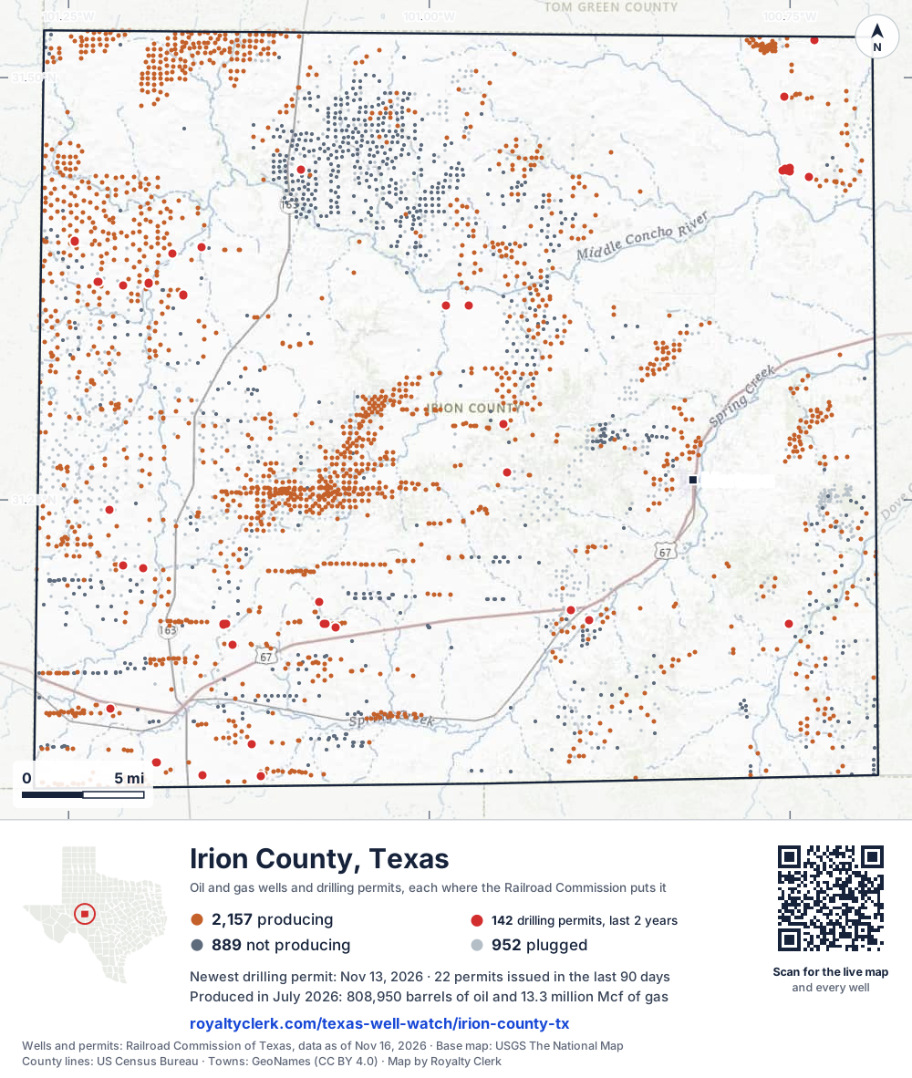
- Drilling locations142Permits issued in the last two years
- Producing wells2,157On a lease reporting production now
- Not producing889Shut in, inactive or no lease on record
- Plugged952The state's wellbore record says plugged
Sources: Railroad Commission of Texas well layers and permit files, US Census Bureau county outline, town points from GeoNames (CC BY 4.0), base map from USGS The National Map. A dot is a surface location; a horizontal well runs a mile or more from it.
3,998 wells with a location on the state's map and 142 drilling locations permitted in the last 24 months, each where the Railroad Commission puts it.
A permit is not a well.
Wells near each town in Irion County
Wells within 10 miles of each town, on either side of the county line.
Use this map on your site
You may show this map on any site, unchanged. Keep the credit line and its link to Royalty Clerk under the map. The picture updates by itself as the state records new wells and permits.
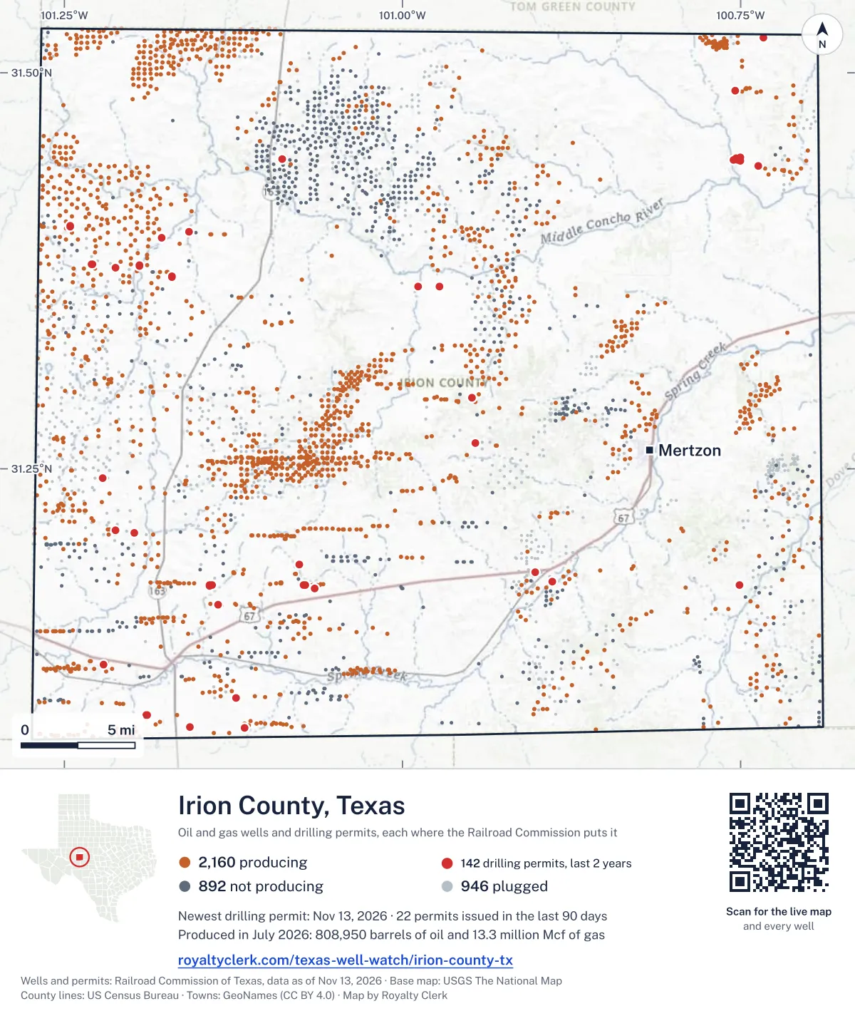
<a href="https://royaltyclerk.com/texas-well-watch/irion-county-tx"><img src="https://royaltyclerk.com/maps/county-wells/irion-county-tx.svg" alt="Map of Irion County, Texas, with 3,998 oil and gas wells and 142 recent drilling locations as dots." width="1000" height="1182" loading="lazy" style="max-width:100%;height:auto;border:0"></a>
<p style="margin:4px 0 0;font-size:14px">Map: <a href="https://royaltyclerk.com/texas-well-watch/irion-county-tx">Irion County, Texas oil and gas wells</a> by Royalty Clerk, from Railroad Commission of Texas records</p>
The last twelve months
Month by month in Irion County
| Month | Permits | Completions | First production |
|---|---|---|---|
| Nov 2026 | 3 | 0 | 0 |
| Oct 2026 | 17 | 0 | 0 |
| Sep 2026 | 2 | 1 | 0 |
| Aug 2026 | 0 | 0 | 1 |
| Jul 2026 | 1 | 14 | 0 |
| Jun 2026 | 7 | 12 | 2 |
| May 2026 | 19 | 0 | 1 |
| Apr 2026 | 9 | 4 | 3 |
| Mar 2026 | 7 | 9 | 9 |
| Feb 2026 | 0 | 8 | 4 |
| Jan 2026 | 8 | 9 | 2 |
| Dec 2025 | 0 | 1 | 0 |
| Nov 2025 | 0 | 2 | 0 |
Counted from November 18, 2025 to November 13, 2026, so the first and last months are partial. Source: Railroad Commission of Texas data sets.
Free, no sign-in
The newest drilling permits in Irion County
| Issued | Lease and well | Operator | Drilling began | Depth, ft | API number | Coordinates | Permit |
|---|---|---|---|---|---|---|---|
| 2026-11-13 | ANTELOPE DRAW BZ S01 3Hnew drill · horizontalTriple Crown Resources, LLCAPI 42-235-36807 · permit 092007731.37702, -101.211909,000 ft | Triple Crown Resources, LLC | |||||
| 2026-11-13 | ANTELOPE DRAW BZ S01 2Hnew drill · horizontalTriple Crown Resources, LLCAPI 42-235-36806 · permit 092007631.37703, -101.211969,000 ft | Triple Crown Resources, LLC | |||||
| 2026-11-13 | ANTELOPE DRAW BZ S01 1Hnew drill · horizontalTriple Crown Resources, LLCAPI 42-235-36805 · permit 092007531.37705, -101.212029,000 ft | Triple Crown Resources, LLC | |||||
| 2026-10-27 | DALLAS 1019Hnew drill · horizontalDallas Production Company LLCAPI 42-235-36802 · permit 091960431.17454, -101.06485drilling began 2026-10-30 · 9,000 ft | Dallas Production Company LLC | |||||
| 2026-10-26 | DALLAS 1018Hnew drill · horizontalDallas Production Company LLCAPI 42-235-36801 · permit 091960331.17454, -101.06491drilling began 2026-10-29 · 9,000 ft | Dallas Production Company LLC | |||||
| 2026-10-26 | DALLAS 1017Hnew drill · horizontalDallas Production Company LLCAPI 42-235-36804 · permit 091958931.17454, -101.06498drilling began 2026-10-28 · 9,000 ft | Dallas Production Company LLC | |||||
| 2026-10-26 | DALLAS 1016Hnew drill · horizontalDallas Production Company LLCAPI 42-235-36803 · permit 091958731.17454, -101.06504drilling began 2026-10-27 · 9,000 ft | Dallas Production Company LLC | |||||
| 2026-10-22 | EIGHTER EZ S865Hnew drill · horizontalTriple Crown Resources, LLCAPI 42-235-36800 · permit 091946031.36530, -100.98817drilling began 2026-10-25 · 9,000 ft | Triple Crown Resources, LLC | |||||
| 2026-10-22 | EIGHTER D S864Hnew drill · horizontalTriple Crown Resources, LLCAPI 42-235-36799 · permit 091945931.36530, -100.98823drilling began 2026-10-24 · 9,000 ft | Triple Crown Resources, LLC | |||||
| 2026-10-22 | EIGHTER C S863Hnew drill · horizontalTriple Crown Resources, LLCAPI 42-235-36797 · permit 091945731.36530, -100.98830drilling began 2026-10-23 · 9,000 ft | Triple Crown Resources, LLC | |||||
| 2026-10-22 | EIGHTER B S862Hnew drill · horizontalTriple Crown Resources, LLCAPI 42-235-36796 · permit 091945331.36530, -100.98836drilling began 2026-10-23 · 9,000 ft | Triple Crown Resources, LLC | |||||
| 2026-10-22 | EIGHTER A S861Hnew drill · horizontalTriple Crown Resources, LLCAPI 42-235-36795 · permit 091945131.36530, -100.98842drilling began 2026-10-22 · 9,000 ft | Triple Crown Resources, LLC | |||||
| 2026-10-21 | UNIVERSITY 40 A 0405WCnew drill · horizontalSem Operating Company LLCAPI 42-235-36794 · permit 091938431.08689, -101.1573510,000 ft | Sem Operating Company LLC | |||||
| 2026-10-21 | UNIVERSITY 40 A 0403WCnew drill · horizontalSem Operating Company LLCAPI 42-235-36793 · permit 091938331.08689, -101.1574410,000 ft | Sem Operating Company LLC | |||||
| 2026-10-07 | ROCKER B 86F 6Hnew drill · horizontalPioneer Natural Res. USA, Inc.API 42-235-36792 · permit 091839731.37114, -101.170208,715 ft | Pioneer Natural Res. USA, Inc. | |||||
| 2026-10-07 | ROCKER B 86E 5Hnew drill · horizontalPioneer Natural Res. USA, Inc.API 42-235-36791 · permit 091839631.37118, -101.170258,715 ft | Pioneer Natural Res. USA, Inc. | |||||
| 2026-10-07 | ROCKER B 86D 4Hnew drill · horizontalPioneer Natural Res. USA, Inc.API 42-235-36790 · permit 091839531.37123, -101.170298,715 ft | Pioneer Natural Res. USA, Inc. | |||||
| 2026-10-07 | ROCKER B 86C 3Hnew drill · horizontalPioneer Natural Res. USA, Inc.API 42-235-36789 · permit 091839431.37127, -101.170338,715 ft | Pioneer Natural Res. USA, Inc. | |||||
| 2026-10-07 | ROCKER B 86B 2Hnew drill · horizontalPioneer Natural Res. USA, Inc.API 42-235-36788 · permit 091839331.37131, -101.170378,715 ft | Pioneer Natural Res. USA, Inc. | |||||
| 2026-10-07 | ROCKER B 86A 1Hnew drill · horizontalPioneer Natural Res. USA, Inc.API 42-235-36787 · permit 091839231.37135, -101.170418,715 ft | Pioneer Natural Res. USA, Inc. | |||||
| 2026-09-01 | CAMRYN E 5Hnew drill · horizontalHibernia Resources IV, LLCAPI 42-235-36786 · permit 091818231.52240, -100.733209,000 ft | Hibernia Resources IV, LLC | |||||
| 2026-09-01 | CAMRYN D 4Hnew drill · horizontalHibernia Resources IV, LLCAPI 42-235-36785 · permit 091816831.52240, -100.733279,000 ft | Hibernia Resources IV, LLC | |||||
| 2026-07-14 | UNIVERSITY 40 1102WAnew drill · horizontalSem Operating Company LLCAPI 42-235-36784 · permit 091710631.09453, -101.18915drilling began 2026-07-24 · 10,000 ft | Sem Operating Company LLC | |||||
| 2026-06-15 | DEL BOCA VISTA A 5Hnew drill · horizontalPermian Resources Operating, LLCAPI 42-235-36777 · permit 091633731.20953, -101.19825drilling began 2026-07-30 · 13,000 ft | Permian Resources Operating, LLC | |||||
| 2026-06-11 | LITTLE JOE S866Hnew drill · horizontalTriple Crown Resources, LLCAPI 42-235-36783 · permit 091632931.36525, -100.972609,000 ft | Triple Crown Resources, LLC | |||||
| 2026-06-11 | LITTLE JOE S864Hnew drill · horizontalTriple Crown Resources, LLCAPI 42-235-36782 · permit 091632831.36525, -100.97266drilling began 2026-10-16 · 9,000 ft | Triple Crown Resources, LLC | |||||
| 2026-06-11 | LITTLE JOE S863Hnew drill · horizontalTriple Crown Resources, LLCAPI 42-235-36781 · permit 091632731.36525, -100.97273drilling began 2026-10-15 · 9,000 ft | Triple Crown Resources, LLC | |||||
| 2026-06-11 | LITTLE JOE S862Hnew drill · horizontalTriple Crown Resources, LLCAPI 42-235-36780 · permit 091632631.36526, -100.97279drilling began 2026-10-14 · 9,000 ft | Triple Crown Resources, LLC | |||||
| 2026-06-11 | LITTLE JOE S861Hnew drill · horizontalTriple Crown Resources, LLCAPI 42-235-36779 · permit 091632531.36526, -100.97286drilling began 2026-10-13 · 9,000 ft | Triple Crown Resources, LLC | |||||
| 2026-06-11 | LITTLE JOE S861Hnew drill · horizontalTriple Crown Resources, LLCAPI 42-235-36778 · permit 091632431.36526, -100.972929,000 ft | Triple Crown Resources, LLC | |||||
| 2026-05-29 | JUJYFRUIT D 4Hnew drill · horizontalPermian Resources Operating, LLCAPI 42-235-36776 · permit 091598631.20954, -101.19815drilling began 2026-07-31 · 13,000 ft | Permian Resources Operating, LLC | |||||
| 2026-05-29 | JUJYFRUIT C 3Hnew drill · horizontalPermian Resources Operating, LLCAPI 42-235-36775 · permit 091598431.20953, -101.19836drilling began 2026-07-30 · 13,000 ft | Permian Resources Operating, LLC | |||||
| 2026-05-29 | JUJYFRUIT B 2Hnew drill · horizontalPermian Resources Operating, LLCAPI 42-235-36774 · permit 091598231.21135, -101.21213drilling began 2026-06-29 · 13,000 ft | Permian Resources Operating, LLC | |||||
| 2026-05-29 | JUJYFRUIT A 1Hnew drill · horizontalPermian Resources Operating, LLCAPI 42-235-36773 · permit 091597331.21135, -101.21223drilling began 2026-06-28 · 13,000 ft | Permian Resources Operating, LLC | |||||
| 2026-05-20 | TEPEE DRAW CE N3033 6Hnew drill · horizontalTriple Crown Resources, LLCAPI 42-235-36772 · permit 091569531.39584, -101.17798drilling began 2026-08-04 · 9,000 ft | Triple Crown Resources, LLC | |||||
| 2026-05-20 | TEPEE DRAW CE N3033 5Hnew drill · horizontalTriple Crown Resources, LLCAPI 42-235-36771 · permit 091569431.39581, -101.17803drilling began 2026-08-03 · 9,000 ft | Triple Crown Resources, LLC | |||||
| 2026-05-20 | TEPEE DRAW CE N3033 4Hnew drill · horizontalTriple Crown Resources, LLCAPI 42-235-36770 · permit 091569331.39577, -101.17808drilling began 2026-08-02 · 9,000 ft | Triple Crown Resources, LLC | |||||
| 2026-05-20 | TEPEE DRAW CE N3033 3Hnew drill · horizontalTriple Crown Resources, LLCAPI 42-235-36769 · permit 091569231.39574, -101.17813drilling began 2026-08-01 · 9,000 ft | Triple Crown Resources, LLC | |||||
| 2026-05-20 | TEPEE DRAW CE N3033 2Hnew drill · horizontalTriple Crown Resources, LLCAPI 42-235-36768 · permit 091569131.39570, -101.17818drilling began 2026-07-31 · 9,000 ft | Triple Crown Resources, LLC | |||||
| 2026-05-20 | TEPEE DRAW CE N3033 1Hnew drill · horizontalTriple Crown Resources, LLCAPI 42-235-36767 · permit 091569031.39567, -101.17823drilling began 2026-07-30 · 9,000 ft | Triple Crown Resources, LLC | |||||
| 2026-05-11 | UNIVERSITY 40 E 1803WCnew drill · horizontalSem Operating Company LLCAPI 42-235-36766 · permit 091543031.10543, -101.12282drilling began 2026-05-19 · 10,000 ft | Sem Operating Company LLC | |||||
| 2026-05-08 | UNIVERSITY 40 E 1803WBnew drill · horizontalSem Operating Company LLCAPI 42-235-36765 · permit 091542931.10543, -101.12291drilling began 2026-05-18 · 10,000 ft | Sem Operating Company LLC | |||||
| 2026-05-05 | ANTELOPE DRAW BD N03 7Hnew drill · horizontalTriple Crown Resources, LLCAPI 42-235-36764 · permit 091523231.37827, -101.19435drilling began 2026-06-10 · 9,000 ft | Triple Crown Resources, LLC | |||||
| 2026-05-05 | ANTELOPE DRAW BD N03 6Hnew drill · horizontalTriple Crown Resources, LLCAPI 42-235-36763 · permit 091523031.37827, -101.19442drilling began 2026-06-10 · 9,000 ft | Triple Crown Resources, LLC | |||||
| 2026-05-05 | ANTELOPE DRAW BD N03 5Hnew drill · horizontalTriple Crown Resources, LLCAPI 42-235-36762 · permit 091522931.37827, -101.19448drilling began 2026-06-09 · 9,000 ft | Triple Crown Resources, LLC | |||||
| 2026-05-05 | ANTELOPE DRAW BD N03 4Hnew drill · horizontalTriple Crown Resources, LLCAPI 42-235-36761 · permit 091522831.37827, -101.19454drilling began 2026-06-08 · 9,000 ft | Triple Crown Resources, LLC | |||||
| 2026-05-05 | ANTELOPE DRAW BD N03 3Hnew drill · horizontalTriple Crown Resources, LLCAPI 42-235-36760 · permit 091522731.37827, -101.19461drilling began 2026-06-07 · 9,000 ft | Triple Crown Resources, LLC | |||||
| 2026-05-05 | ANTELOPE DRAW BD N03 2Hnew drill · horizontalTriple Crown Resources, LLCAPI 42-235-36759 · permit 091522631.37827, -101.19467drilling began 2026-06-05 · 9,000 ft | Triple Crown Resources, LLC | |||||
| 2026-05-05 | ANTELOPE DRAW BD N03 1Hnew drill · horizontalTriple Crown Resources, LLCAPI 42-235-36758 · permit 091522531.37827, -101.19474drilling began 2026-06-04 · 9,000 ft | Triple Crown Resources, LLC | |||||
| 2026-04-16 | BIG JAKE N408Hnew drill · horizontalTriple Crown Resources, LLCAPI 42-235-36757 · permit 091484631.17608, -101.14271drilling began 2026-04-16 · 9,000 ft | Triple Crown Resources, LLC |
These are the newest 50 of 229 permits on file for Irion County. The rest follow, 50 to a page.
A permit is permission to drill, not a well. Source: Railroad Commission of Texas drilling permit files.
Year by year
Drilling permits issued in Irion County, by year
| Year | Permits issued |
|---|---|
| 2026 so far | 73 |
| 2025 | 49 |
| 2024 | 80 |
| 2023 | 20 |
| 2022 | 3 |
| 2018 | 3 |
| 2014 | 1 |
Counted from the permit files we hold, which start in 2014; that first year may be partial. Source: Railroad Commission of Texas drilling permit files.
The latest
The most recent records
| Date | What, who and where |
|---|---|
| 2026-11-13 | Permit issued: Triple Crown Resources, LLCANTELOPE DRAW BZ S01 · A-59 · permit 0920077 |
| 2026-11-13 | Permit issued: Triple Crown Resources, LLCANTELOPE DRAW BZ S01 · A-59 · permit 0920076 |
| 2026-11-13 | Permit issued: Triple Crown Resources, LLCANTELOPE DRAW BZ S01 · A-59 · permit 0920075 |
| 2026-10-27 | Permit issued: Dallas Production Company LLCDALLAS · A-669 · permit 0919604 |
| 2026-10-26 | Permit issued: Dallas Production Company LLCDALLAS · A-669 · permit 0919603 |
| 2026-10-26 | Permit issued: Dallas Production Company LLCDALLAS · A-669 · permit 0919589 |
| 2026-10-26 | Permit issued: Dallas Production Company LLCDALLAS · A-669 · permit 0919587 |
| 2026-10-22 | Permit issued: Triple Crown Resources, LLCEIGHTER EZ · A-1056 · permit 0919460 |
| 2026-10-22 | Permit issued: Triple Crown Resources, LLCEIGHTER D · A-1056 · permit 0919459 |
| 2026-10-22 | Permit issued: Triple Crown Resources, LLCEIGHTER C · A-1056 · permit 0919457 |
| 2026-10-22 | Permit issued: Triple Crown Resources, LLCEIGHTER B · A-1056 · permit 0919453 |
| 2026-10-22 | Permit issued: Triple Crown Resources, LLCEIGHTER A · A-1056 · permit 0919451 |
| 2026-10-21 | Permit issued: Sem Operating Company LLCUNIVERSITY 40 A · A-U21 · permit 0919384 |
| 2026-10-21 | Permit issued: Sem Operating Company LLCUNIVERSITY 40 A · A-U21 · permit 0919383 |
| 2026-10-07 | Permit issued: Pioneer Natural Res. USA, Inc.ROCKER B 86F · A-1032 · permit 0918397 |
Coming up
First checks coming due in Irion County
- MUNSON '17', Munson, David M. Inc.by November 28, 2026
- UNIVERSITY 40, Sem Operating Company LLCby November 28, 2026
- UNIVERSITY 40, Sem Operating Company LLCby November 28, 2026
- DALLAS, Dallas Production Company LLCby November 28, 2026
- UNIVERSITY 40, Sem Operating Company LLCby November 28, 2026
- UNIVERSITY 40, Sem Operating Company LLCby November 28, 2026
- Bastogne Unit, Moriah Operating,llcby December 29, 2026
Follow it
Watch Irion County, or one abstract
What do you want to follow?
Where the land is. Your deed or lease names it.
For example A-1119, or Bush, or T&P 38. Your deed or the tax bill has it.
Other counties
Drilling activity in other counties
Related
Related
- ToolTexas well watchPermit, completion, first production and when the first check is due.
- ToolIs this buyout offer fair?The offer as months of your income, what the acres mean, and the questions to ask.
- ToolIs this lease offer good?Bonus and royalty against the county, and a scan of the lease's clauses.
- Texas dataTexas operator changesWho took over whose leases in the last 24 months.
- ToolLate payment interestDeadlines and the interest a late payment earns.
- Texas dataTexas oil and gas atlas254 counties, every lease, operator and field.
FAQ
Questions people ask
How many wells were permitted in Irion County in the last year?
The Railroad Commission issued 73 drilling permits in Irion County in the twelve months to November 13, 2026, and recorded 60 completions and 22 first-production reports. A permit is permission to drill, not a well.
How do I get an alert when a permit is issued near my land in Irion County?
Choose your abstract on this page, or the whole county, and sign in. You get one email a week, only when something new is recorded after you sign up. The alert says whether an event is on an interest in your Mineral File, on a place you follow, or only nearby.
When is my first royalty check due after a new well?
Natural Resources Code section 91.402(a) says on or before 120 days after the end of the month of first sale of production from the well. The state's first-production month is the closest public marker, so the date on this page is the earliest, not a certainty.
Got a new well on your land?
The first check is due within 120 days after the end of the month of first sale.
Sources
Primary sources, opened on 29 September 2026. Statute text is the current version on statutes.capitol.texas.gov.