
Live Oak County, Texas
Live Oak County drilling permits: what the state recorded
- 83drilling permits
- 80completions
- 30first-production reports
- in the last twelve months
Wells by coordinates
Oil wells and drilling locations in Live Oak County
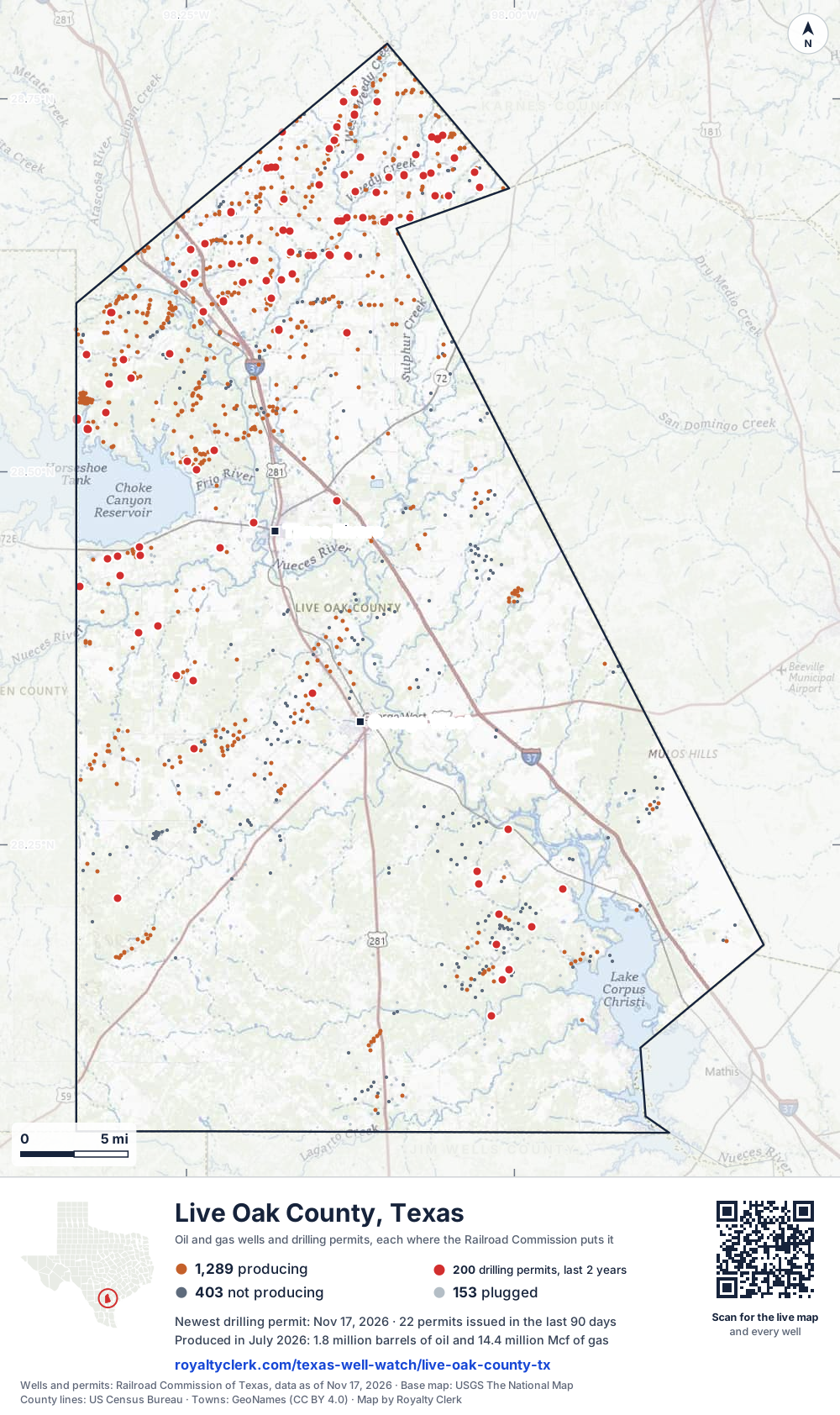
- Drilling locations200Permits issued in the last two years
- Producing wells1,289On a lease reporting production now
- Not producing403Shut in, inactive or no lease on record
- Plugged153The state's wellbore record says plugged
Sources: Railroad Commission of Texas well layers and permit files, US Census Bureau county outline, town points from GeoNames (CC BY 4.0), base map from USGS The National Map. A dot is a surface location; a horizontal well runs a mile or more from it.
1,845 wells with a location on the state's map and 200 drilling locations permitted in the last 24 months, each where the Railroad Commission puts it.
A permit is not a well.
Live Oak County is one of the 27 counties of the Eagle Ford Shale
Wells near each town in Live Oak County
Wells within 10 miles of each town, on either side of the county line.
Use this map on your site
You may show this map on any site, unchanged. Keep the credit line and its link to Royalty Clerk under the map. The picture updates by itself as the state records new wells and permits.
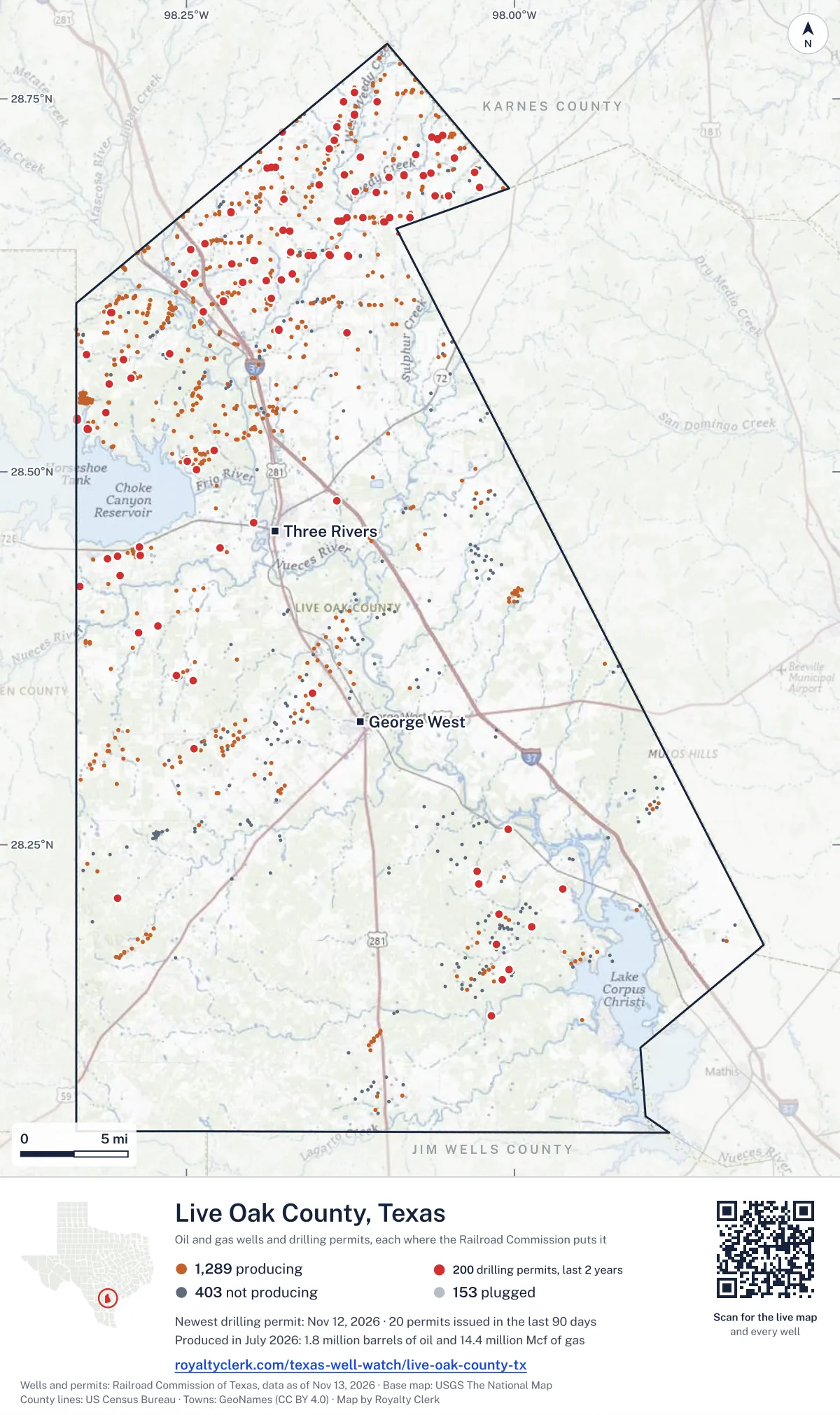
<a href="https://royaltyclerk.com/texas-well-watch/live-oak-county-tx"><img src="https://royaltyclerk.com/maps/county-wells/live-oak-county-tx.svg" alt="Map of Live Oak County, Texas, with 1,845 oil and gas wells and 200 recent drilling locations as dots." width="1000" height="1684" loading="lazy" style="max-width:100%;height:auto;border:0"></a>
<p style="margin:4px 0 0;font-size:14px">Map: <a href="https://royaltyclerk.com/texas-well-watch/live-oak-county-tx">Live Oak County, Texas oil and gas wells</a> by Royalty Clerk, from Railroad Commission of Texas records</p>
The last twelve months
Month by month in Live Oak County
| Month | Permits | Completions | First production |
|---|---|---|---|
| Nov 2026 | 7 | 0 | 0 |
| Oct 2026 | 7 | 0 | 0 |
| Sep 2026 | 8 | 0 | 0 |
| Aug 2026 | 5 | 0 | 1 |
| Jul 2026 | 10 | 3 | 1 |
| Jun 2026 | 7 | 3 | 0 |
| May 2026 | 4 | 5 | 5 |
| Apr 2026 | 7 | 6 | 5 |
| Mar 2026 | 3 | 23 | 11 |
| Feb 2026 | 2 | 20 | 5 |
| Jan 2026 | 7 | 11 | 2 |
| Dec 2025 | 10 | 8 | 0 |
| Nov 2025 | 6 | 1 | 0 |
Counted from November 19, 2025 to November 17, 2026, so the first and last months are partial. Source: Railroad Commission of Texas data sets.
Free, no sign-in
The newest drilling permits in Live Oak County
| Issued | Lease and well | Operator | Drilling began | Depth, ft | API number | Coordinates | Permit |
|---|---|---|---|---|---|---|---|
| 2026-11-17 | GONZALES-ESK N SA C 1new drill · horizontalBurlington Resources O & G Co LPAPI 42-297-36616 · permit 091994317,500 ft | Burlington Resources O & G Co LP | |||||
| 2026-11-16 | GONZALES-ESK W-N SA A 1new drill · horizontalBurlington Resources O & G Co LPAPI 42-297-36614 · permit 091994117,500 ft | Burlington Resources O & G Co LP | |||||
| 2026-11-12 | GONZALES UNIT 3new drill · horizontalBurlington Resources O & G Co LPAPI 42-297-36612 · permit 091994028.70042, -98.0635717,500 ft | Burlington Resources O & G Co LP | |||||
| 2026-11-12 | GONZALES UNIT 2new drill · horizontalBurlington Resources O & G Co LPAPI 42-297-36611 · permit 091993928.70040, -98.0637617,500 ft | Burlington Resources O & G Co LP | |||||
| 2026-11-10 | ARNOLD UNIT B 1recompletion · horizontalBurlington Resources O & G Co LPAPI 42-297-35087 · permit 091995728.68471, -98.0502812,841 ft | Burlington Resources O & G Co LP | |||||
| 2026-11-05 | PLOMERO-IVAS-TS USW D 4new drill · horizontalBurlington Resources O & G Co LPAPI 42-297-36613 · permit 091992528.56290, -98.2923517,500 ft | Burlington Resources O & G Co LP | |||||
| 2026-11-02 | GRANBERRY 'A' UNIT 2new drill · verticalViper S.w.d., LLCAPI 42-297-36610 · permit 091985428.20334, -98.012125,800 ft | Viper S.w.d., LLC | |||||
| 2026-10-23 | JO ANN ESSE UNIT D 1recompletion · horizontalBurlington Resources O & G Co LPAPI 42-297-34959 · permit 091941728.71629, -98.1408811,429 ft | Burlington Resources O & G Co LP | |||||
| 2026-10-20 | SCHROEDER UNIT B 1recompletion · horizontalBurlington Resources O & G Co LPAPI 42-297-35078 · permit 091946928.73943, -98.1219511,437 ft | Burlington Resources O & G Co LP | |||||
| 2026-10-20 | BURGESS UNIT A 1recompletion · horizontalBurlington Resources O & G Co LPAPI 42-297-34956 · permit 091946628.72568, -98.0548611,911 ft | Burlington Resources O & G Co LP | |||||
| 2026-10-16 | SHORE TRUST 1new drill · verticalRoyal Production Company, Inc.API 42-297-36609 · permit 091932128.13547, -98.017265,750 ft | Royal Production Company, Inc. | |||||
| 2026-10-09 | THREE RIVERS UNIT A 4Hnew drill · horizontalCaturus Energy, LLCAPI 42-297-36608 · permit 091917028.39668, -98.2717617,500 ft | Caturus Energy, LLC | |||||
| 2026-10-09 | THREE RIVERS UNIT A 3Hnew drill · horizontalCaturus Energy, LLCAPI 42-297-36607 · permit 091916928.39668, -98.2718317,500 ft | Caturus Energy, LLC | |||||
| 2026-10-09 | THREE RIVERS UNIT A 2Hnew drill · horizontalCaturus Energy, LLCAPI 42-297-36606 · permit 091916128.39668, -98.2718917,500 ft | Caturus Energy, LLC | |||||
| 2026-09-25 | MCNEILL RANCH 1new drill · verticalPaloma Operating, LLCAPI 42-297-36605 · permit 091887228.19488, -97.987076,000 ft | Paloma Operating, LLC | |||||
| 2026-09-21 | WHITSETT-TAYLOR-MASS SA D 1new drill · horizontalMarathon Oil Ef LLCAPI 42-297-36601 · permit 091839928.62587, -98.2520517,500 ft | Marathon Oil Ef LLC | |||||
| 2026-09-21 | WHITSETT-TAYLOR-MASS SA C 1new drill · horizontalMarathon Oil Ef LLCAPI 42-297-36602 · permit 091839828.62591, -98.2520917,500 ft | Marathon Oil Ef LLC | |||||
| 2026-09-21 | WHITSETT-TAYLOR-MASS SA B 1new drill · horizontalMarathon Oil Ef LLCAPI 42-297-36600 · permit 091839128.62583, -98.2520017,500 ft | Marathon Oil Ef LLC | |||||
| 2026-09-21 | WHITSETT-TAYLOR-MASS SA A 1new drill · horizontalMarathon Oil Ef LLCAPI 42-297-36599 · permit 091839028.62579, -98.2519617,500 ft | Marathon Oil Ef LLC | |||||
| 2026-09-17 | WILKINS, ET AL 1new drill · verticalSandalwood Exploration, L.P.API 42-297-36604 · permit 091866428.43018, -98.30070drilling began 2026-10-05 · 8,200 ft | Sandalwood Exploration, L.P. | |||||
| 2026-09-17 | 1893 D-FRANK MALEK SA A 1new drill · horizontalBurlington Resources O & G Co LPAPI 42-297-36603 · permit 091846828.64548, -98.1408617,500 ft | Burlington Resources O & G Co LP | |||||
| 2026-09-16 | SULLIVAN UNIT 10recompletion · verticalGouger Oil Company, LLCAPI 42-297-33340 · permit 091861628.31471, -98.2441210,500 ft | Gouger Oil Company, LLC | |||||
| 2026-08-03 | 1893 OIL & GAS, LTD. UNIT D 12new drill · horizontalBurlington Resources O & G Co LPAPI 42-297-36598 · permit 091753828.64548, -98.1409217,500 ft | Burlington Resources O & G Co LP | |||||
| 2026-08-03 | 1893 OIL & GAS, LTD. UNIT A 4new drill · horizontalBurlington Resources O & G Co LPAPI 42-297-36597 · permit 091753728.64548, -98.1409817,500 ft | Burlington Resources O & G Co LP | |||||
| 2026-08-03 | 1893 OIL & GAS, LTD. UNIT A 3new drill · horizontalBurlington Resources O & G Co LPAPI 42-297-36596 · permit 091753628.64548, -98.1410517,500 ft | Burlington Resources O & G Co LP | |||||
| 2026-08-03 | 1893 OIL & GAS LTD UNIT A 13new drill · horizontalBurlington Resources O & G Co LPAPI 42-297-36594 · permit 091745828.64488, -98.1569317,500 ft | Burlington Resources O & G Co LP | |||||
| 2026-08-03 | 1893 OIL & GAS LTD UNIT A 12new drill · horizontalBurlington Resources O & G Co LPAPI 42-297-36595 · permit 091745628.64488, -98.1570017,500 ft | Burlington Resources O & G Co LP | |||||
| 2026-07-31 | TAYLOR FARMS, INC. 23new drill · horizontalBurlington Resources O & G Co LPAPI 42-297-36593 · permit 091745428.64488, -98.1570617,500 ft | Burlington Resources O & G Co LP | |||||
| 2026-07-31 | TAYLOR FARMS, INC. 18new drill · horizontalBurlington Resources O & G Co LPAPI 42-297-36592 · permit 091745028.64488, -98.1571217,500 ft | Burlington Resources O & G Co LP | |||||
| 2026-07-28 | F MALEK L-1893-KOER SA B 1new drill · horizontalBurlington Resources O & G Co LPAPI 42-297-36590 · permit 091734528.59515, -98.1794917,500 ft | Burlington Resources O & G Co LP | |||||
| 2026-07-24 | F MALEK L-1893-KOER SA C 1new drill · horizontalBurlington Resources O & G Co LPAPI 42-297-36591 · permit 091735028.59511, -98.1795417,500 ft | Burlington Resources O & G Co LP | |||||
| 2026-07-24 | F MALEK L-1893-KOER SA A 1new drill · horizontalBurlington Resources O & G Co LPAPI 42-297-36589 · permit 091734428.59519, -98.1794517,500 ft | Burlington Resources O & G Co LP | |||||
| 2026-07-21 | SANGER HEIRS 226 1new drill · verticalHydrocarbon Operating, Inc.API 42-297-36588 · permit 091725628.21439, -98.302358,000 ft | Hydrocarbon Operating, Inc. | |||||
| 2026-07-20 | F. MALEK UNIT U-M ULW 1new drill · horizontalBurlington Resources O & G Co LPAPI 42-297-36587 · permit 091706928.66801, -98.1318717,500 ft | Burlington Resources O & G Co LP | |||||
| 2026-07-17 | F. MALEK UNIT U 3new drill · horizontalBurlington Resources O & G Co LPAPI 42-297-36586 · permit 091706328.66801, -98.1319317,500 ft | Burlington Resources O & G Co LP | |||||
| 2026-07-16 | F. MALEK UNIT M 3new drill · horizontalBurlington Resources O & G Co LPAPI 42-297-36585 · permit 091705628.66801, -98.1318117,500 ft | Burlington Resources O & G Co LP | |||||
| 2026-07-16 | F. MALEK UNIT M 2new drill · horizontalBurlington Resources O & G Co LPAPI 42-297-36584 · permit 091705428.66801, -98.1317417,500 ft | Burlington Resources O & G Co LP | |||||
| 2026-06-26 | RICHEY 1re-entry · verticalAurora Resources CorporationAPI 42-297-33718 · permit 091667128.23206, -98.028174,900 ft | Aurora Resources Corporation | |||||
| 2026-06-24 | BENNETT 1new drill · verticalCimarron Engineering, LLCAPI 42-297-36583 · permit 091661428.35174, -98.15408drilling began 2026-08-18 · 8,200 ft | Cimarron Engineering, LLC | |||||
| 2026-06-22 | C N FREEMAN 8new drill · verticalAurora Resources CorporationAPI 42-297-36582 · permit 091653728.22399, -98.027135,000 ft | Aurora Resources Corporation | |||||
| 2026-06-05 | PLOMERO RANCH 48new drill · horizontalBurlington Resources O & G Co LPAPI 42-297-36578 · permit 091577928.53960, -98.3112917,500 ft | Burlington Resources O & G Co LP | |||||
| 2026-06-03 | PLOMERO RANCH 49new drill · horizontalBurlington Resources O & G Co LPAPI 42-297-36579 · permit 091578028.53954, -98.3113017,500 ft | Burlington Resources O & G Co LP | |||||
| 2026-06-01 | PLOMERO RANCH 51new drill · horizontalBurlington Resources O & G Co LPAPI 42-297-36581 · permit 091578228.53944, -98.3113417,500 ft | Burlington Resources O & G Co LP | |||||
| 2026-06-01 | PLOMERO RANCH 50new drill · horizontalBurlington Resources O & G Co LPAPI 42-297-36580 · permit 091578128.53949, -98.3113217,500 ft | Burlington Resources O & G Co LP | |||||
| 2026-05-08 | STATE-COLV-LIVE SA A 1new drill · horizontalBurlington Resources O & G Co LPAPI 42-297-36577 · permit 091517728.66765, -98.09934drilling began 2026-05-23 · 17,500 ft | Burlington Resources O & G Co LP | |||||
| 2026-05-05 | BETTY K-LIVE-MAY SA A 1new drill · horizontalBurlington Resources O & G Co LPAPI 42-297-36576 · permit 091519428.66765, -98.0991617,500 ft | Burlington Resources O & G Co LP | |||||
| 2026-05-05 | LIVE BEE-MAY SA A 1new drill · horizontalBurlington Resources O & G Co LPAPI 42-297-36574 · permit 091518128.66765, -98.09922drilling began 2026-05-22 · 17,500 ft | Burlington Resources O & G Co LP | |||||
| 2026-05-01 | BETTY K A-B SA A 1new drill · horizontalBurlington Resources O & G Co LPAPI 42-297-36575 · permit 091519328.66765, -98.09928drilling began 2026-05-25 · 17,500 ft | Burlington Resources O & G Co LP | |||||
| 2026-04-23 | SCHWARTZ 6new drill · verticalAurora Resources CorporationAPI 42-297-36573 · permit 091500128.44380, -98.28554drilling began 2026-04-25 · 1,500 ft | Aurora Resources Corporation | |||||
| 2026-04-10 | USA LARK 5CHnew drill · horizontalSilver Hill Energy Operating LLCAPI 42-297-36571 · permit 091454828.53598, -98.33361drilling began 2026-08-24 · 11,400 ft | Silver Hill Energy Operating LLC |
These are the newest 50 of 325 permits on file for Live Oak County. The rest follow, 50 to a page.
A permit is permission to drill, not a well. Source: Railroad Commission of Texas drilling permit files.
Year by year
Drilling permits issued in Live Oak County, by year
| Year | Permits issued |
|---|---|
| 2026 so far | 67 |
| 2025 | 128 |
| 2024 | 86 |
| 2023 | 28 |
| 2022 | 6 |
| 2021 | 5 |
| 2018 | 4 |
| 2011 | 1 |
Counted from the permit files we hold, which start in 2011; that first year may be partial. Source: Railroad Commission of Texas drilling permit files.
The latest
The most recent records
| Date | What, who and where |
|---|---|
| 2026-11-17 | Permit issued: Burlington Resources O & G Co LPGONZALES-ESK N SA C · A-401 · permit 0919943 |
| 2026-11-16 | Permit issued: Burlington Resources O & G Co LPGONZALES-ESK W-N SA A · A-401 · permit 0919941 |
| 2026-11-12 | Permit issued: Burlington Resources O & G Co LPGONZALES UNIT · A-401 · permit 0919940 |
| 2026-11-12 | Permit issued: Burlington Resources O & G Co LPGONZALES UNIT · A-401 · permit 0919939 |
| 2026-11-10 | Permit issued: Burlington Resources O & G Co LPARNOLD UNIT B · A-222 · permit 0919957 |
| 2026-11-05 | Permit issued: Burlington Resources O & G Co LPPLOMERO-IVAS-TS USW D · A-660 · permit 0919925 |
| 2026-11-02 | Permit issued: Viper S.w.d., LLCGRANBERRY 'A' UNIT · A-788 · permit 0919854 |
| 2026-10-23 | Permit issued: Burlington Resources O & G Co LPJO ANN ESSE UNIT D · A-429 · permit 0919417 |
| 2026-10-20 | Permit issued: Burlington Resources O & G Co LPSCHROEDER UNIT B · A-155 · permit 0919469 |
| 2026-10-20 | Permit issued: Burlington Resources O & G Co LPBURGESS UNIT A · A-408 · permit 0919466 |
| 2026-10-16 | Permit issued: Royal Production Company, Inc.SHORE TRUST · A-317 · permit 0919321 |
| 2026-10-09 | Permit issued: Caturus Energy, LLCTHREE RIVERS UNIT A · A-217 · permit 0919170 |
| 2026-10-09 | Permit issued: Caturus Energy, LLCTHREE RIVERS UNIT A · A-217 · permit 0919169 |
| 2026-10-09 | Permit issued: Caturus Energy, LLCTHREE RIVERS UNIT A · A-217 · permit 0919161 |
| 2026-09-25 | Permit issued: Paloma Operating, LLCMCNEILL RANCH · A-143 · permit 0918872 |
Coming up
First checks coming due in Live Oak County
- Dobie Ranch, Paloma Operating, LLCby November 28, 2026
- Three Rivers Unit H, Caturus Energy, LLCby December 29, 2026
Follow it
Watch Live Oak County, or one abstract
What do you want to follow?
Where the land is. Your deed or lease names it.
For example A-1119, or Bush, or T&P 38. Your deed or the tax bill has it.
Other counties
Drilling activity in other counties
Related
Related
- ToolTexas well watchPermit, completion, first production and when the first check is due.
- ToolIs this buyout offer fair?The offer as months of your income, what the acres mean, and the questions to ask.
- ToolIs this lease offer good?Bonus and royalty against the county, and a scan of the lease's clauses.
- Texas dataTexas operator changesWho took over whose leases in the last 24 months.
- ToolLate payment interestDeadlines and the interest a late payment earns.
- Texas dataTexas oil and gas atlas254 counties, every lease, operator and field.
FAQ
Questions people ask
How many wells were permitted in Live Oak County in the last year?
The Railroad Commission issued 83 drilling permits in Live Oak County in the twelve months to November 17, 2026, and recorded 80 completions and 30 first-production reports. A permit is permission to drill, not a well.
How do I get an alert when a permit is issued near my land in Live Oak County?
Choose your abstract on this page, or the whole county, and sign in. You get one email a week, only when something new is recorded after you sign up. The alert says whether an event is on an interest in your Mineral File, on a place you follow, or only nearby.
When is my first royalty check due after a new well?
Natural Resources Code section 91.402(a) says on or before 120 days after the end of the month of first sale of production from the well. The state's first-production month is the closest public marker, so the date on this page is the earliest, not a certainty.
Got a new well on your land?
The first check is due within 120 days after the end of the month of first sale.
Sources
Primary sources, opened on 29 September 2026. Statute text is the current version on statutes.capitol.texas.gov.