
Pecos County, Texas
Pecos County drilling permits: what the state recorded
- 108drilling permits
- 76completions
- 13first-production reports
- in the last twelve months
Wells by coordinates
Oil wells and drilling locations in Pecos County
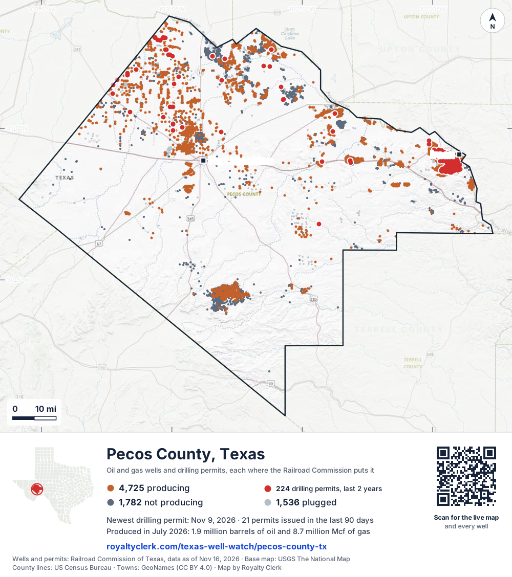
- Drilling locations224Permits issued in the last two years
- Producing wells4,725On a lease reporting production now
- Not producing1,782Shut in, inactive or no lease on record
- Plugged1,536The state's wellbore record says plugged
Sources: Railroad Commission of Texas well layers and permit files, US Census Bureau county outline, town points from GeoNames (CC BY 4.0), base map from USGS The National Map. A dot is a surface location; a horizontal well runs a mile or more from it.
8,043 wells with a location on the state's map and 224 drilling locations permitted in the last 24 months, each where the Railroad Commission puts it.
A permit is not a well.
Wells near each town in Pecos County
Wells within 10 miles of each town, on either side of the county line.
Use this map on your site
You may show this map on any site, unchanged. Keep the credit line and its link to Royalty Clerk under the map. The picture updates by itself as the state records new wells and permits.
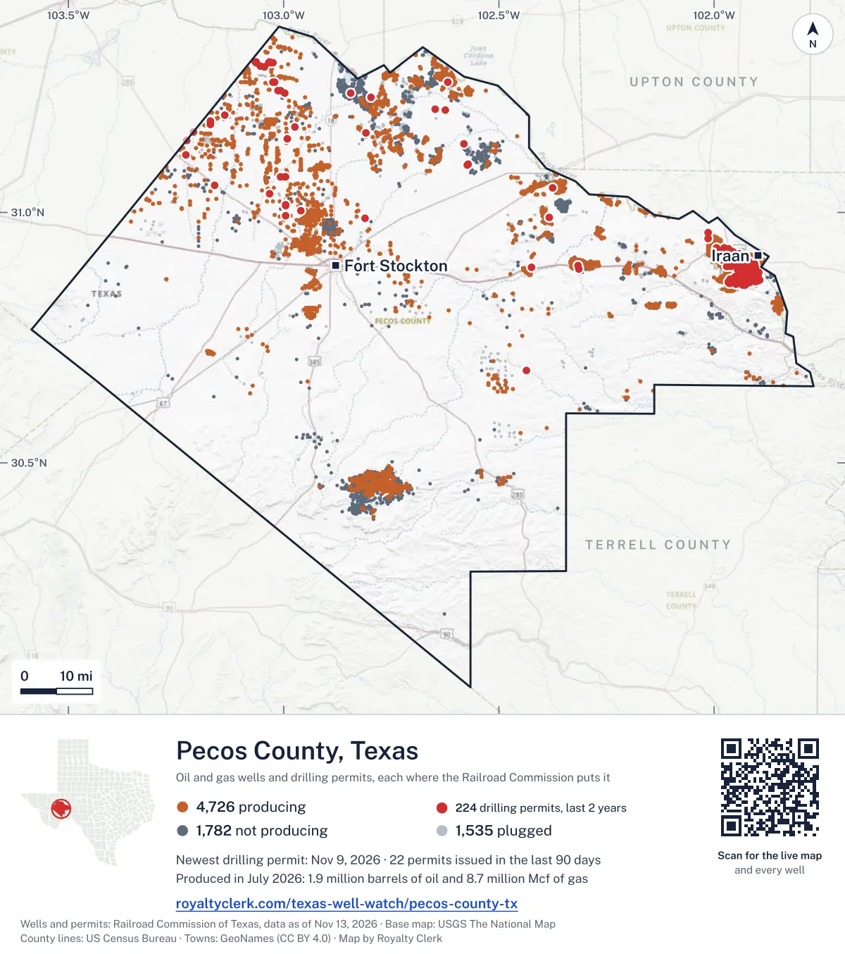
<a href="https://royaltyclerk.com/texas-well-watch/pecos-county-tx"><img src="https://royaltyclerk.com/maps/county-wells/pecos-county-tx.svg" alt="Map of Pecos County, Texas, with 8,043 oil and gas wells and 224 recent drilling locations as dots." width="1000" height="1128" loading="lazy" style="max-width:100%;height:auto;border:0"></a>
<p style="margin:4px 0 0;font-size:14px">Map: <a href="https://royaltyclerk.com/texas-well-watch/pecos-county-tx">Pecos County, Texas oil and gas wells</a> by Royalty Clerk, from Railroad Commission of Texas records</p>
The last twelve months
Month by month in Pecos County
| Month | Permits | Completions | First production |
|---|---|---|---|
| Nov 2026 | 9 | 0 | 0 |
| Oct 2026 | 5 | 0 | 0 |
| Sep 2026 | 7 | 0 | 0 |
| Aug 2026 | 2 | 3 | 0 |
| Jul 2026 | 7 | 6 | 1 |
| Jun 2026 | 21 | 4 | 0 |
| May 2026 | 26 | 10 | 0 |
| Apr 2026 | 4 | 11 | 2 |
| Mar 2026 | 10 | 16 | 5 |
| Feb 2026 | 6 | 4 | 0 |
| Jan 2026 | 1 | 8 | 1 |
| Dec 2025 | 7 | 13 | 4 |
| Nov 2025 | 3 | 1 | 0 |
Counted from November 18, 2025 to November 9, 2026, so the first and last months are partial. Source: Railroad Commission of Texas data sets.
Free, no sign-in
The newest drilling permits in Pecos County
| Issued | Lease and well | Operator | Drilling began | Depth, ft | API number | Coordinates | Permit |
|---|---|---|---|---|---|---|---|
| 2026-11-09 | FITZGERALD STATE 1recompletion · verticalPetx Operating LLCAPI 42-371-05666 · permit 091996831.25990, -102.619395,050 ft | Petx Operating LLC | |||||
| 2026-11-06 | PHOENIX STATE WA3 3Hnew drill · horizontalMongoose Energy, LLCAPI 42-371-40581 · permit 091974331.01460, -102.9948110,000 ft | Mongoose Energy, LLC | |||||
| 2026-11-06 | PHOENIX STATE WA2 2Hnew drill · horizontalMongoose Energy, LLCAPI 42-371-40580 · permit 091974131.01453, -102.9948110,000 ft | Mongoose Energy, LLC | |||||
| 2026-11-06 | PHOENIX STATE WA1 1Hnew drill · horizontalMongoose Energy, LLCAPI 42-371-40577 · permit 091973931.01445, -102.9948110,000 ft | Mongoose Energy, LLC | |||||
| 2026-11-06 | MORAN FEE 139 1new drill · verticalLongfellow Energy, LPAPI 42-371-40584 · permit 091998231.09385, -102.574165,300 ft | Longfellow Energy, LP | |||||
| 2026-11-06 | EMORY PEAK STATE 112 1new drill · verticalLongfellow Energy, LPAPI 42-371-40582 · permit 091998331.13670, -102.581385,600 ft | Longfellow Energy, LP | |||||
| 2026-11-06 | BYERS PEAK STATE 24 1new drill · verticalLongfellow Energy, LPAPI 42-371-40583 · permit 091998131.20424, -102.623646,000 ft | Longfellow Energy, LP | |||||
| 2026-11-04 | MCKINLEY STATE 138 1new drill · verticalLongfellow Energy, LPAPI 42-371-40579 · permit 091984731.09584, -102.572275,500 ft | Longfellow Energy, LP | |||||
| 2026-11-02 | KATAHDIN STATE 22 1new drill · verticalLongfellow Energy, LPAPI 42-371-40578 · permit 091984531.20577, -102.648146,200 ft | Longfellow Energy, LP | |||||
| 2026-10-16 | EXITO 4Hnew drill · horizontalHighmark Energy Operating, LLCAPI 42-371-40576 · permit 091920731.14687, -102.991899,600 ft | Highmark Energy Operating, LLC | |||||
| 2026-10-16 | EXITO 3Hnew drill · horizontalHighmark Energy Operating, LLCAPI 42-371-40575 · permit 091920631.14692, -102.991899,600 ft | Highmark Energy Operating, LLC | |||||
| 2026-10-16 | EXITO 2Hnew drill · horizontalHighmark Energy Operating, LLCAPI 42-371-40574 · permit 091920431.14698, -102.991899,600 ft | Highmark Energy Operating, LLC | |||||
| 2026-10-16 | EXITO 1Hnew drill · horizontalHighmark Energy Operating, LLCAPI 42-371-40573 · permit 091919531.14703, -102.991899,600 ft | Highmark Energy Operating, LLC | |||||
| 2026-10-13 | SMITH -A- 24Wreclass · verticalShallow Production Oper, LLCAPI 42-371-10094 · permit 091891430.94695, -102.01307354 ft | Shallow Production Oper, LLC | |||||
| 2026-09-16 | TALLBOY THUNDER 1Hnew drill · horizontalMBX Operating LLCAPI 42-371-40570 · permit 091851431.03738, -103.0332610,400 ft | MBX Operating LLC | |||||
| 2026-09-14 | THE SPICE MUST FLOW 1Hnew drill · horizontalMBX Operating LLCAPI 42-371-40569 · permit 091851531.03730, -103.0332610,400 ft | MBX Operating LLC | |||||
| 2026-09-14 | BUNKER BUSTER 1Hnew drill · horizontalMBX Operating LLCAPI 42-371-40568 · permit 091851331.03747, -103.0332610,400 ft | MBX Operating LLC | |||||
| 2026-09-09 | STEWART 15-22 4SBnew drill · horizontalBlue Arrow Operating, LLCAPI 42-371-40567 · permit 091840831.16074, -103.209059,300 ft | Blue Arrow Operating, LLC | |||||
| 2026-09-09 | STEWART 15-22 3SBnew drill · horizontalBlue Arrow Operating, LLCAPI 42-371-40566 · permit 091840731.16074, -103.209249,300 ft | Blue Arrow Operating, LLC | |||||
| 2026-09-09 | STEWART 15-22 2TBnew drill · horizontalBlue Arrow Operating, LLCAPI 42-371-40565 · permit 091840631.16074, -103.209159,950 ft | Blue Arrow Operating, LLC | |||||
| 2026-09-08 | TOBORG 33reclass · verticalShallow Production Oper, LLCAPI 42-371-33534 · permit 091827330.95953, -102.01336425 ft | Shallow Production Oper, LLC | |||||
| 2026-08-19 | YATES FIELD UNIT 98B08reclass · verticalKinder Morgan Production Co LLCAPI 42-371-33696 · permit 091789330.85966, -101.963231,999 ft | Kinder Morgan Production Co LLC | |||||
| 2026-08-17 | ATKINS STATE '26' 2recompletion · verticalMBX Operating LLCAPI 42-371-37030 · permit 091788031.15868, -102.808877,550 ft | MBX Operating LLC | |||||
| 2026-07-30 | CHERRY STATE UNIT 3228F 11Hnew drill · horizontalContinental Resources, Inc.API 42-371-40564 · permit 091730831.25972, -103.0208011,356 ft | Continental Resources, Inc. | |||||
| 2026-07-30 | CHERRY STATE UNIT 3228E 10Hnew drill · horizontalContinental Resources, Inc.API 42-371-40563 · permit 091730731.25974, -103.0208911,356 ft | Continental Resources, Inc. | |||||
| 2026-07-30 | CHERRY STATE UNIT 3228D 09Hnew drill · horizontalContinental Resources, Inc.API 42-371-40562 · permit 091730631.25975, -103.0209911,356 ft | Continental Resources, Inc. | |||||
| 2026-07-30 | CHERRY STATE UNIT 3228C 08Hnew drill · horizontalContinental Resources, Inc.API 42-371-40561 · permit 091730531.26047, -103.0254311,356 ft | Continental Resources, Inc. | |||||
| 2026-07-30 | CHERRY STATE UNIT 3228B 07Hnew drill · horizontalContinental Resources, Inc.API 42-371-40560 · permit 091730431.26048, -103.02552drilling began 2026-09-08 · 11,356 ft | Continental Resources, Inc. | |||||
| 2026-07-30 | CHERRY STATE UNIT 3228A 06Hnew drill · horizontalContinental Resources, Inc.API 42-371-40559 · permit 091730331.26050, -103.02562drilling began 2026-09-06 · 11,356 ft | Continental Resources, Inc. | |||||
| 2026-07-02 | YATES FIELD UNIT 47B14reclass · verticalKinder Morgan Production Co LLCAPI 42-371-32317 · permit 091680830.88050, -101.905781,999 ft | Kinder Morgan Production Co LLC | |||||
| 2026-06-30 | YATES FIELD UNIT 49A73reclass · horizontalKinder Morgan Production Co LLCAPI 42-371-32864 · permit 091672430.88063, -101.925691,999 ft | Kinder Morgan Production Co LLC | |||||
| 2026-06-26 | PAPERSHELL STATE UNIT 3405Hnew drill · horizontalContinental Resources, Inc.API 42-371-40558 · permit 091666331.24257, -103.0066314,040 ft | Continental Resources, Inc. | |||||
| 2026-06-26 | PAPERSHELL STATE UNIT 3404Hnew drill · horizontalContinental Resources, Inc.API 42-371-40557 · permit 091666231.24249, -103.0066514,040 ft | Continental Resources, Inc. | |||||
| 2026-06-26 | PAPERSHELL STATE UNIT 3403Hnew drill · horizontalContinental Resources, Inc.API 42-371-40556 · permit 091666131.24241, -103.0066614,040 ft | Continental Resources, Inc. | |||||
| 2026-06-26 | PAPERSHELL STATE UNIT 3402Hnew drill · horizontalContinental Resources, Inc.API 42-371-40555 · permit 091666031.24313, -103.0139714,040 ft | Continental Resources, Inc. | |||||
| 2026-06-26 | PAPERSHELL STATE UNIT 3401Hnew drill · horizontalContinental Resources, Inc.API 42-371-40554 · permit 091665831.24321, -103.0139514,040 ft | Continental Resources, Inc. | |||||
| 2026-06-25 | SISTERS STATE NEAL LETHCO B 2Hnew drill · horizontalSwordfish Energy Operating, LLCAPI 42-371-40553 · permit 091665731.17010, -102.97486drilling began 2026-08-10 · 9,500 ft | Swordfish Energy Operating, LLC | |||||
| 2026-06-25 | SISTERS STATE NEAL LETHCO A 1Hnew drill · horizontalSwordfish Energy Operating, LLCAPI 42-371-40552 · permit 091665631.17017, -102.97486drilling began 2026-08-12 · 9,750 ft | Swordfish Energy Operating, LLC | |||||
| 2026-06-10 | PECAN STATE UNIT 1607Hnew drill · horizontalContinental Resources, Inc.API 42-371-40551 · permit 091631331.29973, -103.03237drilling began 2026-08-04 · 11,761 ft | Continental Resources, Inc. | |||||
| 2026-06-10 | PECAN STATE UNIT 1606Hnew drill · horizontalContinental Resources, Inc.API 42-371-40550 · permit 091631231.29841, -103.02424drilling began 2026-08-18 · 11,761 ft | Continental Resources, Inc. | |||||
| 2026-06-10 | PECAN STATE UNIT 1605Hnew drill · horizontalContinental Resources, Inc.API 42-371-40549 · permit 091631131.29846, -103.02452drilling began 2026-08-16 · 11,761 ft | Continental Resources, Inc. | |||||
| 2026-06-10 | PECAN STATE UNIT 1604Hnew drill · horizontalContinental Resources, Inc.API 42-371-40548 · permit 091631031.29881, -103.0265611,761 ft | Continental Resources, Inc. | |||||
| 2026-06-10 | PECAN STATE UNIT 1603Hnew drill · horizontalContinental Resources, Inc.API 42-371-40547 · permit 091630931.29886, -103.0268511,761 ft | Continental Resources, Inc. | |||||
| 2026-06-10 | PECAN STATE UNIT 1602Hnew drill · horizontalContinental Resources, Inc.API 42-371-40546 · permit 091630831.29970, -103.03219drilling began 2026-08-09 · 11,761 ft | Continental Resources, Inc. | |||||
| 2026-06-10 | PECAN STATE UNIT 1601Hnew drill · horizontalContinental Resources, Inc.API 42-371-40545 · permit 091630731.29972, -103.03228drilling began 2026-08-06 · 11,761 ft | Continental Resources, Inc. | |||||
| 2026-06-10 | PECAN STATE UNIT 1506Hnew drill · horizontalContinental Resources, Inc.API 42-371-40544 · permit 091630631.29843, -103.02433drilling began 2026-08-17 · 11,761 ft | Continental Resources, Inc. | |||||
| 2026-06-10 | PECAN STATE UNIT 1505Hnew drill · horizontalContinental Resources, Inc.API 42-371-40543 · permit 091630431.29844, -103.02443drilling began 2026-08-17 · 11,761 ft | Continental Resources, Inc. | |||||
| 2026-06-10 | PECAN STATE UNIT 1504Hnew drill · horizontalContinental Resources, Inc.API 42-371-40542 · permit 091630331.29883, -103.0266611,761 ft | Continental Resources, Inc. | |||||
| 2026-06-10 | PECAN STATE UNIT 1503Hnew drill · horizontalContinental Resources, Inc.API 42-371-40541 · permit 091630231.29884, -103.0267511,761 ft | Continental Resources, Inc. | |||||
| 2026-06-10 | PECAN STATE UNIT 1502Hnew drill · horizontalContinental Resources, Inc.API 42-371-40540 · permit 091630031.29967, -103.03200drilling began 2026-08-05 · 11,761 ft | Continental Resources, Inc. |
These are the newest 50 of 359 permits on file for Pecos County. The rest follow, 50 to a page.
A permit is permission to drill, not a well. Source: Railroad Commission of Texas drilling permit files.
Year by year
Drilling permits issued in Pecos County, by year
| Year | Permits issued |
|---|---|
| 2026 so far | 98 |
| 2025 | 107 |
| 2024 | 116 |
| 2023 | 26 |
| 2022 | 8 |
| 2021 | 3 |
| 2015 | 1 |
Counted from the permit files we hold, which start in 2015; that first year may be partial. Source: Railroad Commission of Texas drilling permit files.
The latest
The most recent records
| Date | What, who and where |
|---|---|
| 2026-11-09 | Permit issued: Petx Operating LLCFITZGERALD STATE · A-6614 · permit 0919968 |
| 2026-11-06 | Permit issued: Mongoose Energy, LLCPHOENIX STATE WA3 · A-5776 · permit 0919743 |
| 2026-11-06 | Permit issued: Mongoose Energy, LLCPHOENIX STATE WA2 · A-5776 · permit 0919741 |
| 2026-11-06 | Permit issued: Mongoose Energy, LLCPHOENIX STATE WA1 · A-5776 · permit 0919739 |
| 2026-11-06 | Permit issued: Longfellow Energy, LPMORAN FEE 139 · A-538 · permit 0919982 |
| 2026-11-06 | Permit issued: Longfellow Energy, LPEMORY PEAK STATE 112 · A-6559 · permit 0919983 |
| 2026-11-06 | Permit issued: Longfellow Energy, LPBYERS PEAK STATE 24 · A-9421 · permit 0919981 |
| 2026-11-04 | Permit issued: Longfellow Energy, LPMCKINLEY STATE 138 · A-7957 · permit 0919847 |
| 2026-11-02 | Permit issued: Longfellow Energy, LPKATAHDIN STATE 22 · A-6612 · permit 0919845 |
| 2026-10-16 | Permit issued: Highmark Energy Operating, LLCEXITO · A-3556 · permit 0919206 |
| 2026-10-16 | Permit issued: Highmark Energy Operating, LLCEXITO · A-3556 · permit 0919207 |
| 2026-10-16 | Permit issued: Highmark Energy Operating, LLCEXITO · A-3556 · permit 0919204 |
| 2026-10-16 | Permit issued: Highmark Energy Operating, LLCEXITO · A-3556 · permit 0919195 |
| 2026-10-13 | Permit issued: Shallow Production Oper, LLCSMITH -A- · A-4282 · permit 0918914 |
| 2026-09-16 | Permit issued: MBX Operating LLCTALLBOY THUNDER · A-8405 · permit 0918514 |
Coming up
First checks coming due in Pecos County
- State Stewart 1-12 Uj, Blue Arrow Operating, LLCby November 28, 2026
- YATES FIELD UNIT, Kinder Morgan Production Co LLCby November 28, 2026
- YATES FIELD UNIT, Kinder Morgan Production Co LLCby November 28, 2026
- YATES FIELD UNIT, Kinder Morgan Production Co LLCby November 28, 2026
- YATES FIELD UNIT, Kinder Morgan Production Co LLCby November 28, 2026
- YATES FIELD UNIT, Kinder Morgan Production Co LLCby November 28, 2026
- YATES FIELD UNIT, Kinder Morgan Production Co LLCby November 28, 2026
- YATES FIELD UNIT, Kinder Morgan Production Co LLCby December 29, 2026
- YATES FIELD UNIT, Kinder Morgan Production Co LLCby December 29, 2026
Follow it
Watch Pecos County, or one abstract
What do you want to follow?
Where the land is. Your deed or lease names it.
For example A-1119, or Bush, or T&P 38. Your deed or the tax bill has it.
Other counties
Drilling activity in other counties
Related
Related
- ToolTexas well watchPermit, completion, first production and when the first check is due.
- ToolIs this buyout offer fair?The offer as months of your income, what the acres mean, and the questions to ask.
- ToolIs this lease offer good?Bonus and royalty against the county, and a scan of the lease's clauses.
- Texas dataTexas operator changesWho took over whose leases in the last 24 months.
- ToolLate payment interestDeadlines and the interest a late payment earns.
- Texas dataTexas oil and gas atlas254 counties, every lease, operator and field.
FAQ
Questions people ask
How many wells were permitted in Pecos County in the last year?
The Railroad Commission issued 108 drilling permits in Pecos County in the twelve months to November 9, 2026, and recorded 76 completions and 13 first-production reports. A permit is permission to drill, not a well.
How do I get an alert when a permit is issued near my land in Pecos County?
Choose your abstract on this page, or the whole county, and sign in. You get one email a week, only when something new is recorded after you sign up. The alert says whether an event is on an interest in your Mineral File, on a place you follow, or only nearby.
When is my first royalty check due after a new well?
Natural Resources Code section 91.402(a) says on or before 120 days after the end of the month of first sale of production from the well. The state's first-production month is the closest public marker, so the date on this page is the earliest, not a certainty.
Got a new well on your land?
The first check is due within 120 days after the end of the month of first sale.
Sources
Primary sources, opened on 29 September 2026. Statute text is the current version on statutes.capitol.texas.gov.