
Robertson County, Texas
Robertson County drilling permits: what the state recorded
- 22drilling permits
- 11completions
- 2first-production reports
- in the last twelve months
Wells by coordinates
Oil wells and drilling locations in Robertson County
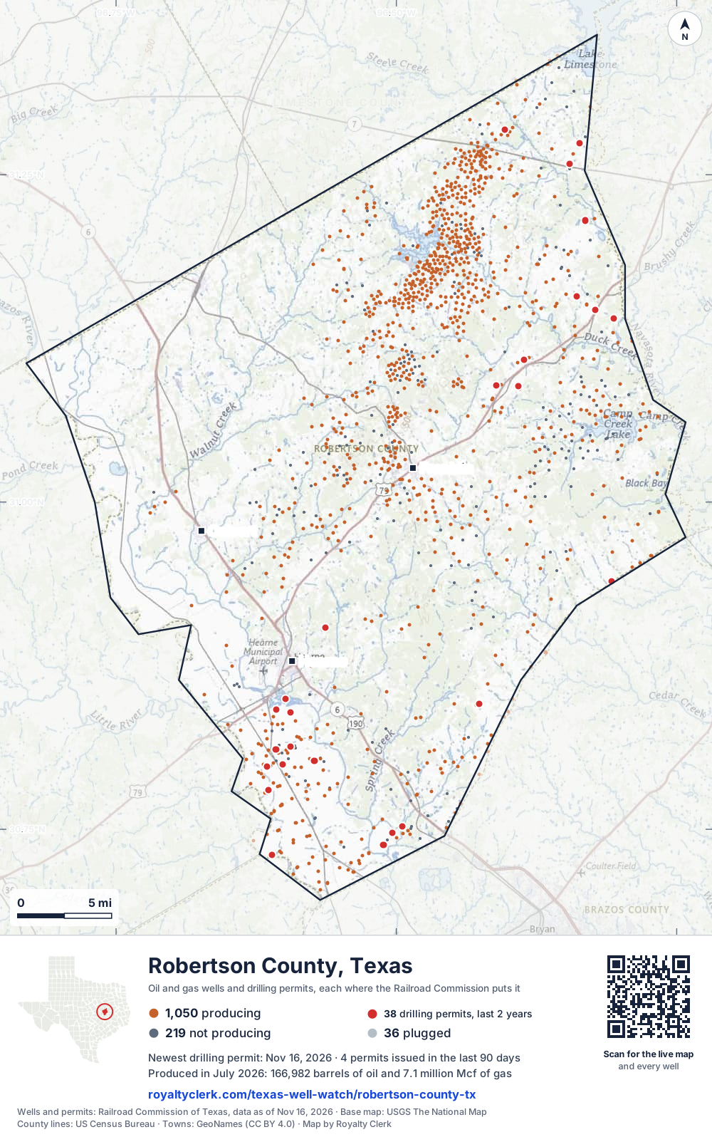
- Drilling locations37Permits issued in the last two years
- Producing wells1,050On a lease reporting production now
- Not producing219Shut in, inactive or no lease on record
- Plugged36The state's wellbore record says plugged
Sources: Railroad Commission of Texas well layers and permit files, US Census Bureau county outline, town points from GeoNames (CC BY 4.0), base map from USGS The National Map. A dot is a surface location; a horizontal well runs a mile or more from it.
1,305 wells with a location on the state's map and 37 drilling locations permitted in the last 24 months, each where the Railroad Commission puts it.
A permit is not a well.
Robertson County is one of the 27 counties of the Eagle Ford Shale
Wells near each town in Robertson County
Wells within 10 miles of each town, on either side of the county line.
Use this map on your site
You may show this map on any site, unchanged. Keep the credit line and its link to Royalty Clerk under the map. The picture updates by itself as the state records new wells and permits.
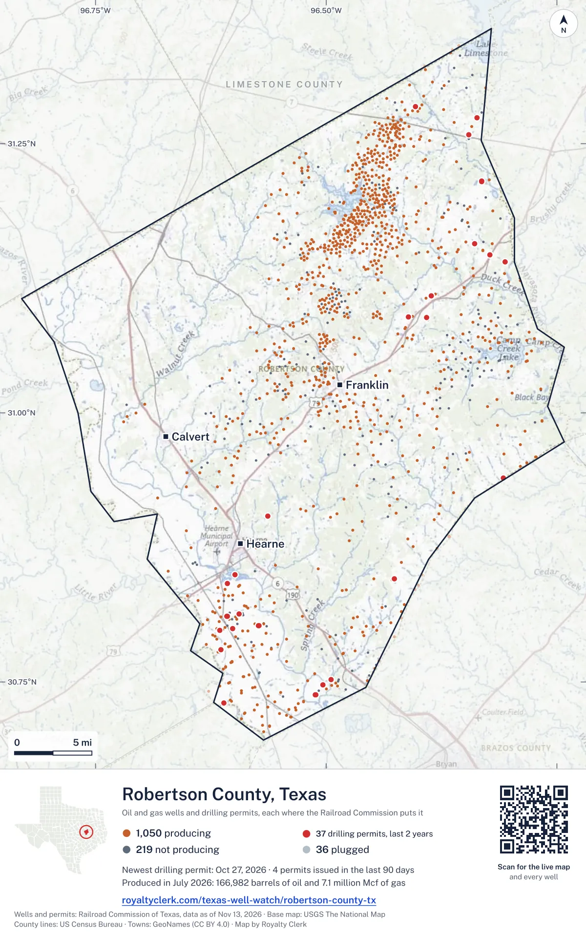
<a href="https://royaltyclerk.com/texas-well-watch/robertson-county-tx"><img src="https://royaltyclerk.com/maps/county-wells/robertson-county-tx.svg" alt="Map of Robertson County, Texas, with 1,305 oil and gas wells and 37 recent drilling locations as dots." width="1000" height="1596" loading="lazy" style="max-width:100%;height:auto;border:0"></a>
<p style="margin:4px 0 0;font-size:14px">Map: <a href="https://royaltyclerk.com/texas-well-watch/robertson-county-tx">Robertson County, Texas oil and gas wells</a> by Royalty Clerk, from Railroad Commission of Texas records</p>
The last twelve months
Month by month in Robertson County
| Month | Permits | Completions | First production |
|---|---|---|---|
| Oct 2026 | 1 | 1 | 0 |
| Sep 2026 | 0 | 1 | 0 |
| Aug 2026 | 5 | 1 | 0 |
| Jul 2026 | 0 | 2 | 0 |
| Jun 2026 | 5 | 1 | 1 |
| May 2026 | 1 | 1 | 0 |
| Apr 2026 | 6 | 1 | 0 |
| Mar 2026 | 3 | 1 | 1 |
| Jan 2026 | 0 | 1 | 0 |
| Dec 2025 | 1 | 1 | 0 |
Counted from November 15, 2025 to October 27, 2026, so the first and last months are partial. Source: Railroad Commission of Texas data sets.
Free, no sign-in
The newest drilling permits in Robertson County
| Issued | Lease and well | Operator | Drilling began | Depth, ft | API number | Coordinates | Permit |
|---|---|---|---|---|---|---|---|
| 2026-10-27 | B RIDGE SWD 1new drill · verticalBrahma Services II LLCAPI 42-395-32141 · permit 091960031.14669, -96.322898,000 ft | Brahma Services II LLC | |||||
| 2026-08-28 | KADAV 2Hnew drill · horizontalCML Exploration, LLCAPI 42-395-32140 · permit 091807430.93967, -96.308197,500 ft | CML Exploration, LLC | |||||
| 2026-08-27 | GREAT EAGLE AC TWO H 02GEnew drill · horizontalMagnolia Oil & Gas Operating LLCAPI 42-395-32138 · permit 091795830.77981, -96.614177,000 ft | Magnolia Oil & Gas Operating LLC | |||||
| 2026-08-21 | WHEELER ECW 1Hnew drill · horizontalComstock Oil & Gas, LLCAPI 42-395-32139 · permit 091797831.25822, -96.3457130,000 ft | Comstock Oil & Gas, LLC | |||||
| 2026-08-14 | GREAT EAGLE AC FOUR H 04GEnew drill · horizontalMagnolia Oil & Gas Operating LLCAPI 42-395-32137 · permit 091779530.77983, -96.614117,000 ft | Magnolia Oil & Gas Operating LLC | |||||
| 2026-08-10 | BUCHANAN SWD 2recompletion · verticalHilcorp Energy CompanyAPI 42-395-30812 · permit 091769831.28424, -96.4034313,278 ft | Hilcorp Energy Company | |||||
| 2026-06-30 | LIGHTSEY D 1HAnew drill · horizontalWildfire Energy Operating LLCAPI 42-395-32134 · permit 091603630.73822, -96.511058,000 ft | Wildfire Energy Operating LLC | |||||
| 2026-06-15 | FLOWERS-REISTINO UNIT B 5HAnew drill · horizontalWildfire Energy Operating LLCAPI 42-395-32136 · permit 091622630.73038, -96.61101drilling began 2026-07-09 · 7,000 ft | Wildfire Energy Operating LLC | |||||
| 2026-06-15 | FLOWERS-REISTINO UNIT A 2HAnew drill · horizontalWildfire Energy Operating LLCAPI 42-395-32135 · permit 091620230.73041, -96.61092drilling began 2026-07-08 · 7,000 ft | Wildfire Energy Operating LLC | |||||
| 2026-06-03 | CAMP B 6HBnew drill · horizontalAdamas Energy LLCAPI 42-395-32133 · permit 091603331.21505, -96.33131drilling began 2026-08-12 · 15,400 ft | Adamas Energy LLC | |||||
| 2026-06-03 | CAMP A 4HBnew drill · horizontalAdamas Energy LLCAPI 42-395-32132 · permit 091603231.21510, -96.33135drilling began 2026-08-09 · 15,400 ft | Adamas Energy LLC | |||||
| 2026-05-11 | ALFORD CHR 1Hnew drill · horizontalComstock Oil & Gas, LLCAPI 42-395-32131 · permit 091541331.27394, -96.33683drilling began 2026-08-16 · 30,000 ft | Comstock Oil & Gas, LLC | |||||
| 2026-04-23 | HADRIAN UNIT 1Hnew drill · horizontalBull Run Resources, LLCAPI 42-395-32130 · permit 091502030.84600, -96.425849,000 ft | Bull Run Resources, LLC | |||||
| 2026-04-22 | CIRCLE M ALLOC C 3Hnew drill · horizontalComstock Oil & Gas, LLCAPI 42-395-32129 · permit 091492031.10842, -96.38608drilling began 2026-06-08 · 30,000 ft | Comstock Oil & Gas, LLC | |||||
| 2026-04-22 | CIRCLE M ALLOC B 2Hnew drill · horizontalComstock Oil & Gas, LLCAPI 42-395-32128 · permit 091491931.10847, -96.38612drilling began 2026-06-10 · 30,000 ft | Comstock Oil & Gas, LLC | |||||
| 2026-04-08 | PREAKNESS STAKES 2HEnew drill · horizontalMagnolia Oil & Gas Operating LLCAPI 42-395-32127 · permit 091446930.84136, -96.60704drilling began 2026-04-23 · 7,000 ft | Magnolia Oil & Gas Operating LLC | |||||
| 2026-04-08 | BELMONT STUD 4HAnew drill · horizontalMagnolia Oil & Gas Operating LLCAPI 42-395-32126 · permit 091446830.84131, -96.60701drilling began 2026-04-22 · 6,500 ft | Magnolia Oil & Gas Operating LLC | |||||
| 2026-04-02 | ARKENSTONE A 1HAnew drill · horizontalWildfire Energy Operating LLCAPI 42-395-32124 · permit 091427430.80228, -96.57319drilling began 2026-08-20 · 7,000 ft | Wildfire Energy Operating LLC | |||||
| 2026-03-27 | ARKENSTONE B 2HAnew drill · horizontalWildfire Energy Operating LLCAPI 42-395-32125 · permit 091431630.80232, -96.57311drilling began 2026-08-20 · 7,000 ft | Wildfire Energy Operating LLC | |||||
| 2026-03-06 | BEORN B 2HAnew drill · horizontalWildfire Energy Operating LLCAPI 42-395-32098 · permit 091377630.81301, -96.594557,000 ft | Wildfire Energy Operating LLC | |||||
| 2026-03-04 | BEORN A 1HAnew drill · horizontalWildfire Energy Operating LLCAPI 42-395-32097 · permit 091377530.81294, -96.594507,000 ft | Wildfire Energy Operating LLC | |||||
| 2025-12-09 | DEPOT 1new drill · verticalMagnetar Operating LLCAPI 42-395-32123 · permit 091199430.79933, -96.6011217,000 ft | Magnetar Operating LLC | |||||
| 2025-10-30 | COLLIN 1HBnew drill · horizontalAdamas Energy LLCAPI 42-395-32121 · permit 091146231.15683, -96.33933drilling began 2026-03-29 · 15,600 ft | Adamas Energy LLC | |||||
| 2025-10-16 | HONEY 1new drill · verticalMagnetar Operating LLCAPI 42-395-32120 · permit 091107131.08902, -96.41078drilling began 2025-11-24 · 16,800 ft | Magnetar Operating LLC | |||||
| 2025-08-19 | BEATRICE 1new drill · verticalMagnetar Operating LLCAPI 42-395-32119 · permit 090993730.90398, -96.56322drilling began 2025-09-30 · 16,500 ft | Magnetar Operating LLC | |||||
| 2025-08-11 | ERS GAS UNIT 2HBnew drill · horizontalAethon Energy Operating LLCAPI 42-395-32118 · permit 090975431.08847, -96.3910416,500 ft | Aethon Energy Operating LLC | |||||
| 2025-08-04 | ERS GAS UNIT 1Hnew drill · horizontalAdamas Energy LLCAPI 42-395-32117 · permit 090962731.08843, -96.39111drilling began 2025-12-19 · 16,500 ft | Adamas Energy LLC | |||||
| 2025-07-17 | DIAMOND TRIO RANCH 001new drill · verticalMagnetar Operating LLCAPI 42-395-32116 · permit 090926030.84952, -96.59901drilling began 2025-08-04 · 16,500 ft | Magnetar Operating LLC | |||||
| 2025-03-21 | MCCULLOUGH GLR C 3Hnew drill · horizontalComstock Oil & Gas, LLCAPI 42-395-32115 · permit 090665931.14036, -96.30580drilling began 2025-04-13 · 25,000 ft | Comstock Oil & Gas, LLC | |||||
| 2025-01-07 | ARAGORN B 2Hnew drill · horizontalWildfire Energy Operating LLCAPI 42-395-32114 · permit 090496630.81092, -96.60742drilling began 2025-07-28 · 7,500 ft | Wildfire Energy Operating LLC | |||||
| 2024-12-20 | ARAGORN A 1Hnew drill · horizontalWildfire Energy Operating LLCAPI 42-395-32113 · permit 090482430.81099, -96.60748drilling began 2025-07-29 · 7,500 ft | Wildfire Energy Operating LLC | |||||
| 2024-12-16 | COTROPIA-FERRARA UNIT 5new drill · horizontalWildfire Energy Operating LLCAPI 42-395-32112 · permit 090467930.79796, -96.61548drilling began 2025-07-15 · 7,500 ft | Wildfire Energy Operating LLC | |||||
| 2024-12-11 | ECLIPSE 1HEnew drill · horizontalWildfire Energy Operating LLCAPI 42-395-32111 · permit 090456030.75203, -96.49475drilling began 2025-02-15 · 8,500 ft | Wildfire Energy Operating LLC | |||||
| 2024-11-25 | ASTEROID 1HEnew drill · horizontalWildfire Energy Operating LLCAPI 42-395-32110 · permit 090423230.75199, -96.49482drilling began 2025-02-14 · 8,500 ft | Wildfire Energy Operating LLC | |||||
| 2024-11-25 | MILKY WAY 1HEnew drill · horizontalWildfire Energy Operating LLCAPI 42-395-32109 · permit 090423130.74721, -96.50339drilling began 2025-01-31 · 8,500 ft | Wildfire Energy Operating LLC | |||||
| 2024-11-25 | LIGHTSEY C 5HEnew drill · horizontalWildfire Energy Operating LLCAPI 42-395-32108 · permit 090422930.73796, -96.51155drilling began 2025-01-04 · 8,500 ft | Wildfire Energy Operating LLC | |||||
| 2024-11-25 | LIGHTSEY B 3HEnew drill · horizontalWildfire Energy Operating LLCAPI 42-395-32107 · permit 090422630.73791, -96.51163drilling began 2025-01-03 · 8,500 ft | Wildfire Energy Operating LLC | |||||
| 2024-11-12 | MABLE MCCULLOUGH 3new drill · horizontalComstock Oil & Gas, LLCAPI 42-395-32106 · permit 090386531.14032, -96.30577drilling began 2025-01-17 · 14,640 ft | Comstock Oil & Gas, LLC | |||||
| 2024-11-12 | MCCULLOUGH GLR A 1Hnew drill · horizontalComstock Oil & Gas, LLCAPI 42-395-32105 · permit 090386431.14027, -96.30574drilling began 2025-01-19 · 25,000 ft | Comstock Oil & Gas, LLC | |||||
| 2024-10-24 | MOSS GAS UNIT 1recompletion · verticalHilcorp Energy CompanyAPI 42-395-31188 · permit 090348730.85302, -96.6711914,500 ft | Hilcorp Energy Company | |||||
| 2024-08-29 | CAMP 3HBnew drill · horizontalAethon Energy Operating LLCAPI 42-395-32104 · permit 090236531.21668, -96.32341drilling began 2024-09-26 · 15,530 ft | Aethon Energy Operating LLC | |||||
| 2024-08-22 | GREAT BALLS OF FIRE 1STrecompletion · horizontalBBL Operating Company LLCAPI 42-395-32010 · permit 090212230.79213, -96.49600drilling began 2025-06-19 · 9,000 ft | BBL Operating Company LLC | |||||
| 2024-07-26 | RING A 1HAnew drill · horizontalWildfire Energy Operating LLCAPI 42-395-32103 · permit 090150730.79783, -96.61539drilling began 2024-08-29 · 7,500 ft | Wildfire Energy Operating LLC | |||||
| 2024-07-12 | PERRY GAS UNIT 2recompletion · verticalHilcorp Energy CompanyAPI 42-395-31658 · permit 090104730.99984, -96.6248112,650 ft | Hilcorp Energy Company | |||||
| 2024-05-01 | HOLMES B UNIT 1HBnew drill · horizontalAethon Energy Operating LLCAPI 42-395-32102 · permit 089935331.14766, -96.4024315,500 ft | Aethon Energy Operating LLC | |||||
| 2024-05-01 | HOLMES A UNIT 1HBnew drill · horizontalAethon Energy Operating LLCAPI 42-395-32101 · permit 089934931.14772, -96.4024715,500 ft | Aethon Energy Operating LLC | |||||
| 2024-04-15 | CAMP 1HBnew drill · horizontalAethon Energy Operating LLCAPI 42-395-32099 · permit 089810431.21661, -96.3234015,150 ft | Aethon Energy Operating LLC | |||||
| 2024-03-14 | CAMP 2HBnew drill · horizontalAethon Energy Operating LLCAPI 42-395-32100 · permit 089810531.21661, -96.32340drilling began 2024-09-02 · 15,530 ft | Aethon Energy Operating LLC | |||||
| 2024-02-21 | BEORN B 2HAnew drill · horizontalWildfire Energy Operating LLCAPI 42-395-32098 · permit 089738730.81301, -96.59455drilling began 2026-07-21 · 7,000 ft | Wildfire Energy Operating LLC | |||||
| 2024-02-21 | BEORN A 1HAnew drill · horizontalWildfire Energy Operating LLCAPI 42-395-32097 · permit 089738530.81294, -96.59450drilling began 2026-07-21 · 7,000 ft | Wildfire Energy Operating LLC |
These are the newest 50 of 54 permits on file for Robertson County. The rest follow, 50 to a page.
A permit is permission to drill, not a well. Source: Railroad Commission of Texas drilling permit files.
Year by year
Drilling permits issued in Robertson County, by year
| Year | Permits issued |
|---|---|
| 2026 so far | 21 |
| 2025 | 9 |
| 2024 | 20 |
| 2023 | 4 |
Counted from the permit files we hold, which start in 2023; that first year may be partial. Source: Railroad Commission of Texas drilling permit files.
The latest
The most recent records
| Date | What, who and where |
|---|---|
| 2026-10-27 | Permit issued: Brahma Services II LLCB RIDGE SWD · A-298 · permit 0919600 |
| 2026-10-07 | Completed: Wildfire Energy Operating LLCLIGHTSEY D · A-95 · permit 0916036 |
| 2026-09-13 | Completed: Wildfire Energy Operating LLCARKENSTONE A · A-31 · permit 0914274 |
| 2026-08-28 | Permit issued: CML Exploration, LLCKADAV · A-39 · permit 0918074 |
| 2026-08-27 | Permit issued: Magnolia Oil & Gas Operating LLCGREAT EAGLE AC TWO · A-31 · permit 0917958 |
| 2026-08-21 | Permit issued: Comstock Oil & Gas, LLCWHEELER ECW · A-25 · permit 0917978 |
| 2026-08-14 | Permit issued: Magnolia Oil & Gas Operating LLCGREAT EAGLE AC FOUR · A-31 · permit 0917795 |
| 2026-08-10 | Permit issued: Hilcorp Energy CompanyBUCHANAN SWD · A-231 · permit 0917698 |
| 2026-08-09 | Completed: Wildfire Energy Operating LLCFLOWERS-REISTINO UNIT B · A-31 · permit 0916226 |
| 2026-07-28 | Completed: Wildfire Energy Operating LLCFLOWERS-REISTINO UNIT A · A-31 · permit 0916202 |
| 2026-07-18 | CompletedA-231 |
| 2026-06-30 | Permit issued: Wildfire Energy Operating LLCLIGHTSEY D · A-95 · permit 0916036 |
| 2026-06-15 | Completed: Adamas Energy LLCCOLLIN · A-176 · permit 0911462 |
| 2026-06-15 | Permit issued: Wildfire Energy Operating LLCFLOWERS-REISTINO UNIT B · A-31 · permit 0916226 |
| 2026-06-15 | Permit issued: Wildfire Energy Operating LLCFLOWERS-REISTINO UNIT A · A-31 · permit 0916202 |
Follow it
Watch Robertson County, or one abstract
What do you want to follow?
Where the land is. Your deed or lease names it.
For example A-1119, or Bush, or T&P 38. Your deed or the tax bill has it.
Other counties
Drilling activity in other counties
Related
Related
- ToolTexas well watchPermit, completion, first production and when the first check is due.
- ToolIs this buyout offer fair?The offer as months of your income, what the acres mean, and the questions to ask.
- ToolIs this lease offer good?Bonus and royalty against the county, and a scan of the lease's clauses.
- Texas dataTexas operator changesWho took over whose leases in the last 24 months.
- ToolLate payment interestDeadlines and the interest a late payment earns.
- Texas dataTexas oil and gas atlas254 counties, every lease, operator and field.
FAQ
Questions people ask
How many wells were permitted in Robertson County in the last year?
The Railroad Commission issued 22 drilling permits in Robertson County in the twelve months to October 27, 2026, and recorded 11 completions and 2 first-production reports. A permit is permission to drill, not a well.
How do I get an alert when a permit is issued near my land in Robertson County?
Choose your abstract on this page, or the whole county, and sign in. You get one email a week, only when something new is recorded after you sign up. The alert says whether an event is on an interest in your Mineral File, on a place you follow, or only nearby.
When is my first royalty check due after a new well?
Natural Resources Code section 91.402(a) says on or before 120 days after the end of the month of first sale of production from the well. The state's first-production month is the closest public marker, so the date on this page is the earliest, not a certainty.
Got a new well on your land?
The first check is due within 120 days after the end of the month of first sale.
Sources
Primary sources, opened on 29 September 2026. Statute text is the current version on statutes.capitol.texas.gov.