
Robertson County, Texas
Oil wells and drilling locations near Hearne
- 304wells
- 16drilling locations in two years
- 204producing leases
Within 10 miles
Wells and drilling locations around Hearne
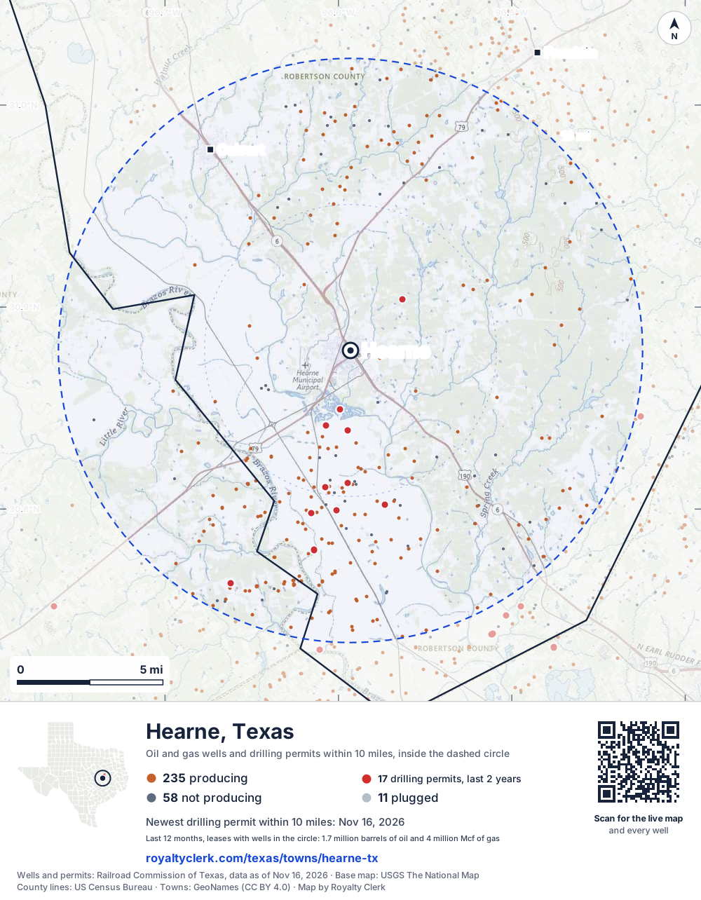
- Drilling locations16Permits issued in the last two years
- Producing wells235On a lease reporting production now
- Not producing58Shut in, inactive or no lease on record
- Plugged11The state's wellbore record says plugged
The dashed circle is 10 miles from the town's point (30.87852, -96.59303); the counts are for wells inside it. Sources: Railroad Commission of Texas well layers and permit files, US Census Bureau county outlines, town points from GeoNames (CC BY 4.0), base map from USGS The National Map.
Use this map on your site
You may show this map on any site, unchanged. Keep the credit line and its link to Royalty Clerk under the map. The picture updates by itself as the state records new wells and permits.
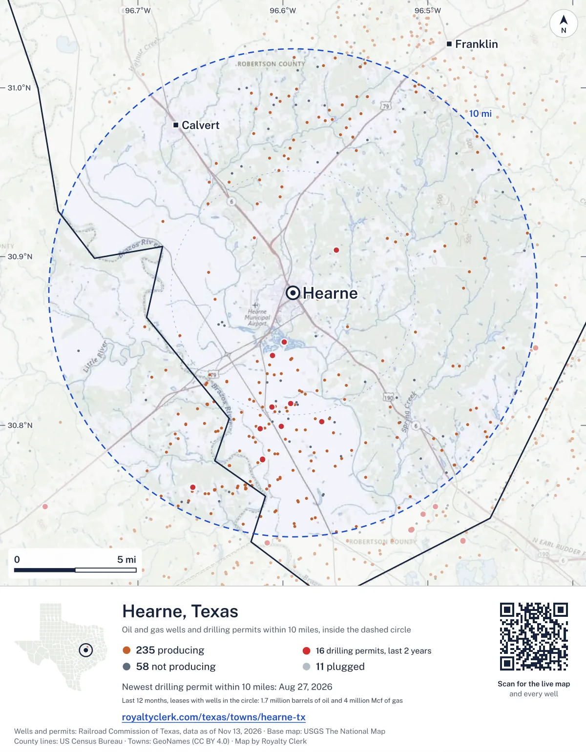
<a href="https://royaltyclerk.com/texas/towns/hearne-tx"><img src="https://royaltyclerk.com/maps/town-wells/hearne-tx.svg" alt="Map of Hearne, Texas: 304 wells and 16 recent drilling locations within 10 miles, inside a dashed circle." width="1000" height="1284" loading="lazy" style="max-width:100%;height:auto;border:0"></a>
<p style="margin:4px 0 0;font-size:14px">Map: <a href="https://royaltyclerk.com/texas/towns/hearne-tx">Hearne, Texas oil and gas wells</a> by Royalty Clerk, from Railroad Commission of Texas records</p>
Which way it is heading
Where the new drilling is around Hearne
What became of the 16 permits
- 5finished, on a lease that reports productionThe well was completed and its lease is reporting oil or gas to the state.
- 6drilling startedThe operator reported a start date. No completion is on file yet.
- 5still only a permitNothing after the permit is on file. Many permits wait a year or more, and some are never drilled.
Wells finished in the last two years: 3 south, 2 south-west of town.
A horizontal well runs sideways underground. 66 wells start outside the 10-mile circle and end inside it. 31 start inside and end outside. So a well can drain land a mile or two from the spot where it shows on a map.
A permit is permission to drill, not a well, and a well nearby says nothing about who owns the minerals under it. Direction is taken from the well's surface location. Source: Railroad Commission of Texas drilling permits and wellbore records.
In numbers
Oil and gas within 10 miles of Hearne
- wells with a location on the state's map
- 304
- drilling permits in the last 24 months
- 16
- producing leases with a well in the circle
- 204
- operators running them
- 9
- oil and condensate those leases reported in their latest 12 months
- 1,731,524 bbl
- gas those leases reported in their latest 12 months
- 4,019,105 mcf
A lease counts when at least one of its wells is inside the circle; its whole production is counted, so a lease reaching beyond the circle counts in full.
In dollars
What the oil and gas near Hearne sold for
- sale value of 12 months, before taxes and costs
- $139 million
- oil and condensate sold
- 1,690,106 bbl
- gas sold
- 3,488,344 mcf
- the middle lease: half sold more, half less
- $170,467
A 0.01 share (1%) of the middle producing lease near Hearne comes to about $1,705 for the 12 months.
Sold volumes at the public monthly prices, before severance tax and any costs. A guide to the size, not what any owner was paid.
Sold volumes from each lease's monthly report to the Railroad Commission, times the month's West Texas Intermediate oil price and Henry Hub gas price (EIA). Real prices at the lease differ. A lease counts in full when one of its wells is near the town. Check a statement against what the lease sold
Drilling locations
The newest drilling permits near Hearne
| Issued | Lease and well | Where | Operator |
|---|---|---|---|
| 2026-08-27 | GREAT EAGLE AC TWO H 02GEhorizontal · API 42-395-32138 · permit 0917958Magnolia Oil & Gas Operating LLC | 6.9 mi S30.77981, -96.61417 on OpenStreetMap (opens in a new tab) | Magnolia Oil & Gas Operating LLC |
| 2026-08-14 | GREAT EAGLE AC FOUR H 04GEhorizontal · API 42-395-32137 · permit 0917795Magnolia Oil & Gas Operating LLC | 6.9 mi S30.77983, -96.61411 on OpenStreetMap (opens in a new tab) | Magnolia Oil & Gas Operating LLC |
| 2026-04-08 | PREAKNESS STAKES 2HEhorizontal · API 42-395-32127 · permit 0914469Magnolia Oil & Gas Operating LLC | 2.7 mi S30.84136, -96.60704 on OpenStreetMap (opens in a new tab) | Magnolia Oil & Gas Operating LLC |
| 2026-04-08 | BELMONT STUD 4HAhorizontal · API 42-395-32126 · permit 0914468Magnolia Oil & Gas Operating LLC | 2.7 mi S30.84131, -96.60701 on OpenStreetMap (opens in a new tab) | Magnolia Oil & Gas Operating LLC |
| 2026-04-02 | ARKENSTONE A 1HAhorizontal · API 42-395-32124 · permit 0914274Wildfire Energy Operating LLC | 5.4 mi S30.80228, -96.57319 on OpenStreetMap (opens in a new tab) | Wildfire Energy Operating LLC |
| 2026-03-27 | ARKENSTONE B 2HAhorizontal · API 42-395-32125 · permit 0914316Wildfire Energy Operating LLC | 5.4 mi S30.80232, -96.57311 on OpenStreetMap (opens in a new tab) | Wildfire Energy Operating LLC |
| 2026-03-06 | BEORN B 2HAhorizontal · API 42-395-32098 · permit 0913776Wildfire Energy Operating LLC | 4.5 mi S30.81301, -96.59455 on OpenStreetMap (opens in a new tab) | Wildfire Energy Operating LLC |
| 2026-03-04 | BEORN A 1HAhorizontal · API 42-395-32097 · permit 0913775Wildfire Energy Operating LLC | 4.5 mi S30.81294, -96.59450 on OpenStreetMap (opens in a new tab) | Wildfire Energy Operating LLC |
| 2025-12-09 | DEPOT 1vertical · API 42-395-32123 · permit 0911994Magnetar Operating LLC | 5.5 mi S30.79933, -96.60112 on OpenStreetMap (opens in a new tab) | Magnetar Operating LLC |
| 2025-09-02 | TRACK PHAROAH 4HAhorizontal · API 42-331-35133 · permit 0910145Magnolia Oil & Gas Operating LLC | 8.9 mi SW30.76331, -96.66219 on OpenStreetMap (opens in a new tab) | Magnolia Oil & Gas Operating LLC |
| 2025-09-02 | TRACK JUSTIFY 2HEhorizontal · API 42-331-35132 · permit 0910144Magnolia Oil & Gas Operating LLC | 8.9 mi SW30.76330, -96.66225 on OpenStreetMap (opens in a new tab) | Magnolia Oil & Gas Operating LLC |
| 2025-08-19 | BEATRICE 1vertical · API 42-395-32119 · permit 0909937Magnetar Operating LLC | 2.5 mi NE30.90398, -96.56322 on OpenStreetMap (opens in a new tab) | Magnetar Operating LLC |
| 2025-07-17 | DIAMOND TRIO RANCH 001vertical · API 42-395-32116 · permit 0909260Magnetar Operating LLC | 2.0 mi S30.84952, -96.59901 on OpenStreetMap (opens in a new tab) | Magnetar Operating LLC |
| 2025-01-07 | ARAGORN B 2Hhorizontal · API 42-395-32114 · permit 0904966Wildfire Energy Operating LLC | 4.7 mi S30.81092, -96.60742 on OpenStreetMap (opens in a new tab) | Wildfire Energy Operating LLC |
| 2024-12-20 | ARAGORN A 1Hhorizontal · API 42-395-32113 · permit 0904824Wildfire Energy Operating LLC | 4.7 mi S30.81099, -96.60748 on OpenStreetMap (opens in a new tab) | Wildfire Energy Operating LLC |
| 2024-12-16 | COTROPIA-FERRARA UNIT 5horizontal · API 42-395-32112 · permit 0904679Wildfire Energy Operating LLC | 5.7 mi S30.79796, -96.61548 on OpenStreetMap (opens in a new tab) | Wildfire Energy Operating LLC |
| 2024-10-24 | MOSS GAS UNIT 1vertical · API 42-395-31188 · permit 0903487Hilcorp Energy Company | 5.0 mi W30.85302, -96.67119 on OpenStreetMap (opens in a new tab) | Hilcorp Energy Company |
| 2024-08-27 | CADDO A 1Hhorizontal · API 42-331-33509 · permit 0902218Magnolia Oil & Gas Operating LLC | 9.9 mi SW30.75214, -96.67220 on OpenStreetMap (opens in a new tab) | Magnolia Oil & Gas Operating LLC |
| 2024-08-22 | GREAT BALLS OF FIRE 1SThorizontal · API 42-395-32010 · permit 0902122BBL Operating Company LLC | 8.3 mi SE30.79213, -96.49600 on OpenStreetMap (opens in a new tab) | BBL Operating Company LLC |
| 2024-07-26 | RING A 1HAhorizontal · API 42-395-32103 · permit 0901507Wildfire Energy Operating LLC | 5.7 mi S30.79783, -96.61539 on OpenStreetMap (opens in a new tab) | Wildfire Energy Operating LLC |
| 2024-07-12 | PERRY GAS UNIT 2vertical · API 42-395-31658 · permit 0901047Hilcorp Energy Company | 8.6 mi N30.99984, -96.62481 on OpenStreetMap (opens in a new tab) | Hilcorp Energy Company |
| 2024-02-21 | BEORN B 2HAhorizontal · API 42-395-32098 · permit 0897387Wildfire Energy Operating LLC | 4.5 mi S30.81301, -96.59455 on OpenStreetMap (opens in a new tab) | Wildfire Energy Operating LLC |
| 2024-02-21 | BEORN A 1HAhorizontal · API 42-395-32097 · permit 0897385Wildfire Energy Operating LLC | 4.5 mi S30.81294, -96.59450 on OpenStreetMap (opens in a new tab) | Wildfire Energy Operating LLC |
| 2023-07-31 | LITTLE SISTER 1Hhorizontal · API 42-395-32093 · permit 0892272BBL Operating Company LLC | 6.8 mi SE30.78953, -96.54310 on OpenStreetMap (opens in a new tab) | BBL Operating Company LLC |
| 1999-12-02 | KYLE 1horizontal · API 42-331-33512 · permit 0485850Magnolia Oil & Gas Operating LLC | 9.1 mi SW30.76100, -96.66256 on OpenStreetMap (opens in a new tab) | Magnolia Oil & Gas Operating LLC |
A permit is permission to drill, not a well. Distances are from the town's point to the well's surface location. Source: Railroad Commission of Texas drilling permits.
Find your land
The surveys under the new drilling near Hearne
- A-31 NIXON, G A12 permits, newest August 27, 2026
- A-53 RODRIGUEZ, F2 permits, newest September 2, 2025
- A-226 MC NEEL, P S1 permit, newest August 19, 2025
- A-41 RUIZ, F1 permit, newest July 17, 2025
Not in the list? Search every survey in the county by name or abstract number.
Producing leases
Top producing leases near Hearne
- 1Aragorn A160,069 bbl · 69,739 mcf a yearWildfire Energy Operating LLC · Robertson County · 1 well in the circle
- 2Cotropia-Ferrara Unit131,613 bbl · 96,487 mcf a yearWildfire Energy Operating LLC · Robertson County · 5 wells in the circle
- 3Aragorn B130,055 bbl · 85,172 mcf a yearWildfire Energy Operating LLC · Robertson County · 1 well in the circle
- 4Ring A97,706 bbl · 52,242 mcf a yearWildfire Energy Operating LLC · Robertson County · 1 well in the circle
- 5Track Justify89,981 bbl · 19,584 mcf a yearMagnolia Oil & Gas Operating LLC · Milam County · 1 well in the circle
- 6T-Bar-X/Tullous0 bbl · 455,021 mcf a yearDiversified Production LLC · Robertson County · 1 well in the circle
- 7Flowers-Reistino Unit60,875 bbl · 64,798 mcf a yearWildfire Energy Operating LLC · Robertson County · 2 wells in the circle
- 8Wolf Unit33,916 bbl · 161,594 mcf a yearMagnolia Oil & Gas Operating LLC · Milam County · 3 wells in the circle
- 9Holden-Moore Unit29,318 bbl · 138,855 mcf a yearMagnolia Oil & Gas Operating LLC · Milam County · 3 wells in the circle
- 10Easy Rider48,742 bbl · 21,727 mcf a yearWildfire Energy Operating LLC · Burleson County · 1 well in the circle
- 11PMF34,692 bbl · 99,637 mcf a yearMagnolia Oil & Gas Operating LLC · Robertson County · 1 well in the circle
- 12Pale Rider36,435 bbl · 87,664 mcf a yearMagnolia Oil & Gas Operating LLC · Robertson County · 1 well in the circle
- 13Amelia Kay31,087 bbl · 113,601 mcf a yearMagnolia Oil & Gas Operating LLC · Milam County · 1 well in the circle
- 14Emerie33,519 bbl · 79,512 mcf a yearMagnolia Oil & Gas Operating LLC · Milam County · 1 well in the circle
- 15Pabst Unit29,225 bbl · 90,056 mcf a yearMagnolia Oil & Gas Operating LLC · Robertson County · 2 wells in the circle
- 16Scamardo Hcx2 Ac37,593 bbl · 30,581 mcf a yearWildfire Energy Operating LLC · Robertson County · 1 well in the circle
- 17Beverly Gale29,369 bbl · 56,413 mcf a yearMagnolia Oil & Gas Operating LLC · Robertson County · 1 well in the circle
- 18SVR 'B'36,513 bbl · 10,356 mcf a yearNorthfield Enterprises, Inc. · Robertson County · 3 wells in the circle
- 19Lauren23,977 bbl · 65,012 mcf a yearMagnolia Oil & Gas Operating LLC · Milam County · 1 well in the circle
- 20Scamardo-Cotropia Unit27,200 bbl · 20,015 mcf a yearWildfire Energy Operating LLC · Robertson County · 3 wells in the circle
Whose name is on the check
Who buys the oil and gas near Hearne
Oil and condensate
- ENERGY TRANS CRUDE MARKETING LLC156 leases
- SHELL TRADING (US) COMPANY72 leases
- 4J ENERGY, LLC55 leases
- EASTEX CRUDE COMPANY, LLC55 leases
- HARVEST MARKETING & TRADING, LLC21 leases
Gas
- ENERGY TRANSFER COMPANY97 leases
- XTO ENERGY INC.41 leases
- ET GATHERING & PROCESSING LLC34 leases
- TREND GATHERING & TREATING, LLC14 leases
- COMSTOCK OIL & GAS, LLC1 lease
From each lease's newest Form P-4 filing with the Railroad Commission, which names its gatherers and purchasers. One lease can name several.
If your checks stopped
Leases near Hearne that went quiet or changed hands
9 leases reported nothing for a year or more
Leases that reported within the last four years and then stopped. The newest to stop first.
- Spring Valley Ranch · Northfield Enterprises, Inc.last report November 2024
- Perry Gas Unit · Hilcorp Energy Companylast report July 2024
- Kudu Unit · LRR Pecos Valley, LLClast report September 2023
- Timberwolf Unit · LRR Pecos Valley, LLClast report September 2023
- Peter Gibson · Houston Gulf Energy Corporationlast report September 2023
- Cunningham Unit · LRR Pecos Valley, LLClast report August 2023
- Destefano, Catherine Unit · Wildfire Energy Operating LLClast report March 2023
- Margarita E Unit · Wildfire Energy Operating LLClast report March 2023
- Johnny B. Goode · BBL Operating Company LLClast report December 2022
From the monthly production reports operators file with the Railroad Commission. The newest months fill in late, so a lease is listed only after 12 months with no report.
Year by year
Production of the leases near Hearne, by year
| Year | Oil, bbl | Gas, mcf |
|---|---|---|
| 2026 so far | 1,066,919 | 2,661,469 |
| 2025 | 1,599,741 | 3,949,687 |
| 2024 | 1,762,608 | 4,553,102 |
| 2023 | 1,974,856 | 5,320,877 |
| 2022 | 2,639,899 | 6,171,675 |
| 2021 | 2,484,016 | 4,195,620 |
| 2020 | 2,260,841 | 4,448,658 |
Every lease with a well in the circle, producing now or not, as reported to the Railroad Commission. The newest months fill in as operators report.
The long view: in the state's records from September 1994 on, 239 of these leases reported 33,197,793 bbl of oil and condensate and 205,170,436 mcf of gas. Each lease page carries that lease's history back to January 1993.
Around it
Towns near Hearne
- Calvert8.4 mi NW130 wells · 2 permits
- Franklin12 mi NE548 wells · 6 permits
- Bryan19 mi SE660 wells · 17 permits
- Cameron23 mi W1,477 wells · 1 permits
- College Station23 mi SE522 wells · 4 permits
- Caldwell25 mi S1,046 wells · 24 permits
- Rosebud27 mi NW19 wells · 1 permits
- Hilltop Lakes27 mi NE235 wells · 12 permits
- Rockdale29 mi SW2,160 wells · 0 permits
Hearne is in ZIP code 77859: its wells and permits
All of Robertson County: leases, operators and production · Robertson County well map
Press and community kit
Writing about Hearne? Take what you need
Three facts to quote
- 304 oil and gas wells on the state's map lie within 10 miles of Hearne: 235 on producing leases, 58 not producing and 11 plugged.
- The Railroad Commission of Texas issued 9 drilling permits within 10 miles of Hearne in the last 12 months, the newest dated August 27, 2026.
- The 204 producing leases with a well in that circle, run by 9 operators, reported 1,731,524 barrels of oil and 4,019,105 thousand cubic feet of gas over their latest 12 months.
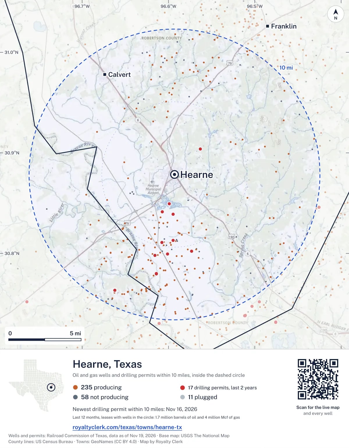
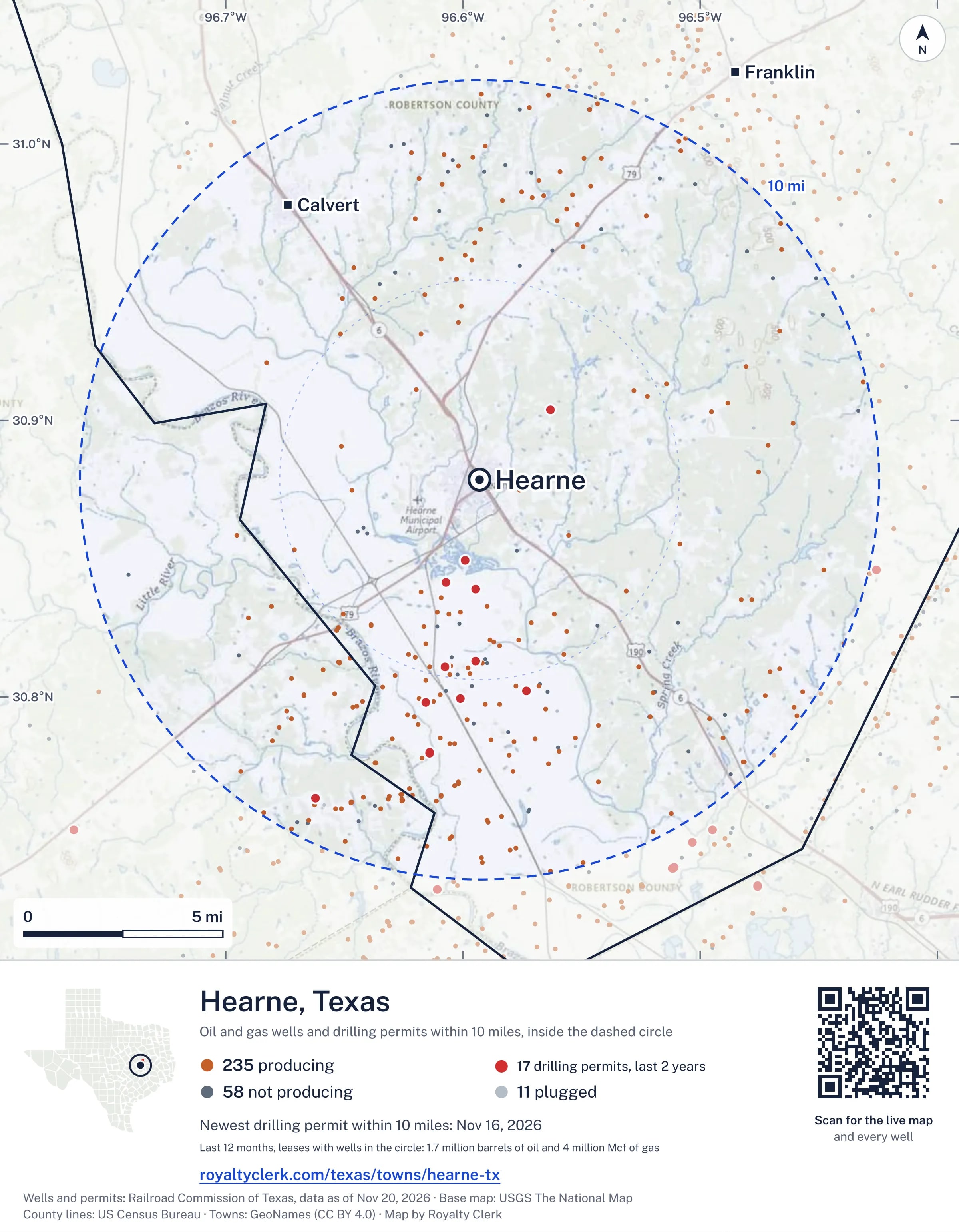
The map picture
The page's map with its legend and credit, as a JPEG.
The live map on your page
A frame that loads its picture first and the live map on a tap. No cookies.
How to cite
Railroad Commission of Texas records of the wells and drilling permits within 10 miles of Hearne, mapped by Royalty Clerk (https://royaltyclerk.com/texas/towns/hearne-tx), data as of November 15, 2026.
Under a map or a chart: Source: Railroad Commission of Texas · Map: Royalty Clerk, with a link to this page.
The figures say where the state's records put wells and permits, not who owns the land or the minerals. Kits for other Texas towns
Follow it
Watch the 10 miles around Hearne
Watching a place says nothing about who owns the land or the minerals there. For the whole county, or one survey, use the Robertson County well watch.
FAQ
Questions people ask
How many oil and gas wells are near Hearne?
304 wells with a location on the Railroad Commission's map lie within 10 miles of Hearne: 235 on leases that are producing, 58 not producing and 11 plugged. The state also issued 16 drilling permits with a well location in that circle in the last 24 months.
What are the coordinates on this page?
Latitude and longitude of the well's surface location in NAD83, the coordinates map apps use. They come from the Railroad Commission's well layers as published, and from its drilling permit files, which are published in the older NAD27 and converted here. Paste them into any map app. A horizontal well's bottom hole can be a mile or two away from its surface location.
Do I own minerals under a well near Hearne?
A well nearby says nothing about who owns the minerals under it. The county's mineral roll lists who is paid on each producing lease. Search a name to see whether the Robertson County roll lists it.
Is drilling near Hearne picking up or slowing down?
Drilling permits near Hearne are rising: 9 permits in the last 12 months, 7 in the 12 months before. Most of them are south of town: 15 of 16 lie on that side. The nearest is 2.0 miles south of the town's point. A permit is permission to drill, not a well.
How much are the oil and gas near Hearne worth?
The 204 producing leases with a well within 10 miles sold about $139 million of oil and gas in their newest 12 months on file, at the public monthly prices and before taxes and costs. That is what the leases sold, not what a tract of land or a mineral interest is worth: an owner is paid a share of one lease.
My checks from a lease here stopped. Why?
The usual reasons: the lease stopped producing, a new operator took it over, or the operator put the payments in suspense over a title or address question. Near Hearne, 9 leases went quiet and 0 changed operator; both lists are on this page.
Own land or minerals near Hearne?
See whether a county roll lists your name, and get an email when a permit or a new well is filed near you.
Sources
Primary sources, opened on 29 September 2026. Statute text is the current version on statutes.capitol.texas.gov.