
Texas countyRailroad Commission district 7BThrough July 2026
Shackelford CountyTexas oil and gas
Shackelford County sold 240,914 barrels of oil and 824 million cubic feet of gas in the last 12 months.
August 2026 is still coming in. About 89% of Texas leases have reported it so far, so this page counts through July 2026 until it is fully reported.
- Oil, last 12 months
- 240,914 bbl
- Gas, last 12 months
- 824 million cu ft
- Producing leases
- 326 of 830
- Wells on the map
- 3,190
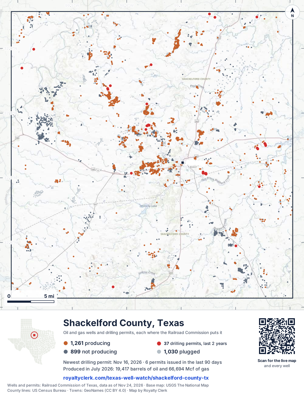
- Drilling locations, two years
- 36
- Wells on record
- 3,255
- Operators
- 69
- Top field
- Shackelford County Regular
The story, from 403 months of reports
When Petex took the lead from Van Operating in 2021
- 1Oil county JANUARY 1993
- 2Most new wells JUNE 2008
Petex took the lead in Shackelford County in 2021, after Van Operating had led it since 1995. Oil has made more of the county's output than gas in every full calendar year from 1993 to 2025. Oil in the last 12 months is a little under a fifth of 1994, the biggest full calendar year for oil.
The county has fewer leases now. In 2025, 624 leases reported here, against 1,224 in 1995, the most of any full calendar year. Operators reporting dropped too: 99 in 2025, against 245 in 1993.
Operators filed 29 permits in the last 12 months, against 14 in the 12 months before. Stasney Well Service, LLC filed 15 of them, and none are for horizontal wells.
- 1994 Oil output reached its biggest full calendar year, 1,519,418 barrels.
- 1995 Van Operating took 115 leases from Jones and became the leading operator.
- 1996 Gas output reached its biggest full calendar year, 6,734,457 mcf.
- 2017 Rover Petroleum took 32 leases from Merit Energy Company.
- 2021 Petex became the leading operator with 48 leases.
- 2024 Grayrock Energy II, LLC took 31 leases from Rover Petroleum Operating, LLC.
- 2026 Basin Operating Inc. reports 47 leases, its most of any year.
State records through July 2026.
Not a forecast, not reserves.
219 producing counties, biggest first
133rd in Texas for oil, 152nd for gas
Each line is one Texas county, drawn to what it sold in the last 12 months. Shackelford County is the blue one. In 1993 it was 89th for oil and 133rd for gas.
of all Texas oil in the last 12 months.
of all Texas gas.
operators. The biggest is Stasney Well Service, LLC.
fields. The biggest is Shackelford County Regular.
SourceTexas Railroad Commission Production Data Query, every county, August 2025 to July 2026.
For mineral owners, from the state record
What Shackelford County owners ask
- 01Who pays royalties in Shackelford County?
- Basin Operating Inc.37Petex34Stasney Well Service, LLC22
- 69 operators run the county's producing leases. The one that pays you is the company named on your check stub. Basin Operating Inc. runs the most leases, 37 of the 326.
- Source: Railroad Commission production reports, operator of record.
- Find the operator of your lease
- 02If oil or gas sold in July 2026, when would a regular check be due?
- Jul 31sale month endsSep 29oil dueOct 29gas due
- For a subsequent sale in July 2026, the usual Texas deadlines would be September 29, 2026 for oil and October 29, 2026 for gas. These are 60 and 90 days after month-end when the written agreement sets no payment schedule. First sales follow a different rule.
- Source: Railroad Commission production reports; Texas Natural Resources Code §91.402.
- See your next three checks
- 03Is my family's name on the Shackelford County mineral roll?
- Royalty interests4,418In an estate's name77
- The appraisal district's 2026 roll lists 4,418 royalty-interest records. At least 77 of them (1.74%) are still in the name of an estate. Search a family name to see whether an account is there.
- Source: Shackelford County Appraisal District, 2026 mineral roll. No owner is named on this page.
- Search a family name
- 04Why did my Shackelford County check go down?
- Oil sold▼ 8.74%Oil price▲ 6.53%Gas sold▼ 7.72%Gas price▲ 17.5%
- Across the county, oil sold is down 8.74% on the 12 months before and the oil price is up 6.53%. In the same months gas sold is down 7.72% and the gas price up 17.5%. A check can move with the county's volume and the price with nothing wrong on the lease. The statement check tells the two apart.
- Source: Railroad Commission production reports; U.S. Energy Information Administration prices.
- Why is my check lower?
- 05Who runs the leases here now?
- Petex is the leading operator, with 54 leases in 2026 so far. Through July 2026, 94 operators filed reports here. Stasney Well Service, LLC has 33 leases now, and Basin Operating Inc. has 47 leases.
- 06When did Van Operating stop reporting here?
- Van Operating, Ltd. led the county from 1995 to 2020. Its last year of reports here is 2022, and it reports no leases now. Its most leases were 137, in 1997.
- 07How does the county's output compare with its biggest years?
- Oil in the last 12 months (240,914 barrels) is a little under a fifth of 1994, its biggest full calendar year for oil: 15.9%. Gas in the last 12 months is a little over a tenth of 1996, its biggest full calendar year for gas: 12.2%.
- 08Who is filing the new drilling permits here?
- 9 operators filed 29 drilling permits in the last 12 months. Stasney Well Service, LLC filed 15 of them, Oaktree Oil Company filed 3, and Bluff Creek Petroleum, LLC filed 2. None are for horizontal wells.
- Find the land on my deed
- 09How many tax accounts does the county roll list?
- The county roll lists 7,146 accounts across 291 leases for tax year 2026. The roll shows a total value of 17,316,929 for the county.
- Several mineral tax bills
403 months against seven other recordsNew
Every month since January 1993, and what else happened that month
The whole county is the line on top. Under it, on the same clock: the weather, the price, how many leases reported, new wells, takeovers, State cut-offs and leases that went silent. Move across it.
Oil averaged $60.04 a barrel · 307 leases reporting
- WeatherWinter storm, January 23 to 26, 2026. Three days below 20°F in Shackelford County.
- StateThe State cut off 2 leases' right to sell this month. The most common reason on file: Delinquent H-5 (disposal or injection well pressure test).
- Leases307 leases reported, 1 fewer than the month before.
Move the pointer or drag across the chart. The numbered buttons jump to each month.
Monthly production of the whole county with seven aligned record tracks beneath it. Use the left and right arrow keys to move month by month.. 403 months from January 1993 to July 2026. The most in one month: 134,380 barrels, August 1994. The newest month: 19,417 barrels. Moments marked: 1, Feb 2011; 2, Feb 2015; 3, Apr 2020; 4, Feb 2021; 5, Feb 2022; 6, Jan 2026.
SourcesProduction, leases, new wells, takeovers, cut-offs and silent leases: Railroad Commission of Texas, reported through July 2026. Weather: NOAA storm reports, record dated October 26, 2026. Prices: U.S. Energy Information Administration, through October 2026. An empty lane means nothing of that kind on the records read. A record in the same month is not proof of a cause.
Royalty Watch tells you the month your own lease starts to drop, with the records from that month.See Royalty Watch
34 years of state records, 1993 to 2026
Oil and gas by year back to January 1993
$1.5billion
What the county's oil and gas sold for at each month's public prices, before tax and the operators' deductions.
- Oil sold
- 24.8 millionbarrels
- Gas sold
- 105 billioncubic feet
- Sold the most
- 2008$102.4 million sold
| Year | Oil, dollars | Gas, dollars | Total |
|---|---|---|---|
| 1993 | $26.7 million | $9.8 million | $36.6 million |
| 1994 | $26.1 million | $10.4 million | $36.5 million |
| 1995 | $27 million | $10.4 million | $37.5 million |
| 1996 | $28.7 million | $15.4 million | $44.1 million |
| 1997 | $27 million | $14.5 million | $41.6 million |
| 1998 | $18.1 million | $10.8 million | $29 million |
| 1999 | $20.5 million | $10.3 million | $30.8 million |
| 2000 | $32.1 million | $20.7 million | $52.9 million |
| 2001 | $25.5 million | $16.8 million | $42.3 million |
| 2002 | $22.8 million | $12.5 million | $35.3 million |
| 2003 | $26.5 million | $21.2 million | $47.8 million |
| 2004 | $33 million | $21.8 million | $54.8 million |
| 2005 | $40.8 million | $29.2 million | $70.1 million |
| 2006 | $45.4 million | $22.7 million | $68.2 million |
| 2007 | $50 million | $26.5 million | $76.6 million |
| 2008 | $70.9 million | $31.4 million | $102.4 million, sold the most |
| 2009 | $44.2 million | $11.7 million | $56 million |
| 2010 | $55.7 million | $11.9 million | $67.7 million |
| 2011 | $66.6 million | $11.1 million | $77.8 million |
| 2012 | $61.4 million | $6.6 million | $68.1 million |
| 2013 | $61 million | $8.4 million | $69.4 million |
| 2014 | $53.8 million | $8.9 million | $62.7 million |
| 2015 | $25.2 million | $5.7 million | $31 million |
| 2016 | $19.2 million | $4.8 million | $24 million |
| 2017 | $22 million | $5.3 million | $27.3 million |
| 2018 | $27.4 million | $5 million | $32.4 million |
| 2019 | $20.9 million | $3.2 million | $24.1 million |
| 2020 | $12.7 million | $2.3 million | $15.1 million |
| 2021 | $19.6 million | $4.4 million | $24.1 million |
| 2022 | $26.5 million | $7.5 million | $34.1 million |
| 2023 | $21.4 million | $2.9 million | $24.4 million |
| 2024 | $20.7 million | $2 million | $22.8 million |
| 2025 | $16.8 million | $3 million | $19.9 million |
| 2026, to July | $11.5 million | $1.7 million | $13.2 million |
For research and teaching
Source: Royalty Clerk analysis of Texas Railroad Commission filings, https://royaltyclerk.com/texas/counties/shackelford-county-tx, data to July 2026.
Shackelford County oil and gas by year, 1993 to 2026
| Year | Oilbbl | Gasmcf | Sold forat that month's prices |
|---|---|---|---|
| 2026, to July | 136,178 | 468,521 | $13.2 million |
| 2025 | 256,522 | 876,543 | $19.9 million |
| 2024 | 270,822 | 946,031 | $22.8 million |
| 2023 | 276,905 | 1,166,770 | $24.4 million |
| 2022 | 278,970 | 1,169,774 | $34.1 million |
| 2021 | 289,754 | 1,165,543 | $24.1 million |
| 2020 | 320,874 | 1,151,538 | $15.1 million |
| 2019 | 366,480 | 1,272,808 | $24.1 million |
| 2018 | 421,327 | 1,596,408 | $32.4 million |
| 2017 | 433,183 | 1,791,629 | $27.3 million |
| 2016 | 448,677 | 1,946,262 | $24 million |
| 2015 | 518,305 | 2,209,846 | $31 million |
| 2014 | 579,015 | 2,038,844 | $62.7 million |
| 2013 | 623,872 | 2,259,458 | $69.4 million |
| 2012 | 652,696 | 2,441,729 | $68.1 million |
| 2011 | 701,918 | 2,786,822 | $77.8 million |
| 2010 | 701,138 | 2,740,427 | $67.7 million |
| 2009 | 721,355 | 2,989,530 | $56 million |
| 2008 | 721,248 | 3,529,025 | $102.4 million |
| 2007 | 689,865 | 3,811,319 | $76.6 million |
| 2006 | 688,541 | 3,383,722 | $68.2 million |
| 2005 | 725,843 | 3,327,676 | $70.1 million |
| 2004 | 798,709 | 3,706,331 | $54.8 million |
| 2003 | 855,042 | 3,893,997 | $47.8 million |
| 2002 | 876,286 | 3,732,018 | $35.3 million |
| 2001 | 980,005 | 4,209,039 | $42.3 million |
| 2000 | 1,064,962 | 4,908,780 | $52.9 million |
| 1999 | 1,066,906 | 4,551,417 | $30.8 million |
| 1998 | 1,249,839 | 5,188,418 | $29 million |
| 1997 | 1,314,210 | 5,842,823 | $41.6 million |
| 1996 | 1,302,414 | 6,734,457 | $44.1 million |
| 1995 | 1,465,163 | 6,517,833 | $37.5 million |
| 1994 | 1,519,418 | 5,526,286 | $36.5 million |
| 1993 | 1,453,676 | 4,734,196 | $36.6 million |
SourcesRailroad Commission Production Data Query, every monthly report since January 1993. EIA monthly WTI and Henry Hub prices, and the Texas wellhead gas price before 1997. 2026 is part of a year, drawn lighter. Not a forecast, not reserves.
Shackelford County Appraisal District, 2026 mineral roll
What the county appraisal roll lists for 2026
- Records
- 4,418
- In an estate's name
- 77at least
- Share
- 1.74%
Is one of these yours?
Each square is 20 records
- Royalty interests 4,418
- In an estate's name 77
SourceRoyalty Clerk count of the Shackelford County mineral appraisal roll of 2026, read November 2026. A record is one line of the roll, not one person. No owner is named on this page. Every county, with the method.
326 producing leases
Which leases produce the most now
Most oil leases here are small. The bars count the county's oil leases by how much oil each sold in the last 12 months. Find your lease and its bar turns blue.
Search, sort and filter the 150 biggest leases
Under each volume: change on the year before.
9,015bbl oil−21%
7,961bbl oil+108%
6,936bbl oil−28%
6,032bbl oil−10%
5,416bbl oil−32%
5,110bbl oil+11%
4,583bbl oil+35%
4,126bbl oil−12%
3,731bbl oil−1%
3,502bbl oil+7%
3,402bbl oil−19%
3,291bbl oil+25%
3,206bbl oil−13%
3,139bbl oil+95%
3,136bbl oil+94%
3,123bbl oil−52%
3,113bbl oil+52%
2,792bbl oil+3%
2,736bbl oil+3%
2,721bbl oil+12%
2,488bbl oil−17%
2,477bbl oil−35%
2,261bbl oil+33%
2,254bbl oil+63%
52,284mcf gas−5%
Showing 25 of 150 (the 150 largest of 326), ranked by output value.
SourceTexas Railroad Commission Production Data Query, through July 2026. 504 more leases are on record and not producing.
69 operators, 102 fields
Who runs the leases, and what they produce
Which operators produce the most in the county now
- 1Stasney Well Service, LLC33,916bbl22 leases · 14.1% of the county's oil
- 2Petex27,274bbl34 leases · 11.3% of the county's oil
- 3Bluff Creek Petroleum, LLC20,989bbl19 leases · 8.71% of the county's oil
- 4Daylight Petroleum LLC13,526bbl13 leases · 5.61% of the county's oil
- 5Cooper Oil & Gas, LLC12,241bbl3 leases · 5.08% of the county's oil
- 6Clavo Oil, LLC11,736bbl10 leases · 4.87% of the county's oil
Which fields produce the most in the county now
- 1Shackelford County Regular95,410bbl148 leases · 39.6% of the county's oil · District 7B · Field 82522001
- 2Cook Ranch40,024bbl20 leases · 16.6% of the county's oil · District 7B · Field 20321001
- 3Chism (Congl.)9,015bbl1 lease · 3.74% of the county's oil · District 7B · Field 17840250
- 4Alongside (Miss.)7,982bbl1 lease · 3.31% of the county's oil · District 7B · Field 01916250
- 5Pam (Chester)6,310bbl4 leases · 2.62% of the county's oil · District 7B · Field 68715500
- 6Jumpstart (Lower Cook)5,166bbl4 leases · 2.14% of the county's oil · District 7B · Field 47662235
- 7Jumpstart, N. (L. Frye)3,615bbl2 leases · 1.50% of the county's oil · District 7B · Field 47664240
- 8Musselman (Caddo)3,291bbl1 lease · 1.37% of the county's oil · District 7B · Field 64065500
- 9Sheri (Caddo)2,022bbl2 leases · 0.84% of the county's oil · District 7B · Field 83093333
- 10Shackelford County Regular (Gas)1,553bbl12 leases · 0.64% of the county's oil · District 7B · Field 82522025
Where the recent drilling permits come from
| Lease and well | Operator | Filed as | Permit | Approved |
|---|---|---|---|---|
| GLADDEN, M.O. 'A' 3 | Oaktree Oil Company | New drill | 0920131 | Nov 16, 2026 |
| NAIL TRACT 20 5 | Clavo Oil, LLC | New drill | 0918759 | Sep 18, 2026 |
| NAIL TRACT 20 4 | Clavo Oil, LLC | New drill | 0918755 | Sep 18, 2026 |
| SIMPSON 8 | Stasney Well Service, LLC | New drill | 0918526 | Sep 9, 2026 |
| SIMPSON 8 | Stasney Well Service, LLC | Re-entry | 0918405 | Sep 8, 2026 |
| SIMPSON 1 | Stasney Well Service, LLC | Re-entry | 0918309 | Sep 4, 2026 |
Oil, July 2026, dollars a barrelNew
What oil sold for in July 2026, and what the tax office has on file
Each operator tells the Texas Comptroller the price it got for each lease. Those prices have not reached our records for Shackelford County yet, so this part shows the market price and what the operators' parent companies told their investors. Each lease page shows its own price once the Comptroller's records arrive.
The State approved a lower tax on 120 of the 326 leases
- LOW PRODUCING LEASES
- 62 leases
- LOW PRODUCING WELLS
- 57 leases
- TWO YEAR INACTIVE WELL
- 4 leases
- TWO YEAR INACTIVE WELL
- 4 leases
- Rate, oil
- 0%
4.60% - Newest approval
- January 2026
36.8% of the county's producing leases
On those leases the tax line on a statement should show the lower rate. Each lease page says which wells and until when.
Your statement: the price on your own check stub for a Shackelford County lease is the one to set beside the market, the operator's and the tax office's. Check my statement
SourcesMarket: U.S. Energy Information Administration, WTI Cushing. Tax approvals: Texas Comptroller. Leases sell at different points and qualities, so prices differ for ordinary reasons too.
Watch Plus sets these prices beside the price on each of your statements, every month.See Watch Plus
Who buys the gasNew
Who buys Shackelford County's gas
The State lists who buys from each lease. Company filings and the State's operator records show which companies are linked. Each bar is one operator's gas, split by buyer, and every split is an estimate: this record split a lease's gas evenly among its buyers where the P-4 gives no percent, and does not say which splits those are, so no share of the county's gas is stated.
SourcesBuyers and gatherers: Railroad Commission Form P-4 records, record dated October 24, 2026, weighted by each lease's gas sold in the 12 months to July 2026. Links: U.S. Securities and Exchange Commission filings and the Railroad Commission's P-5 organization reports. A link marks one buyer under one operator, never the rest of a lease's or the county's gas. This record does not show that each buyer and operator pair here was checked for a link, so a buyer not marked is not known to be unrelated. The other 15 operators are counted in the totals and not drawn.
Royalty Watch tells you the day the buyer of your oil or gas changes.See Royalty Watch
Night observations
Heat seen from space and flaring reported
The records read for 2025 hold 0 lease months in Shackelford County with night heat matched to a lease. That is a count of recorded matches, not a finding of no heat: satellite coverage of these pads is not established, and heat matched elsewhere in the region or in Texas does not establish it. Below, from a separate record, is where the county's gas went in 2025, as the operators reported it to the Railroad Commission.
Where the county's gas went in 2025, as operators reported it
SourceNOAA open data: VIIRS active fire readings at night from NOAA-20, NOAA-21 and Suomi NPP (a GOES-East reading alone never counts as a night), and Railroad Commission gas-disposition records. Checked for Shackelford County. Source date unavailable.
Watch Plus checks whether you were paid on gas in the months heat was seen at your lease.See Watch Plus
Permits, drilling and fracsNew
39 wells on the way
The State approved 37 drilling locations here in two years. These are the wells still between a permit and a first month of production, one dot for each, at the stage the records showed on November 17, 2026.
Approved, not started
Newest approval: Sep 18Being drilled
Spudded in the 30 days to Nov 17Drilled, no frac on record yet
Middle wait: 193 daysFracked, waiting on a report
No wait to countCompletion filed, no production yet
Middle wait: 358 daysSourcesPermits, drilling dates and completions: Railroad Commission of Texas. Frac dates: FracFocus chemical disclosure registry. Counted November 17, 2026. Newest permit on file for this county: November 16, 2026.
Royalty Watch tells you the day a well on your lease moves to its next stage.See Royalty Watch
Watch Private tells you when a permit or frac is recorded within a mile of your land.See Watch Private
See new drilling on the mapFull well mapPut this map on your site
Do your Shackelford County checks match the State?
Own minerals here? Add your leases to My leases and see your share of every month.
Example
A whole month was never paid
The State shows 28,175 barrels of oil sold from the lease in the month its operator changed from Operator A to Operator B, so the owner's share is 27.51 barrels. No statement covers that month.
Ask Operator B's owner relations: is that month held in suspense after the change of operator?
$2,277oil and gas
A sample finding, from our example check.
Around this county
Nearby
Where it sits
This county
Towns
- Albany1,604 wells within 10 miles
Fields
- Shackelford County Regular148 leases
- Cook Ranch20 leases
- Alongside (Miss.)1 lease
- Chism (Congl.)1 lease
- Musselman (Caddo)1 lease
Newest drilling permits
- GLADDEN, M.O. 'A' 3New drill · approved Nov 16 · Oaktree Oil Company
- NAIL TRACT 20 5New drill · approved Sep 18 · Clavo Oil, LLC
- NAIL TRACT 20 4New drill · approved Sep 18 · Clavo Oil, LLC
- SIMPSON 8New drill · approved Sep 9 · Stasney Well Service, LLC
- SIMPSON 8Re-entry · approved Sep 8 · Stasney Well Service, LLC
More on Shackelford County
- Every lease in Shackelford County, A to Z801 lease pages, listed 100 to a page.
- Every operator in Shackelford County139 operators with leases here, the biggest first.
- Shackelford County drilling permitsThe newest permits, completions and first production, free.
- Texas operators, A to ZEvery operator with producing leases, and its report card.
- Check a stub against a leaseMatch the barrels and mcf on your stub to the state record.
- PetexPetex leads the county with 54 leases and 18.1% of its output.
- Stasney Well Service, LLCStasney Well Service filed 15 of the 29 recent drilling permits.
- Basin Operating Inc.Basin Operating Inc. reports 47 leases, its most of any year.
- Shackelford County RegularThe county's largest field, with 148 producing leases.
- Bluff Creek Petroleum, LLCBluff Creek Petroleum reports 19 producing leases, all oil.
Where this page comes from
- Railroad Commission of Texas production, Form P-4, permits, wells, cut-offs
- Shackelford County Appraisal District 2026 mineral roll
- Texas Comptroller tax approvals
- U.S. Energy Information Administration prices
- SEC EDGAR company filings
- FracFocus frac dates
- NOAA storms and cold
- U.S. Census Bureau county shapes