
RRC field 12018200 · District 01
Briscoe Ranch (Eagleford)
The Briscoe Ranch (Eagleford) field reported 44 million barrels of oil and 344 million mcf of gas in the last 12 months.
Field dossier
- Producing leases
- 4,407of 5,079 on record
- Operators
- 53
- Counties
- 8
- Biggest operator
- Javelin Energy Partners Mgmt LLC
Own minerals in this field?
A family member owned minerals here?
Search their name: a family member who owned minerals hereWhere the field sits
fewermore
- Gas, last 12 months
- 343,717,866 mcf
- Data through
- Aug 2026
Wells in the Briscoe Ranch (Eagleford) field

- Drilling locations305Permits issued in the last two years
- Producing wells5,927On a lease reporting production now
- Not producing710Shut in, inactive or no lease on record
- Plugged61The state's wellbore record says plugged
Each dot is a well on a lease the Railroad Commission lists in the Briscoe Ranch (Eagleford) field, where its map puts it, or a drilling permit filed for the field in the last 24 months. Wells of other fields are not on this map. The picture is about 159 miles across. The white counties are the ones with a well or drilling permit of the field on the map. Sources: Railroad Commission of Texas well layers and drilling permit files, US Census Bureau county outlines, town points from GeoNames (CC BY 4.0).
Use this map on your site
You may show this map on any site, unchanged. Keep the credit line and its link to Royalty Clerk under the map. The picture updates by itself as the state records new wells and permits.
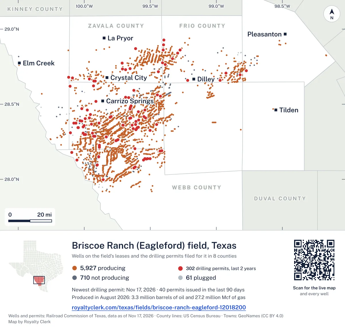
<a href="https://royaltyclerk.com/texas/fields/briscoe-ranch-eagleford-12018200"><img src="https://royaltyclerk.com/maps/field-wells/briscoe-ranch-eagleford-12018200.svg" alt="Map of the wells of the Briscoe Ranch (Eagleford) field, Texas: 6,698 wells and 305 recent drilling locations, in a picture about 159 miles across." width="1000" height="951" loading="lazy" style="max-width:100%;height:auto;border:0"></a>
<p style="margin:4px 0 0;font-size:14px">Map: <a href="https://royaltyclerk.com/texas/fields/briscoe-ranch-eagleford-12018200">Oil and gas wells of the Briscoe Ranch (Eagleford) field, Texas</a> by Royalty Clerk, from Railroad Commission of Texas records</p>
Five years of output in Briscoe Ranch (Eagleford)
Oil output in the Briscoe Ranch (Eagleford) field fell 11% over the last 12 months
44M bbl through Aug 2026, against 49M bbl a year earlier. Peak May 2023: 5M bbl.
Gas output in the Briscoe Ranch (Eagleford) field held steady over the last 12 months
344M mcf through Aug 2026, against 348M mcf a year earlier. Peak Mar 2022: 36M mcf.
SourceTexas Railroad Commission Production Data Query, field 12018200, through Aug 2026, file dated Oct 20, 2026.
Leases in the Briscoe Ranch (Eagleford) field
Under each volume: change on the year before.
- SPR
01-20891Jonah Energy LLCDimmit County
1,112,963bbl oiln/a
956,329bbl oil−1%
847,095bbl oil+31%
633,419bbl oil−15%
620,400bbl oil−20%
485,100bbl oil−45%
459,284bbl oil−8%
450,610bbl oil−25%
420,204bbl oiln/a
413,122bbl oil−44%
390,676bbl oil+121%
353,474bbl oil+261%
345,236bbl oiln/a
343,081bbl oil−20%
331,663bbl oiln/a
281,382bbl oiln/a
257,194bbl oil−52%
256,763bbl oil−21%
240,375bbl oil−36%
233,084bbl oil−11%
228,451bbl oil−33%
213,244bbl oil−39%
201,159bbl oil−4%
199,961bbl oil−33%
196,495bbl oil−60%
Showing 25 of 150 (the 150 largest of 4,407), ranked by output value.
SourceTexas Railroad Commission Production Data Query.
Who operates here, and where
Operators, by oil
Javelin Energy Partners Mgmt leads
- Javelin Energy Partners Mgmt LLC1,601 leases13Mbbl
- Ineos USA Oil & Gas LLC428 leases4.7Mbbl
- Crescent Energy Operating, LLC416 leases3.9Mbbl
- Exco Operating Company, LP135 leases3.6Mbbl
- Murphy Expl. & Prod. Co. - USA44 leases2.5Mbbl
- Rosewood Resources, Inc.46 leases2Mbbl
- Trinity Operating (Usg), LLC220 leases2Mbbl
- Verdun Oil & Gas LLC127 leases1.5Mbbl
Counties, by oil
Dimmit County leads
Recent drilling permits in the Briscoe Ranch (Eagleford) field
DOUBLE RINGER 101HZ #101HZ
new drill · horizontal · Javelin Energy Partners Mgmt LLC · Frio County
Permit 0919737 · Nov 13, 2026
DOUBLE RINGER 101HB #101HB
new drill · horizontal · Javelin Energy Partners Mgmt LLC · Frio County
Permit 0919720 · Nov 10, 2026
DOUBLE RINGER 101HA #101HA
new drill · horizontal · Javelin Energy Partners Mgmt LLC · Frio County
Permit 0919718 · Nov 5, 2026
FERGUSON-MCKNIGHT #D 4OX
new drill · horizontal · Gulftex Energy, LLC · Dimmit County
Permit 0919645 · Oct 29, 2026
FERGUSON-MCKNIGHT #C 3OX
new drill · horizontal · Gulftex Energy, LLC · Dimmit County
Permit 0919646 · Oct 29, 2026
FERGUSON-MCKNIGHT #B 2OX
new drill · horizontal · Gulftex Energy, LLC · Dimmit County
Permit 0919651 · Oct 29, 2026