
RRC operator 126996
Cameron Exploration, Inc.
Cameron Exploration, Inc. reported 2,637 barrels of oil and 57,543 mcf of gas in the last 12 months.
Operator dossier
- Producing leases
- 9of 17 on record
- Counties
- 4
- Biggest county
- Gregg County
- Biggest field
- Willow Springs (Cotton Valley)
Get checks from Cameron Exploration, Inc.?
A family member owned minerals here?
Search their name: a family member who owned minerals hereWhere they work
fewermore
- Gas, last 12 months
- 57,543 mcf
- Fields
- 5
- Data through
- Jul 2026
- Leases on record
- 17
Where Cameron Exploration, Inc. has wells
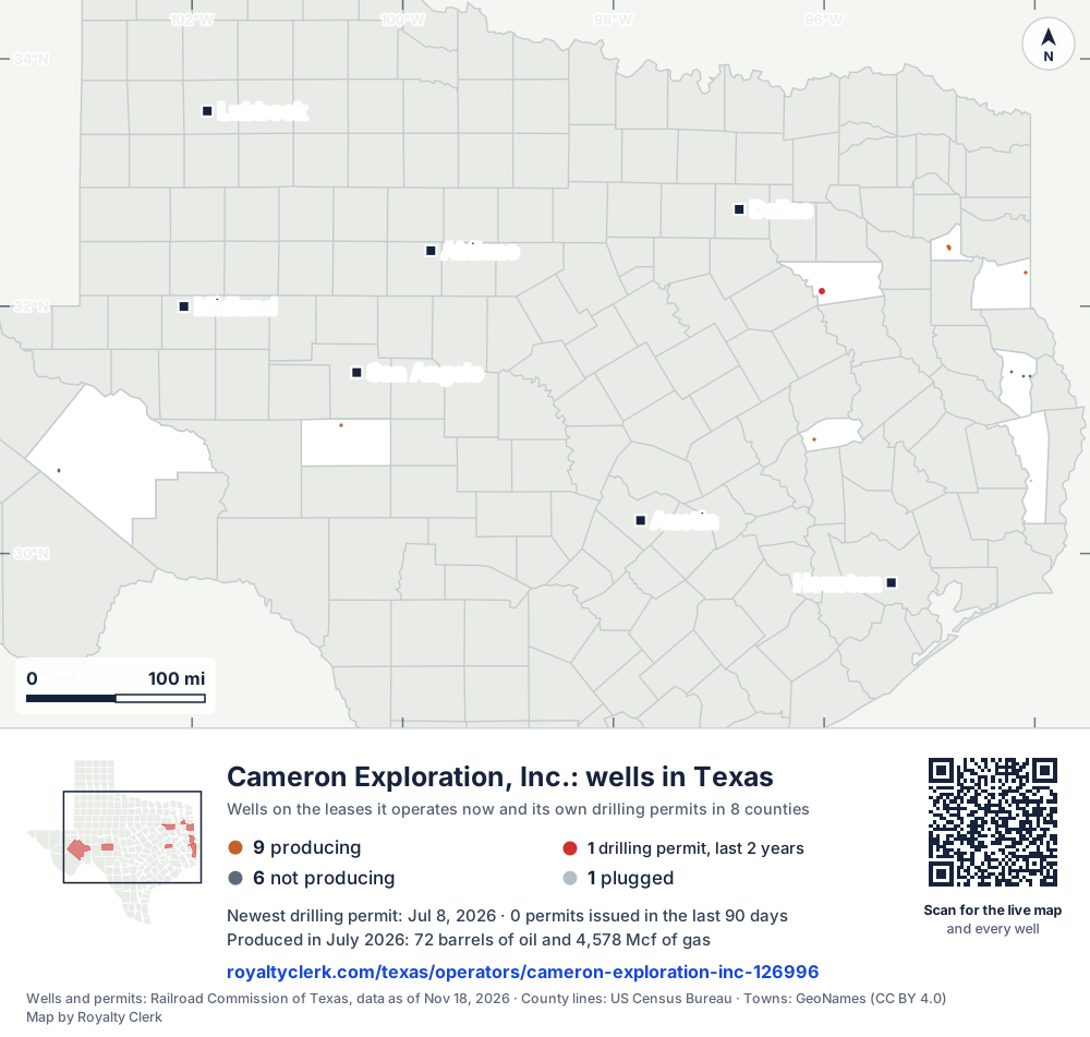
- Drilling locations1Permits issued in the last two years
- Producing wells9On a lease reporting production now
- Not producing6Shut in, inactive or no lease on record
- Plugged1The state's wellbore record says plugged
Each dot is a well on a lease Cameron Exploration, Inc. operates now, where the Railroad Commission's map puts it, or one of its drilling permits of the last 24 months. Wells of other operators are not on this map. The picture is about 610 miles across. The white counties are the ones with a well or drilling permit of its own on the map. Sources: Railroad Commission of Texas well layers and drilling permit files, US Census Bureau county outlines, town points from GeoNames (CC BY 4.0).
Use this map on your site
You may show this map on any site, unchanged. Keep the credit line and its link to Royalty Clerk under the map. The picture updates by itself as the state records new wells and permits.
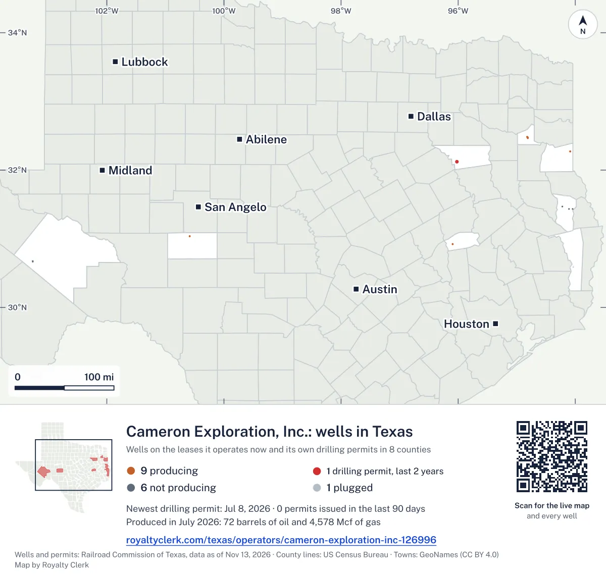
<a href="https://royaltyclerk.com/texas/operators/cameron-exploration-inc-126996"><img src="https://royaltyclerk.com/maps/operator-wells/cameron-exploration-inc-126996.svg" alt="Map of the wells of Cameron Exploration, Inc. in Texas: 16 wells and 1 recent drilling location, in a picture about 610 miles across." width="1000" height="951" loading="lazy" style="max-width:100%;height:auto;border:0"></a>
<p style="margin:4px 0 0;font-size:14px">Map: <a href="https://royaltyclerk.com/texas/operators/cameron-exploration-inc-126996">Oil and gas wells of Cameron Exploration, Inc. in Texas</a> by Royalty Clerk, from Railroad Commission of Texas records</p>
How Cameron Exploration runs its gas and leases
Cameron Exploration, Inc. works mostly in gas. In every full calendar year from 2020 to 2025, gas made more of its output than oil. Gregg County supplies 99.0% of its gas, and 100.0% of its gas went to a line over the last 12 months.
It took over one lease from BVX Operating, Inc. in 2023 and another in 2024. Its highest gas year in this list is 2022. Madison County supplies 92.2% of its oil.
It runs 9 producing leases out of 17, and 7 of its 17 wells are horizontal. Drilling permits came in 2024 and 2026, with one permit in the last 12 months.
Not a forecast, not reserves.
Key moments
- 2022Gas reached 91,550 mcf, the highest gas year in its list.
- 2023Took over one lease from BVX Operating, Inc.
- 2024Took over another lease; gas fell to 56,774 mcf.
- 2025Last full calendar year: 2,915 bbl oil and 56,763 mcf gas.
- 2026Recorded a drilling permit in 2026, the latest year in its file.
If you own here
- Who buys my oil and gas?
Markwest Energy E TX Gas Co, LLC and Midcoast G & P buy from this operator. The tool lists buyers for a lease.
- Why is my royalty check lower?
Gas fell from 91,550 mcf in 2022 to 56,774 mcf in 2024. This tool splits a check drop into its causes.
- Old company, new payor
Cameron took over a lease from BVX Operating, Inc. This tool follows an old company's name changes and sales.
Questions owners ask
- How much has its oil changed since 2020?
- Its oil was 5,063 bbl in 2020 and 2,915 bbl in 2025, the last full calendar year. Its 2026 figures cover only January to July, so they are not a full year.
- Who did this operator take over leases from?
- Cameron Exploration took over one lease from BVX Operating, Inc. in 2023 and another in 2024. BVX Operating, Inc. is the only company it took over leases from in the last 24 months. Old company, new payor
- Where does this operator's gas go?
- In the last 12 months, 100.0% of its gas went to a line. Its main buyers are Markwest Energy E TX Gas Co, LLC and Midcoast G & P (East Texas) L.P., each on one lease. Cameron Exploration, Inc. is listed as buyer on five leases. Who buys my oil and gas?
Related pages
- Gregg County
Gregg County supplies 99.0% of this operator's gas.
- Madison County
Madison County supplies 92.2% of this operator's oil.
- Willow Springs (Cotton Valley)
Five producing leases here, all reporting gas and no oil.
- Fisher, Marvel
Its oldest producing lease, first reported in May 2003.
From the state's records through July 2026.
How its oil and gas changed by year
Oil output from Cameron Exploration, Inc. fell 16% over the last 12 months
2,637 bbl through Jul 2026, against 3,137 bbl a year earlier. Peak Jun 2022: 514 bbl.
Gas output from Cameron Exploration, Inc. held steady over the last 12 months
57.5k mcf through Jul 2026, against 57.8k mcf a year earlier. Peak Feb 2022: 9,688 mcf.
SourceTexas Railroad Commission Production Data Query, operator 126996, through Jul 2026, file dated Oct 20, 2026.
Which leases it runs and which it took over
Under each volume: change on the year before.
2,224bbl oil−14%
30,727mcf gas+7%
21,215mcf gas−10%
4,216mcf gas−7%
171bbl oil+5%
2,291mcf gas+5%
746mcf gas−7%
18bbl oil−62%
191mcf gas+4%
Showing 9 of 9.
SourceTexas Railroad Commission Production Data Query.
Which counties and fields it produces in
Counties, by Cameron Exploration, Inc. oil
Madison County leads
Fields, by Cameron Exploration, Inc. oil
Madisonville, W. (Woodbine -A-) leads
Drilling permits it has filed recently
MALAKOFF SOUTH (BACON LIME) UNIT #26
new drill · Cameron Exploration, Inc. · Henderson County
Permit 0916771 · Jul 8, 2026
BPX #1
new drill · Cameron Exploration, Inc. · Jasper County
Permit 0901420 · Jul 19, 2024
Where the gas of Cameron Exploration, Inc. went
- Plants
- 0.0%
- Pipelines
- 100%
- Lease fuel
- 0.0%
- Flared or vented
- 0.0%
SourceTexas Railroad Commission Production Data Query, last 12 months. What the codes mean
Cameron Exploration, Inc. address and phone number
This is the mailing address and phone Cameron Exploration, Inc. filed with the Texas Railroad Commission. It is the company’s address of record with the state. It can be a regulatory office and not the desk that pays royalties, so a letter about a payment should name the owner relations or division order department, your owner number and the lease name from your stub.
Mailing address
Cameron Exploration, Inc.1201 NW Loop 281 Ste 200
Longview, TX 75604
Phone
State filing
RRC operator 126996 · P-5 status: Active (extension) · last filing received Sep 4, 2026
Writing about a missing or stopped check? See what to ask first or open the company record for its state registration and who buys its oil and gas.
SourceTexas Railroad Commission, P-5 Organization data, file dated Oct 22, 2026. Royalty Clerk is not affiliated with Cameron Exploration, Inc..