
Wilson County, Texas
Oil wells and drilling locations near Floresville
- 285wells
- 16drilling locations in two years
- 89producing leases
Within 10 miles
Wells and drilling locations around Floresville
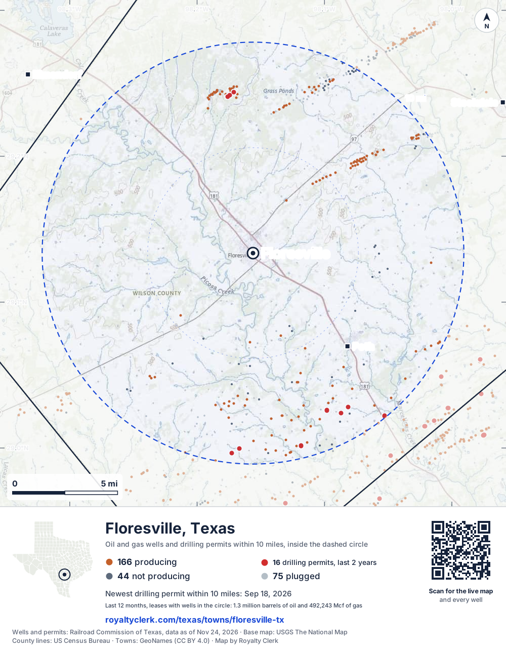
- Drilling locations16Permits issued in the last two years
- Producing wells166On a lease reporting production now
- Not producing44Shut in, inactive or no lease on record
- Plugged75The state's wellbore record says plugged
The dashed circle is 10 miles from the town's point (29.13358, -98.15612); the counts are for wells inside it. Sources: Railroad Commission of Texas well layers and permit files, US Census Bureau county outlines, town points from GeoNames (CC BY 4.0), base map from USGS The National Map.
Use this map on your site
You may show this map on any site, unchanged. Keep the credit line and its link to Royalty Clerk under the map. The picture updates by itself as the state records new wells and permits.
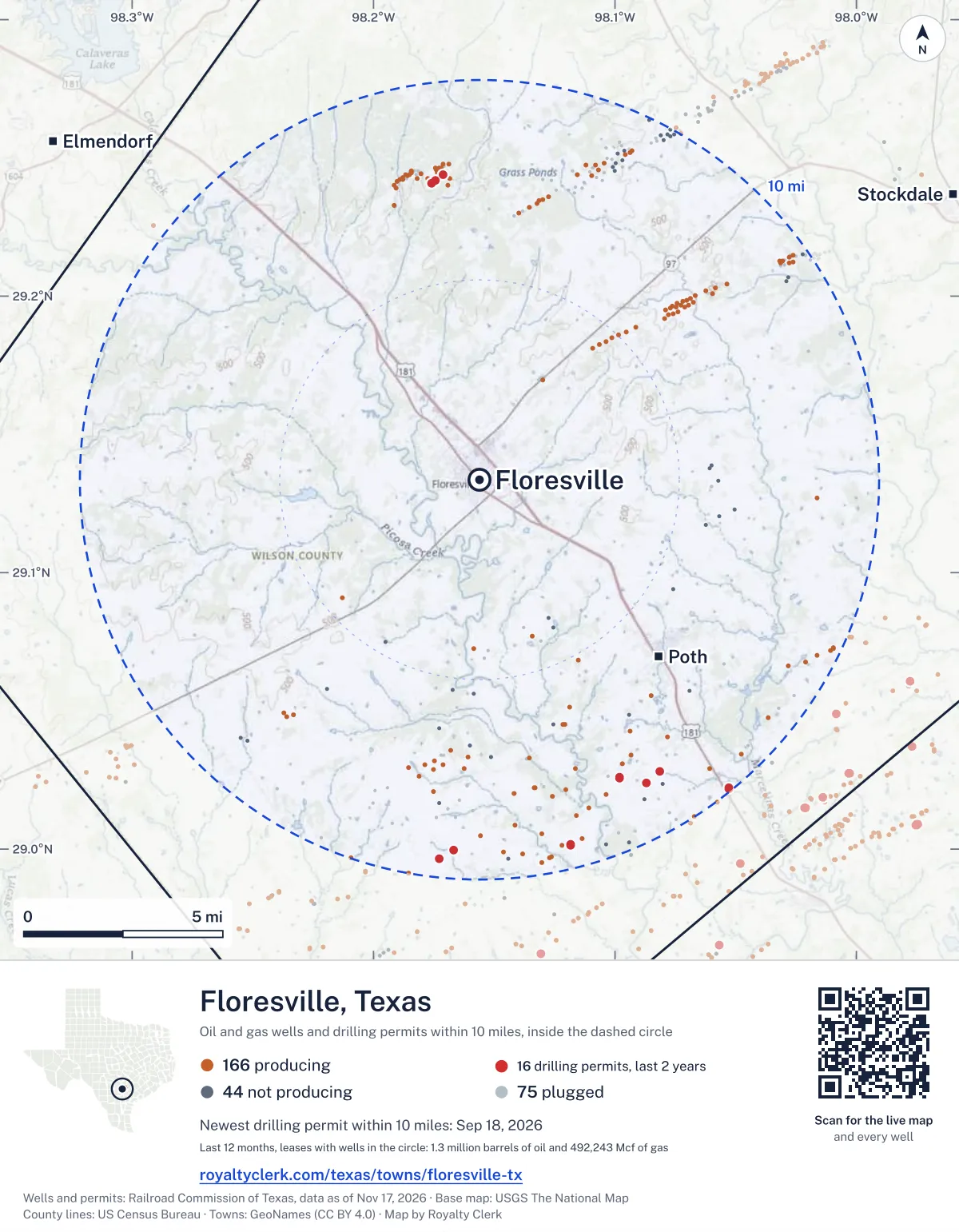
<a href="https://royaltyclerk.com/texas/towns/floresville-tx"><img src="https://royaltyclerk.com/maps/town-wells/floresville-tx.svg" alt="Map of Floresville, Texas: 285 wells and 16 recent drilling locations within 10 miles, inside a dashed circle." width="1000" height="1284" loading="lazy" style="max-width:100%;height:auto;border:0"></a>
<p style="margin:4px 0 0;font-size:14px">Map: <a href="https://royaltyclerk.com/texas/towns/floresville-tx">Floresville, Texas oil and gas wells</a> by Royalty Clerk, from Railroad Commission of Texas records</p>
Which way it is heading
Where the new drilling is around Floresville
What became of the 16 permits
- 12finished, on a lease that reports productionThe well was completed and its lease is reporting oil or gas to the state.
- 4still only a permitNothing after the permit is on file. Many permits wait a year or more, and some are never drilled.
Wells finished in the last two years: 4 south-east, 11 south of town.
A horizontal well runs sideways underground. 31 wells start outside the 10-mile circle and end inside it. 22 start inside and end outside. So a well can drain land a mile or two from the spot where it shows on a map.
A permit is permission to drill, not a well, and a well nearby says nothing about who owns the minerals under it. Direction is taken from the well's surface location. Source: Railroad Commission of Texas drilling permits and wellbore records.
In numbers
Oil and gas within 10 miles of Floresville
- wells with a location on the state's map
- 285
- drilling permits in the last 24 months
- 16
- producing leases with a well in the circle
- 89
- operators running them
- 16
- oil and condensate those leases reported in their latest 12 months
- 1,340,926 bbl
- gas those leases reported in their latest 12 months
- 492,243 mcf
A lease counts when at least one of its wells is inside the circle; its whole production is counted, so a lease reaching beyond the circle counts in full.
In dollars
What the oil and gas near Floresville sold for
- sale value of 12 months, before taxes and costs
- $108 million
- oil and condensate sold
- 1,334,408 bbl
- gas sold
- 409,867 mcf
- the middle lease: half sold more, half less
- $244,584
A 0.01 share (1%) of the middle producing lease near Floresville comes to about $2,446 for the 12 months.
Sold volumes at the public monthly prices, before severance tax and any costs. A guide to the size, not what any owner was paid.
Sold volumes from each lease's monthly report to the Railroad Commission, times the month's West Texas Intermediate oil price and Henry Hub gas price (EIA). Real prices at the lease differ. A lease counts in full when one of its wells is near the town. Check a statement against what the lease sold
Drilling locations
The newest drilling permits near Floresville
| Issued | Lease and well | Where | Operator |
|---|---|---|---|
| 2026-09-18 | JOHNS, OTTO 19vertical · API 42-493-33045 · permit 0918574Titan Opco, LLC | 7.6 mi N29.24381, -98.17113 on OpenStreetMap (opens in a new tab) | Titan Opco, LLC |
| 2026-09-18 | JOHNS, OTTO 18vertical · API 42-493-33044 · permit 0918573Titan Opco, LLC | 7.5 mi N29.24174, -98.17447 on OpenStreetMap (opens in a new tab) | Titan Opco, LLC |
| 2026-09-18 | JOHNS, OTTO 17vertical · API 42-493-33043 · permit 0918571Titan Opco, LLC | 7.5 mi N29.24074, -98.17610 on OpenStreetMap (opens in a new tab) | Titan Opco, LLC |
| 2025-12-04 | LEAGUE GAME 2Hhorizontal · API 42-493-33029 · permit 0912003Warwick-Artemis, LLC | 9.9 mi SE29.02208, -98.05291 on OpenStreetMap (opens in a new tab) | Warwick-Artemis, LLC |
| 2025-12-04 | OVER THE LINE 1Hhorizontal · API 42-493-33028 · permit 0912001Warwick-Artemis, LLC | 9.9 mi SE29.02197, -98.05284 on OpenStreetMap (opens in a new tab) | Warwick-Artemis, LLC |
| 2025-11-14 | JOHNSON 5Hhorizontal · API 42-493-33027 · permit 0911716Hominy Consulting, LLC | 8.2 mi SE29.02589, -98.09819 on OpenStreetMap (opens in a new tab) | Hominy Consulting, LLC |
| 2025-11-14 | JOHNSON 3Hhorizontal · API 42-493-33026 · permit 0911687Hominy Consulting, LLC | 8.2 mi SE29.02584, -98.09826 on OpenStreetMap (opens in a new tab) | Hominy Consulting, LLC |
| 2025-08-25 | DUDES RUG 2Hhorizontal · API 42-493-33024 · permit 0909979Warwick-Artemis, LLC | 9.4 mi S29.00159, -98.11830 on OpenStreetMap (opens in a new tab) | Warwick-Artemis, LLC |
| 2025-08-25 | TIED THE ROOM TOGETHER 1Hhorizontal · API 42-493-33023 · permit 0909975Warwick-Artemis, LLC | 9.4 mi S29.00156, -98.11837 on OpenStreetMap (opens in a new tab) | Warwick-Artemis, LLC |
| 2025-08-22 | NOT A GOLFER 3Hhorizontal · API 42-493-33025 · permit 0909981Warwick-Artemis, LLC | 9.4 mi S29.00163, -98.11824 on OpenStreetMap (opens in a new tab) | Warwick-Artemis, LLC |
| 2025-08-12 | JOHNSON 4Hhorizontal · API 42-493-32554 · permit 0909800Hominy Consulting, LLC | 8.6 mi SE29.02803, -98.08149 on OpenStreetMap (opens in a new tab) | Hominy Consulting, LLC |
| 2025-08-12 | WORLD OF PAIN 4Hhorizontal · API 42-493-33022 · permit 0909768Warwick-Artemis, LLC | 9.2 mi S28.99966, -98.16683 on OpenStreetMap (opens in a new tab) | Warwick-Artemis, LLC |
| 2025-08-12 | SMOKEY MY FRIEND 1Hhorizontal · API 42-493-33021 · permit 0909767Warwick-Artemis, LLC | 9.2 mi S28.99971, -98.16687 on OpenStreetMap (opens in a new tab) | Warwick-Artemis, LLC |
| 2025-07-08 | OUT OF YOUR ELEMENT 3Hhorizontal · API 42-493-33019 · permit 0909021Warwick-Artemis, LLC | 9.5 mi S28.99655, -98.17289 on OpenStreetMap (opens in a new tab) | Warwick-Artemis, LLC |
| 2025-07-07 | TOE BY 3 OCLOCK 4Hhorizontal · API 42-493-33020 · permit 0909022Warwick-Artemis, LLC | 9.5 mi S28.99649, -98.17285 on OpenStreetMap (opens in a new tab) | Warwick-Artemis, LLC |
| 2025-02-21 | JOHNSON 2Hhorizontal · API 42-493-32726 · permit 0905950Hominy Consulting, LLC | 8.6 mi SE29.02386, -98.08699 on OpenStreetMap (opens in a new tab) | Hominy Consulting, LLC |
| 2024-09-19 | SHAWNA WIATREK-SCHIFFERS WEST B 2Hhorizontal · API 42-493-33006 · permit 0902722Warwick-Artemis, LLC | 9.5 mi S28.99632, -98.17347 on OpenStreetMap (opens in a new tab) | Warwick-Artemis, LLC |
| 2024-09-19 | SHAWNA WIATREK-SCHIFFERS WEST A 1Hhorizontal · API 42-493-33005 · permit 0902720Warwick-Artemis, LLC | 9.5 mi S28.99626, -98.17343 on OpenStreetMap (opens in a new tab) | Warwick-Artemis, LLC |
| 2024-09-19 | SHAWNA WIATREK 2Hhorizontal · API 42-493-33007 · permit 0902718Warwick-Artemis, LLC | 9.5 mi S28.99620, -98.17339 on OpenStreetMap (opens in a new tab) | Warwick-Artemis, LLC |
| 2024-09-18 | YOSKO A 2Hhorizontal · API 42-493-33004 · permit 0902723Warwick-Artemis, LLC | 9.5 mi S28.99614, -98.17335 on OpenStreetMap (opens in a new tab) | Warwick-Artemis, LLC |
| 2023-07-10 | THE TUSCAI 64H 64Hhorizontal · API 42-493-32976 · permit 0890995Trinity Operating (Usg), LLC | 9.9 mi S28.99701, -98.20952 on OpenStreetMap (opens in a new tab) | Trinity Operating (Usg), LLC |
| 2023-04-03 | VALCHAR B 2Hhorizontal · API 42-493-32972 · permit 0889395Recoil Resources Operating, Inc. | 8.6 mi S29.01502, -98.11089 on OpenStreetMap (opens in a new tab) | Recoil Resources Operating, Inc. |
| 2023-04-03 | VALCHAR A 1Hhorizontal · API 42-493-32971 · permit 0889393Recoil Resources Operating, Inc. | 8.6 mi S29.01499, -98.11095 on OpenStreetMap (opens in a new tab) | Recoil Resources Operating, Inc. |
A permit is permission to drill, not a well. Distances are from the town's point to the well's surface location. Source: Railroad Commission of Texas drilling permits.
Find your land
The surveys under the new drilling near Floresville
- A-18 MENCHACA, HRS L6 permits, newest December 4, 2025
- A-4 BARRERA, M, section 264 permits, newest August 12, 2025
- A-1 AROCHA, HRS J & S3 permits, newest September 18, 2026
- A-13 FLORES, D G, section 273 permits, newest August 25, 2025
Not in the list? Search every survey in the county by name or abstract number.
Who is on the county roll
43 mineral accounts near Floresville are still in the name of an estate
- mineral accounts on the roll
- 3,402
- owner names
- 1,503
- appraised value of those accounts
- $10 million
- the middle account's appraised value
- $10
- the middle account in all of Wilson County
- $70
- accounts titled to an estate
- 43
An account in the name of an estate usually means the owner died and the title was never moved to the heirs. The account stays on the roll, and these are appraised at $5,458 together. If a parent or grandparent owned minerals near Floresville, their name may be one of them.
Counted the other way: 4,082 royalty-interest records on Texas county mineral rolls (rolls of 2024 to 2026) carry Floresville as their mailing city, wherever in Texas the minerals lie. See the count for every city
Totals from the county appraisal district's mineral roll, matched to leases by the state lease number. No owner is named here, and a count under 10 accounts or 5 owner names is left out. How Wilson County values minerals, and how to protest · Inherited minerals: where to start
Producing leases
Top producing leases near Floresville
- 1World of Pain127,637 bbl · 54,561 mcf a yearWarwick-Artemis, LLC · Wilson County · 1 well in the circle
- 2Out of Your Element123,901 bbl · 44,342 mcf a yearWarwick-Artemis, LLC · Wilson County · 1 well in the circle
- 3Shawna Wiatrek111,264 bbl · 40,858 mcf a yearWarwick-Artemis, LLC · Wilson County · 2 wells in the circle
- 4Shawna Wiatrek-Schiffers West B100,202 bbl · 43,098 mcf a yearWarwick-Artemis, LLC · Wilson County · 1 well in the circle
- 5Shawna Wiatrek-Schiffers West A96,437 bbl · 43,247 mcf a yearWarwick-Artemis, LLC · Wilson County · 1 well in the circle
- 6Toe BY 3 Oclock95,021 bbl · 31,702 mcf a yearWarwick-Artemis, LLC · Wilson County · 1 well in the circle
- 7Over the Line65,776 bbl · 26,162 mcf a yearWarwick-Artemis, LLC · Wilson County · 1 well in the circle
- 8Dudes Rug52,630 bbl · 30,284 mcf a yearWarwick-Artemis, LLC · Wilson County · 1 well in the circle
- 9Johnson56,723 bbl · 0 mcf a yearHominy Consulting, LLC · Wilson County · 5 wells in the circle
- 10League Game44,384 bbl · 19,113 mcf a yearWarwick-Artemis, LLC · Wilson County · 1 well in the circle
- 11Yosko A43,771 bbl · 18,999 mcf a yearWarwick-Artemis, LLC · Wilson County · 1 well in the circle
- 12Not A Golfer44,011 bbl · 9,314 mcf a yearWarwick-Artemis, LLC · Wilson County · 1 well in the circle
- 13Tied the Room Together40,586 bbl · 15,694 mcf a yearWarwick-Artemis, LLC · Wilson County · 1 well in the circle
- 14Smokey MY Friend39,034 bbl · 17,870 mcf a yearWarwick-Artemis, LLC · Wilson County · 1 well in the circle
- 15The Tuscai 64H28,197 bbl · 14,078 mcf a yearTrinity Operating (Usg), LLC · Wilson County · 1 well in the circle
- 16Hosek-Boening B25,073 bbl · 6,389 mcf a yearWarwick-Artemis, LLC · Wilson County · 1 well in the circle
- 17Valchar B16,338 bbl · 5,675 mcf a yearWarwick-Artemis, LLC · Wilson County · 1 well in the circle
- 18LVF Schiffers14,700 bbl · 4,410 mcf a yearFirst Light Operating, LLC · Wilson County · 5 wells in the circle
- 19Hosek-Boening A14,611 bbl · 4,636 mcf a yearWarwick-Artemis, LLC · Wilson County · 1 well in the circle
- 20Patrick Moczygemba B - Geraci 314,260 bbl · 4,112 mcf a yearWarwick-Artemis, LLC · Wilson County · 1 well in the circle
Whose name is on the check
Who buys the oil and gas near Floresville
Oil and condensate
- SHELL TRADING (US) COMPANY62 leases
- ENTERPRISE CRUDE OIL LLC56 leases
- GULFMARK ENERGY, INC.55 leases
- EASTEX CRUDE COMPANY, LLC51 leases
- BP PRODUCTS NORTH AMERICA INC.42 leases
Gas
- ET GATHERING & PROCESSING LLC47 leases
- ENTERPRISE PRODUCTS OPERATING LLC4 leases
- ENERGY TRANSFER COMPANY2 leases
From each lease's newest Form P-4 filing with the Railroad Commission, which names its gatherers and purchasers. One lease can name several.
If your checks stopped
Leases near Floresville that went quiet or changed hands
13 leases reported nothing for a year or more
Leases that reported within the last four years and then stopped. The newest to stop first; 10 shown.
- Schneider, Helen · Texas, Les & Co.last report August 2025
- Flieller, Jerome, JR. · Nordstrand Engineering, Inc.last report June 2025
- Byrd, K.w. · Enr Operating, LLClast report March 2025
- Ocker, D.a. & R.L · Baylor Operating, LLClast report September 2024
- Pena · Baylor Operating, LLClast report September 2024
- Jendrzey Unit · Portentum Energy Co.last report September 2024
- Ocker D.a. & R.l. · Baylor Operating, LLClast report September 2024
- Snoga · Dominion Production Company, LLClast report August 2024
- Valcher, Emma · Dominion Production Company, LLClast report August 2024
- Bates, Hubert L. · Dominion Production Company, LLClast report August 2024
23 leases got a new operator in two years
Checks often pause after a change while the new company sets up its owner records. The newest first; 10 shown.
- Fleeman Nicks Land & Cattle Co.LA Vernia Oil to Fuego Energy, LLCJuly 2026
- E. Floresville /Poth Sand/ UnitA & C Oil Company, LLC to Jaybird Operating, LLCApril 2026
- Hardy, B. B.A & C Oil Company, LLC to Jaybird Operating, LLCApril 2026
- Donaho, W.t. Et AlTriple H Production to Aaronmark Services, LLCJanuary 2026
- Wilson, H. J.Triple H Production to Aaronmark Services, LLCJanuary 2026
- Alexander, Kathleen JonesLP Operating, LLC to Jaybird Operating, LLCNovember 2025
- Ezzell, F.m. ETALWtxr Operating (Texas), Inc. to Petro-Ops, LLCSeptember 2025
- Mills, J. T.Origin Production Company, Inc. to 4 A Rodenberg Heirs LLCAugust 2025
- A.d.d. CorporationFirst Rock, Inc. to First Light Operating, LLCJuly 2025
- Betty Gene PawelekFirst Rock, Inc. to First Light Operating, LLCJuly 2025
From the monthly production reports operators file with the Railroad Commission. The newest months fill in late, so a lease is listed only after 12 months with no report.
Year by year
Production of the leases near Floresville, by year
| Year | Oil, bbl | Gas, mcf |
|---|---|---|
| 2026 so far | 1,071,054 | 411,435 |
| 2025 | 998,039 | 317,132 |
| 2024 | 718,314 | 300,620 |
| 2023 | 701,800 | 292,906 |
| 2022 | 657,387 | 261,839 |
| 2021 | 277,042 | 120,688 |
| 2020 | 247,335 | 95,298 |
Every lease with a well in the circle, producing now or not, as reported to the Railroad Commission. The newest months fill in as operators report.
The long view: in the state's records from January 1993 on, 119 of these leases reported 7,474,748 bbl of oil and condensate and 2,571,487 mcf of gas. Each lease page carries that lease's history back to January 1993.
Good to know
The wells near Floresville, and what a lease has gone for
- depth of the middle well on file
- 7,256 ft
- the deepest on file
- 11,237 ft
Depth and well type from the Railroad Commission's well records, where the record has them. State lease figures from the Texas General Land Office.
Around it
Towns near Floresville
- Poth6.3 mi SE567 wells · 52 permits
- Elmendorf14 mi NW69 wells · 5 permits
- Stockdale14 mi NE500 wells · 0 permits
- La Vernia16 mi N1,190 wells · 5 permits
- Saint Hedwig20 mi N830 wells · 2 permits
- China Grove21 mi NW29 wells · 2 permits
- Pleasanton23 mi SW223 wells · 8 permits
- Karnes City23 mi SE3,348 wells · 203 permits
- Nixon25 mi E554 wells · 12 permits
- Poteet26 mi W40 wells · 0 permits
Floresville is in ZIP code 78114: its wells and permits
All of Wilson County: leases, operators and production · Wilson County well map
Press and community kit
Writing about Floresville? Take what you need
Three facts to quote
- 285 oil and gas wells on the state's map lie within 10 miles of Floresville: 166 on producing leases, 44 not producing and 75 plugged.
- The Railroad Commission of Texas issued 5 drilling permits within 10 miles of Floresville in the last 12 months, the newest dated September 18, 2026.
- The 89 producing leases with a well in that circle, run by 16 operators, reported 1,340,926 barrels of oil and 492,243 thousand cubic feet of gas over their latest 12 months.
The map picture
The page's map with its legend and credit, as a JPEG.


The live map on your page
A frame that loads its picture first and the live map on a tap. No cookies.
How to cite
Railroad Commission of Texas records of the wells and drilling permits within 10 miles of Floresville, mapped by Royalty Clerk (https://royaltyclerk.com/texas/towns/floresville-tx), data as of November 19, 2026.
Under a map or a chart: Source: Railroad Commission of Texas · Map: Royalty Clerk, with a link to this page.
The figures say where the state's records put wells and permits, not who owns the land or the minerals. Kits for other Texas towns
Follow it
Watch the 10 miles around Floresville
Watching a place says nothing about who owns the land or the minerals there. For the whole county, or one survey, use the Wilson County well watch.
FAQ
Questions people ask
How many oil and gas wells are near Floresville?
285 wells with a location on the Railroad Commission's map lie within 10 miles of Floresville: 166 on leases that are producing, 44 not producing and 75 plugged. The state also issued 16 drilling permits with a well location in that circle in the last 24 months.
What are the coordinates on this page?
Latitude and longitude of the well's surface location in NAD83, the coordinates map apps use. They come from the Railroad Commission's well layers as published, and from its drilling permit files, which are published in the older NAD27 and converted here. Paste them into any map app. A horizontal well's bottom hole can be a mile or two away from its surface location.
Do I own minerals under a well near Floresville?
A well nearby says nothing about who owns the minerals under it. The county's mineral roll lists who is paid on each producing lease. Search a name to see whether the Wilson County roll lists it.
Is drilling near Floresville picking up or slowing down?
Drilling permits near Floresville are falling: 5 permits in the last 12 months, 11 in the 12 months before. Most of them are south of town: 13 of 16 lie on that side. The nearest is 7.5 miles north of the town's point. A permit is permission to drill, not a well.
How much are the oil and gas near Floresville worth?
The 89 producing leases with a well within 10 miles sold about $108 million of oil and gas in their newest 12 months on file, at the public monthly prices and before taxes and costs. That is what the leases sold, not what a tract of land or a mineral interest is worth: an owner is paid a share of one lease.
A relative owned minerals near Floresville and has died. What now?
The county mineral roll still lists 43 accounts in the name of an estate on leases near Floresville. Search the family name first. If an account turns up, the title usually has to be moved to the heirs before the operator will pay them.
My checks from a lease here stopped. Why?
The usual reasons: the lease stopped producing, a new operator took it over, or the operator put the payments in suspense over a title or address question. Near Floresville, 13 leases went quiet and 23 changed operator; both lists are on this page.
Own land or minerals near Floresville?
43 accounts near Floresville are still in the name of an estate. See whether a county roll lists your name, and get an email when a permit or a new well is filed near you.
Sources
Primary sources, opened on 29 September 2026. Statute text is the current version on statutes.capitol.texas.gov.