
Hill County, Texas
Oil wells and drilling locations near Itasca
- 191wells
- 1drilling location in two years
- 135producing leases
Within 10 miles
Wells and drilling locations around Itasca
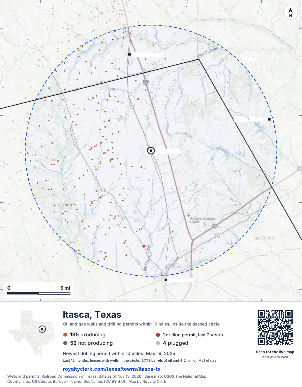
- Drilling locations1Permits issued in the last two years
- Producing wells135On a lease reporting production now
- Not producing52Shut in, inactive or no lease on record
- Plugged4The state's wellbore record says plugged
The dashed circle is 10 miles from the town's point (32.15959, -97.15001); the counts are for wells inside it. Sources: Railroad Commission of Texas well layers and permit files, US Census Bureau county outlines, town points from GeoNames (CC BY 4.0), base map from USGS The National Map.
Use this map on your site
You may show this map on any site, unchanged. Keep the credit line and its link to Royalty Clerk under the map. The picture updates by itself as the state records new wells and permits.
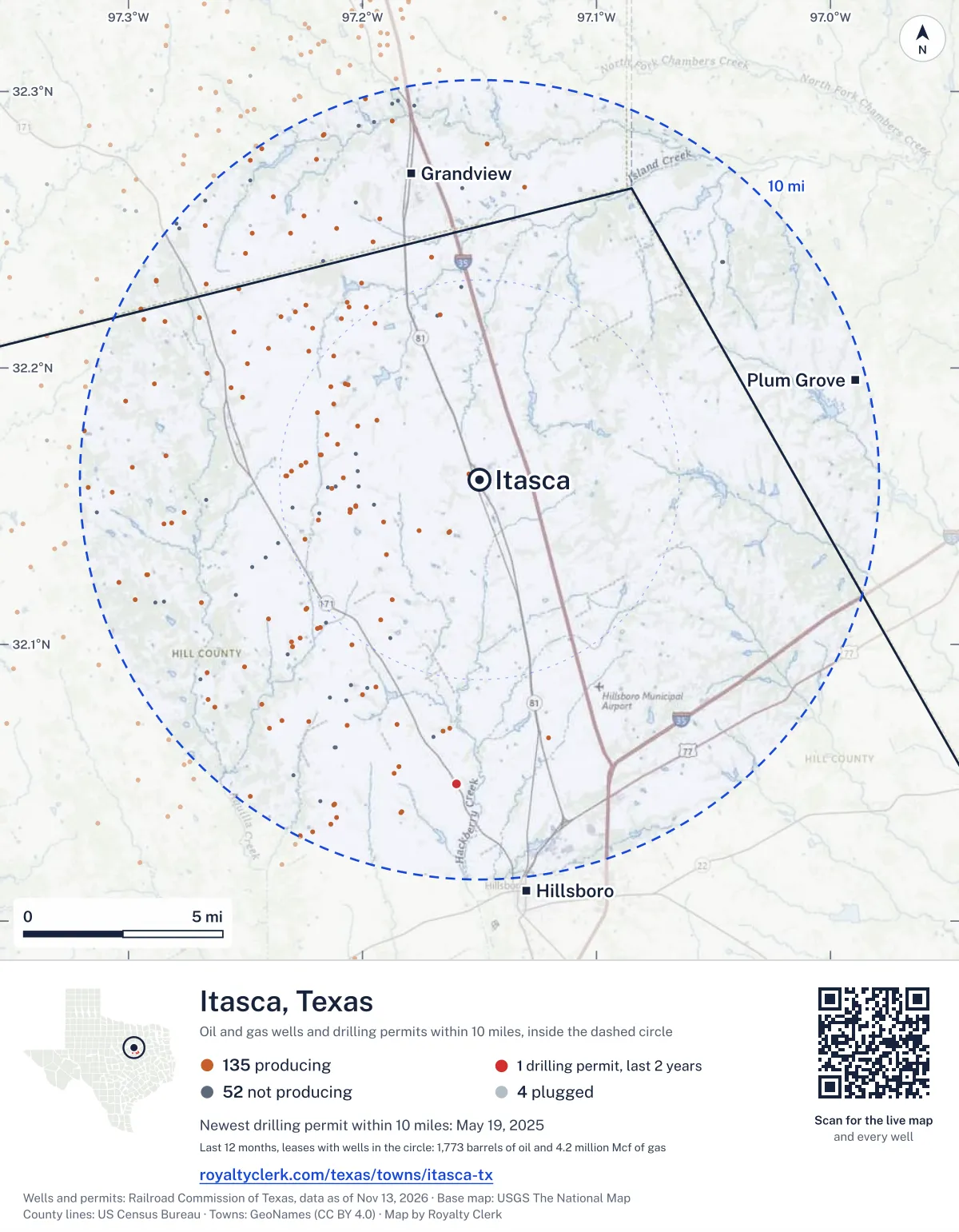
<a href="https://royaltyclerk.com/texas/towns/itasca-tx"><img src="https://royaltyclerk.com/maps/town-wells/itasca-tx.svg" alt="Map of Itasca, Texas: 191 wells and 1 recent drilling locations within 10 miles, inside a dashed circle." width="1000" height="1284" loading="lazy" style="max-width:100%;height:auto;border:0"></a>
<p style="margin:4px 0 0;font-size:14px">Map: <a href="https://royaltyclerk.com/texas/towns/itasca-tx">Itasca, Texas oil and gas wells</a> by Royalty Clerk, from Railroad Commission of Texas records</p>
Which way it is heading
Where the new drilling is around Itasca
What became of the 1 permit
- 1still only a permitNothing after the permit is on file. Many permits wait a year or more, and some are never drilled.
A horizontal well runs sideways underground. 7 wells start outside the 10-mile circle and end inside it. 8 start inside and end outside. So a well can drain land a mile or two from the spot where it shows on a map.
A permit is permission to drill, not a well, and a well nearby says nothing about who owns the minerals under it. Direction is taken from the well's surface location. Source: Railroad Commission of Texas drilling permits and wellbore records.
In numbers
Oil and gas within 10 miles of Itasca
- wells with a location on the state's map
- 191
- drilling permits in the last 24 months
- 1
- producing leases with a well in the circle
- 135
- operators running them
- 6
- oil and condensate those leases reported in their latest 12 months
- 1,773 bbl
- gas those leases reported in their latest 12 months
- 4,216,779 mcf
A lease counts when at least one of its wells is inside the circle; its whole production is counted, so a lease reaching beyond the circle counts in full.
In dollars
What the oil and gas near Itasca sold for
- sale value of 12 months, before taxes and costs
- $15 million
- oil and condensate sold
- 1,726 bbl
- gas sold
- 3,995,208 mcf
- the middle lease: half sold more, half less
- $98,050
A 0.01 share (1%) of the middle producing lease near Itasca comes to about $980 for the 12 months.
Sold volumes at the public monthly prices, before severance tax and any costs. A guide to the size, not what any owner was paid.
Sold volumes from each lease's monthly report to the Railroad Commission, times the month's West Texas Intermediate oil price and Henry Hub gas price (EIA). Real prices at the lease differ. A lease counts in full when one of its wells is near the town. Check a statement against what the lease sold
Drilling locations
The newest drilling permits near Itasca
| Issued | Lease and well | Where | Operator |
|---|---|---|---|
| 2025-05-19 | L-32 32vertical · API 42-217-30773 · permit 0907684Atmos Pipeline - Texas | 7.6 mi S32.04967, -97.15984 on OpenStreetMap (opens in a new tab) | Atmos Pipeline - Texas |
A permit is permission to drill, not a well. Distances are from the town's point to the well's surface location. Source: Railroad Commission of Texas drilling permits.
Find your land
The surveys under the new drilling near Itasca
- A-139 CUPEE, HRS J1 permit, newest May 19, 2025
Not in the list? Search every survey in the county by name or abstract number.
Who is on the county roll
43 mineral accounts near Itasca are still in the name of an estate
- mineral accounts on the roll
- 3,825
- owner names
- 1,538
- appraised value of those accounts
- $2.9 million
- the middle account's appraised value
- $0
- the middle account in all of Hill County
- $0
- accounts titled to an estate
- 43
An account in the name of an estate usually means the owner died and the title was never moved to the heirs. The account stays on the roll, and these are appraised at $16,515 together. If a parent or grandparent owned minerals near Itasca, their name may be one of them.
Totals from the county appraisal district's mineral roll, matched to leases by the state lease number. No owner is named here, and a count under 10 accounts or 5 owner names is left out. How Hill County values minerals, and how to protest · Inherited minerals: where to start
Producing leases
Top producing leases near Itasca
- 1Bentley0 bbl · 115,708 mcf a yearEagleridge Operating, LLC · Hill County · 1 well in the circle
- 2Ellig0 bbl · 109,733 mcf a yearEagleridge Operating, LLC · Hill County · 1 well in the circle
- 3Cole0 bbl · 91,822 mcf a yearEagleridge Operating, LLC · Hill County · 1 well in the circle
- 4Ellig0 bbl · 83,533 mcf a yearEagleridge Operating, LLC · Hill County · 1 well in the circle
- 5Mears0 bbl · 81,883 mcf a yearEagleridge Operating, LLC · Hill County · 1 well in the circle
- 6Goldsmith Hilton Unit0 bbl · 62,808 mcf a yearEagleridge Operating, LLC · Hill County · 1 well in the circle
- 7Smitherman47 bbl · 62,410 mcf a yearEagleridge Operating, LLC · Hill County · 1 well in the circle
- 8Patricia0 bbl · 62,108 mcf a yearEagleridge Operating, LLC · Hill County · 1 well in the circle
- 9Colonial Trust0 bbl · 57,398 mcf a yearEagleridge Operating, LLC · Hill County · 1 well in the circle
- 10Castle0 bbl · 57,073 mcf a yearFormentera Operations LLC · Hill County · 1 well in the circle
- 11Cole0 bbl · 55,129 mcf a yearEagleridge Operating, LLC · Hill County · 1 well in the circle
- 12Livingstone0 bbl · 54,175 mcf a yearFormentera Operations LLC · Johnson County · 1 well in the circle
- 13Fehse, J. J. Gu0 bbl · 51,730 mcf a yearFormentera Operations LLC · Johnson County · 1 well in the circle
- 14Fehse, J. J. Gu0 bbl · 51,530 mcf a yearFormentera Operations LLC · Johnson County · 1 well in the circle
- 15Young0 bbl · 51,029 mcf a yearEagleridge Operating, LLC · Hill County · 1 well in the circle
- 16Ross Unit0 bbl · 50,762 mcf a yearFormentera Operations LLC · Hill County · 1 well in the circle
- 17Jeans Unit0 bbl · 50,327 mcf a yearEagleridge Operating, LLC · Hill County · 1 well in the circle
- 18Tommy Ray0 bbl · 49,931 mcf a yearEagleridge Operating, LLC · Hill County · 1 well in the circle
- 19James Conn IV0 bbl · 49,258 mcf a yearFormentera Operations LLC · Hill County · 1 well in the circle
- 20Clark0 bbl · 47,734 mcf a yearEagleridge Operating, LLC · Hill County · 1 well in the circle
Whose name is on the check
Who buys the oil and gas near Itasca
Oil and condensate
- ENERGY TRANS CRUDE MARKETING LLC54 leases
- ENERGY TRANSFER MARKETING & TERM18 leases
- GULFMARK ENERGY, INC.2 leases
- SHELL TRADING (US) COMPANY2 leases
Gas
- BLACKBEARD OPERATING, LLC54 leases
- JAVELIN MARKETING, LLC39 leases
- ENLINK GAS MARKETING, LP15 leases
- DIVERSIFIED PRODUCTION LLC12 leases
- EAGLERIDGE OPERATING, LLC9 leases
From each lease's newest Form P-4 filing with the Railroad Commission, which names its gatherers and purchasers. One lease can name several.
If your checks stopped
Leases near Itasca that went quiet or changed hands
4 leases reported nothing for a year or more
Leases that reported within the last four years and then stopped. The newest to stop first.
- Miller, Dan · Tep Barnett USA, LLClast report January 2024
- Brown, Bill · Eagleridge Operating, LLClast report August 2023
- Brown, Bill · Eagleridge Operating, LLClast report August 2023
- Menchaca, Nicholas · Javelin Energy Partners Mgmt LLClast report October 2022
151 leases got a new operator in two years
Checks often pause after a change while the new company sets up its owner records. The newest first; 10 shown.
- BaccusDiversified Production LLC to Eagleridge Operating, LLCJuly 2026
- BentleyDiversified Production LLC to Eagleridge Operating, LLCJuly 2026
- BentleyDiversified Production LLC to Eagleridge Operating, LLCJuly 2026
- Bill the CatDiversified Production LLC to Eagleridge Operating, LLCJuly 2026
- BoxDiversified Production LLC to Eagleridge Operating, LLCJuly 2026
- Brooks UnitDiversified Production LLC to Eagleridge Operating, LLCJuly 2026
- Burt TrustDiversified Production LLC to Eagleridge Operating, LLCJuly 2026
- Burt TrustDiversified Production LLC to Eagleridge Operating, LLCJuly 2026
- Campbell UnitDiversified Production LLC to Eagleridge Operating, LLCJuly 2026
- ClarkDiversified Production LLC to Eagleridge Operating, LLCJuly 2026
From the monthly production reports operators file with the Railroad Commission. The newest months fill in late, so a lease is listed only after 12 months with no report.
Year by year
Production of the leases near Itasca, by year
| Year | Oil, bbl | Gas, mcf |
|---|---|---|
| 2026 so far | 1,712 | 2,777,654 |
| 2025 | 61 | 4,411,820 |
| 2024 | 4 | 4,916,068 |
| 2023 | 4 | 5,125,688 |
| 2022 | 25 | 5,741,777 |
| 2021 | 24 | 5,892,714 |
| 2020 | 130 | 6,435,051 |
Every lease with a well in the circle, producing now or not, as reported to the Railroad Commission. The newest months fill in as operators report.
The long view: in the state's records from July 2004 on, 190 of these leases reported 305 bbl of oil and condensate and 187,162,284 mcf of gas. Each lease page carries that lease's history back to January 1993.
Around it
Towns near Itasca
- Grandview7.8 mi N403 wells · 1 permits
- Plum Grove9.7 mi E5 wells · 0 permits
- Hillsboro10 mi S81 wells · 1 permits
- Italy16 mi E1 wells · 0 permits
- Alvarado17 mi N1,422 wells · 2 permits
- Whitney17 mi SW52 wells · 0 permits
- Cleburne19 mi NW1,485 wells · 0 permits
- Venus19 mi N1,004 wells · 6 permits
- Keene19 mi NW1,903 wells · 1 permits
- Nash21 mi E0 wells · 0 permits
Itasca is in ZIP code 76055: its wells and permits
All of Hill County: leases, operators and production · Hill County well map
Follow it
Watch the 10 miles around Itasca
Watching a place says nothing about who owns the land or the minerals there. For the whole county, or one survey, use the Hill County well watch.
FAQ
Questions people ask
How many oil and gas wells are near Itasca?
191 wells with a location on the Railroad Commission's map lie within 10 miles of Itasca: 135 on leases that are producing, 52 not producing and 4 plugged. The state also issued 1 drilling permit with a well location in that circle in the last 24 months.
What are the coordinates on this page?
Latitude and longitude of the well's surface location in NAD83, the coordinates map apps use. They come from the Railroad Commission's well layers as published, and from its drilling permit files, which are published in the older NAD27 and converted here. Paste them into any map app. A horizontal well's bottom hole can be a mile or two away from its surface location.
Do I own minerals under a well near Itasca?
A well nearby says nothing about who owns the minerals under it. The county's mineral roll lists who is paid on each producing lease. Search a name to see whether the Hill County roll lists it.
Is drilling near Itasca picking up or slowing down?
Drilling permits near Itasca are holding steady: 0 permits in the last 12 months, 1 in the 12 months before. The nearest is 7.6 miles south of the town's point. A permit is permission to drill, not a well.
How much are the oil and gas near Itasca worth?
The 135 producing leases with a well within 10 miles sold about $15 million of oil and gas in their newest 12 months on file, at the public monthly prices and before taxes and costs. That is what the leases sold, not what a tract of land or a mineral interest is worth: an owner is paid a share of one lease.
A relative owned minerals near Itasca and has died. What now?
The county mineral roll still lists 43 accounts in the name of an estate on leases near Itasca. Search the family name first. If an account turns up, the title usually has to be moved to the heirs before the operator will pay them.
My checks from a lease here stopped. Why?
The usual reasons: the lease stopped producing, a new operator took it over, or the operator put the payments in suspense over a title or address question. Near Itasca, 4 leases went quiet and 151 changed operator; both lists are on this page.
Own land or minerals near Itasca?
43 accounts near Itasca are still in the name of an estate. See whether a county roll lists your name, and get an email when a permit or a new well is filed near you.
Sources
Primary sources, opened on 29 September 2026. Statute text is the current version on statutes.capitol.texas.gov.