
Ward County, Texas
Ward County drilling permits: what the state recorded
- 123drilling permits
- 67completions
- 18first-production reports
- in the last twelve months
Wells by coordinates
Oil wells and drilling locations in Ward County
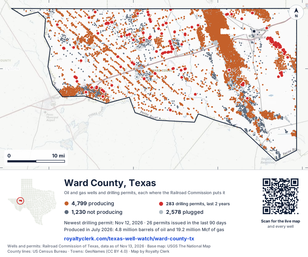
- Drilling locations283Permits issued in the last two years
- Producing wells4,799On a lease reporting production now
- Not producing1,230Shut in, inactive or no lease on record
- Plugged2,578The state's wellbore record says plugged
Sources: Railroad Commission of Texas well layers and permit files, US Census Bureau county outline, town points from GeoNames (CC BY 4.0), base map from USGS The National Map. A dot is a surface location; a horizontal well runs a mile or more from it.
8,607 wells with a location on the state's map and 283 drilling locations permitted in the last 24 months, each where the Railroad Commission puts it.
A permit is not a well.
Wells near each town in Ward County
Wells within 10 miles of each town, on either side of the county line.
Use this map on your site
You may show this map on any site, unchanged. Keep the credit line and its link to Royalty Clerk under the map. The picture updates by itself as the state records new wells and permits.
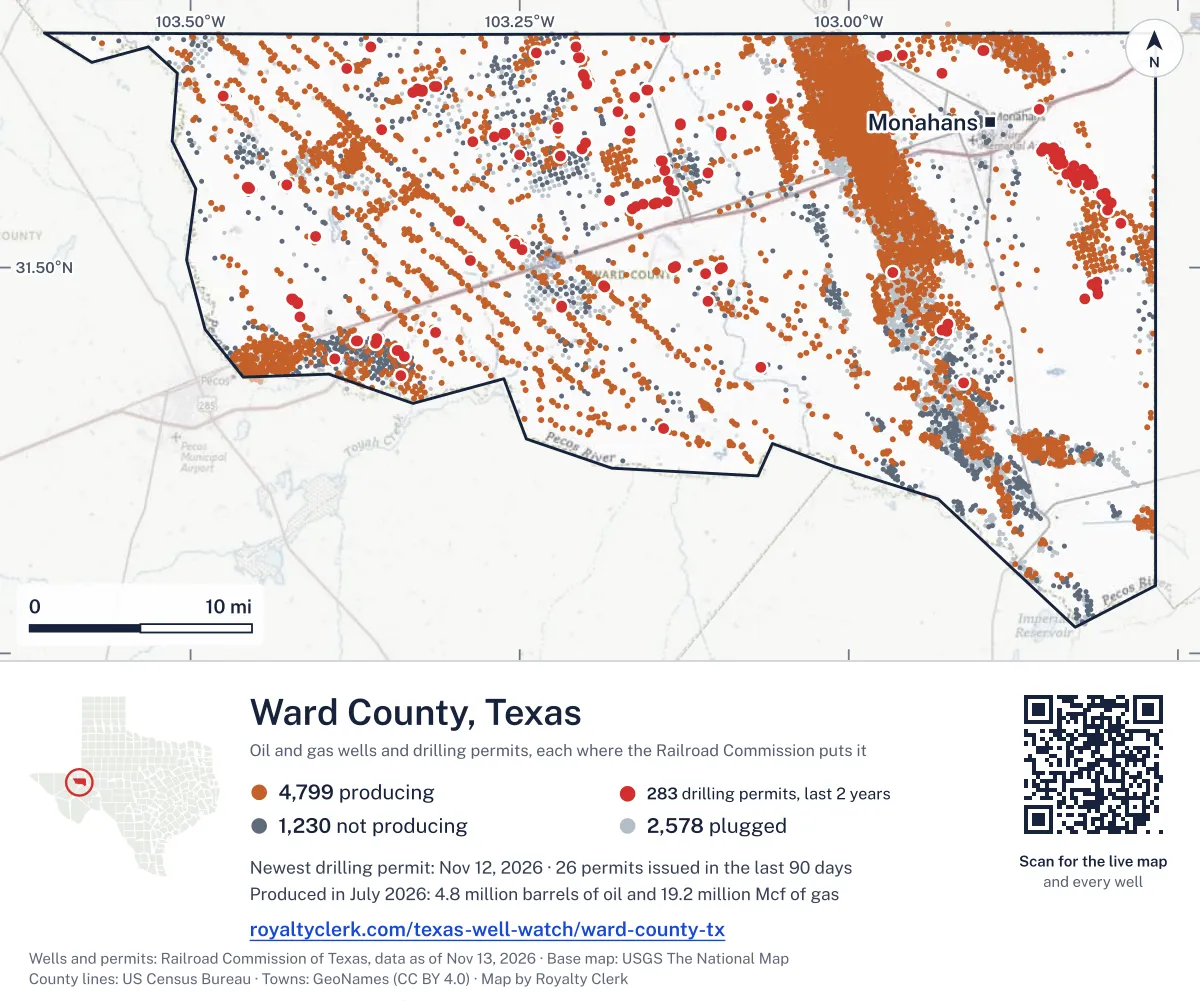
<a href="https://royaltyclerk.com/texas-well-watch/ward-county-tx"><img src="https://royaltyclerk.com/maps/county-wells/ward-county-tx.svg" alt="Map of Ward County, Texas, with 8,607 oil and gas wells and 283 recent drilling locations as dots." width="1000" height="834" loading="lazy" style="max-width:100%;height:auto;border:0"></a>
<p style="margin:4px 0 0;font-size:14px">Map: <a href="https://royaltyclerk.com/texas-well-watch/ward-county-tx">Ward County, Texas oil and gas wells</a> by Royalty Clerk, from Railroad Commission of Texas records</p>
The last twelve months
Month by month in Ward County
| Month | Permits | Completions | First production |
|---|---|---|---|
| Nov 2026 | 3 | 0 | 0 |
| Oct 2026 | 7 | 0 | 0 |
| Sep 2026 | 12 | 0 | 0 |
| Aug 2026 | 14 | 2 | 0 |
| Jul 2026 | 8 | 1 | 1 |
| Jun 2026 | 16 | 3 | 1 |
| May 2026 | 15 | 1 | 0 |
| Apr 2026 | 19 | 12 | 5 |
| Mar 2026 | 6 | 3 | 0 |
| Feb 2026 | 2 | 2 | 0 |
| Jan 2026 | 11 | 5 | 2 |
| Dec 2025 | 8 | 32 | 9 |
| Nov 2025 | 2 | 6 | 0 |
Counted from November 16, 2025 to November 12, 2026, so the first and last months are partial. Source: Railroad Commission of Texas data sets.
Free, no sign-in
The newest drilling permits in Ward County
| Issued | Lease and well | Operator | Drilling began | Depth, ft | API number | Coordinates | Permit |
|---|---|---|---|---|---|---|---|
| 2026-11-12 | VULCAN 2-3 H 303HRnew drill · horizontalMCM Operating, LLCAPI 42-475-39129 · permit 092010611,000 ft | MCM Operating, LLC | |||||
| 2026-11-02 | EAGER BEAVER 58/47 A F101DAnew drill · horizontalMewbourne Oil CompanyAPI 42-475-39127 · permit 091983131.43512, -103.0671713,460 ft | Mewbourne Oil Company | |||||
| 2026-11-02 | ALL AMERICAN 57/48 A F101MPnew drill · horizontalMewbourne Oil CompanyAPI 42-475-39128 · permit 091983231.43516, -103.0671313,950 ft | Mewbourne Oil Company | |||||
| 2026-10-30 | SEALY RANCH 5603Hnew drill · horizontalHalcon Operating Co., Inc.API 42-475-39124 · permit 091982131.60518, -103.0771513,000 ft | Halcon Operating Co., Inc. | |||||
| 2026-10-30 | SEALY RANCH 5602Hnew drill · horizontalHalcon Operating Co., Inc.API 42-475-39123 · permit 091982031.60516, -103.0772313,000 ft | Halcon Operating Co., Inc. | |||||
| 2026-10-16 | SWOOSE 84/82 B F101BGnew drill · horizontalMewbourne Oil CompanyAPI 42-475-39122 · permit 091929431.59282, -103.1280814,750 ft | Mewbourne Oil Company | |||||
| 2026-10-16 | SWOOSE 84/82 A F101AHnew drill · horizontalMewbourne Oil CompanyAPI 42-475-39121 · permit 091929231.59284, -103.1280214,600 ft | Mewbourne Oil Company | |||||
| 2026-10-08 | YANKEE LADY 85/86 A F101PAnew drill · horizontalMewbourne Oil CompanyAPI 42-475-39119 · permit 091915431.59287, -103.1279015,550 ft | Mewbourne Oil Company | |||||
| 2026-10-08 | YANKEE LADY 85/86 B F101OBnew drill · horizontalMewbourne Oil CompanyAPI 42-475-39120 · permit 091915531.59286, -103.1279615,680 ft | Mewbourne Oil Company | |||||
| 2026-10-02 | C. W. EDWARDS ET AL 17recompletion · verticalPitts Energy Co.API 42-475-33893 · permit 091900231.55507, -102.827315,609 ft | Pitts Energy Co. | |||||
| 2026-09-18 | EDWARDS, JACK -H- 1recompletion · verticalPitts Energy Co.API 42-475-10370 · permit 091780831.54759, -102.808365,350 ft | Pitts Energy Co. | |||||
| 2026-09-15 | EDWARDS, C. W. ET AL 14recompletion · verticalPitts Energy Co.API 42-475-33833 · permit 091793531.56605, -102.828935,600 ft | Pitts Energy Co. | |||||
| 2026-09-15 | ROYAL FLUSH 95/97 A F101APnew drill · horizontalMewbourne Oil CompanyAPI 42-475-39113 · permit 091825531.61491, -103.1529015,851 ft | Mewbourne Oil Company | |||||
| 2026-09-14 | ROYAL FLUSH 95/97 D F101DMnew drill · horizontalMewbourne Oil CompanyAPI 42-475-39116 · permit 091826031.61471, -103.1536415,771 ft | Mewbourne Oil Company | |||||
| 2026-09-14 | ROYAL FLUSH 95/97 C F101CNnew drill · horizontalMewbourne Oil CompanyAPI 42-475-39115 · permit 091825931.61473, -103.1535815,871 ft | Mewbourne Oil Company | |||||
| 2026-09-14 | ROYAL FLUSH 95/97 B F101BOnew drill · horizontalMewbourne Oil CompanyAPI 42-475-39114 · permit 091825831.61490, -103.1529615,811 ft | Mewbourne Oil Company | |||||
| 2026-09-11 | SEALY SMITH FOUNDATION 4301Hnew drill · horizontalOccidental Permian Ltd.API 42-475-39111 · permit 091817531.64072, -102.897929,000 ft | Occidental Permian Ltd. | |||||
| 2026-09-10 | EDWARDS, JNO. ET AL B 4recompletion · verticalPitts Energy Co.API 42-475-33944 · permit 091669331.57398, -102.844066,000 ft | Pitts Energy Co. | |||||
| 2026-09-04 | SEALY SMITH FOUNDATION 4303Hnew drill · horizontalOccidental Permian Ltd.API 42-475-39118 · permit 091821331.64077, -102.897709,000 ft | Occidental Permian Ltd. | |||||
| 2026-09-04 | SEALY SMITH FOUNDATION 4302Hnew drill · horizontalOccidental Permian Ltd.API 42-475-39117 · permit 091821131.64075, -102.897819,000 ft | Occidental Permian Ltd. | |||||
| 2026-09-02 | EDWARDS, JACK ET AL 2recompletion · verticalPitts Energy Co.API 42-475-10773 · permit 091672531.55409, -102.814755,450 ft | Pitts Energy Co. | |||||
| 2026-09-02 | UL AIR FORCE I 9Anew drill · horizontalCrescent Energy Operating, LLCAPI 42-475-39112 · permit 091822231.61733, -103.3144312,500 ft | Crescent Energy Operating, LLC | |||||
| 2026-08-27 | EDWARDS, C. W., ET AL 4recompletion · verticalPitts Energy Co.API 42-475-10037 · permit 091733731.55984, -102.820725,392 ft | Pitts Energy Co. | |||||
| 2026-08-26 | EDWARDS, JACK -J- 2recompletion · verticalPitts Energy Co.API 42-475-31860 · permit 091756731.54451, -102.804385,400 ft | Pitts Energy Co. | |||||
| 2026-08-21 | VULCAN 2-3 E 402Hnew drill · horizontalMCM Operating, LLCAPI 42-475-39110 · permit 091779931.55162, -103.45631drilling began 2026-10-25 · 11,000 ft | MCM Operating, LLC | |||||
| 2026-08-20 | EDWARDS, C. W. ET AL 19recompletion · verticalPitts Energy Co.API 42-475-33977 · permit 091793431.57103, -102.839005,709 ft | Pitts Energy Co. | |||||
| 2026-08-17 | EDWARDS 4 2recompletion · verticalWilliams Oil CompanyAPI 42-475-35276 · permit 091788231.52891, -102.793206,507 ft | Williams Oil Company | |||||
| 2026-08-14 | VULCAN 2-3 J 304Hnew drill · horizontalMCM Operating, LLCAPI 42-475-39109 · permit 091781131.55185, -103.45661drilling began 2026-10-29 · 11,000 ft | MCM Operating, LLC | |||||
| 2026-08-14 | VULCAN 2-3 I 404Hnew drill · horizontalMCM Operating, LLCAPI 42-475-39108 · permit 091781031.55181, -103.4565511,000 ft | MCM Operating, LLC | |||||
| 2026-08-14 | VULCAN 2-3 H 303Hnew drill · horizontalMCM Operating, LLCAPI 42-475-39107 · permit 091780731.55176, -103.4564911,000 ft | MCM Operating, LLC | |||||
| 2026-08-14 | VULCAN 2-3 G 403Hnew drill · horizontalMCM Operating, LLCAPI 42-475-39106 · permit 091780431.55171, -103.4564311,000 ft | MCM Operating, LLC | |||||
| 2026-08-14 | VULCAN 2-3 F 302Hnew drill · horizontalMCM Operating, LLCAPI 42-475-39105 · permit 091780131.55167, -103.45637drilling began 2026-10-26 · 11,000 ft | MCM Operating, LLC | |||||
| 2026-08-13 | EDWARDS, JACK -L- 3recompletion · verticalPitts Energy Co.API 42-475-33646 · permit 091776131.53729, -102.803505,590 ft | Pitts Energy Co. | |||||
| 2026-08-10 | C. W. EDWARDS ET AL 8recompletion · verticalPitts Energy Co.API 42-475-10041 · permit 091764231.56043, -102.834175,400 ft | Pitts Energy Co. | |||||
| 2026-08-10 | EDWARDS, C. W. ET AL 9recompletion · verticalPitts Energy Co.API 42-475-10042 · permit 091752431.56345, -102.821495,400 ft | Pitts Energy Co. | |||||
| 2026-08-04 | EDWARDS, C. W. ET AL 15recompletion · verticalPitts Energy Co.API 42-475-31983 · permit 091737431.55725, -102.815495,500 ft | Pitts Energy Co. | |||||
| 2026-07-23 | KOEHN 8reclass · verticalGoodnight Midstream Permian, LLCAPI 42-475-37710 · permit 091537431.47968, -102.820724,200 ft | Goodnight Midstream Permian, LLC | |||||
| 2026-07-21 | SMASHBOY 1-29 B B201HSnew drill · horizontalPetro-Hunt Permian, LLCAPI 42-475-39096 · permit 091722131.61097, -103.4752712,500 ft | Petro-Hunt Permian, LLC | |||||
| 2026-07-21 | SMASHBOY 1-29 A B101HSnew drill · horizontalPetro-Hunt Permian, LLCAPI 42-475-39095 · permit 091722031.61103, -103.4753412,500 ft | Petro-Hunt Permian, LLC | |||||
| 2026-07-10 | EDWARDS, JNO. ET AL 'B' 9recompletion · verticalPitts Energy Co.API 42-475-34003 · permit 091702531.57747, -102.844205,566 ft | Pitts Energy Co. | |||||
| 2026-07-10 | EDWARDS, JNO. ET AL 'B' 7recompletion · verticalPitts Energy Co.API 42-475-33959 · permit 091700431.57492, -102.839955,598 ft | Pitts Energy Co. | |||||
| 2026-07-10 | EDWARDS, JNO. ETAL -B- 6recompletion · verticalPitts Energy Co.API 42-475-33958 · permit 091700031.57554, -102.853395,722 ft | Pitts Energy Co. | |||||
| 2026-07-07 | EDWARDS, JNO. ET AL B 3recompletion · verticalPitts Energy Co.API 42-475-33930 · permit 091670031.57706, -102.848107,000 ft | Pitts Energy Co. | |||||
| 2026-07-01 | EDWARDS, JNO. ET AL B 5recompletion · verticalPitts Energy Co.API 42-475-33943 · permit 091674931.57776, -102.851915,700 ft | Pitts Energy Co. | |||||
| 2026-06-26 | EDWARDS C.W. ET AL 16recompletion · verticalPitts Energy Co.API 42-475-32420 · permit 091672631.56054, -102.818385,530 ft | Pitts Energy Co. | |||||
| 2026-06-25 | GARFIELD C 8908Hnew drill · horizontalHalcon Operating Co., Inc.API 42-475-39089 · permit 091666731.64907, -103.13944drilling began 2026-08-17 · 13,000 ft | Halcon Operating Co., Inc. | |||||
| 2026-06-25 | GARFIELD B 8907Hnew drill · horizontalHalcon Operating Co., Inc.API 42-475-39088 · permit 091666631.64901, -103.13941drilling began 2026-08-16 · 13,000 ft | Halcon Operating Co., Inc. | |||||
| 2026-06-24 | UL GOOD BULL 301BCnew drill · horizontalAdmiral Permian Operating LLCAPI 42-475-39086 · permit 091660331.61596, -103.3272111,500 ft | Admiral Permian Operating LLC | |||||
| 2026-06-24 | UL GOOD BULL 201SHnew drill · horizontalAdmiral Permian Operating LLCAPI 42-475-39085 · permit 091660231.61589, -103.3274410,000 ft | Admiral Permian Operating LLC | |||||
| 2026-06-24 | UL GOOD BULL 1WCnew drill · horizontalAdmiral Permian Operating LLCAPI 42-475-39084 · permit 091660131.61607, -103.3277312,500 ft | Admiral Permian Operating LLC |
These are the newest 50 of 585 permits on file for Ward County. The rest follow, 50 to a page.
A permit is permission to drill, not a well. Source: Railroad Commission of Texas drilling permit files.
Year by year
Drilling permits issued in Ward County, by year
| Year | Permits issued |
|---|---|
| 2026 so far | 113 |
| 2025 | 138 |
| 2024 | 168 |
| 2023 | 98 |
| 2022 | 29 |
| 2021 | 1 |
| 2020 | 3 |
| 2019 | 20 |
| 2018 | 4 |
| 2017 | 6 |
| 2015 | 2 |
| 2014 | 2 |
| 2007 | 1 |
Counted from the permit files we hold, which start in 2007; that first year may be partial. Source: Railroad Commission of Texas drilling permit files.
The latest
The most recent records
| Date | What, who and where |
|---|---|
| 2026-11-12 | Permit issued: MCM Operating, LLCVULCAN 2-3 H · A-326 · permit 0920106 |
| 2026-11-02 | Permit issued: Mewbourne Oil CompanyEAGER BEAVER 58/47 A · A-700 · permit 0919831 |
| 2026-11-02 | Permit issued: Mewbourne Oil CompanyALL AMERICAN 57/48 A · A-700 · permit 0919832 |
| 2026-10-30 | Permit issued: Halcon Operating Co., Inc.SEALY RANCH · A-25 · permit 0919821 |
| 2026-10-30 | Permit issued: Halcon Operating Co., Inc.SEALY RANCH · A-25 · permit 0919820 |
| 2026-10-16 | Permit issued: Mewbourne Oil CompanySWOOSE 84/82 B · A-45 · permit 0919294 |
| 2026-10-16 | Permit issued: Mewbourne Oil CompanySWOOSE 84/82 A · A-45 · permit 0919292 |
| 2026-10-08 | Permit issued: Mewbourne Oil CompanyYANKEE LADY 85/86 A · A-45 · permit 0919154 |
| 2026-10-08 | Permit issued: Mewbourne Oil CompanyYANKEE LADY 85/86 B · A-45 · permit 0919155 |
| 2026-10-02 | Permit issued: Pitts Energy Co.C. W. EDWARDS ET AL · A-1216 · permit 0919002 |
| 2026-09-18 | Permit issued: Pitts Energy Co.EDWARDS, JACK -H- · A-603 · permit 0917808 |
| 2026-09-15 | Permit issued: Mewbourne Oil CompanyROYAL FLUSH 95/97 A · A-49 · permit 0918255 |
| 2026-09-15 | Permit issued: Pitts Energy Co.EDWARDS, C. W. ET AL · A-1216 · permit 0917935 |
| 2026-09-14 | Permit issued: Mewbourne Oil CompanyROYAL FLUSH 95/97 D · A-49 · permit 0918260 |
| 2026-09-14 | Permit issued: Mewbourne Oil CompanyROYAL FLUSH 95/97 C · A-49 · permit 0918259 |
Coming up
First checks coming due in Ward County
- Dire Wolf F, Crescent Energy Operating, LLCby November 28, 2026
- SHELL 41 UNIT, Permian Resources Operating, LLCby December 29, 2026
Follow it
Watch Ward County, or one abstract
What do you want to follow?
Where the land is. Your deed or lease names it.
For example A-1119, or Bush, or T&P 38. Your deed or the tax bill has it.
Other counties
Drilling activity in other counties
Related
Related
- ToolTexas well watchPermit, completion, first production and when the first check is due.
- ToolIs this buyout offer fair?The offer as months of your income, what the acres mean, and the questions to ask.
- ToolIs this lease offer good?Bonus and royalty against the county, and a scan of the lease's clauses.
- Texas dataTexas operator changesWho took over whose leases in the last 24 months.
- ToolLate payment interestDeadlines and the interest a late payment earns.
- Texas dataTexas oil and gas atlas254 counties, every lease, operator and field.
FAQ
Questions people ask
How many wells were permitted in Ward County in the last year?
The Railroad Commission issued 123 drilling permits in Ward County in the twelve months to November 12, 2026, and recorded 67 completions and 18 first-production reports. A permit is permission to drill, not a well.
How do I get an alert when a permit is issued near my land in Ward County?
Choose your abstract on this page, or the whole county, and sign in. You get one email a week, only when something new is recorded after you sign up. The alert says whether an event is on an interest in your Mineral File, on a place you follow, or only nearby.
When is my first royalty check due after a new well?
Natural Resources Code section 91.402(a) says on or before 120 days after the end of the month of first sale of production from the well. The state's first-production month is the closest public marker, so the date on this page is the earliest, not a certainty.
Got a new well on your land?
The first check is due within 120 days after the end of the month of first sale.
Sources
Primary sources, opened on 29 September 2026. Statute text is the current version on statutes.capitol.texas.gov.