
Texas county · RRC district 08
Ward County, Texas oil and gas
- 63,560,479bbl oil in the last 12 months
- 1,660producing leases
- 8,607wells on the map
- 283drilling locations in two years
Oil wells and drilling locations in Ward County
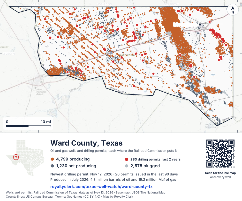
- Drilling locations283Permits issued in the last two years
- Producing wells4,799On a lease reporting production now
- Not producing1,230Shut in, inactive or no lease on record
- Plugged2,578The state's wellbore record says plugged
Sources: Railroad Commission of Texas well layers and permit files, US Census Bureau county outline, town points from GeoNames (CC BY 4.0), base map from USGS The National Map. A dot is a surface location; a horizontal well runs a mile or more from it.
8,607 wells with a location on the state's map (4,799 producing, 1,230 not producing, 2,578 plugged) and 283 drilling locations permitted in the last 24 months, each where the Railroad Commission puts it.
Use this map on your site
You may show this map on any site, unchanged. Keep the credit line and its link to Royalty Clerk under the map. The picture updates by itself as the state records new wells and permits.
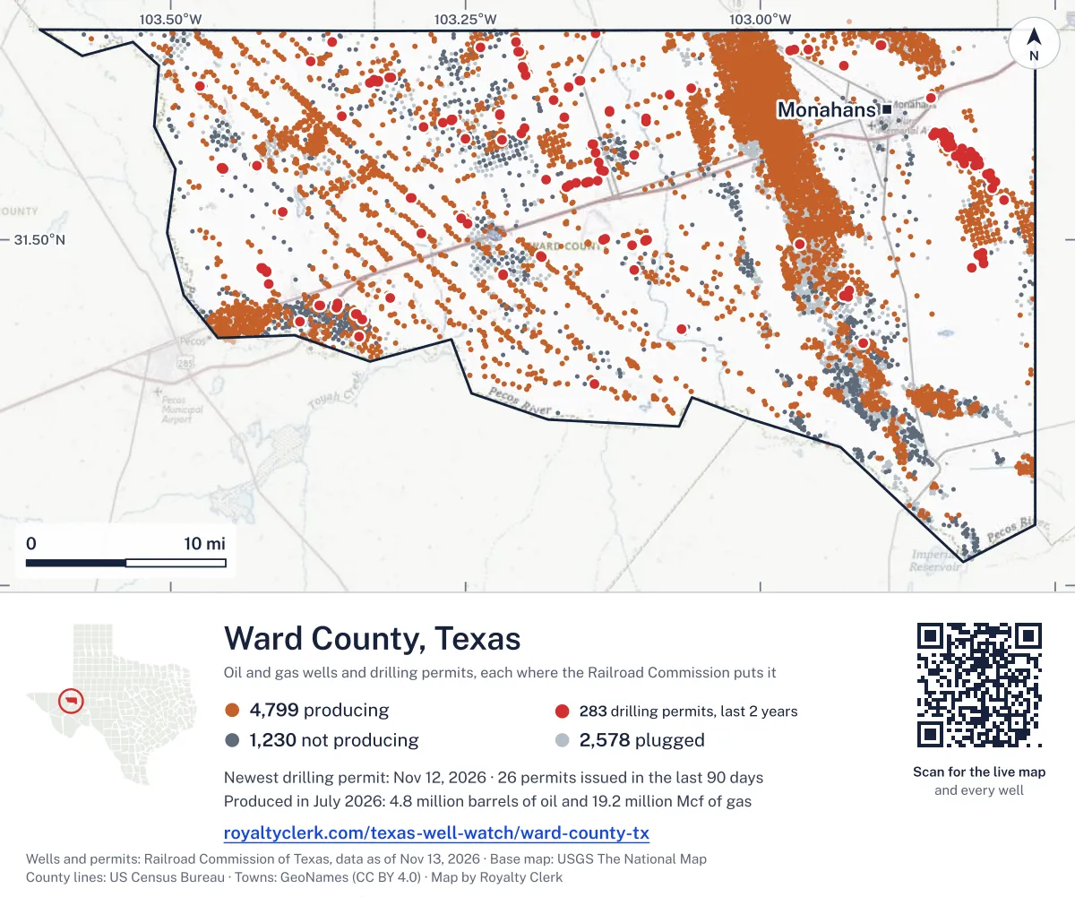
<a href="https://royaltyclerk.com/texas/counties/ward-county-tx"><img src="https://royaltyclerk.com/maps/county-wells/ward-county-tx.svg" alt="Map of Ward County, Texas, with 8,607 oil and gas wells and 283 recent drilling locations as dots." width="1000" height="834" loading="lazy" style="max-width:100%;height:auto;border:0"></a>
<p style="margin:4px 0 0;font-size:14px">Map: <a href="https://royaltyclerk.com/texas/counties/ward-county-tx">Ward County, Texas oil and gas wells</a> by Royalty Clerk, from Railroad Commission of Texas records</p>
Wells near a town: Monahans · Newest drilling permits in Ward County · Wells by ZIP code
Ward County reported 64 million barrels of oil and 233 million mcf of gas in the last 12 months. That ranks 10th of 225 Texas counties by oil.
County dossier
August 2026 is still coming in. About 89% of Texas leases have reported it so far, so this page counts through July 2026 until it is fully reported.
- Producing leases
- 1,660of 2,468 on record
- Operators
- 88
- Fields
- 111
- Top operator
- Crescent Energy Operating, LLC
Own minerals in Ward County?
A family member owned minerals here?
Search their name: a family member who owned minerals hereWhere it sits
This county
- Gas, last 12 months
- 232,903,351 mcf
- Share of Texas oil
- 3.1%
- Wells on record
- 8,631on leases with production reports
- Data through
- Jul 2026
Five years of output in Ward County
Oil output in Ward County held steady over the last 12 months
64M bbl through Jul 2026, against 63M bbl a year earlier. Peak Oct 2025: 6.2M bbl.
Gas output in Ward County rose 13% over the last 12 months
233M mcf through Jul 2026, against 206M mcf a year earlier. Peak Dec 2025: 22M mcf.
SourceTexas Railroad Commission Production Data Query, county totals, through Jul 2026, file dated Oct 20, 2026.
Cite or embed this chart
Free to use for Ward County, Texas, with a credit and a link. Copy what you need.
Credit line
Source: Royalty Clerk analysis of Texas Railroad Commission filings, https://royaltyclerk.com/texas/counties/ward-county-tx, data to July 2026.
The chart on your own page
Free to embed on any site. Keep the “Source: Royalty Clerk” link under the chart.
See the code
<iframe
  src="https://royaltyclerk.com/embed/counties/ward-county-tx"
  title="Royalty Clerk: oil and gas production, Ward County, Texas"
  width="100%"
  height="400"
  style="border:0"
  loading="lazy"></iframe>
<p style="margin:4px 0 0;font-size:14px">Source: <a href="https://royaltyclerk.com/texas/counties/ward-county-tx" target="_blank">Royalty Clerk</a></p>
<script>
window.addEventListener("message", function (e) {
  if (e.origin !== "https://royaltyclerk.com" || !e.data || e.data.type !== "rc-embed-height") return;
  var frames = document.getElementsByTagName("iframe");
  for (var i = 0; i < frames.length; i++) {
    if (frames[i].contentWindow === e.source && e.data.height > 0) frames[i].style.height = Number(e.data.height) + "px";
  }
});
</script>
Ward County oil and gas production by year, 1993 to 2025
Every full year we hold, 1993 to 2025. The highest year for oil since 1993 was 2024, at 65,014,478 bbl. The highest year for gas was 2025, at 218,698,696 mcf.
| Year | Oilbbl | Gasmcf |
|---|---|---|
| 2025 | 64,844,738 | 218,698,696 |
| 2024 | 65,014,478 | 203,564,283 |
| 2023 | 57,757,404 | 183,587,160 |
| 2022 | 51,772,846 | 166,089,839 |
| 2021 | 51,811,908 | 158,714,753 |
| 2020 | 51,376,923 | 147,204,048 |
| 2019 | 52,897,808 | 134,421,934 |
| 2018 | 38,202,305 | 92,501,728 |
| 2017 | 25,562,142 | 69,429,162 |
| 2016 | 22,592,700 | 66,075,925 |
| 2015 | 24,725,474 | 66,799,089 |
| 2014 | 25,154,863 | 67,631,213 |
| 2013 | 23,650,025 | 62,317,365 |
| 2012 | 20,387,592 | 61,232,569 |
| 2011 | 14,610,882 | 52,654,238 |
| 2010 | 11,044,338 | 48,666,416 |
| 2009 | 9,386,697 | 47,478,789 |
| 2008 | 8,134,298 | 49,229,705 |
| 2007 | 6,399,563 | 48,232,564 |
| 2006 | 6,134,688 | 50,145,395 |
| 2005 | 5,070,257 | 50,436,483 |
| 2004 | 4,682,195 | 55,657,465 |
| 2003 | 4,938,655 | 65,473,503 |
| 2002 | 5,293,015 | 71,975,720 |
| 2001 | 5,777,064 | 72,814,529 |
| 2000 | 6,234,474 | 64,276,810 |
| 1999 | 6,484,458 | 53,322,148 |
| 1998 | 7,842,664 | 57,984,158 |
| 1997 | 7,464,254 | 64,604,382 |
| 1996 | 6,559,275 | 65,026,671 |
| 1995 | 6,191,381 | 66,629,965 |
| 1994 | 6,512,243 | 68,742,888 |
| 1993 | 7,153,749 | 72,666,173 |
SourceTexas Railroad Commission production records, added up by county and calendar year. Oil includes condensate; gas includes casinghead gas. The year in progress is left out until it is complete.
Ward County appraisal district, 2026 mineral roll
Mineral owners in Ward County: 68,900 royalty records on the roll
At least 748 of the 68,900 royalty-interest records on Ward County's 2026 mineral roll are still titled to an estate (1.09%). We publish counts only. No owner’s name or address is on this page; to look for one family, search its name.
- Royalty-interest records, 2026 roll
- 68,900
- Still titled to an estate, at least
- 748
- Share of the roll
- 1.09%
SourceRoyalty Clerk count of the Ward County mineral appraisal roll of 2026, read November 2026. A record is one line of the roll, not one person.
The biggest leases in Ward County
Under each volume: change on the year before.
1,154,877bbl oil+8%
928,780bbl oil+264%
497,873bbl oil−11%
456,479bbl oiln/a
451,920bbl oil−35%
419,534bbl oil−16%
416,602bbl oiln/a
405,006bbl oil−11%
387,091bbl oil−20%
333,025bbl oiln/a
331,062bbl oiln/a
327,573bbl oiln/a
- UTL 2806A
325,114bbl oiln/a
- WHITE WING 14-1 UNIT
322,900bbl oiln/a
322,299bbl oiln/a
287,465bbl oiln/a
283,939bbl oiln/a
280,932bbl oiln/a
6,532,444mcf gasn/a
279,815bbl oiln/a
262,675bbl oiln/a
258,950bbl oil−14%
256,826bbl oiln/a
256,762bbl oil−35%
250,052bbl oil+152%
Showing 25 of 150 (the 150 largest of 1,660), ranked by output value.
SourceTexas Railroad Commission Production Data Query.
Who runs the leases, and what they produce
Operators in Ward County, by oil
Apache leads
- Apache Corporation231 leases9.6Mbbl
- Crescent Energy Operating, LLC150 leases9.5Mbbl
- Continental Resources, Inc.106 leases7.7Mbbl
- Jagged Peak Energy LLC66 leases4.5Mbbl
- Bosque Texas Oil LLC22 leases3.5Mbbl
- Diamondback E&P LLC88 leases3.4Mbbl
- Jetta Operating Company, Inc.92 leases2.8Mbbl
- Anadarko E&P Onshore LLC110 leases2.5Mbbl
Fields in Ward County, by oil
Phantom (Wolfcamp) leads
- Phantom (Wolfcamp)971 leases · District 08 · Field 7105290048Mbbl
- Ruppel (Woodford)32 leases · District 08 · Field 789538005.8Mbbl
- Two Georges (Bone Spring)48 leases · District 08 · Field 921000502.1Mbbl
- Collie (Delaware)47 leases · District 08 · Field 196652001.7Mbbl
- Wolfbone (Trend Area)19 leases · District 08 · Field 98359800915kbbl
- Ward-Estes, North34 leases · District 08 · Field 95152001889kbbl
- Sandbar (Bone Spring)57 leases · District 08 · Field 80544500844kbbl
- Hoefs T-K (Wolfcamp)19 leases · District 08 · Field 41911500679kbbl
More operators here
Recent drilling permits in Ward County
VULCAN 2-3 H #303HR
new drill · horizontal · MCM Operating, LLC · Ward County
Permit 0920106 · Nov 12, 2026
EAGER BEAVER 58/47 A #F101DA
new drill · horizontal · Mewbourne Oil Company · Ward County
Permit 0919831 · Nov 2, 2026
ALL AMERICAN 57/48 A #F101MP
new drill · horizontal · Mewbourne Oil Company · Ward County
Permit 0919832 · Nov 2, 2026
SEALY RANCH #5603H
new drill · horizontal · Halcon Operating Co., Inc. · Ward County
Permit 0919821 · Oct 30, 2026
SEALY RANCH #5602H
new drill · horizontal · Halcon Operating Co., Inc. · Ward County
Permit 0919820 · Oct 30, 2026
SWOOSE 84/82 B #F101BG
new drill · horizontal · Mewbourne Oil Company · Ward County
Permit 0919294 · Oct 16, 2026