
Yoakum County, Texas
Yoakum County drilling permits: what the state recorded
- 158drilling permits
- 166completions
- 7first-production reports
- in the last twelve months
Wells by coordinates
Oil wells and drilling locations in Yoakum County
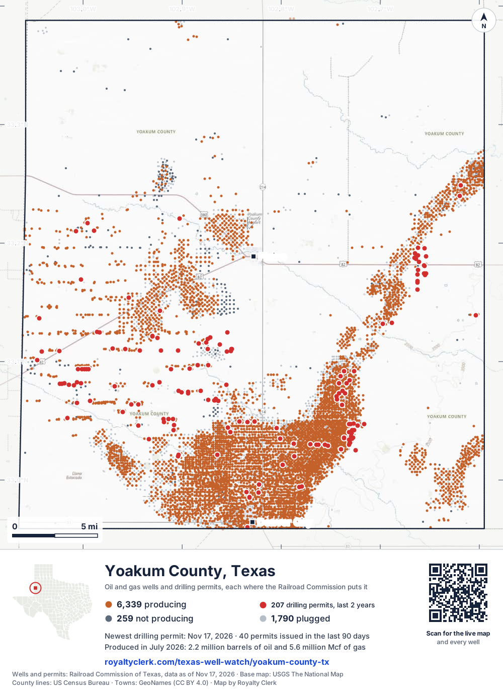
- Drilling locations207Permits issued in the last two years
- Producing wells6,339On a lease reporting production now
- Not producing259Shut in, inactive or no lease on record
- Plugged1,790The state's wellbore record says plugged
Sources: Railroad Commission of Texas well layers and permit files, US Census Bureau county outline, town points from GeoNames (CC BY 4.0), base map from USGS The National Map. A dot is a surface location; a horizontal well runs a mile or more from it.
8,388 wells with a location on the state's map and 207 drilling locations permitted in the last 24 months, each where the Railroad Commission puts it.
A permit is not a well.
Yoakum County is one of the 61 counties of the Permian Basin
Wells near each town in Yoakum County
Wells within 10 miles of each town, on either side of the county line.
Use this map on your site
You may show this map on any site, unchanged. Keep the credit line and its link to Royalty Clerk under the map. The picture updates by itself as the state records new wells and permits.
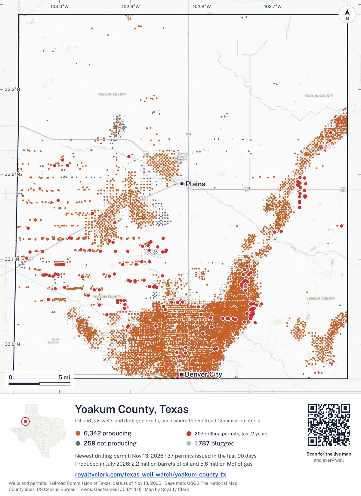
<a href="https://royaltyclerk.com/texas-well-watch/yoakum-county-tx"><img src="https://royaltyclerk.com/maps/county-wells/yoakum-county-tx.svg" alt="Map of Yoakum County, Texas, with 8,388 oil and gas wells and 207 recent drilling locations as dots." width="1000" height="1374" loading="lazy" style="max-width:100%;height:auto;border:0"></a>
<p style="margin:4px 0 0;font-size:14px">Map: <a href="https://royaltyclerk.com/texas-well-watch/yoakum-county-tx">Yoakum County, Texas oil and gas wells</a> by Royalty Clerk, from Railroad Commission of Texas records</p>
The last twelve months
Month by month in Yoakum County
| Month | Permits | Completions | First production |
|---|---|---|---|
| Nov 2026 | 11 | 0 | 0 |
| Oct 2026 | 10 | 1 | 0 |
| Sep 2026 | 17 | 2 | 0 |
| Aug 2026 | 22 | 8 | 2 |
| Jul 2026 | 13 | 15 | 0 |
| Jun 2026 | 3 | 11 | 0 |
| May 2026 | 8 | 16 | 1 |
| Apr 2026 | 12 | 22 | 1 |
| Mar 2026 | 23 | 18 | 0 |
| Feb 2026 | 5 | 23 | 2 |
| Jan 2026 | 27 | 17 | 1 |
| Dec 2025 | 7 | 29 | 0 |
| Nov 2025 | 0 | 4 | 0 |
Counted from November 19, 2025 to November 17, 2026, so the first and last months are partial. Source: Railroad Commission of Texas data sets.
Free, no sign-in
The newest drilling permits in Yoakum County
| Issued | Lease and well | Operator | Drilling began | Depth, ft | API number | Coordinates | Permit |
|---|---|---|---|---|---|---|---|
| 2026-11-17 | WEST SAN ANDRES UNIT 5758Hnew drill · horizontalRiley Permian Operating Co, LLCAPI 42-501-37751 · permit 09201179,000 ft | Riley Permian Operating Co, LLC | |||||
| 2026-11-17 | WEST SAN ANDRES UNIT 5757Hnew drill · horizontalRiley Permian Operating Co, LLCAPI 42-501-37749 · permit 09201099,000 ft | Riley Permian Operating Co, LLC | |||||
| 2026-11-17 | WEST SAN ANDRES UNIT 5753Hnew drill · horizontalRiley Permian Operating Co, LLCAPI 42-501-37750 · permit 09201159,000 ft | Riley Permian Operating Co, LLC | |||||
| 2026-11-17 | WEST SAN ANDRES UNIT 5751Hnew drill · horizontalRiley Permian Operating Co, LLCAPI 42-501-37748 · permit 09201089,000 ft | Riley Permian Operating Co, LLC | |||||
| 2026-11-13 | RUSTY CRANE 604 5Hnew drill · horizontalRiley Permian Operating Co, LLCAPI 42-501-37747 · permit 09200439,000 ft | Riley Permian Operating Co, LLC | |||||
| 2026-11-13 | RUSTY CRANE 604 4Hnew drill · horizontalRiley Permian Operating Co, LLCAPI 42-501-37746 · permit 09200429,000 ft | Riley Permian Operating Co, LLC | |||||
| 2026-11-13 | BENNETT RANCH UNIT 4368recompletion · horizontalOccidental Permian Ltd.API 42-501-35664 · permit 092005633.07546, -102.738245,700 ft | Occidental Permian Ltd. | |||||
| 2026-11-13 | BENNETT RANCH UNIT 4347recompletion · horizontalOccidental Permian Ltd.API 42-501-34865 · permit 092005833.07043, -102.743975,700 ft | Occidental Permian Ltd. | |||||
| 2026-11-13 | BENNETT RANCH UNIT 3421recompletion · horizontalOccidental Permian Ltd.API 42-501-36863 · permit 092004433.08431, -102.731035,700 ft | Occidental Permian Ltd. | |||||
| 2026-11-13 | BENNETT RANCH UNIT 3340recompletion · horizontalOccidental Permian Ltd.API 42-501-31023 · permit 092005533.08154, -102.741755,700 ft | Occidental Permian Ltd. | |||||
| 2026-11-05 | BRUCE GENTRY JR 598-647 E 14XHnew drill · horizontalRing Energy, Inc.API 42-501-37744 · permit 091954333.08116, -103.023456,050 ft | Ring Energy, Inc. | |||||
| 2026-10-30 | BRUCE GENTRY JR 598-647 D 13XHnew drill · horizontalRing Energy, Inc.API 42-501-37743 · permit 091952733.08125, -103.021396,050 ft | Ring Energy, Inc. | |||||
| 2026-10-30 | BOOMS FARM 710 - 727 B 2XHnew drill · horizontalRing Energy, Inc.API 42-501-37745 · permit 091975833.06503, -103.006255,500 ft | Ring Energy, Inc. | |||||
| 2026-10-27 | BRUCE GENTRY JR 598-647 CC 12XHnew drill · horizontalRing Energy, Inc.API 42-501-37742 · permit 091949133.08154, -103.018906,050 ft | Ring Energy, Inc. | |||||
| 2026-10-20 | JEREMIAH JOHNSON 667-706 3XHnew drill · horizontalRiley Permian Operating Co, LLCAPI 42-501-37741 · permit 091931933.08250, -102.923169,000 ft | Riley Permian Operating Co, LLC | |||||
| 2026-10-14 | CAT BALLOU 573-546 6XHnew drill · horizontalRiley Permian Operating Co, LLCAPI 42-501-37740 · permit 091921333.10894, -102.850789,000 ft | Riley Permian Operating Co, LLC | |||||
| 2026-10-08 | CASSIDY 575 1Wnew drill · verticalRiley Permian Operating Co, LLCAPI 42-501-37737 · permit 091906233.11913, -102.8741612,000 ft | Riley Permian Operating Co, LLC | |||||
| 2026-10-07 | GUS MCCRAE 671 1Wnew drill · verticalRiley Permian Operating Co, LLCAPI 42-501-37739 · permit 091918933.06860, -102.8661013,000 ft | Riley Permian Operating Co, LLC | |||||
| 2026-10-06 | HUCKLEBERRY-MCMASTERS 730-771 4XHnew drill · horizontalRiley Permian Operating Co, LLCAPI 42-501-37738 · permit 091902233.04584, -102.944189,000 ft | Riley Permian Operating Co, LLC | |||||
| 2026-10-06 | BENNETT RANCH UNIT 4352recompletion · horizontalOccidental Permian Ltd.API 42-501-34870 · permit 091904933.07304, -102.741515,650 ft | Occidental Permian Ltd. | |||||
| 2026-10-02 | FARQUAAD 5new drill · verticalTexland Petroleum, L.P.API 42-501-37736 · permit 091900733.17297, -102.654779,000 ft | Texland Petroleum, L.P. | |||||
| 2026-09-30 | HUCKLEBERRY-MCMASTERS 730-771 5XHnew drill · horizontalRiley Permian Operating Co, LLCAPI 42-501-37735 · permit 091893833.04592, -102.944199,000 ft | Riley Permian Operating Co, LLC | |||||
| 2026-09-28 | SUNDANCE 642 5Hnew drill · horizontalRiley Permian Operating Co, LLCAPI 42-501-37734 · permit 091889533.07992, -102.929909,000 ft | Riley Permian Operating Co, LLC | |||||
| 2026-09-28 | BEATEN PATH 597-648 35XHnew drill · horizontalRiley Permian Operating Co, LLCAPI 42-501-37732 · permit 091883233.10867, -103.041639,000 ft | Riley Permian Operating Co, LLC | |||||
| 2026-09-25 | SUNDANCE 642 4Hnew drill · horizontalRiley Permian Operating Co, LLCAPI 42-501-37733 · permit 091889633.08001, -102.929909,000 ft | Riley Permian Operating Co, LLC | |||||
| 2026-09-25 | CASSIDY 575-544 E 3XHnew drill · horizontalRiley Permian Operating Co, LLCAPI 42-501-37730 · permit 091881433.11621, -102.875749,000 ft | Riley Permian Operating Co, LLC | |||||
| 2026-09-25 | BEATEN PATH 597-648 15XHnew drill · horizontalRiley Permian Operating Co, LLCAPI 42-501-37731 · permit 091883133.10891, -103.024179,000 ft | Riley Permian Operating Co, LLC | |||||
| 2026-09-21 | WEST BRAHANEY UNIT 180recompletion · verticalBurk Royalty Co., Ltd.API 42-501-34479 · permit 091870033.14276, -102.922435,600 ft | Burk Royalty Co., Ltd. | |||||
| 2026-09-18 | JEREMIAH JOHNSON 667-706 2XHnew drill · horizontalRiley Permian Operating Co, LLCAPI 42-501-37728 · permit 091866633.08242, -102.923169,000 ft | Riley Permian Operating Co, LLC | |||||
| 2026-09-18 | JEREMIAH JOHNSON 667-706 1XHnew drill · horizontalRiley Permian Operating Co, LLCAPI 42-501-37729 · permit 091867033.08235, -102.923169,000 ft | Riley Permian Operating Co, LLC | |||||
| 2026-09-17 | DONKEY 2new drill · verticalTexland Petroleum, L.P.API 42-501-37727 · permit 091863733.18865, -102.653929,000 ft | Texland Petroleum, L.P. | |||||
| 2026-09-16 | HOOKER, L.H. 11new drill · verticalTexland Petroleum, L.P.API 42-501-37726 · permit 091863133.19547, -102.655309,000 ft | Texland Petroleum, L.P. | |||||
| 2026-09-14 | WEST BRAHANEY UNIT 223recompletion · verticalBurk Royalty Co., Ltd.API 42-501-35551 · permit 091848633.11992, -102.924915,500 ft | Burk Royalty Co., Ltd. | |||||
| 2026-09-02 | BENNETT RANCH UNIT 4368recompletion · horizontalOccidental Permian Ltd.API 42-501-35664 · permit 091824533.07546, -102.738245,650 ft | Occidental Permian Ltd. | |||||
| 2026-09-02 | BENNETT RANCH UNIT 3343recompletion · horizontalOccidental Permian Ltd.API 42-501-31026 · permit 091823833.08161, -102.734085,675 ft | Occidental Permian Ltd. | |||||
| 2026-09-01 | BENNETT RANCH UNIT 4370recompletion · horizontalOccidental Permian Ltd.API 42-501-35666 · permit 091822433.07305, -102.735465,700 ft | Occidental Permian Ltd. | |||||
| 2026-09-01 | BENNETT RANCH UNIT 3322recompletion · horizontalOccidental Permian Ltd.API 42-501-31086 · permit 091823933.08773, -102.740035,700 ft | Occidental Permian Ltd. | |||||
| 2026-09-01 | BENNETT RANCH UNIT 3310recompletion · horizontalOccidental Permian Ltd.API 42-501-31082 · permit 091823633.09172, -102.736345,700 ft | Occidental Permian Ltd. | |||||
| 2026-08-26 | GRANGER 1new drill · verticalTexland Petroleum, L.P.API 42-501-37725 · permit 091808733.13271, -102.688139,000 ft | Texland Petroleum, L.P. | |||||
| 2026-08-26 | LOVEGOOD 1new drill · verticalTexland Petroleum, L.P.API 42-501-37724 · permit 091808533.16066, -102.662589,000 ft | Texland Petroleum, L.P. | |||||
| 2026-08-20 | BOOMS FARM 710 - 727 1XHnew drill · horizontalRing Energy, Inc.API 42-501-37723 · permit 091788133.06669, -102.993175,500 ft | Ring Energy, Inc. | |||||
| 2026-08-17 | WILLARD UNIT 156 Arecompletion · horizontalOXY USA WTP LPAPI 42-501-30805 · permit 091784133.04410, -102.853965,448 ft | OXY USA WTP LP | |||||
| 2026-08-17 | WILLARD UNIT 140 Crecompletion · horizontalOXY USA WTP LPAPI 42-501-31512 · permit 091784033.04066, -102.851365,533 ft | OXY USA WTP LP | |||||
| 2026-08-14 | YOAKUM WASSON CLEARFORK UNIT 8653Hnew drill · horizontalOccidental Permian Ltd.API 42-501-37721 · permit 091778732.99629, -102.822376,050 ft | Occidental Permian Ltd. | |||||
| 2026-08-14 | WASSON ODC UNIT 919Hnew drill · horizontalOccidental Permian Ltd.API 42-501-37718 · permit 091778033.02604, -102.739395,500 ft | Occidental Permian Ltd. | |||||
| 2026-08-14 | CLEVELAND A 601 5Hnew drill · horizontalRiley Permian Operating Co, LLCAPI 42-501-37715 · permit 091777833.11074, -102.957469,000 ft | Riley Permian Operating Co, LLC | |||||
| 2026-08-13 | CLEVELAND A 601 35Hnew drill · horizontalRiley Permian Operating Co, LLCAPI 42-501-37716 · permit 091781733.11091, -102.970069,000 ft | Riley Permian Operating Co, LLC | |||||
| 2026-08-13 | YOAKUM WASSON CLEARFORK UNIT 8654Hnew drill · horizontalOccidental Permian Ltd.API 42-501-37722 · permit 091778932.99629, -102.822266,050 ft | Occidental Permian Ltd. | |||||
| 2026-08-13 | WASSON ODC UNIT 595recompletion · horizontalOccidental Permian Ltd.API 42-501-32564 · permit 091778433.01287, -102.798615,500 ft | Occidental Permian Ltd. | |||||
| 2026-08-13 | WASSON ODC UNIT 921Hnew drill · horizontalOccidental Permian Ltd.API 42-501-37720 · permit 091777733.02585, -102.739395,500 ft | Occidental Permian Ltd. |
These are the newest 50 of 313 permits on file for Yoakum County. The rest follow, 50 to a page.
A permit is permission to drill, not a well. Source: Railroad Commission of Texas drilling permit files.
Year by year
Drilling permits issued in Yoakum County, by year
| Year | Permits issued |
|---|---|
| 2026 so far | 151 |
| 2025 | 50 |
| 2024 | 81 |
| 2023 | 29 |
| 2022 | 1 |
| 2008 | 1 |
Counted from the permit files we hold, which start in 2008; that first year may be partial. Source: Railroad Commission of Texas drilling permit files.
The latest
The most recent records
| Date | What, who and where |
|---|---|
| 2026-11-17 | Permit issued: Riley Permian Operating Co, LLCWEST SAN ANDRES UNIT · A-571 · permit 0920117 |
| 2026-11-17 | Permit issued: Riley Permian Operating Co, LLCWEST SAN ANDRES UNIT · A-571 · permit 0920109 |
| 2026-11-17 | Permit issued: Riley Permian Operating Co, LLCWEST SAN ANDRES UNIT · A-571 · permit 0920115 |
| 2026-11-17 | Permit issued: Riley Permian Operating Co, LLCWEST SAN ANDRES UNIT · A-571 · permit 0920108 |
| 2026-11-13 | Permit issued: Occidental Permian Ltd.BENNETT RANCH UNIT · A-550 · permit 0920044 |
| 2026-11-13 | Permit issued: Occidental Permian Ltd.BENNETT RANCH UNIT · A-472 · permit 0920056 |
| 2026-11-13 | Permit issued: Occidental Permian Ltd.BENNETT RANCH UNIT · A-553 · permit 0920055 |
| 2026-11-13 | Permit issued: Occidental Permian Ltd.BENNETT RANCH UNIT · A-472 · permit 0920058 |
| 2026-11-13 | Permit issued: Riley Permian Operating Co, LLCRUSTY CRANE 604 · A-529 · permit 0920043 |
| 2026-11-13 | Permit issued: Riley Permian Operating Co, LLCRUSTY CRANE 604 · A-529 · permit 0920042 |
| 2026-11-05 | Permit issued: Ring Energy, Inc.BRUCE GENTRY JR 598-647 E · A-557 · permit 0919543 |
| 2026-10-30 | Permit issued: Ring Energy, Inc.BRUCE GENTRY JR 598-647 D · A-557 · permit 0919527 |
| 2026-10-30 | Permit issued: Ring Energy, Inc.BOOMS FARM 710 - 727 B · A-1065 · permit 0919758 |
| 2026-10-27 | Permit issued: Ring Energy, Inc.BRUCE GENTRY JR 598-647 CC · A-557 · permit 0919491 |
| 2026-10-20 | Permit issued: Riley Permian Operating Co, LLCJEREMIAH JOHNSON 667-706 · A-1490 · permit 0919319 |
Coming up
First checks coming due in Yoakum County
- WILLARD UNIT, OXY USA WTP LPby November 28, 2026
- WILLARD UNIT, OXY USA WTP LPby November 28, 2026
- WILLARD UNIT, OXY USA WTP LPby November 28, 2026
- WILLARD UNIT, OXY USA WTP LPby November 28, 2026
- DENVER UNIT, Occidental Permian Ltd.by November 28, 2026
- CORNELL UNIT, Hilcorp Energy Companyby November 28, 2026
- ROBERTS UNIT, Hilcorp Energy Companyby November 28, 2026
- BENNETT RANCH UNIT, Occidental Permian Ltd.by November 28, 2026
- WASSON ODC UNIT, Occidental Permian Ltd.by December 29, 2026
- WILLARD UNIT, OXY USA WTP LPby December 29, 2026
Follow it
Watch Yoakum County, or one abstract
What do you want to follow?
Where the land is. Your deed or lease names it.
For example A-1119, or Bush, or T&P 38. Your deed or the tax bill has it.
Other counties
Drilling activity in other counties
Related
Related
- ToolTexas well watchPermit, completion, first production and when the first check is due.
- ToolIs this buyout offer fair?The offer as months of your income, what the acres mean, and the questions to ask.
- ToolIs this lease offer good?Bonus and royalty against the county, and a scan of the lease's clauses.
- Texas dataTexas operator changesWho took over whose leases in the last 24 months.
- ToolLate payment interestDeadlines and the interest a late payment earns.
- Texas dataTexas oil and gas atlas254 counties, every lease, operator and field.
FAQ
Questions people ask
How many wells were permitted in Yoakum County in the last year?
The Railroad Commission issued 158 drilling permits in Yoakum County in the twelve months to November 17, 2026, and recorded 166 completions and 7 first-production reports. A permit is permission to drill, not a well.
How do I get an alert when a permit is issued near my land in Yoakum County?
Choose your abstract on this page, or the whole county, and sign in. You get one email a week, only when something new is recorded after you sign up. The alert says whether an event is on an interest in your Mineral File, on a place you follow, or only nearby.
When is my first royalty check due after a new well?
Natural Resources Code section 91.402(a) says on or before 120 days after the end of the month of first sale of production from the well. The state's first-production month is the closest public marker, so the date on this page is the earliest, not a certainty.
Got a new well on your land?
The first check is due within 120 days after the end of the month of first sale.
Sources
Primary sources, opened on 29 September 2026. Statute text is the current version on statutes.capitol.texas.gov.