
Yoakum County, Texas
Oil wells and drilling locations near Plains
- 2,504wells
- 97drilling locations in two years
- 217producing leases
Within 10 miles
Wells and drilling locations around Plains
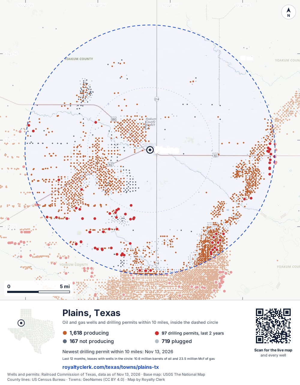
- Drilling locations97Permits issued in the last two years
- Producing wells1,618On a lease reporting production now
- Not producing167Shut in, inactive or no lease on record
- Plugged719The state's wellbore record says plugged
The dashed circle is 10 miles from the town's point (33.18871, -102.82799); the counts are for wells inside it. Sources: Railroad Commission of Texas well layers and permit files, US Census Bureau county outlines, town points from GeoNames (CC BY 4.0), base map from USGS The National Map.
Use this map on your site
You may show this map on any site, unchanged. Keep the credit line and its link to Royalty Clerk under the map. The picture updates by itself as the state records new wells and permits.
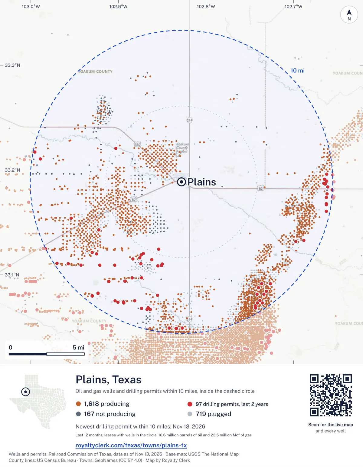
<a href="https://royaltyclerk.com/texas/towns/plains-tx"><img src="https://royaltyclerk.com/maps/town-wells/plains-tx.svg" alt="Map of Plains, Texas: 2,504 wells and 97 recent drilling locations within 10 miles, inside a dashed circle." width="1000" height="1284" loading="lazy" style="max-width:100%;height:auto;border:0"></a>
<p style="margin:4px 0 0;font-size:14px">Map: <a href="https://royaltyclerk.com/texas/towns/plains-tx">Plains, Texas oil and gas wells</a> by Royalty Clerk, from Railroad Commission of Texas records</p>
Which way it is heading
Where the new drilling is around Plains
What became of the 97 permits
- 24finished, on a lease that reports productionThe well was completed and its lease is reporting oil or gas to the state.
- 20drilling startedThe operator reported a start date. No completion is on file yet.
- 53still only a permitNothing after the permit is on file. Many permits wait a year or more, and some are never drilled.
Wells finished in the last two years: 4 east, 1 south-east, 11 south, 17 south-west, 1 north-west of town.
A horizontal well runs sideways underground. 29 wells start outside the 10-mile circle and end inside it. 28 start inside and end outside. So a well can drain land a mile or two from the spot where it shows on a map.
A permit is permission to drill, not a well, and a well nearby says nothing about who owns the minerals under it. Direction is taken from the well's surface location. Source: Railroad Commission of Texas drilling permits and wellbore records.
When a new well starts paying
First checks coming due near Plains
- Bennett Ranch Unit well 4319Wwas due October 28, 2026
- Willard Unit well 29Wdue by November 28, 2026
- Willard Unit well 179AWdue by November 28, 2026
- Willard Unit well 33AWdue by November 28, 2026
- Willard Unit well 40Adue by November 28, 2026
- Bennett Ranch Unit well 4304RWdue by November 28, 2026
- Wasson Odc Unit well 50due by December 29, 2026
- Willard Unit well 37AWdue by December 29, 2026
- Wasson Odc Unit well 284due by December 29, 2026
- Wasson Odc Unit well 314due by December 29, 2026
The date is the earliest the law allows a first payment to be late (Texas Natural Resources Code 91.402), worked out from the first month of production on file. It is not a promise of a check: title questions and unsigned division orders can hold one back. Work out a first-check date · What to do before the first check
In numbers
Oil and gas within 10 miles of Plains
- wells with a location on the state's map
- 2,504
- drilling permits in the last 24 months
- 97
- producing leases with a well in the circle
- 217
- operators running them
- 39
- oil and condensate those leases reported in their latest 12 months
- 10,590,773 bbl
- gas those leases reported in their latest 12 months
- 23,495,509 mcf
A lease counts when at least one of its wells is inside the circle; its whole production is counted, so a lease reaching beyond the circle counts in full.
In dollars
What the oil and gas near Plains sold for
- sale value of 12 months, before taxes and costs
- $888 million
- oil and condensate sold
- 10,570,873 bbl
- gas sold
- 21,867,402 mcf
- the middle lease: half sold more, half less
- $591,602
A 0.01 share (1%) of the middle producing lease near Plains comes to about $5,916 for the 12 months.
Sold volumes at the public monthly prices, before severance tax and any costs. A guide to the size, not what any owner was paid.
Sold volumes from each lease's monthly report to the Railroad Commission, times the month's West Texas Intermediate oil price and Henry Hub gas price (EIA). Real prices at the lease differ. A lease counts in full when one of its wells is near the town. Check a statement against what the lease sold
Drilling locations
The newest drilling permits near Plains
| Issued | Lease and well | Where | Operator |
|---|---|---|---|
| 2026-11-13 | BENNETT RANCH UNIT 4368horizontal · API 42-501-35664 · permit 0920056Occidental Permian Ltd. | 9.4 mi SE33.07546, -102.73824 on OpenStreetMap (opens in a new tab) | Occidental Permian Ltd. |
| 2026-11-13 | BENNETT RANCH UNIT 4347horizontal · API 42-501-34865 · permit 0920058Occidental Permian Ltd. | 9.5 mi SE33.07043, -102.74397 on OpenStreetMap (opens in a new tab) | Occidental Permian Ltd. |
| 2026-11-13 | BENNETT RANCH UNIT 3421horizontal · API 42-501-36863 · permit 0920044Occidental Permian Ltd. | 9.1 mi SE33.08431, -102.73103 on OpenStreetMap (opens in a new tab) | Occidental Permian Ltd. |
| 2026-11-13 | BENNETT RANCH UNIT 3340horizontal · API 42-501-31023 · permit 0920055Occidental Permian Ltd. | 8.9 mi SE33.08154, -102.74175 on OpenStreetMap (opens in a new tab) | Occidental Permian Ltd. |
| 2026-10-20 | JEREMIAH JOHNSON 667-706 3XHhorizontal · API 42-501-37741 · permit 0919319Riley Permian Operating Co, LLC | 9.2 mi SW33.08250, -102.92316 on OpenStreetMap (opens in a new tab) | Riley Permian Operating Co, LLC |
| 2026-10-14 | CAT BALLOU 573-546 6XHhorizontal · API 42-501-37740 · permit 0919213Riley Permian Operating Co, LLC | 5.7 mi S33.10894, -102.85078 on OpenStreetMap (opens in a new tab) | Riley Permian Operating Co, LLC |
| 2026-10-08 | CASSIDY 575 1Wvertical · API 42-501-37737 · permit 0919062Riley Permian Operating Co, LLC | 5.5 mi SW33.11913, -102.87416 on OpenStreetMap (opens in a new tab) | Riley Permian Operating Co, LLC |
| 2026-10-07 | GUS MCCRAE 671 1Wvertical · API 42-501-37739 · permit 0919189Riley Permian Operating Co, LLC | 8.6 mi S33.06860, -102.86610 on OpenStreetMap (opens in a new tab) | Riley Permian Operating Co, LLC |
| 2026-10-06 | BENNETT RANCH UNIT 4352horizontal · API 42-501-34870 · permit 0919049Occidental Permian Ltd. | 9.4 mi SE33.07304, -102.74151 on OpenStreetMap (opens in a new tab) | Occidental Permian Ltd. |
| 2026-09-28 | SUNDANCE 642 5Hhorizontal · API 42-501-37734 · permit 0918895Riley Permian Operating Co, LLC | 9.5 mi SW33.07992, -102.92990 on OpenStreetMap (opens in a new tab) | Riley Permian Operating Co, LLC |
| 2026-09-25 | SUNDANCE 642 4Hhorizontal · API 42-501-37733 · permit 0918896Riley Permian Operating Co, LLC | 9.5 mi SW33.08001, -102.92990 on OpenStreetMap (opens in a new tab) | Riley Permian Operating Co, LLC |
| 2026-09-25 | CASSIDY 575-544 E 3XHhorizontal · API 42-501-37730 · permit 0918814Riley Permian Operating Co, LLC | 5.7 mi SW33.11621, -102.87574 on OpenStreetMap (opens in a new tab) | Riley Permian Operating Co, LLC |
| 2026-09-21 | WEST BRAHANEY UNIT 180vertical · API 42-501-34479 · permit 0918700Burk Royalty Co., Ltd. | 6.3 mi SW33.14276, -102.92243 on OpenStreetMap (opens in a new tab) | Burk Royalty Co., Ltd. |
| 2026-09-18 | JEREMIAH JOHNSON 667-706 2XHhorizontal · API 42-501-37728 · permit 0918666Riley Permian Operating Co, LLC | 9.2 mi SW33.08242, -102.92316 on OpenStreetMap (opens in a new tab) | Riley Permian Operating Co, LLC |
| 2026-09-18 | JEREMIAH JOHNSON 667-706 1XHhorizontal · API 42-501-37729 · permit 0918670Riley Permian Operating Co, LLC | 9.2 mi SW33.08235, -102.92316 on OpenStreetMap (opens in a new tab) | Riley Permian Operating Co, LLC |
| 2026-09-14 | WEST BRAHANEY UNIT 223vertical · API 42-501-35551 · permit 0918486Burk Royalty Co., Ltd. | 7.4 mi SW33.11992, -102.92491 on OpenStreetMap (opens in a new tab) | Burk Royalty Co., Ltd. |
| 2026-09-02 | BENNETT RANCH UNIT 4368horizontal · API 42-501-35664 · permit 0918245Occidental Permian Ltd. | 9.4 mi SE33.07546, -102.73824 on OpenStreetMap (opens in a new tab) | Occidental Permian Ltd. |
| 2026-09-02 | BENNETT RANCH UNIT 3343horizontal · API 42-501-31026 · permit 0918238Occidental Permian Ltd. | 9.2 mi SE33.08161, -102.73408 on OpenStreetMap (opens in a new tab) | Occidental Permian Ltd. |
| 2026-09-01 | BENNETT RANCH UNIT 4370horizontal · API 42-501-35666 · permit 0918224Occidental Permian Ltd. | 9.6 mi SE33.07305, -102.73546 on OpenStreetMap (opens in a new tab) | Occidental Permian Ltd. |
| 2026-09-01 | BENNETT RANCH UNIT 3322horizontal · API 42-501-31086 · permit 0918239Occidental Permian Ltd. | 8.6 mi SE33.08773, -102.74003 on OpenStreetMap (opens in a new tab) | Occidental Permian Ltd. |
| 2026-09-01 | BENNETT RANCH UNIT 3310horizontal · API 42-501-31082 · permit 0918236Occidental Permian Ltd. | 8.5 mi SE33.09172, -102.73634 on OpenStreetMap (opens in a new tab) | Occidental Permian Ltd. |
| 2026-08-26 | GRANGER 1vertical · API 42-501-37725 · permit 0918087Texland Petroleum, L.P. | 9.0 mi SE33.13271, -102.68813 on OpenStreetMap (opens in a new tab) | Texland Petroleum, L.P. |
| 2026-08-26 | LOVEGOOD 1vertical · API 42-501-37724 · permit 0918085Texland Petroleum, L.P. | 9.8 mi E33.16066, -102.66258 on OpenStreetMap (opens in a new tab) | Texland Petroleum, L.P. |
| 2026-08-14 | CLEVELAND A 601 5Hhorizontal · API 42-501-37715 · permit 0917778Riley Permian Operating Co, LLC | 9.2 mi SW33.11074, -102.95746 on OpenStreetMap (opens in a new tab) | Riley Permian Operating Co, LLC |
| 2026-08-13 | CLEVELAND A 601 35Hhorizontal · API 42-501-37716 · permit 0917817Riley Permian Operating Co, LLC | 9.8 mi SW33.11091, -102.97006 on OpenStreetMap (opens in a new tab) | Riley Permian Operating Co, LLC |
A permit is permission to drill, not a well. Distances are from the town's point to the well's surface location. Source: Railroad Commission of Texas drilling permits.
Find your land
The surveys under the new drilling near Plains
- A-571 PEAK, S, block D, section 5757 permits, newest October 8, 2026
- A-472 MASON, J E, block D, section 6786 permits, newest November 13, 2026
- A-406 GIBSON, J H, block D, section 56 permits, newest August 12, 2026
- A-544 KINGSTON, J, block D, section 6696 permits, newest September 16, 2025
- A-572 PEAK, S, block D, section 6715 permits, newest October 7, 2026
- A-553 MASON, P H, block D, section 6314 permits, newest November 13, 2026
- A-1259 YATES, T B, block D, section 44 permits, newest August 4, 2026
- A-1143 FITZGERALD, H, block D, section 6704 permits, newest February 17, 2026
Not in the list? Search every survey in the county by name or abstract number.
Who is on the county roll
735 mineral accounts near Plains are still in the name of an estate
- mineral accounts on the roll
- 45,576
- owner names
- 6,950
- appraised value of those accounts
- $931 million
- the middle account's appraised value
- $272
- the middle account in all of Yoakum County
- $413
- accounts titled to an estate
- 735
An account in the name of an estate usually means the owner died and the title was never moved to the heirs. The account stays on the roll, and these are appraised at $3.0 million together. If a parent or grandparent owned minerals near Plains, their name may be one of them.
Totals from the county appraisal district's mineral roll, matched to leases by the state lease number. No owner is named here, and a count under 10 accounts or 5 owner names is left out. How Yoakum County values minerals, and how to protest · Inherited minerals: where to start
Producing leases
Top producing leases near Plains
- 1Wasson Odc Unit1,861,136 bbl · 3,033,070 mcf a yearOccidental Permian Ltd. · Yoakum County · 19 wells in the circle
- 2Willard Unit1,562,491 bbl · 2,473,797 mcf a yearOXY USA WTP LP · Yoakum County · 225 wells in the circle
- 3Bennett Ranch Unit1,291,908 bbl · 1,101,712 mcf a yearOccidental Permian Ltd. · Yoakum County · 468 wells in the circle
- 4Hoss 605336,249 bbl · 897,745 mcf a yearRiley Permian Operating Co, LLC · Yoakum County · 4 wells in the circle
- 5Knotted Rope 670-703249,758 bbl · 785,100 mcf a yearRiley Permian Operating Co, LLC · Yoakum County · 4 wells in the circle
- 6Sawyer 576182,134 bbl · 568,355 mcf a yearBurk Royalty Co., Ltd. · Yoakum County · 6 wells in the circle
- 7Winbert131,342 bbl · 731,215 mcf a yearBurk Royalty Co., Ltd. · Yoakum County · 7 wells in the circle
- 8Shiprock 638160,972 bbl · 542,834 mcf a yearRiley Permian Operating Co, LLC · Yoakum County · 4 wells in the circle
- 9Double Down 602-643147,947 bbl · 520,987 mcf a yearRiley Permian Operating Co, LLC · Yoakum County · 6 wells in the circle
- 10West San Andres Unit130,778 bbl · 531,011 mcf a yearRiley Permian Operating Co, LLC · Yoakum County · 3 wells in the circle
- 11Shenandoah 639-670119,487 bbl · 498,234 mcf a yearRiley Permian Operating Co, LLC · Yoakum County · 3 wells in the circle
- 12Dianne Chapin 47183,738 bbl · 664,717 mcf a yearSixess Energy, LLC · Yoakum County · 7 wells in the circle
- 13Cassidy 575-544124,304 bbl · 341,125 mcf a yearRiley Permian Operating Co, LLC · Yoakum County · 2 wells in the circle
- 14Shenandoah 639-670 E109,016 bbl · 421,741 mcf a yearRiley Permian Operating Co, LLC · Yoakum County · 2 wells in the circle
- 15Brahaney Unit154,362 bbl · 117,639 mcf a yearHilcorp Energy Company · Yoakum County · 191 wells in the circle
- 16What A Mellon 51979,861 bbl · 561,919 mcf a yearBurk Royalty Co., Ltd. · Yoakum County · 5 wells in the circle
- 17Desperado E 53870,846 bbl · 593,970 mcf a yearRiley Permian Operating Co, LLC · Yoakum County · 3 wells in the circle
- 18Miss Kitty 669-70490,975 bbl · 434,353 mcf a yearRiley Permian Operating Co, LLC · Yoakum County · 3 wells in the circle
- 19Rusty Johnny B 604-577138,532 bbl · 148,029 mcf a yearRiley Permian Operating Co, LLC · Yoakum County · 1 well in the circle
- 20Higginbotham "A"65,515 bbl · 550,958 mcf a yearBurk Royalty Co., Ltd. · Yoakum County · 9 wells in the circle
Whose name is on the check
Who buys the oil and gas near Plains
Oil and condensate
- SENTINEL TRANSPORTATION, LLC42 leases
- TARGA SAN ANDRES CRUDE PIPELINE32 leases
- RIO ENERGY INTERNATIONAL, INC.28 leases
- PLAINS MARKETING, L.P.26 leases
- STAKEHOLDER MS CRUDE OIL PL LLC26 leases
Gas
- STAKEHOLDER GAS SERVICES, LLC51 leases
- TARGA SAN ANDRES GAS SERVICES LL37 leases
- OCCIDENTAL PERMIAN LTD.21 leases
- HILCORP ENERGY COMPANY13 leases
- TARGA MIDSTREAM SERVICES LLC11 leases
From each lease's newest Form P-4 filing with the Railroad Commission, which names its gatherers and purchasers. One lease can name several.
If your checks stopped
Leases near Plains that went quiet or changed hands
17 leases reported nothing for a year or more
Leases that reported within the last four years and then stopped. The newest to stop first; 10 shown.
- Sawyer · Jab Operating, LLClast report December 2024
- McGinty, D. B. · Reverence Operating LLClast report November 2024
- Waples-Platter · Woodbine Production Corporationlast report October 2024
- Ownby, E. · Woodbine Production Corporationlast report September 2024
- Webb "A" · Riley Permian Operating Co, LLClast report August 2024
- Wishbone Flats 400 · Ring Energy, Inc.last report July 2024
- Fitzgerald, M. T. · Texland Petroleum, L.P.last report April 2024
- Cone · Grace Petroleum Operating, LLClast report April 2024
- Cone "A" · Grace Petroleum Operating, LLClast report April 2024
- Clawater · Grace Petroleum Operating, LLClast report April 2024
30 leases got a new operator in two years
Checks often pause after a change while the new company sets up its owner records. The newest first; 10 shown.
- Meals, Nancy Sanderson Et AlCross Timbers Energy, LLC to Ctoc Energy, LLCJune 2026
- 7307 JV-D WebbBta Oil Producers, LLC to Libertad Operating LLCAugust 2025
- Hooker, L. H.Tacor Resources Inc to Texland Petroleum, L.P.June 2025
- Banjo Bill 452 ASteward Energy II, LLC to Burk Royalty Co., Ltd.March 2025
- Banjo Bill 452 CSteward Energy II, LLC to Burk Royalty Co., Ltd.March 2025
- Benelli 433Steward Energy II, LLC to Burk Royalty Co., Ltd.March 2025
- BrownfieldRobertson Resources, Inc. to Flat Top Operating, LLCMarch 2025
- Cousin Willard 450Steward Energy II, LLC to Burk Royalty Co., Ltd.March 2025
- Kimber 434Steward Energy II, LLC to Burk Royalty Co., Ltd.March 2025
- Nevermind 451Steward Energy II, LLC to Burk Royalty Co., Ltd.March 2025
From the monthly production reports operators file with the Railroad Commission. The newest months fill in late, so a lease is listed only after 12 months with no report.
Year by year
Production of the leases near Plains, by year
| Year | Oil, bbl | Gas, mcf |
|---|---|---|
| 2026 so far | 7,174,622 | 15,803,045 |
| 2025 | 10,519,794 | 23,222,479 |
| 2024 | 11,320,048 | 22,534,473 |
| 2023 | 11,070,001 | 20,478,542 |
| 2022 | 10,552,061 | 17,188,122 |
| 2021 | 10,554,532 | 15,334,771 |
| 2020 | 11,109,110 | 14,778,108 |
Every lease with a well in the circle, producing now or not, as reported to the Railroad Commission. The newest months fill in as operators report.
The long view: in the state's records from January 1993 on, 267 of these leases reported 303,516,359 bbl of oil and condensate and 553,315,809 mcf of gas. Each lease page carries that lease's history back to January 1993.
Good to know
The wells near Plains, and what a lease has gone for
For a lease offer: the State of Texas leased 13 of its own tracts in Yoakum County in the last ten years. The middle bonus was $1,538 an acre, the usual royalty 12.5%, the usual term 3 years; the newest is dated January 25, 2026. Private leases are not public, so these are the nearest figures on record. Is my lease offer fair in Yoakum County?
Depth and well type from the Railroad Commission's well records, where the record has them. State lease figures from the Texas General Land Office.
Around it
Towns near Plains
Press and community kit
Writing about Plains? Take what you need
Three facts to quote
- 2,504 oil and gas wells on the state's map lie within 10 miles of Plains: 1,618 on producing leases, 167 not producing and 719 plugged.
- The Railroad Commission of Texas issued 69 drilling permits within 10 miles of Plains in the last 12 months, the newest dated November 13, 2026.
- The 217 producing leases with a well in that circle, run by 39 operators, reported 10,590,773 barrels of oil and 23,495,509 thousand cubic feet of gas over their latest 12 months.
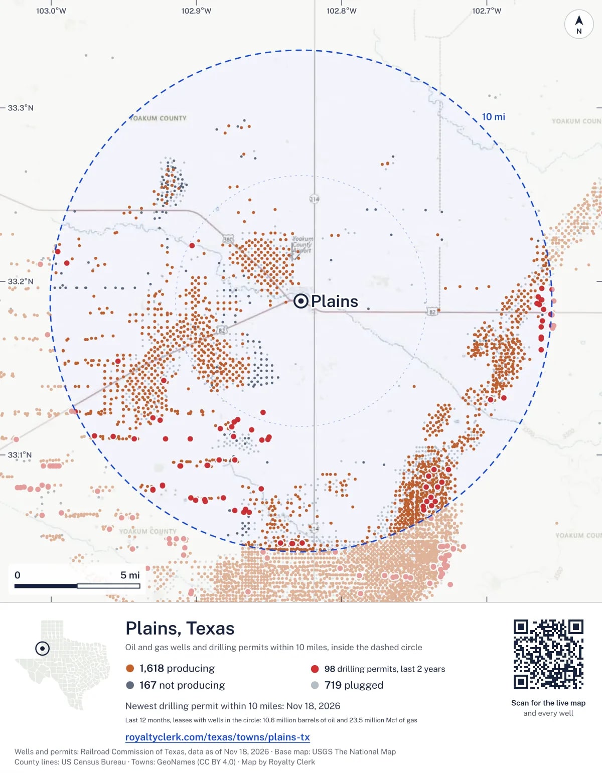
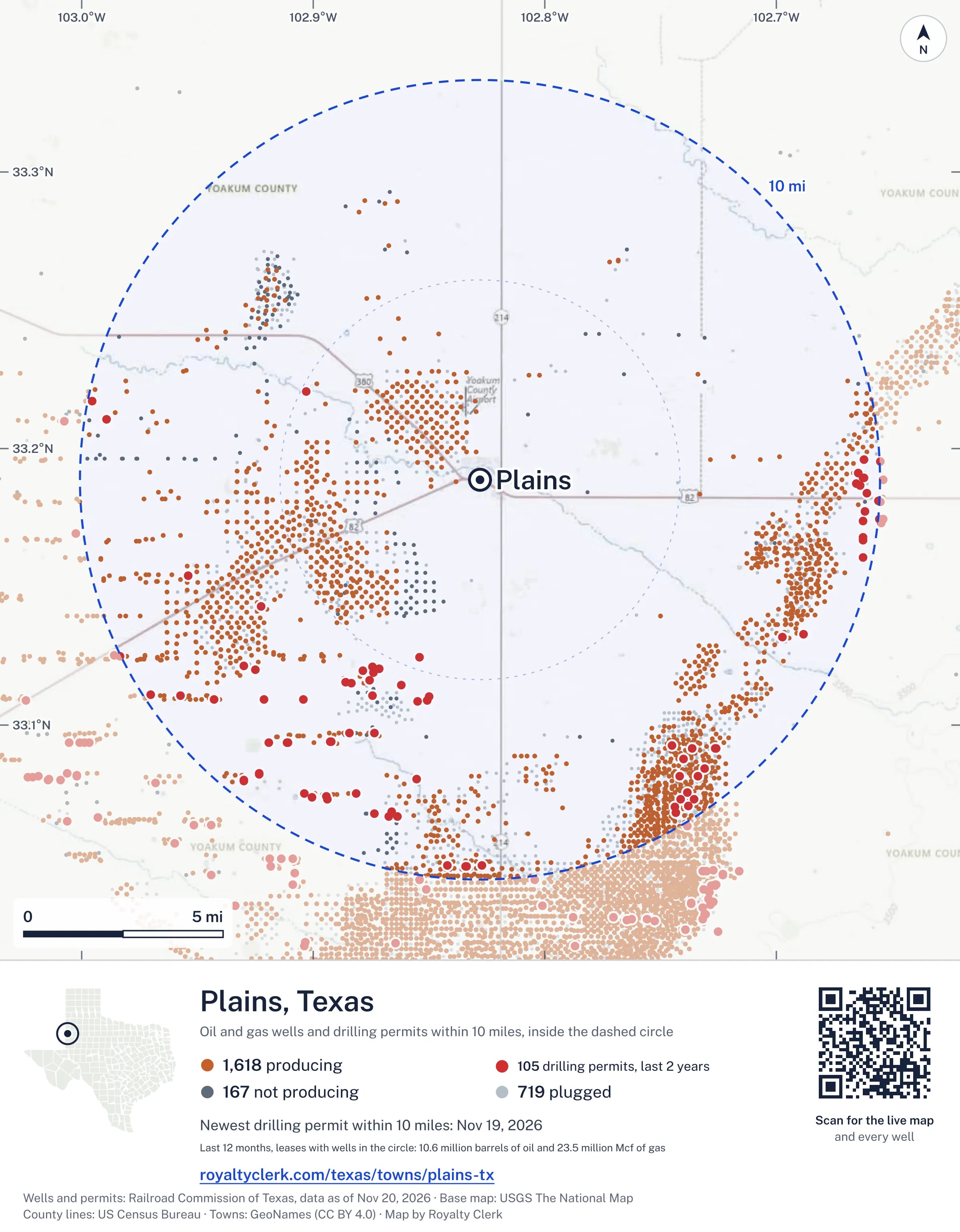
The map picture
The page's map with its legend and credit, as a JPEG.
The live map on your page
A frame that loads its picture first and the live map on a tap. No cookies.
How to cite
Railroad Commission of Texas records of the wells and drilling permits within 10 miles of Plains, mapped by Royalty Clerk (https://royaltyclerk.com/texas/towns/plains-tx), data as of November 15, 2026.
Under a map or a chart: Source: Railroad Commission of Texas · Map: Royalty Clerk, with a link to this page.
The figures say where the state's records put wells and permits, not who owns the land or the minerals. Kits for other Texas towns
Follow it
Watch the 10 miles around Plains
Watching a place says nothing about who owns the land or the minerals there. For the whole county, or one survey, use the Yoakum County well watch.
FAQ
Questions people ask
How many oil and gas wells are near Plains?
2,504 wells with a location on the Railroad Commission's map lie within 10 miles of Plains: 1,618 on leases that are producing, 167 not producing and 719 plugged. The state also issued 97 drilling permits with a well location in that circle in the last 24 months.
What are the coordinates on this page?
Latitude and longitude of the well's surface location in NAD83, the coordinates map apps use. They come from the Railroad Commission's well layers as published, and from its drilling permit files, which are published in the older NAD27 and converted here. Paste them into any map app. A horizontal well's bottom hole can be a mile or two away from its surface location.
Do I own minerals under a well near Plains?
A well nearby says nothing about who owns the minerals under it. The county's mineral roll lists who is paid on each producing lease. Search a name to see whether the Yoakum County roll lists it.
Is drilling near Plains picking up or slowing down?
Drilling permits near Plains are rising: 69 permits in the last 12 months, 28 in the 12 months before. Most of them are south of town: 76 of 97 lie on that side. The nearest is 4.7 miles south of the town's point. A permit is permission to drill, not a well.
When does a new well near Plains start paying royalties?
Texas law gives the payor 120 days after the end of the month of first sale to send the first payment (Natural Resources Code 91.402). The next date on file for a lease near Plains is November 28, 2026. The date is the earliest a first payment becomes late, not a promise: a title question or an unsigned division order can hold a check back.
How much are the oil and gas near Plains worth?
The 217 producing leases with a well within 10 miles sold about $888 million of oil and gas in their newest 12 months on file, at the public monthly prices and before taxes and costs. That is what the leases sold, not what a tract of land or a mineral interest is worth: an owner is paid a share of one lease.
A relative owned minerals near Plains and has died. What now?
The county mineral roll still lists 735 accounts in the name of an estate on leases near Plains. Search the family name first. If an account turns up, the title usually has to be moved to the heirs before the operator will pay them.
My checks from a lease here stopped. Why?
The usual reasons: the lease stopped producing, a new operator took it over, or the operator put the payments in suspense over a title or address question. Near Plains, 17 leases went quiet and 30 changed operator; both lists are on this page.
Own land or minerals near Plains?
The next first check near Plains falls due by November 28, 2026. See whether a county roll lists your name, and get an email when a permit or a new well is filed near you.
Sources
Primary sources, opened on 29 September 2026. Statute text is the current version on statutes.capitol.texas.gov.