
US Census Bureau ZIP code areas · Railroad Commission of Texas wells
Oil and gas wells by Texas ZIP code
- 1,989Texas ZIP codes
- 1,101with a well inside
- 881with 10 or more
- 429,537wells inside them
Where the wells are
Texas by its wells, and the busiest ZIP codes
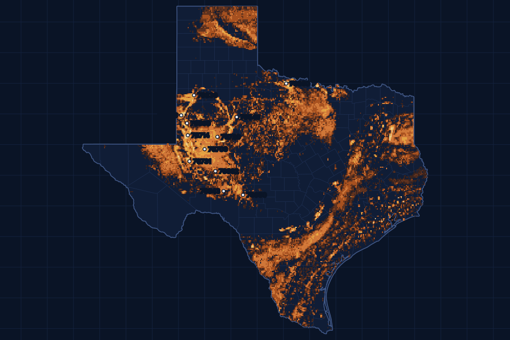
By wells inside
The 20 ZIP codes with the most wells
Located wells inside each ZIP code's Census outline, producing or not.
- 179706 · Midland County12,051 wells
- 279714 · Andrews9,422 wellsAndrews County
- 379720 · Big Spring7,899 wellsHoward County
- 476950 · Sonora6,879 wellsSutton County
- 576932 · Big Lake6,731 wellsReagan County
- 676943 · Ozona6,665 wellsCrockett County
- 779731 · Crane6,493 wellsCrane County
- 879336 · Levelland6,344 wellsHockley County
- 976360 · Electra6,224 wellsWichita County
- 1079360 · Seminole5,939 wellsGaines County
- 1179549 · Snyder5,806 wellsScurry County
- 1279782 · Stanton5,385 wellsMartin County
- 1379323 · Denver City4,765 wellsGaines County
- 1479766 · Ector County4,282 wells
- 1579772 · Pecos3,988 wellsReeves County
- 1679745 · Kermit3,847 wellsWinkler County
- 1779739 · Garden City3,825 wellsGlasscock County
- 1876367 · Iowa Park3,816 wellsWichita County
- 1979355 · Plains3,776 wellsYoakum County
- 2079755 · Upton County3,714 wells
A to Z by county
Every ZIP code with 10 or more wells
881 ZIP codes in 208 counties, filed under the county their middle lies in. The number is the wells inside.
Anderson County
Andrews County
Angelina County
Aransas County
Archer County
Atascosa County
Austin County
Bastrop County
Baylor County
Bee County
Bexar County
Borden County
Bowie County
Brazoria County
Brazos County
Brooks County
Brown County
Burleson County
Caldwell County
Calhoun County
Callahan County
Camp County
Carson County
Cass County
Chambers County
Cherokee County
Childress County
Clay County
Cochran County
Coke County
Coleman County
Colorado County
Comanche County
Concho County
Cooke County
Cottle County
Crane County
Crockett County
Crosby County
Dallam County
Dallas County
Dawson County
Denton County
DeWitt County
Dickens County
Dimmit County
Duval County
Eastland County
Ector County
Edwards County
Ellis County
Erath County
Falls County
Fayette County
Fisher County
Foard County
Fort Bend County
Franklin County
Freestone County
Frio County
Gaines County
Galveston County
Garza County
Glasscock County
Goliad County
Gonzales County
Gray County
Grayson County
Gregg County
Grimes County
Guadalupe County
Hale County
Hamilton County
Hansford County
Hardeman County
Hardin County
Harris County
Harrison County
Hartley County
Haskell County
Hemphill County
Henderson County
Hidalgo County
Hill County
Hockley County
Hood County
Hopkins County
Houston County
Howard County
Hutchinson County
Irion County
Jack County
Jackson County
Jasper County
Jefferson County
Jim Hogg County
Jim Wells County
Johnson County
Jones County
Karnes County
Kenedy County
Kent County
Kimble County
King County
Kleberg County
Knox County
La Salle County
Lamar County
Lamb County
Lavaca County
Lee County
Leon County
Liberty County
Limestone County
Lipscomb County
Live Oak County
Loving County
Lubbock County
Lynn County
Madison County
Marion County
Martin County
Matagorda County
Maverick County
McCulloch County
McLennan County
McMullen County
Medina County
Menard County
Midland County
Milam County
Mitchell County
Montague County
Montgomery County
Moore County
Morris County
Motley County
Nacogdoches County
Navarro County
Newton County
Nolan County
Nueces County
Ochiltree County
Orange County
Palo Pinto County
Panola County
Parker County
Pecos County
Polk County
Potter County
Reagan County
Red River County
Reeves County
Refugio County
Roberts County
Robertson County
Runnels County
Rusk County
Sabine County
San Augustine County
San Jacinto County
San Patricio County
Schleicher County
Scurry County
Shackelford County
Shelby County
Sherman County
Smith County
Somervell County
Starr County
Stephens County
Sterling County
Stonewall County
Sutton County
Tarrant County
- 7505430
- 7526128
- 7600178
- 7600224
- 7600611
- 7601066
- 7601129
- 7601216
- 7601327
- 7601420
- 7601513
- 7601678
- 7601722
- 7601860
- 76020225
- 76036344
- 7604034
- 7605163
- 76052682
- 7605311
- 7606055
- 76063329
- 7610232
- 7610344
- 7610412
- 7610522
- 76106112
- 7610733
- 76108220
- 7610940
- 7611020
- 7611123
- 7611265
- 7611444
- 7611640
- 7611770
- 7611867
- 76119147
- 7612038
- 7612352
- 76126497
- 7613155
- 7613223
- 7613317
- 7613445
- 7613585
- 7613736
- 76140197
- 76177103
- 76179586
- 7618037
- 7618227
- 7624415
- 7624812
Taylor County
Terrell County
Terry County
Throckmorton County
Titus County
Tom Green County
Travis County
Trinity County
Tyler County
Upshur County
Upton County
Val Verde County
Van Zandt County
Victoria County
Walker County
Waller County
Ward County
Washington County
Webb County
Wharton County
Wheeler County
Wichita County
Wilbarger County
Willacy County
Williamson County
Wilson County
Winkler County
Wise County
Wood County
Yoakum County
Young County
Zapata County
Zavala County
FAQ
Questions people ask
Where do the ZIP code areas come from?
From the US Census Bureau's ZIP Code Tabulation Areas, its public map of the area each ZIP code covers, built from census blocks. The Postal Service does not publish ZIP code boundaries; the Census areas match them closely but not to the street.
Why is my ZIP code not listed?
The list below holds the ZIP codes with 10 or more wells inside them. Every other Texas ZIP code still has its page: type it in the box above to see the wells nearest to it.
Does a well in my ZIP code mean I own minerals?
No. Minerals are owned tract by tract, often apart from the land. The county's mineral roll lists who is paid on each producing lease.
Sources
- US Census Bureau, 2020 ZIP Code Tabulation Areas, cartographic boundary file at 1:500,000www2.census.gov/geo/tiger/GENZ2020/shp/cb_2020_us_zcta520_500k.zip · file of May 19, 2023, read November 14, 2026
- Railroad Commission of Texas, well layers and drilling permit fileswww.rrc.texas.gov/resource-center/research/data-sets-available-for-download/ · loaded as the state publishes them; figures kept a day
- US Census Bureau, cartographic boundary files (county lines), through the us-atlas package 3.0.1www.census.gov/geographies/mapping-files/time-series/geo/cartographic-boundary.html · built into the site with its well maps
- GeoNames, towns and their points (CC BY 4.0)www.geonames.org/ · built into the site with its town pages