
Texas county · RRC district 04
Starr County, Texas oil and gas
- 17,275,666mcf gas in the last 12 months
- 857producing leases
- 1,896wells on the map
- 12drilling locations in two years
Oil wells and drilling locations in Starr County
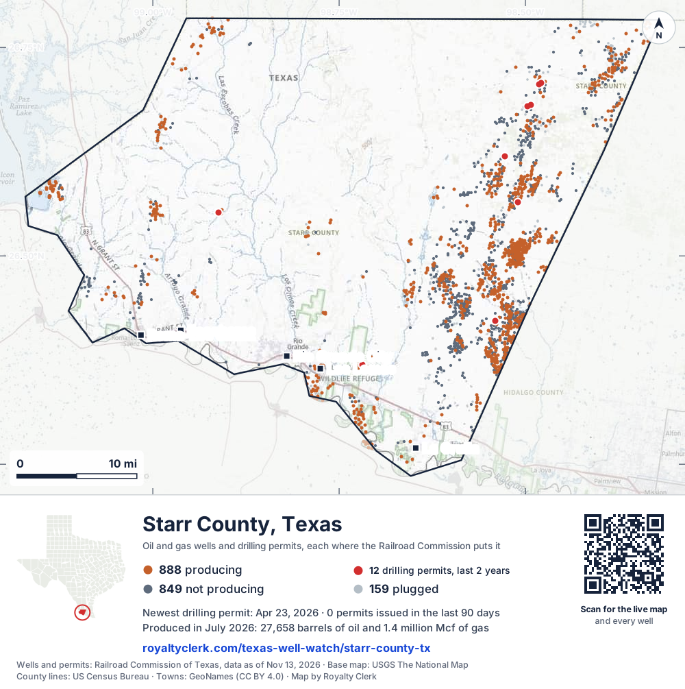
- Drilling locations12Permits issued in the last two years
- Producing wells888On a lease reporting production now
- Not producing849Shut in, inactive or no lease on record
- Plugged159The state's wellbore record says plugged
Sources: Railroad Commission of Texas well layers and permit files, US Census Bureau county outline, town points from GeoNames (CC BY 4.0), base map from USGS The National Map. A dot is a surface location; a horizontal well runs a mile or more from it.
1,896 wells with a location on the state's map (888 producing, 849 not producing, 159 plugged) and 12 drilling locations permitted in the last 24 months, each where the Railroad Commission puts it.
Use this map on your site
You may show this map on any site, unchanged. Keep the credit line and its link to Royalty Clerk under the map. The picture updates by itself as the state records new wells and permits.
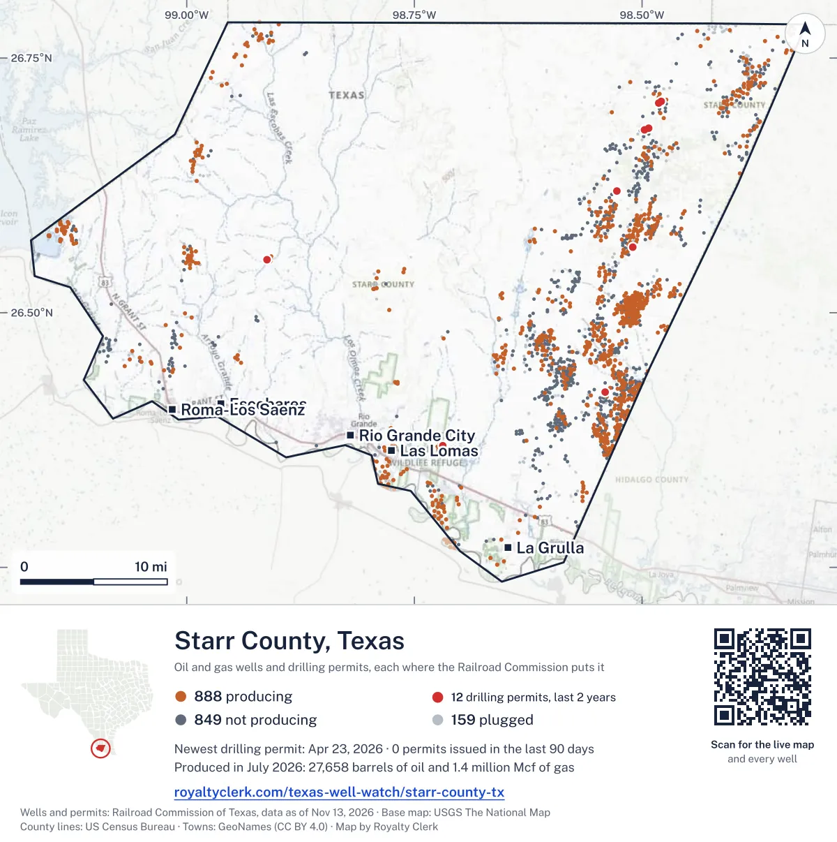
<a href="https://royaltyclerk.com/texas/counties/starr-county-tx"><img src="https://royaltyclerk.com/maps/county-wells/starr-county-tx.svg" alt="Map of Starr County, Texas, with 1,896 oil and gas wells and 12 recent drilling locations as dots." width="1000" height="1005" loading="lazy" style="max-width:100%;height:auto;border:0"></a>
<p style="margin:4px 0 0;font-size:14px">Map: <a href="https://royaltyclerk.com/texas/counties/starr-county-tx">Starr County, Texas oil and gas wells</a> by Royalty Clerk, from Railroad Commission of Texas records</p>
Wells near a town: Escobares · La Grulla · Las Lomas · Rio Grande City · Roma · Roma-Los Saenz · Newest drilling permits in Starr County · Wells by ZIP code
Starr County reported 17 million mcf of gas and 382,303 barrels of oil in the last 12 months. That ranks 65th of 197 Texas counties by gas.
County dossier
August 2026 is still coming in. About 89% of Texas leases have reported it so far, so this page counts through July 2026 until it is fully reported.
- Producing leases
- 857of 1,815 on record
- Operators
- 32
- Fields
- 136
- Top operator
- Merit Energy Company
Own minerals in Starr County?
A family member owned minerals here?
Search their name: a family member who owned minerals hereWhere it sits
This county
- Oil, last 12 months
- 382,303 bbl
- Share of Texas gas
- 0.1%
- Wells on record
- 1,896on leases with production reports
- Data through
- Jul 2026
Five years of output in Starr County
Gas output in Starr County fell 7% over the last 12 months
17M mcf through Jul 2026, against 18M mcf a year earlier. Peak Aug 2021: 2.1M mcf.
Oil output in Starr County fell 12% over the last 12 months
382k bbl through Jul 2026, against 433k bbl a year earlier. Peak Mar 2022: 52.6k bbl.
SourceTexas Railroad Commission Production Data Query, county totals, through Jul 2026, file dated Oct 20, 2026.
Cite or embed this chart
Free to use for Starr County, Texas, with a credit and a link. Copy what you need.
Credit line
Source: Royalty Clerk analysis of Texas Railroad Commission filings, https://royaltyclerk.com/texas/counties/starr-county-tx, data to July 2026.
The chart on your own page
Free to embed on any site. Keep the “Source: Royalty Clerk” link under the chart.
See the code
<iframe
  src="https://royaltyclerk.com/embed/counties/starr-county-tx"
  title="Royalty Clerk: oil and gas production, Starr County, Texas"
  width="100%"
  height="400"
  style="border:0"
  loading="lazy"></iframe>
<p style="margin:4px 0 0;font-size:14px">Source: <a href="https://royaltyclerk.com/texas/counties/starr-county-tx" target="_blank">Royalty Clerk</a></p>
<script>
window.addEventListener("message", function (e) {
  if (e.origin !== "https://royaltyclerk.com" || !e.data || e.data.type !== "rc-embed-height") return;
  var frames = document.getElementsByTagName("iframe");
  for (var i = 0; i < frames.length; i++) {
    if (frames[i].contentWindow === e.source && e.data.height > 0) frames[i].style.height = Number(e.data.height) + "px";
  }
});
</script>
Starr County oil and gas production by year, 1993 to 2025
Every full year we hold, 1993 to 2025. The highest year for oil since 1993 was 2003, at 3,082,245 bbl. The highest year for gas was 1996, at 189,220,218 mcf.
| Year | Oilbbl | Gasmcf |
|---|---|---|
| 2025 | 431,419 | 17,990,615 |
| 2024 | 429,012 | 18,950,401 |
| 2023 | 485,393 | 21,231,288 |
| 2022 | 504,669 | 23,388,292 |
| 2021 | 484,973 | 25,443,366 |
| 2020 | 574,287 | 29,139,769 |
| 2019 | 740,802 | 34,070,930 |
| 2018 | 913,198 | 36,107,638 |
| 2017 | 858,794 | 38,205,383 |
| 2016 | 884,245 | 40,855,663 |
| 2015 | 1,071,161 | 49,878,354 |
| 2014 | 1,321,087 | 55,337,631 |
| 2013 | 1,380,816 | 63,412,040 |
| 2012 | 1,656,693 | 76,193,553 |
| 2011 | 1,717,354 | 82,525,144 |
| 2010 | 1,924,051 | 95,172,839 |
| 2009 | 2,439,123 | 117,971,475 |
| 2008 | 2,559,800 | 129,902,220 |
| 2007 | 2,367,586 | 122,104,487 |
| 2006 | 2,197,450 | 120,459,292 |
| 2005 | 2,395,071 | 129,542,236 |
| 2004 | 2,368,352 | 142,812,568 |
| 2003 | 3,082,245 | 172,392,708 |
| 2002 | 3,080,367 | 175,649,104 |
| 2001 | 2,506,725 | 148,803,826 |
| 2000 | 2,846,264 | 129,876,136 |
| 1999 | 1,928,388 | 125,172,064 |
| 1998 | 1,898,748 | 146,577,495 |
| 1997 | 1,656,323 | 172,240,135 |
| 1996 | 1,616,036 | 189,220,218 |
| 1995 | 1,523,719 | 178,515,810 |
| 1994 | 1,474,739 | 135,022,649 |
| 1993 | 1,592,426 | 96,549,328 |
SourceTexas Railroad Commission production records, added up by county and calendar year. Oil includes condensate; gas includes casinghead gas. The year in progress is left out until it is complete.
The biggest leases in Starr County
Under each volume: change on the year before.
25,620bbl oil−3%
24,852bbl oil−21%
20,411bbl oiln/a
18,349bbl oil−13%
364,443mcf gasn/a
13,562bbl oil−22%
271,203mcf gas−25%
10,600bbl oil−31%
169,728mcf gas−19%
7,081bbl oil−6%
160,193mcf gas−12%
6,803bbl oil+5%
154,022mcf gas−12%
150,658mcf gas−8%
139,598mcf gas−4%
133,696mcf gas−8%
133,509mcf gas−12%
130,854mcf gas−20%
129,718mcf gas−8%
129,179mcf gas−18%
5,194bbl oil−32%
119,945mcf gas−2%
116,336mcf gas+1%
106,424mcf gas+79%
4,550bbl oil−37%
Showing 25 of 150 (the 150 largest of 857), ranked by output value.
SourceTexas Railroad Commission Production Data Query.
Who runs the leases, and what they produce
Operators in Starr County, by gas
Merit Energy leads
Fields in Starr County, by gas
Hinde (Vicksburg Consolidated) leads
- Hinde (Vicksburg Consolidated)168 leases · District 04 · Field 415372503.2Mmcf
- LA Copita (Vicksburg Cons.)65 leases · District 04 · Field 507006201.8Mmcf
- Rincon, N. (Vicksburg Cons.)36 leases · District 04 · Field 767234501.7Mmcf
- Garcias Ridge (Queen City)38 leases · District 04 · Field 33972360970kmcf
- Flores, W. (Vksbrg, Geopressure)47 leases · District 04 · Field 31545790792kmcf
- Rincon (Vicksburg Cons.)57 leases · District 04 · Field 76721550662kmcf
- Alvarado (Vicksburg)36 leases · District 04 · Field 02100625604kmcf
- Arroyo Grande (Queen City)7 leases · District 04 · Field 0394365091.5kmcf
More operators here
Recent drilling permits in Starr County
RICHMOND #17
new drill · Petrovybe Opco LLC · Starr County
Permit 0915027 · Apr 23, 2026
MONTALVO, N. R. #62
recompletion · Triad O&G, LLC · Starr County
Permit 0914356 · Mar 27, 2026
BROCK #5
new drill · Ilex Energy Corporation · Starr County
Permit 0913943 · Mar 10, 2026
I.V. MONTALVO 'A' #20
recompletion · Killam Oil Co., Ltd. · Starr County
Permit 0913510 · Feb 20, 2026
ALBERTO ALANIZ #1R
new drill · Mueller Exploration, Inc. · Starr County
Permit 0912483 · Jan 5, 2026
I.V. MONTALVO 'C' #49
recompletion · Killam Oil Co., Ltd. · Starr County
Permit 0911186 · Oct 20, 2025