
Texas county · RRC district 06
Wood County, Texas oil and gas
- 3,041,939bbl oil in the last 12 months
- 237producing leases
- 1,694wells on the map
- 16drilling locations in two years
The story
Wood County turned from oil to gas in 2009
Wood County turned from oil to gas in 2009, and gas has made more of the county's output in every full calendar year since.
In 2025, 35 operators filed reports here, a little over a third as many as in 1993.
Leases have changed hands. Shiloh Operating LLC handed 32 leases to Southwest Operating, Inc.-Tyler in 2007. Atlas Operating LLC led the county by lease count from 2010 to 2020, and Southwest Operating, Inc.-Tyler has led since 2021. Today Mmgl East Texas II, LLC reports 87.0% of the county's output, counted in barrels of oil equivalent. Operators filed 15 drilling permits in the last 12 months, and none of them are for horizontal wells.
Not a forecast, not reserves.
Key moments
- 1993Cross Timbers Operating Company led the county with 63 leases.
- 2005Gas made more of the county's output than oil.
- 2007Shiloh Operating LLC handed 32 leases to Southwest Operating, Inc.-Tyler.
- 2009Gas made more output than oil in every full year through 2025.
- 2010Atlas Operating LLC took over 51 leases from Pioneer Exploration, LLC.
- 2021Southwest Operating, Inc.-Tyler took the lead with 54 leases.
- 2024Biggest full year for gas, 56,391,334 mcf, under Southwest Operating, Inc.-Tyler.
Oil wells and drilling locations in Wood County
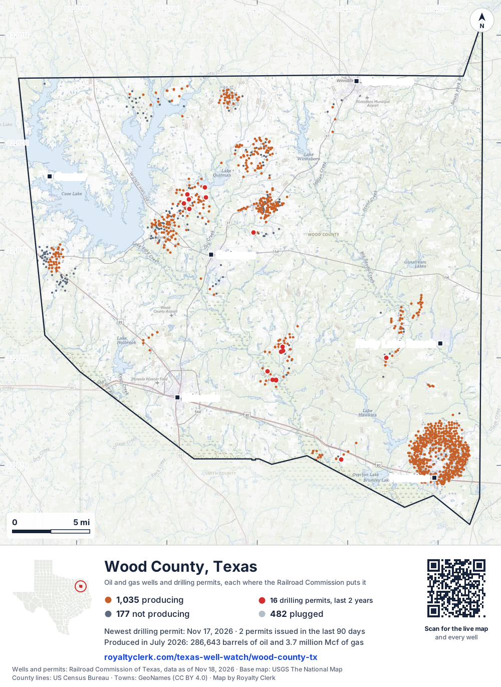
- Drilling locations16Permits issued in the last two years
- Producing wells1,035On a lease reporting production now
- Not producing177Shut in, inactive or no lease on record
- Plugged482The state's wellbore record says plugged
Sources: Railroad Commission of Texas well layers and permit files, US Census Bureau county outline, town points from GeoNames (CC BY 4.0), base map from USGS The National Map. A dot is a surface location; a horizontal well runs a mile or more from it.
1,694 wells with a location on the state's map (1,035 producing, 177 not producing, 482 plugged) and 16 drilling locations permitted in the last 24 months, each where the Railroad Commission puts it.
Use this map on your site
You may show this map on any site, unchanged. Keep the credit line and its link to Royalty Clerk under the map. The picture updates by itself as the state records new wells and permits.
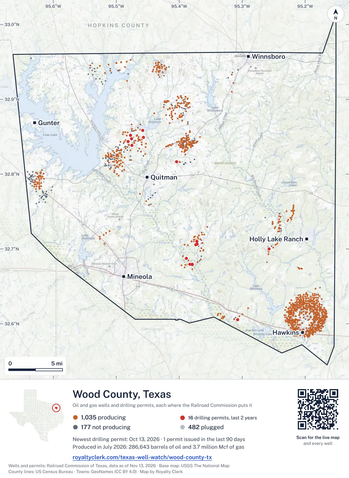
<a href="https://royaltyclerk.com/texas/counties/wood-county-tx"><img src="https://royaltyclerk.com/maps/county-wells/wood-county-tx.svg" alt="Map of Wood County, Texas, with 1,694 oil and gas wells and 16 recent drilling locations as dots." width="1000" height="1371" loading="lazy" style="max-width:100%;height:auto;border:0"></a>
<p style="margin:4px 0 0;font-size:14px">Map: <a href="https://royaltyclerk.com/texas/counties/wood-county-tx">Wood County, Texas oil and gas wells</a> by Royalty Clerk, from Railroad Commission of Texas records</p>
Wells near a town: Gunter · Hawkins · Holly Lake Ranch · Mineola · Quitman · Winnsboro · Newest drilling permits in Wood County · Wells by ZIP code
Wood County reported 3 million barrels of oil and 43 million mcf of gas in the last 12 months. That ranks 43rd of 225 Texas counties by oil.
County dossier
August 2026 is still coming in. About 89% of Texas leases have reported it so far, so this page counts through July 2026 until it is fully reported.
- Producing leases
- 237of 367 on record
- Operators
- 27
- Fields
- 89
- Top operator
- Mmgl East Texas II, LLC
Own minerals in Wood County?
A family member owned minerals here?
Search their name: a family member who owned minerals hereWhere it sits
This county
- Gas, last 12 months
- 43,246,843 mcf
- Share of Texas oil
- 0.1%
- Wells on record
- 1,703on leases with production reports
- Data through
- Jul 2026
If you own here
- Several mineral tax bills
The 2026 county roll lists 37,550 accounts for 258 leases; the tool explains why each mineral tax bill is a separate account.
- Mineral interest finder
19 leases here carry an estate, heirs or trust name; the tool searches a name on county mineral rolls for accounts and leases.
- Find the land on my deed
15 drilling permits in the last 12 months; the tool finds a section or abstract on the survey map, with its wells and permits.
Questions owners ask
- Which product has made more of the county's output, and since when?
- Oil made more of the county's output, counted in barrels of oil equivalent, from 1993 to 2004 and again from 2007 to 2008. Gas made more from 2005 to 2006 and from 2009 to 2025. Gas has been ahead in every full calendar year since 2009.
- Who has run the most leases here, and how many now?
- Southwest Operating, Inc.-Tyler led the county by lease count from 2021, with 71 leases reporting in 2025. Atlas Operating LLC led from 2010 to 2020. Mmgl East Texas II, LLC has 9 producing leases here and reports 87.0% of the county's oil and gas.
- Why do some leases here carry an estate, heirs or trust name?
- The state's records show 19 leases in this county with an estate, heirs or trust name. This page gives county totals only, so it does not name any of those leases or owners. Mineral interest finder
- Are drilling permits being filed in this county now?
- Operators filed 15 drilling permits in the last 12 months, against 4 in the 12 months before. None of the 15 are for horizontal wells. Montare Operating, Ltd. filed 6 of them, and TTK Energy LLC filed 3. Find the land on my deed
Related pages
- Mmgl East Texas II, LLC
Reports 87.0% of the county's oil and gas, with 9 producing leases.
- Southwest Operating, Inc.-Tyler
Led the county by lease count since 2021; 53 producing leases here.
- Montare Operating, Ltd.
Filed 6 of the 15 drilling permits in the last 12 months.
- Hawkins
Top field here now, by output; it has one producing lease.
- Neuhoff (TP CV Cons.)
Second-ranked field here now, with 8 producing leases.
From the state's records through July 2026.
Oil and gas over the last five years
Oil output in Wood County fell 5% over the last 12 months
3M bbl through Jul 2026, against 3.2M bbl a year earlier. Peak Mar 2022: 315k bbl.
Gas output in Wood County fell 13% over the last 12 months
43M mcf through Jul 2026, against 49M mcf a year earlier. Peak May 2022: 5.2M mcf.
SourceTexas Railroad Commission Production Data Query, county totals, through Jul 2026, file dated Oct 20, 2026.
Cite or embed this chart
Free to use for Wood County, Texas, with a credit and a link. Copy what you need.
Credit line
Source: Royalty Clerk analysis of Texas Railroad Commission filings, https://royaltyclerk.com/texas/counties/wood-county-tx, data to July 2026.
The chart on your own page
Free to embed on any site. Keep the “Source: Royalty Clerk” link under the chart.
See the code
<iframe
  src="https://royaltyclerk.com/embed/counties/wood-county-tx"
  title="Royalty Clerk: oil and gas production, Wood County, Texas"
  width="100%"
  height="400"
  style="border:0"
  loading="lazy"></iframe>
<p style="margin:4px 0 0;font-size:14px">Source: <a href="https://royaltyclerk.com/texas/counties/wood-county-tx" target="_blank">Royalty Clerk</a></p>
<script>
window.addEventListener("message", function (e) {
  if (e.origin !== "https://royaltyclerk.com" || !e.data || e.data.type !== "rc-embed-height") return;
  var frames = document.getElementsByTagName("iframe");
  for (var i = 0; i < frames.length; i++) {
    if (frames[i].contentWindow === e.source && e.data.height > 0) frames[i].style.height = Number(e.data.height) + "px";
  }
});
</script>
Oil and gas by year back to January 1993
Every full year we hold, 1993 to 2025. The highest year for oil since 1993 was 1993, at 9,571,779 bbl. The highest year for gas was 2024, at 56,391,334 mcf.
| Year | Oilbbl | Gasmcf |
|---|---|---|
| 2025 | 3,039,713 | 43,986,700 |
| 2024 | 3,047,921 | 56,391,334 |
| 2023 | 3,076,547 | 49,198,336 |
| 2022 | 3,388,795 | 53,501,583 |
| 2021 | 3,334,965 | 55,094,389 |
| 2020 | 3,283,698 | 53,683,000 |
| 2019 | 3,382,527 | 54,637,548 |
| 2018 | 3,400,310 | 56,208,807 |
| 2017 | 3,443,451 | 55,076,912 |
| 2016 | 3,413,881 | 51,126,247 |
| 2015 | 3,430,676 | 53,726,113 |
| 2014 | 3,594,037 | 55,226,896 |
| 2013 | 3,486,396 | 52,951,572 |
| 2012 | 3,506,001 | 29,063,175 |
| 2011 | 3,230,299 | 27,516,522 |
| 2010 | 3,367,049 | 31,704,853 |
| 2009 | 3,163,637 | 21,964,149 |
| 2008 | 3,597,861 | 9,352,280 |
| 2007 | 3,959,985 | 9,678,528 |
| 2006 | 4,304,903 | 28,607,242 |
| 2005 | 4,375,152 | 30,738,536 |
| 2004 | 4,620,378 | 13,686,637 |
| 2003 | 5,281,113 | 12,193,595 |
| 2002 | 5,843,707 | 12,957,296 |
| 2001 | 6,452,630 | 13,487,935 |
| 2000 | 7,016,603 | 13,525,562 |
| 1999 | 6,336,445 | 14,959,464 |
| 1998 | 6,379,968 | 15,554,288 |
| 1997 | 6,407,875 | 36,774,920 |
| 1996 | 6,991,432 | 39,219,971 |
| 1995 | 7,879,535 | 36,866,826 |
| 1994 | 8,713,462 | 37,048,889 |
| 1993 | 9,571,779 | 39,809,245 |
SourceTexas Railroad Commission production records, added up by county and calendar year. Oil includes condensate; gas includes casinghead gas. The year in progress is left out until it is complete.
Wood County appraisal district, 2026 mineral roll
County appraisal roll totals for tax year 2026
At least 330 of the 35,090 royalty-interest records on Wood County's 2026 mineral roll are still titled to an estate (0.94%). We publish counts only. No owner’s name or address is on this page; to look for one family, search its name.
- Royalty-interest records, 2026 roll
- 35,090
- Still titled to an estate, at least
- 330
- Share of the roll
- 0.94%
SourceRoyalty Clerk count of the Wood County mineral appraisal roll of 2026, read November 2026. A record is one line of the roll, not one person.
Which leases carry the most output now
Under each volume: change on the year before.
2,304,055bbl oil−2%
47,591bbl oil−7%
44,513bbl oil+3%
41,615bbl oil+14%
41,537bbl oil−22%
27,653bbl oil−22%
26,584bbl oil−12%
25,420bbl oil−27%
23,807bbl oil−34%
22,688bbl oil+17%
528,819mcf gas−14%
460,632mcf gasn/a
446,988mcf gasn/a
431,467mcf gas+34%
16,705bbl oil−19%
16,381bbl oil−8%
346,156mcf gas−4%
13,567bbl oil−28%
269,763mcf gas−22%
11,553bbl oil−57%
10,550bbl oil−3%
9,026bbl oiln/a
8,546bbl oiln/a
8,512bbl oil−15%
8,303bbl oil−16%
Showing 25 of 150 (the 150 largest of 237), ranked by output value.
SourceTexas Railroad Commission Production Data Query.
Who runs the leases, and what they produce
Operators in Wood County, by oil
Which operators produce the most output now
- Mmgl East Texas II, LLC9 leases2.3Mbbl
- Montare Operating, Ltd.20 leases219kbbl
- Strand Energy, L.c.4 leases93.3kbbl
- Valence Operating Company12 leases77.7kbbl
- Southwest Operating, Inc.-Tyler53 leases57kbbl
- TTK Energy LLC16 leases44.6kbbl
- GTG Operating, LLC3 leases43.6kbbl
- Linder, John Operating Co., LLC14 leases42.8kbbl
Fields in Wood County, by oil
Which fields produce the most output now
- Hawkins1 lease · District 06 · Field 397240012.3Mbbl
- Como (Rodessa Hill, Lo.)8 leases · District 05 · Field 1994742673.6kbbl
- Neuhoff (Buda-Woodbine)2 leases · District 06 · Field 6501105068.3kbbl
- Crow (Paluxy, Lower)4 leases · District 06 · Field 2197141055.4kbbl
- Neuhoff (TP CV Cons.)8 leases · District 06 · Field 6501145054.7kbbl
- Crow (Sub-Clarksville)2 leases · District 06 · Field 2197170049.3kbbl
- Neuhoff (Woodbine)1 lease · District 06 · Field 6501150047.6kbbl
- Schneider (Buda)1 lease · District 06 · Field 8153320041.6kbbl
More operators here
Drilling permits filed in the last 12 months
TAYLOR, P. -A- #6
recompletion · Atlantis Oil Company, Inc. · Wood County
Permit 0919179 · Oct 13, 2026
MCALLISTER #1
recompletion · Fair Oil, Ltd. · Wood County
Permit 0917790 · Aug 13, 2026
NEUHOFF (BUDA-WOODBINE) UNIT #18ST
recompletion · Montare Operating, Ltd. · Wood County
Permit 0916760 · Jun 29, 2026
NEUHOFF (BUDA-WOODBINE) UNIT #10ST
recompletion · Montare Operating, Ltd. · Wood County
Permit 0916758 · Jun 29, 2026
SASI RANCH UNIT #4ST
recompletion · Montare Operating, Ltd. · Wood County
Permit 0916761 · Jun 26, 2026
SASI RANCH UNIT #2XT
recompletion · Montare Operating, Ltd. · Wood County
Permit 0916759 · Jun 26, 2026