
Railroad Commission of Texas · major oil and gas formations
Texas oil and gas plays and basins
- 5plays
- 149counties
- 7,573drilling permits in 12 months
- 93%of the state's permits
Where Texas drills
Five plays on one map
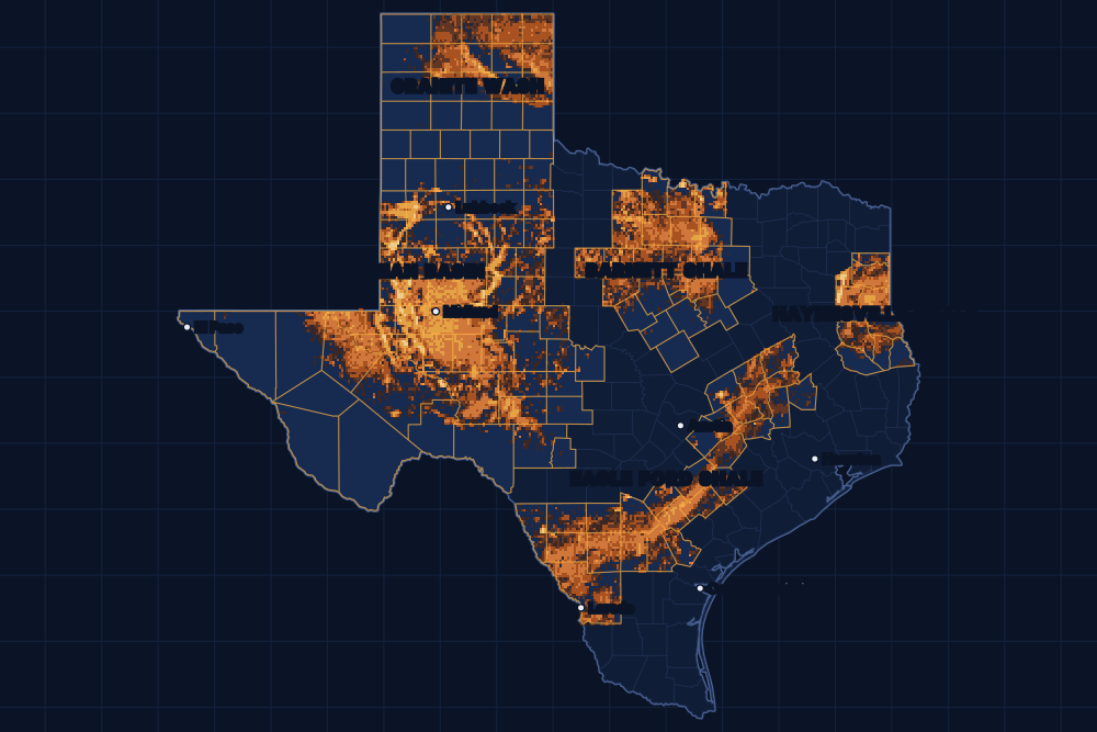
By drilling permits
The plays, busiest first
Drilling permits of the last 12 months in each play's counties, and the county with the most.
1 · Basin · oil and gas
Permian Basin
An oil and gas region of West Texas and southeastern New Mexico, about 250 miles wide and 300 miles long, with more than 7,000 fields. The Spraberry, Wolfcamp, Bone Spring, San Andres and Clear Fork are among the formations that produce there; the Delaware and Midland basins are parts of it.
5,205permits in 12 months · 64% of the state's
61 counties · 245,967 wells on the map · most in Midland County (672)
2 · Shale · oil and gas
Eagle Ford Shale
A shale that runs from the Mexican border into East Texas, about 50 miles wide and 400 miles long and some 250 feet thick. It gives gas, and more oil than most shale plays.
1,565permits in 12 months · 19% of the state's
27 counties · 59,620 wells on the map · most in Webb County (273)
3 · Shale · gas
Haynesville/Bossier Shale
A gas shale of East Texas and western Louisiana, more than 10,000 feet below the surface. Texas and Louisiana name its layers differently, so the same rock is called the Haynesville on one side of the line and the Bossier on the other.
463permits in 12 months · 6% of the state's
10 counties · 27,093 wells on the map · most in San Augustine County (106)
4 · Shale · gas
Barnett Shale
A gas shale that reaches west and south from Dallas over about 5,000 square miles, one of the largest onshore natural gas fields in the United States. The state names its productive part the Newark, East (Barnett Shale) field.
274permits in 12 months · 3% of the state's
25 counties · 56,321 wells on the map · most in Archer County (55)
5 · Tight sand · oil and gas
Granite Wash
A tight sand play of the Texas Panhandle and western Oklahoma, about 160 miles long and 30 miles wide. It gives oil and gas, and is drilled sideways like the shales.
66permits in 12 months · 1% of the state's
26 counties · 32,588 wells on the map · most in Hemphill County (15)
FAQ
Questions people ask
What is a play?
A play is an area where companies drill the same rock the same way, such as a shale drilled with long horizontal wells. The Railroad Commission of Texas describes five major ones and lists the counties of each; these pages use exactly those counties.
Why are the Delaware and Midland basins not here?
They are the two halves of the Permian Basin. The Commission's Permian page names them but does not list their counties, so we count them with the Permian Basin rather than guess where one ends.
My county is not on the map. Does it have oil and gas?
Very likely. Most Texas counties have wells, and plenty are outside the five plays. Every county has its own live map of its wells and drilling permits.
Sources
- Railroad Commission of Texas, major oil and gas formations, and the page of each playwww.rrc.texas.gov/oil-and-gas/major-oil-and-gas-formations/ · read November 14, 2026
- Railroad Commission of Texas, well layers, completion records and drilling permit fileswww.rrc.texas.gov/resource-center/research/data-sets-available-for-download/ · loaded as the state publishes them; figures kept six hours
- US Census Bureau, cartographic boundary files (county lines), through the us-atlas package 3.0.1www.census.gov/geographies/mapping-files/time-series/geo/cartographic-boundary.html · built into the site with its well maps
- GeoNames, towns and their points (CC BY 4.0)www.geonames.org/ · built into the site with its town pages