
Railroad Commission of Texas · week of July 1, 2024
New Texas drilling permits, Jul 1–7, 2024
- 106permits issued
- 84horizontal
- 28counties
- 33operators
That week
Where the state permitted wells
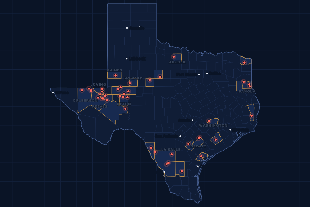
Counties and operators
Who drills, and where
Each county links to its Well Watch page, with its own map and every permit of the last two years. Each operator links to its page.
By county
- 1Upton County19
- 2Culberson County12
- 3Loving County10
- 4Ward County10
- 5De Witt County6
- 6Midland County6
- 7Panola County6
- 8Gaines County5
- 9Webb County5
- 10La Salle County4
- 11Howard County3
- 12Reeves County3
- 13Washington County2
- 14Archer County1
- 15Bowie County1
And 13 more counties with fewer, in the list below.
By operator
- 1EOG Resources, Inc.9
- 2Ovintiv USA Inc.9
- 3Anadarko E&P Onshore LLC8
- 4Chevron U. S. A. Inc.7
- 5Pioneer Natural Res. USA, Inc.7
- 6Sabine Oil & Gas Corporation7
- 7Jetta Operating Company, Inc.6
- 8Burlington Resources O & G Co LP5
- 9McClure Oil Company, Inc.5
- 10XTO Energy Inc.5
- 11Crownquest Operating, LLC4
- 12Firebird Energy II LLC4
- 13Jagged Peak Energy LLC4
- 14Cimarex Energy Co.3
- 15Continental Resources, Inc.2
And 18 more operators with fewer.
Register · July 1–7, 2024
Every permit, newest first
As the state files them: the lease and well, the operator, the kind of permit and the depth. “On the map” opens the county's live map at the well's spot.
Wednesday, July 340 permits
- Archer CountyArthur Ranch, well 2HW Operating, LLC · new drill · vertical · 7,000 ftPermit 0900841 · API 42-009-43359On the map
- Bowie CountyBessie, well 2STMertz Energy Texas LLC · recompletion · vertical · 9,000 ftPermit 0900891 · API 42-037-30354On the map
- De Witt CountyJ-W Crites Ulw C, well 1Burlington Resources O & G Co LP · new drill · horizontal · 17,500 ftPermit 0900684 · API 42-123-35435On the map
- Jones CountyHEP14, well 1Holly Energy Partners-Op, L.P. · new drill · vertical · 350 ftPermit 0900828 · API 42-253-35730On the map
- Karnes CountyPedernales E, well 5HEOG Resources, Inc. · new drill · horizontal · 11,500 ftPermit 0900111 · API 42-255-38095On the map
- Loving CountySovereign 28-0-18-7 H, well 18HAnadarko E&P Onshore LLC · new drill · horizontal · 13,000 ftPermit 0900776 · API 42-301-37032On the map
- Loving CountySovereign 28-0-18-7 G, well 17HAnadarko E&P Onshore LLC · new drill · horizontal · 13,000 ftPermit 0900774 · API 42-301-37031On the map
- Loving CountySovereign 28-0-18-7 F, well 16HAnadarko E&P Onshore LLC · new drill · horizontal · 13,000 ftPermit 0900773 · API 42-301-37030On the map
- Loving CountySovereign 28-0-18-7 E, well 15HAnadarko E&P Onshore LLC · new drill · horizontal · 13,000 ftPermit 0900770 · API 42-301-37029On the map
- Loving CountySovereign 28-0-18-7 D, well 14HAnadarko E&P Onshore LLC · new drill · horizontal · 13,000 ftPermit 0900769 · API 42-301-37028On the map
- Loving CountySovereign 28-0-18-7 C, well 13HAnadarko E&P Onshore LLC · new drill · horizontal · 13,000 ftPermit 0900768 · API 42-301-37027On the map
- Loving CountySovereign 28-0-18-7 B, well 12HAnadarko E&P Onshore LLC · new drill · horizontal · 13,000 ftPermit 0900765 · API 42-301-37026On the map
- Loving CountySovereign 28-0-18-7 A, well 11HAnadarko E&P Onshore LLC · new drill · horizontal · 13,000 ftPermit 0900763 · API 42-301-37025On the map
- Loving CountyShockwave Unit, well 2151HCog Operating LLC · new drill · horizontal · 11,000 ftPermit 0899955 · API 42-301-36942On the map
- Midland CountyTxl 32 Unit 1, well 4171JHXTO Energy Inc. · new drill · horizontal · 10,500 ftPermit 0900952 · API 42-329-47181On the map
- Midland CountyTxl 32 Unit 1, well 4112AHXTO Energy Inc. · new drill · horizontal · 10,500 ftPermit 0900949 · API 42-329-47180On the map
- Midland CountyTxl 32 Unit 1, well 4102BHXTO Energy Inc. · new drill · horizontal · 10,500 ftPermit 0900946 · API 42-329-47179On the map
- Midland CountyTxl 32 Unit 1, well 4173JHXTO Energy Inc. · new drill · horizontal · 10,500 ftPermit 0900943 · API 42-329-47177On the map
- Midland CountyTxl 32 Unit 1, well 4174JHXTO Energy Inc. · new drill · horizontal · 10,500 ftPermit 0900941 · API 42-329-47176On the map
- Nolan CountyHEP15, well 1Holly Energy Partners-Op, L.P. · new drill · vertical · 380 ftPermit 0900939 · API 42-353-33754On the map
- Reeves CountyLegacy 2623A-C3, well 3HContinental Resources, Inc. · new drill · horizontal · 12,200 ftPermit 0900221 · API 42-389-41248On the map
- Upton CountyHensley 41X, well 9HDOvintiv USA Inc. · new drill · horizontal · 10,300 ftPermit 0900970 · API 42-461-42880On the map
- Upton CountyHensley 41G, well 8HDOvintiv USA Inc. · new drill · horizontal · 10,300 ftPermit 0900969 · API 42-461-42879On the map
- Upton CountyHensley 41G, well 7HFOvintiv USA Inc. · new drill · horizontal · 10,300 ftPermit 0900968 · API 42-461-42878On the map
- Upton CountyHensley 41F, well 6HDOvintiv USA Inc. · new drill · horizontal · 10,300 ftPermit 0900966 · API 42-461-42877On the map
- Upton CountyHensley 41F, well 5HDOvintiv USA Inc. · new drill · horizontal · 10,300 ftPermit 0900965 · API 42-461-42876On the map
- Upton CountyHensley 41X, well 4HMOvintiv USA Inc. · new drill · horizontal · 10,300 ftPermit 0900963 · API 42-461-42875On the map
- Upton CountyHensley 41G, well 3HLOvintiv USA Inc. · new drill · horizontal · 10,300 ftPermit 0900962 · API 42-461-42874On the map
- Upton CountyHensley 41F, well 2HMOvintiv USA Inc. · new drill · horizontal · 10,300 ftPermit 0900961 · API 42-461-42873On the map
- Upton CountyBig Bertha 0310 C, well 503HFirebird Energy II LLC · new drill · horizontal · 9,700 ftPermit 0900808 · API 42-461-42862On the map
- Upton CountyBrook D-E17M, well 13HPioneer Natural Res. USA, Inc. · new drill · horizontal · 10,762 ftPermit 0900167 · API 42-461-41731On the map
- Upton CountyBrook D-E17L, well 12HPioneer Natural Res. USA, Inc. · new drill · horizontal · 10,762 ftPermit 0900166 · API 42-461-41730On the map
- Upton CountyBrook D-E17K, well 11HPioneer Natural Res. USA, Inc. · new drill · horizontal · 10,762 ftPermit 0900164 · API 42-461-41729On the map
- Upton CountyBrook D-E17J, well 10HPioneer Natural Res. USA, Inc. · new drill · horizontal · 10,762 ftPermit 0900163 · API 42-461-41745On the map
- Upton CountyBrook D-E17H, well 8HPioneer Natural Res. USA, Inc. · new drill · horizontal · 10,762 ftPermit 0900162 · API 42-461-41746On the map
- Upton CountyBrook D-E17G, well 7HPioneer Natural Res. USA, Inc. · new drill · horizontal · 10,762 ftPermit 0900161 · API 42-461-41738On the map
- Upton CountyBrook D-E17F, well 6HPioneer Natural Res. USA, Inc. · new drill · horizontal · 10,762 ftPermit 0900160 · API 42-461-41737On the map
- Webb CountyMb - Ocho - Lm C, well 114HEOG Resources, Inc. · new drill · horizontal · 14,000 ftPermit 0900936 · API 42-479-45168On the map
- Webb CountyMb - Ocho - Lm B, well 113HEOG Resources, Inc. · new drill · horizontal · 14,000 ftPermit 0900932 · API 42-479-45167On the map
- Webb CountyOcho, well 111HEOG Resources, Inc. · new drill · horizontal · 14,100 ftPermit 0900925 · API 42-479-45165On the map
Tuesday, July 253 permits
- Culberson CountyHay Denise State 08/05, well 0036WCChevron U. S. A. Inc. · new drill · horizontal · 12,000 ftPermit 0900920 · API 42-109-34270On the map
- Culberson CountyHay Denise State 08/05, well 0035WCChevron U. S. A. Inc. · new drill · horizontal · 12,000 ftPermit 0900919 · API 42-109-34269On the map
- Culberson CountyHay Denise State 08/05, well 0034WCChevron U. S. A. Inc. · new drill · horizontal · 12,000 ftPermit 0900918 · API 42-109-34268On the map
- Culberson CountyHay Denise State 08/05, well 0033WCChevron U. S. A. Inc. · new drill · horizontal · 12,000 ftPermit 0900917 · API 42-109-34267On the map
- Culberson CountyHay Denise State 08/05, well 0032WCChevron U. S. A. Inc. · new drill · horizontal · 12,000 ftPermit 0900916 · API 42-109-34263On the map
- Culberson CountyHay Denise State 08/05, well 0031WCChevron U. S. A. Inc. · new drill · horizontal · 12,000 ftPermit 0900914 · API 42-109-34262On the map
- Culberson CountyCathodic Protection, well 2Kinder Morgan Crude & Cond. LLC · new drill · vertical · 600 ftPermit 0900907 · API 42-109-34266On the map
- Culberson CountyOwl Draw 12 Unit I, well 14HCoterra Energy Operating Co. · new drill · horizontal · 15,000 ftPermit 0900903 · API 42-109-34273On the map
- Culberson CountyOwl Draw 12 Unit H, well 13HCimarex Energy Co. · new drill · horizontal · 15,000 ftPermit 0900902 · API 42-109-34272On the map
- Culberson CountyOwl Draw 12 Unit G, well 12HCimarex Energy Co. · new drill · horizontal · 15,000 ftPermit 0900901 · API 42-109-34265On the map
- Culberson CountyOwl Draw 12 Unit F, well 11HCimarex Energy Co. · new drill · horizontal · 15,000 ftPermit 0900900 · API 42-109-34264On the map
- Culberson CountyHay Henley I, well 0015WCChevron U. S. A. Inc. · new drill · horizontal · 10,400 ftPermit 0900601 · API 42-109-34253On the map
- De Witt CountyKolm-Chumchal, well 1HSilverbow Resources Oper, LLC · new drill · horizontal · 16,000 ftPermit 0900780 · API 42-123-35444On the map
- De Witt CountyJustiss-Weigelt Usw B, well 1Burlington Resources O & G Co LP · new drill · horizontal · 17,500 ftPermit 0900682 · API 42-123-35440On the map
- De Witt CountyJustiss-Weigelt Usw A, well 1Burlington Resources O & G Co LP · new drill · horizontal · 17,500 ftPermit 0900681 · API 42-123-35438On the map
- De Witt CountyGunn-J-W Ulw G, well 1Burlington Resources O & G Co LP · new drill · horizontal · 17,500 ftPermit 0900672 · API 42-123-35434On the map
- De Witt CountyGunn-Weigelt Usw E, well 1Burlington Resources O & G Co LP · new drill · horizontal · 17,500 ftPermit 0900630 · API 42-123-35433On the map
- Dimmit CountyComanche, well 7016HEl Toro Resources LLC · new drill · horizontal · 5,200 ftPermit 0900899 · API 42-127-38940On the map
- Ector CountySchlemeyer North 3934B, well 02HContinental Resources, Inc. · new drill · horizontal · 12,000 ftPermit 0900827 · API 42-135-44052On the map
- Gaines CountyMonarch, well 8McClure Oil Company, Inc. · new drill · vertical · 6,000 ftPermit 0900934 · API 42-165-38959On the map
- Gaines CountyMonarch, well 7McClure Oil Company, Inc. · new drill · vertical · 6,000 ftPermit 0900933 · API 42-165-38958On the map
- Gaines CountyMonarch, well 6McClure Oil Company, Inc. · new drill · vertical · 6,000 ftPermit 0900929 · API 42-165-38957On the map
- Gaines CountyMonarch, well 5McClure Oil Company, Inc. · new drill · vertical · 6,000 ftPermit 0900928 · API 42-165-38956On the map
- Gaines CountyMonarch, well 3McClure Oil Company, Inc. · new drill · vertical · 6,000 ftPermit 0900722 · API 42-165-38952On the map
- Howard CountySideoats E, well 3DNCrownquest Operating, LLC · new drill · horizontal · 9,000 ftPermit 0900912 · API 42-227-42535On the map
- Howard CountySideoats, well 2HACrownquest Operating, LLC · new drill · horizontal · 9,000 ftPermit 0900909 · API 42-227-42534On the map
- Howard CountySideoats, well 1LLCrownquest Operating, LLC · new drill · horizontal · 9,000 ftPermit 0900855 · API 42-227-42533On the map
- Jasper CountyAdams, well 7Whitehead Resources, Ltd. · new drill · vertical · 3,500 ftPermit 0900937 · API 42-241-30926On the map
- La Salle CountyFlapjack H, well 8HEOG Resources, Inc. · new drill · horizontal · 11,000 ftPermit 0900924 · API 42-283-37703On the map
- La Salle CountyFlapjack G, well 7HEOG Resources, Inc. · new drill · horizontal · 11,000 ftPermit 0900905 · API 42-283-37702On the map
- La Salle CountyFlapjack F, well 6HEOG Resources, Inc. · new drill · horizontal · 11,000 ftPermit 0900904 · API 42-283-37701On the map
- La Salle CountyFlapjack E, well 5HEOG Resources, Inc. · new drill · horizontal · 11,000 ftPermit 0900893 · API 42-283-37700On the map
- Loving CountyBuffalo A, well 1WBAdmiral Permian Operating LLC · new drill · horizontal · 12,000 ftPermit 0900112 · API 42-301-36954On the map
- Midland CountyFasken 17G, well 9HJOvintiv USA Inc. · new drill · horizontal · 10,500 ftPermit 0900798 · API 42-329-47161On the map
- Panola CountyMill Creek SWD, well 1DSabine Oil & Gas Corporation · new drill · vertical · 7,400 ftPermit 0900977 · API 42-365-38917On the map
- Panola CountyWiener Wb-Bounds C (Aw), well 3HSabine Oil & Gas Corporation · new drill · horizontal · 12,000 ftPermit 0900724 · API 42-365-38915On the map
- Reeves CountyRio Lobo State G, well 333HPermian Resources Operating, LLC · new drill · horizontal · 11,000 ftPermit 0900717 · API 42-389-41281On the map
- Reeves CountyBlazing Saddles State B, well 314HPermian Resources Operating, LLC · new drill · horizontal · 11,000 ftPermit 0900710 · API 42-389-41275On the map
- Upton CountyBig Bertha 0310 A, well 104HFirebird Energy II LLC · new drill · horizontal · 8,500 ftPermit 0900813 · API 42-461-42860On the map
- Upton CountyBig Bertha 0310 A, well 404HFirebird Energy II LLC · new drill · horizontal · 9,050 ftPermit 0900810 · API 42-461-42859On the map
- Upton CountyBig Bertha 0310 C, well 303HFirebird Energy II LLC · new drill · horizontal · 8,900 ftPermit 0900809 · API 42-461-42861On the map
- Ward CountyState of Texas 'Dl', well 10Jetta Operating Company, Inc. · new drill · vertical · 7,950 ftPermit 0900889 · API 42-475-38818On the map
- Ward CountyState of Texas 'Dl', well 9Jetta Operating Company, Inc. · new drill · vertical · 7,950 ftPermit 0900888 · API 42-475-38817On the map
- Ward CountyUtl 2635-17E, well 5HJagged Peak Energy LLC · new drill · horizontal · 12,880 ftPermit 0900866 · API 42-475-38816On the map
- Ward CountyUtl 2635-17D, well 4HJagged Peak Energy LLC · new drill · horizontal · 12,880 ftPermit 0900865 · API 42-475-38815On the map
- Ward CountyUtl 2635-17C, well 3HJagged Peak Energy LLC · new drill · horizontal · 12,880 ftPermit 0900864 · API 42-475-38814On the map
- Ward CountyUtl 2635-17B, well 2HJagged Peak Energy LLC · new drill · horizontal · 12,880 ftPermit 0900862 · API 42-475-38813On the map
- Ward CountyBarstow -19-, well 8Jetta Operating Company, Inc. · new drill · vertical · 7,500 ftPermit 0900591 · API 42-475-38807On the map
- Washington CountyDenali Matrix, well H 03DPMagnolia Oil & Gas Operating LLC · new drill · horizontal · 12,500 ftPermit 0900923 · API 42-477-31291On the map
- Washington CountyDenali Summit, well H 01DPMagnolia Oil & Gas Operating LLC · new drill · horizontal · 12,500 ftPermit 0900894 · API 42-477-31290On the map
- Webb CountyOcho, well 110HEOG Resources, Inc. · new drill · horizontal · 14,100 ftPermit 0900922 · API 42-479-45164On the map
- Webb CountyState Mary, well 3HMitsui E&P USA LLC · new drill · horizontal · 13,000 ftPermit 0899227 · API 42-479-45147On the map
- Wharton CountyMollnar, well 1MB Energy, LLC · new drill · vertical · 6,400 ftPermit 0900938 · API 42-481-35501On the map
Monday, July 113 permits
- Duval CountyParr A, well 2Bridwell Oil Co. · new drill · vertical · 5,500 ftPermit 0900584 · API 42-131-39692On the map
- Glasscock CountyBrandywine F, well 13JMCrownquest Operating, LLC · new drill · horizontal · 9,000 ftPermit 0900663 · API 42-173-39148On the map
- Maverick CountyWTG311, well 1West Texas Gas Utility, LLC · new drill · vertical · 385 ftPermit 0900794 · API 42-323-33640On the map
- Panola CountyKelly-Lincoln D (Aw), well 4HSabine Oil & Gas Corporation · new drill · horizontal · 12,000 ftPermit 0900727 · API 42-365-38910On the map
- Panola CountyKelly-Lincoln C (Aw), well 3HSabine Oil & Gas Corporation · new drill · horizontal · 12,000 ftPermit 0900726 · API 42-365-38909On the map
- Panola CountyKelly-Lincoln B (Aw), well 2HSabine Oil & Gas Corporation · new drill · horizontal · 12,000 ftPermit 0900725 · API 42-365-38908On the map
- Panola CountyKelly-Lincoln A (Aw), well 1HSabine Oil & Gas Corporation · new drill · horizontal · 12,000 ftPermit 0900718 · API 42-365-38907On the map
- Pecos CountyYates Field Unit, well 37E43Kinder Morgan Production Co LLC · recompletion · horizontal · 1,999 ftPermit 0900880 · API 42-371-33488On the map
- Refugio CountyLambert E, M.f., well A 10Hilcorp Energy Company · recompletion · vertical · 5,950 ftPermit 0900423 · API 42-391-31923On the map
- Rusk CountyHelvenston A Hs (Aw), well 1HSabine Oil & Gas Corporation · new drill · horizontal · 12,000 ftPermit 0900309 · API 42-401-35484On the map
- Ward CountyBarstow -13-, well 7Jetta Operating Company, Inc. · new drill · vertical · 7,500 ftPermit 0900596 · API 42-475-38810On the map
- Ward CountyBarstow -13-, well 8Jetta Operating Company, Inc. · new drill · vertical · 7,500 ftPermit 0900595 · API 42-475-38809On the map
- Ward CountyBarstow -19-, well 9Jetta Operating Company, Inc. · new drill · vertical · 7,500 ftPermit 0900593 · API 42-475-38808On the map
Cancelled permits are left out. To look a permit up at the source, use the Railroad Commission's drilling permit query with its permit number.
Archive
Earlier weeks
Each finished week, Monday to Sunday, has its own page that does not change. The feed gets one entry per week.
- Nov 9–15, 2026103
- Nov 2–8, 2026164
- Oct 26 – Nov 1, 2026242
- Oct 19–25, 2026215
- Oct 12–18, 2026147
- Oct 5–11, 2026166
- Sep 28 – Oct 4, 2026156
- Sep 21–27, 2026194
- Sep 14–20, 2026167
- Sep 7–13, 2026133
- Aug 31 – Sep 6, 2026182
- Aug 24–30, 2026118
Every week since January 1, 2024 (150 weeks)
2026
- Aug 17–23167
- Aug 10–16198
- Aug 3–9186
- Jul 27 – Aug 2143
- Jul 20–26170
- Jul 13–19117
- Jul 6–12194
- Jun 29 – Jul 5114
- Jun 22–28175
- Jun 15–21186
- Jun 8–14187
- Jun 1–7154
- May 25–31158
- May 18–24197
- May 11–17182
- May 4–10190
- Apr 27 – May 3156
- Apr 20–26210
- Apr 13–19133
- Apr 6–12206
- Mar 30 – Apr 5129
- Mar 23–29159
- Mar 16–22167
- Mar 9–15166
- Mar 2–8140
- Feb 23 – Mar 1181
- Feb 16–22141
- Feb 9–15133
- Feb 2–8124
- Jan 26 – Feb 1126
- Jan 19–25189
- Jan 12–18280
- Jan 5–11129
2025
- Dec 29 – Jan 4, 202656
- Dec 22–2846
- Dec 15–21154
- Dec 8–14119
- Dec 1–7128
- Nov 24–3061
- Nov 17–23140
- Nov 10–1698
- Nov 3–9107
- Oct 27 – Nov 2137
- Oct 20–26145
- Oct 13–19173
- Oct 6–12206
- Sep 29 – Oct 5124
- Sep 22–28141
- Sep 15–21165
- Sep 8–14127
- Sep 1–7105
- Aug 25–31145
- Aug 18–24115
- Aug 11–17140
- Aug 4–10131
- Jul 28 – Aug 3134
- Jul 21–27151
- Jul 14–20151
- Jul 7–13148
- Jun 30 – Jul 6148
- Jun 23–29167
- Jun 16–22118
- Jun 9–15115
- Jun 2–8147
- May 26 – Jun 190
- May 19–25148
- May 12–18120
- May 5–11114
- Apr 28 – May 4135
- Apr 21–27182
- Apr 14–20115
- Apr 7–13197
- Mar 31 – Apr 6194
- Mar 24–30170
- Mar 17–23189
- Mar 10–16177
- Mar 3–9141
- Feb 24 – Mar 2172
- Feb 17–23145
- Feb 10–16170
- Feb 3–9167
- Jan 27 – Feb 2149
- Jan 20–26158
- Jan 13–19176
- Jan 6–12140
2024
- Dec 30 – Jan 5, 202597
- Dec 23–295
- Dec 16–22168
- Dec 9–15202
- Dec 2–8182
- Nov 25 – Dec 189
- Nov 18–24189
- Nov 11–17145
- Nov 4–10152
- Oct 28 – Nov 3134
- Oct 21–27163
- Oct 14–20147
- Oct 7–13114
- Sep 30 – Oct 6138
- Sep 23–29133
- Sep 16–22175
- Sep 9–15144
- Sep 2–8138
- Aug 26 – Sep 1177
- Aug 19–25207
- Aug 12–18186
- Aug 5–11145
- Jul 29 – Aug 4191
- Jul 22–28174
- Jul 15–21164
- Jul 8–14205
- Jul 1–7106
- Jun 24–30183
- Jun 17–23192
- Jun 10–16161
- Jun 3–9176
- May 27 – Jun 2135
- May 20–26223
- May 13–19169
- May 6–12155
- Apr 29 – May 5191
- Apr 22–28224
- Apr 15–21200
- Apr 8–14157
- Apr 1–7149
- Mar 25–31102
- Mar 18–24130
- Mar 11–17228
- Mar 4–10178
- Feb 26 – Mar 3187
- Feb 19–25164
- Feb 12–18190
- Feb 5–11137
- Jan 29 – Feb 4177
- Jan 22–28172
- Jan 15–21107
- Jan 8–14251
- Jan 1–7148
FAQ
Questions people ask
What is a drilling permit?
Permission from the Railroad Commission of Texas to drill a well, or to re-enter or deepen an old one, at a stated spot and to a stated depth. An operator files for it before the rig comes; it lasts two years. Many permitted wells are drilled within months, some never are.
Is this week complete?
Yes. The state has issued permits on later days, so this week's list is closed. A permit the state cancels later drops off the list.
Some permits are not on the map. Why?
The map draws a permit at the well's surface location as the state files it. A new permit's location can take a few days to reach the state's files; until then it is listed here but not drawn.
Does a new permit near my land mean I will be paid?
No. A permit says where a well may be drilled, not whose minerals it will produce or who is paid. That depends on your lease, the unit the well is pooled in and the division order. If a well is drilled on or next to your tract, watch for a division order from the operator.
Can I get these by email or in a feed?
Yes. The feed on this page has one entry for each finished week, for any feed reader. For one county, an abstract or a lease, Texas Well Watch sends one email a week when the state files something new there; it is free with an account.
Sources
- Railroad Commission of Texas, drilling permit master and trailer, daily file (with latitudes and longitudes)www.rrc.texas.gov/resource-center/research/data-sets-available-for-download/ · loaded every night; newest permit on file November 19, 2026
- Railroad Commission of Texas, drilling permit query (one permit at the source)webapps.rrc.texas.gov/DP/initializePublicQueryAction.do · linked, not read
- US Census Bureau, cartographic boundary files (county lines), through the us-atlas package 3.0.1www.census.gov/geographies/mapping-files/time-series/geo/cartographic-boundary.html · built into the site with its well maps
- GeoNames, towns and their points (CC BY 4.0)www.geonames.org/ · built into the site with its town pages