
Railroad Commission of Texas · week of June 1, 2026
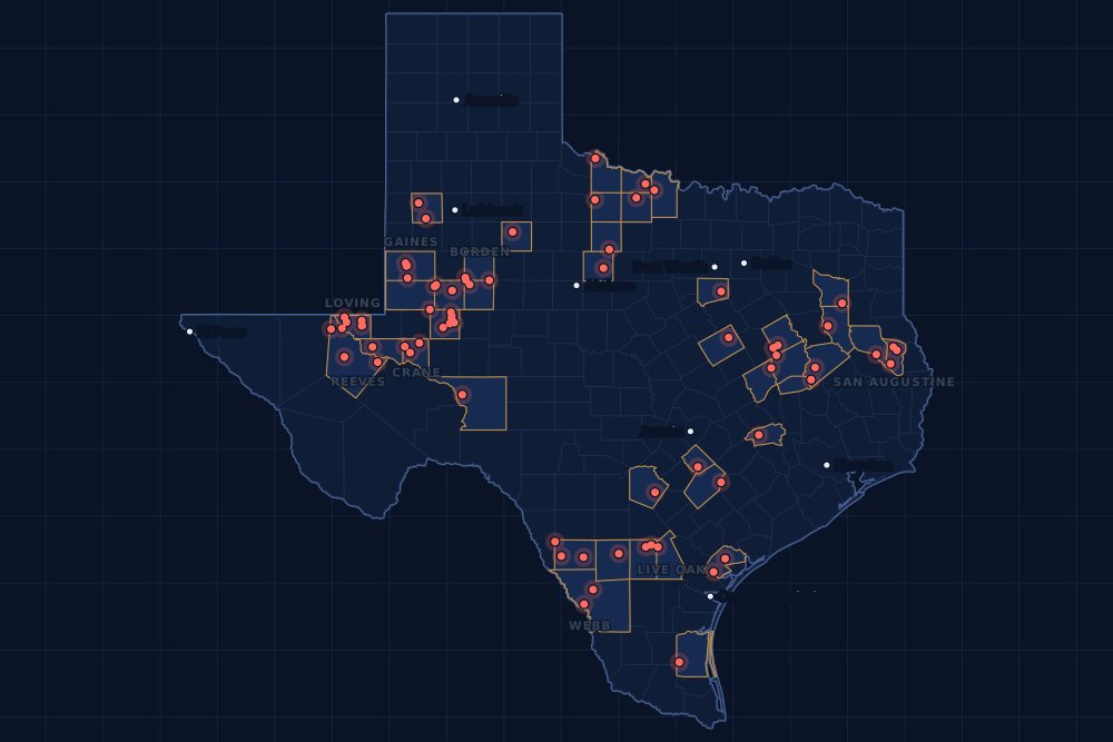
New Texas drilling permits, Jun 1–7, 2026
- 154permits issued
- 121horizontal
- 42counties
- 54operators
That week
Where the state permitted wells
Counties and operators
Who drills, and where
Each county links to its Well Watch page, with its own map and every permit of the last two years. Each operator links to its page.
By county
- 1Midland County28
- 2Loving County20
- 3Reeves County10
- 4Martin County9
- 5Dimmit County8
- 6San Augustine County8
- 7Andrews County6
- 8Gaines County6
- 9Borden County5
- 10Crane County5
- 11Live Oak County4
- 12Webb County4
- 13Howard County3
- 14Ward County3
- 15Freestone County2
And 27 more counties with fewer, in the list below.
By operator
- 1Pioneer Natural Res. USA, Inc.20
- 2Admiral Permian Operating LLC14
- 3Diamondback E&P LLC9
- 4Apex Natural Gas, LLC7
- 5Oxyrock Operating, LLC7
- 6Anadarko E&P Onshore LLC5
- 7OXY USA Inc.5
- 8Burlington Resources O & G Co LP4
- 9Enterprise Products Operatingllc4
- 10Fasken Oil and Ranch, Ltd.4
- 11Hilcorp Energy Company4
- 12Tarpon Resources, LP4
- 13Blackbeard Operating, LLC3
- 14Capitan Energy, Incorporated3
- 15Discovery Operating, Inc.3
And 39 more operators with fewer.
Register · June 1–7, 2026
Every permit, newest first
As the state files them: the lease and well, the operator, the kind of permit and the depth. “On the map” opens the county's live map at the well's spot.
Friday, June 536 permits
- Andrews CountyUl Dedham 45-31 B, well 2WDDiamondback E&P LLC · new drill · horizontal · 13,000 ftPermit 0916114 · API 42-003-49354On the map
- Andrews CountyUl Dedham 45-31 A, well 1WDDiamondback E&P LLC · new drill · horizontal · 13,000 ftPermit 0916113 · API 42-003-49353On the map
- Archer CountyMay Rutty A, well 3Lewis Operating Company · recompletion · vertical · 5,000 ftPermit 0916066 · API 42-009-42617On the map
- Bexar CountyCps LID24-SA-110, well 1Enterprise Products Operatingllc · new drill · vertical · 400 ftPermit 0915977 · API 42-029-38406On the map
- Caldwell CountyWright, J. D., well 7RLeft Behind Recovery, LLC · re-entry · vertical · 2,555 ftPermit 0915888 · API 42-055-04778On the map
- Freestone CountyGilliam 'B' No. 1 Gas Unit, well 14Hilcorp Energy Company · recompletion · vertical · 12,920 ftPermit 0916120 · API 42-161-33250On the map
- Gaines CountySeminole San Andres Unit, well 4019OXY USA Inc. · recompletion · vertical · 5,800 ftPermit 0916166 · API 42-165-32009On the map
- Gaines CountySeminole San Andres Unit, well 4019OXY USA Inc. · recompletion · vertical · 5,800 ftPermit 0916165 · API 42-165-32009On the map
- Gaines CountySeminole San Andres Unit, well 1412OXY USA Inc. · recompletion · vertical · 5,800 ftPermit 0916164 · API 42-165-32027On the map
- Gaines CountySeminole San Andres Unit, well 1412OXY USA Inc. · recompletion · vertical · 5,800 ftPermit 0916162 · API 42-165-32027On the map
- Gaines CountySeminole San Andres Unit, well 3810HOXY USA Inc. · new drill · horizontal · 6,000 ftPermit 0916121 · API 42-165-39027On the map
- Hockley CountyPink Houses SWD, well 1Beryl Oil and Gas, LP · new drill · vertical · 12,000 ftPermit 0916133 · API 42-219-37580On the map
- La Salle CountyPeter A, well 1HEOG Resources, Inc. · new drill · horizontal · 10,300 ftPermit 0916167 · API 42-283-37910On the map
- Live Oak CountyPlomero Ranch, well 48Burlington Resources O & G Co LP · new drill · horizontal · 17,500 ftPermit 0915779 · API 42-297-36578On the map
- Loving CountyStone Cutter K, well 751HEOG Resources, Inc. · new drill · horizontal · 14,000 ftPermit 0916155 · API 42-301-37882On the map
- Loving CountyLatrelle Unit, well 3WCAdmiral Permian Operating LLC · new drill · horizontal · 13,000 ftPermit 0915953 · API 42-301-37865On the map
- Loving CountyLatrelle Unit, well 2WCAdmiral Permian Operating LLC · new drill · horizontal · 13,000 ftPermit 0915951 · API 42-301-37864On the map
- Loving CountyLatrelle 1WC Unit, well 1WCAdmiral Permian Operating LLC · new drill · horizontal · 13,000 ftPermit 0915950 · API 42-301-37867On the map
- Loving CountyLatrelle 1WB Unit, well 1WBAdmiral Permian Operating LLC · new drill · horizontal · 12,700 ftPermit 0915949 · API 42-301-37866On the map
- Loving CountyLatrelle, well 1BSAdmiral Permian Operating LLC · new drill · horizontal · 12,000 ftPermit 0915943 · API 42-301-37862On the map
- Martin CountyUl Page 44-27 A, well 1WDDiamondback E&P LLC · new drill · horizontal · 13,000 ftPermit 0916117 · API 42-317-47314On the map
- Martin CountyMojave H, well 14HAOxyrock Operating, LLC · new drill · horizontal · 15,000 ftPermit 0915096 · API 42-317-47291On the map
- McLennan CountyCps SB-372.284, well 1Enterprise Products Operatingllc · new drill · vertical · 400 ftPermit 0915979 · API 42-309-30444On the map
- Midland CountyBuchanan-King 19H, well 8HPioneer Natural Res. USA, Inc. · new drill · horizontal · 10,414 ftPermit 0916189 · API 42-329-48440On the map
- Midland CountyBuchanan-King 19G, well 7HPioneer Natural Res. USA, Inc. · new drill · horizontal · 10,414 ftPermit 0916188 · API 42-329-48439On the map
- Midland CountyBuchanan-King 19E, well 5HPioneer Natural Res. USA, Inc. · new drill · horizontal · 10,414 ftPermit 0916187 · API 42-329-48438On the map
- Midland CountyBuchanan-King 19F, well 6HPioneer Natural Res. USA, Inc. · new drill · horizontal · 10,414 ftPermit 0916180 · API 42-329-48437On the map
- Midland CountyBuchanan-King 19D, well 4HPioneer Natural Res. USA, Inc. · new drill · horizontal · 10,414 ftPermit 0916176 · API 42-329-48436On the map
- Midland CountyBuchanan-King 19C, well 3HPioneer Natural Res. USA, Inc. · new drill · horizontal · 10,414 ftPermit 0916174 · API 42-329-48435On the map
- Midland CountyBuchanan-King 19B, well 2HPioneer Natural Res. USA, Inc. · new drill · horizontal · 10,414 ftPermit 0916142 · API 42-329-48432On the map
- Midland CountyBuchanan-King 19A, well 1HPioneer Natural Res. USA, Inc. · new drill · horizontal · 10,414 ftPermit 0916141 · API 42-329-48431On the map
- Reeves CountyJobe State 2-1 'A', well 5BHTarpon Resources, LP · new drill · horizontal · 13,500 ftPermit 0915478 · API 42-389-42139On the map
- Reeves CountyJobe State 2-1 'A', well 4WHTarpon Resources, LP · new drill · horizontal · 13,500 ftPermit 0915466 · API 42-389-42138On the map
- Reeves CountyJobe State 2-1 'A', well 3BHTarpon Resources, LP · new drill · horizontal · 13,500 ftPermit 0915465 · API 42-389-42131On the map
- Reeves CountyJobe State 2-1 'A', well 2WHTarpon Resources, LP · new drill · horizontal · 13,500 ftPermit 0915464 · API 42-389-42129On the map
- Refugio CountyRooke. B.d., well 6903PRising Star Energy Partners II, · new drill · vertical · 7,300 ftPermit 0916201 · API 42-391-33351On the map
Thursday, June 421 permits
- Baylor CountyWaggoner Swef, well 1681SWWaggoner Operating, L.L.C. · new drill · vertical · 7,000 ftPermit 0916112 · API 42-023-31871On the map
- Borden CountyCoyote Unit, well 411HFirebird Energy II LLC · new drill · horizontal · 8,325 ftPermit 0915970 · API 42-033-32848On the map
- Crane CountyWaddell Tr 1, well 5539HBlackbeard Operating, LLC · new drill · horizontal · 14,000 ftPermit 0916064 · API 42-103-37810On the map
- Loving CountyWalnut 55-1-46-3 F, well 72HAnadarko E&P Onshore LLC · new drill · horizontal · 13,000 ftPermit 0916041 · API 42-301-37880On the map
- Loving CountyWalnut 55-1-46-3 D, well 71HAnadarko E&P Onshore LLC · new drill · horizontal · 13,000 ftPermit 0916040 · API 42-301-37879On the map
- Martin CountyUl Comanche 42-28 C, well 3WDDiamondback E&P LLC · new drill · horizontal · 13,000 ftPermit 0915761 · API 42-317-47312On the map
- Martin CountyUl Comanche 42-28 B, well 2WDDiamondback E&P LLC · new drill · horizontal · 13,000 ftPermit 0915758 · API 42-317-47311On the map
- Midland CountyHugh Dixon 1, well 9RWOxyrock Operating, LLC · new drill · vertical · 7,500 ftPermit 0916247 · API 42-329-48442On the map
- Midland CountyBuchanan 42H, well 8HPioneer Natural Res. USA, Inc. · new drill · horizontal · 10,370 ftPermit 0916067 · API 42-329-48430On the map
- Reeves CountyAva State 36, well 8HCapitan Energy, Incorporated · new drill · horizontal · 9,670 ftPermit 0916111 · API 42-389-42165On the map
- Reeves CountyAva State 36, well 7HCapitan Energy, Incorporated · new drill · horizontal · 9,700 ftPermit 0916110 · API 42-389-42164On the map
- Reeves CountyAva State 36, well 6HCapitan Energy, Incorporated · new drill · horizontal · 9,725 ftPermit 0916109 · API 42-389-42163On the map
- San Augustine CountyTimberlands SWD, well 2Ventana Midstream LLC · new drill · vertical · 5,770 ftPermit 0916115 · API 42-405-30963On the map
- San Augustine CountyKingsley B Gas Unit, well 1HBApex Natural Gas, LLC · new drill · horizontal · 16,500 ftPermit 0915989 · API 42-405-30965On the map
- San Augustine CountyKingsley A Gas Unit, well 3HApex Natural Gas, LLC · new drill · horizontal · 16,500 ftPermit 0916004 · API 42-405-30967On the map
- San Augustine CountyKingsley A Gas Unit, well 2HBApex Natural Gas, LLC · new drill · horizontal · 16,500 ftPermit 0916003 · API 42-405-30966On the map
- San Augustine CountyKingsley A Gas Unit, well 1HApex Natural Gas, LLC · new drill · horizontal · 16,500 ftPermit 0915990 · API 42-405-30964On the map
- Ward CountyEast Elusive Jazz Bs 167-168, well 3TSManti Tarka Permian Op, LLC · new drill · horizontal · 10,600 ftPermit 0916137 · API 42-475-39077On the map
- Ward CountyEast Elusive Jazz Bs 167-168, well 2TSManti Tarka Permian Op, LLC · new drill · horizontal · 10,600 ftPermit 0916136 · API 42-475-39076On the map
- Ward CountyEast Elusive Jazz Bs 167-168, well 1TSManti Tarka Permian Op, LLC · new drill · horizontal · 10,600 ftPermit 0916135 · API 42-475-39075On the map
- Webb CountyWilson B, well 345HCaturus Energy, LLC · new drill · horizontal · 17,500 ftPermit 0916075 · API 42-479-45656On the map
Wednesday, June 355 permits
- Andrews CountyFee Bar F, well 4Fasken Oil and Ranch, Ltd. · new drill · horizontal · 12,200 ftPermit 0916081 · API 42-003-49348On the map
- Andrews CountyFee Bar F, well 3Fasken Oil and Ranch, Ltd. · new drill · horizontal · 12,200 ftPermit 0916080 · API 42-003-49347On the map
- Andrews CountyFee Bar F, well 2Fasken Oil and Ranch, Ltd. · new drill · horizontal · 12,300 ftPermit 0916079 · API 42-003-49346On the map
- Andrews CountyFee Bar F, well 1Fasken Oil and Ranch, Ltd. · new drill · horizontal · 12,300 ftPermit 0916078 · API 42-003-49345On the map
- Cherokee CountyMina, well 7Wmo Oil, LLC · new drill · vertical · 5,000 ftPermit 0916072 · API 42-073-31599On the map
- Crane CountyWaddell Tr 1, well 5738HBlackbeard Operating, LLC · new drill · horizontal · 14,000 ftPermit 0916065 · API 42-103-37811On the map
- Dimmit CountyComanche, well 9956HEl Toro Resources LLC · new drill · horizontal · 4,600 ftPermit 0916050 · API 42-127-39186On the map
- Dimmit CountyComanche, well 9955HEl Toro Resources LLC · new drill · horizontal · 4,600 ftPermit 0916046 · API 42-127-39185On the map
- Dimmit CountyBlakeway Unit I Dim, well 7HIneos USA Oil & Gas LLC · new drill · horizontal · 8,900 ftPermit 0915875 · API 42-127-39183On the map
- Dimmit CountyBlakeway Unit I Dim, well 5HIneos USA Oil & Gas LLC · new drill · horizontal · 8,900 ftPermit 0915874 · API 42-127-39182On the map
- Gaines CountyWharton, A.b.jr. 'A' Joa, well 133Bce-Mach III LLC · recompletion · vertical · 6,050 ftPermit 0915746 · API 42-165-32599On the map
- Hockley CountyFinley Estate, well 505WBurk Royalty Co., Ltd. · re-entry · vertical · 7,000 ftPermit 0916163 · API 42-219-31480On the map
- Houston CountyPatrick, well 1Walker Operating Company · new drill · vertical · 1,400 ftPermit 0916023 · API 42-225-31442On the map
- Johnson CountyThree Tracts, well 1Halliburton Energy Services, Inc · new drill · vertical · 65 ftPermit 0916101 · API 42-251-34599On the map
- Kent CountySalt Creek Field Unit, well F043OXY USA WTP LP · recompletion · horizontal · 7,200 ftPermit 0916012 · API 42-263-32154On the map
- Leon CountyGail King, well 15Hilcorp Energy Company · recompletion · vertical · 14,894 ftPermit 0916116 · API 42-289-31495On the map
- Live Oak CountyPlomero Ranch, well 49Burlington Resources O & G Co LP · new drill · horizontal · 17,500 ftPermit 0915780 · API 42-297-36579On the map
- Loving CountyCedar 55-1-46-3 H, well 61HAnadarko E&P Onshore LLC · new drill · horizontal · 13,000 ftPermit 0916043 · API 42-301-37881On the map
- Loving CountyWalnut 55-1-46-3 G, well 62HAnadarko E&P Onshore LLC · new drill · horizontal · 13,000 ftPermit 0916039 · API 42-301-37878On the map
- Loving CountyWalnut 55-1-46-3 E, well 61HAnadarko E&P Onshore LLC · new drill · horizontal · 13,000 ftPermit 0916037 · API 42-301-37869On the map
- Loving CountyRed Ryder Unit, well 302BCAdmiral Permian Operating LLC · new drill · horizontal · 11,800 ftPermit 0916035 · API 42-301-37877On the map
- Loving CountyRed Ryder Unit, well 301BCAdmiral Permian Operating LLC · new drill · horizontal · 11,800 ftPermit 0916034 · API 42-301-37876On the map
- Loving CountyRed Ryder Unit, well 205BSAdmiral Permian Operating LLC · new drill · horizontal · 11,100 ftPermit 0916031 · API 42-301-37875On the map
- Loving CountyRed Ryder Unit, well 204SHAdmiral Permian Operating LLC · new drill · horizontal · 11,000 ftPermit 0916029 · API 42-301-37874On the map
- Loving CountyRed Ryder Unit, well 203BSAdmiral Permian Operating LLC · new drill · horizontal · 11,000 ftPermit 0916022 · API 42-301-37873On the map
- Loving CountyRed Ryder Unit, well 202SHAdmiral Permian Operating LLC · new drill · horizontal · 11,000 ftPermit 0916021 · API 42-301-37872On the map
- Loving CountyRed Ryder Unit, well 201BSAdmiral Permian Operating LLC · new drill · horizontal · 11,100 ftPermit 0916020 · API 42-301-37871On the map
- Loving CountyRed Ryder Unit, well 102BSAdmiral Permian Operating LLC · new drill · horizontal · 10,500 ftPermit 0916019 · API 42-301-37870On the map
- Loving CountyRed Ryder Unit, well 101BSAdmiral Permian Operating LLC · new drill · horizontal · 10,500 ftPermit 0916018 · API 42-301-37868On the map
- Madison CountyW.m. Forrest D, well 2Empire Texas Operating LLC · recompletion · vertical · 10,605 ftPermit 0916100 · API 42-313-31015On the map
- Midland CountyJw X, well 1LSDiscovery Operating, Inc. · new drill · horizontal · 10,600 ftPermit 0916071 · API 42-329-48424On the map
- Midland CountyJw X, well 1WADiscovery Operating, Inc. · new drill · horizontal · 10,800 ftPermit 0916070 · API 42-329-48423On the map
- Midland CountyBuchanan 42G, well 7HPioneer Natural Res. USA, Inc. · new drill · horizontal · 10,370 ftPermit 0916063 · API 42-329-48429On the map
- Midland CountyBuchanan 42F, well 6HPioneer Natural Res. USA, Inc. · new drill · horizontal · 10,370 ftPermit 0916060 · API 42-329-48428On the map
- Midland CountyBuchanan 42E, well 5HPioneer Natural Res. USA, Inc. · new drill · horizontal · 10,370 ftPermit 0916059 · API 42-329-48427On the map
- Midland CountyBuchanan 42D, well 4HPioneer Natural Res. USA, Inc. · new drill · horizontal · 10,370 ftPermit 0916056 · API 42-329-48426On the map
- Midland CountyBuchanan 42C, well 3HPioneer Natural Res. USA, Inc. · new drill · horizontal · 10,370 ftPermit 0916054 · API 42-329-48425On the map
- Midland CountyBuchanan 42B, well 2HPioneer Natural Res. USA, Inc. · new drill · horizontal · 10,370 ftPermit 0916053 · API 42-329-45581On the map
- Midland CountyBuchanan 42A, well 1HPioneer Natural Res. USA, Inc. · new drill · horizontal · 10,370 ftPermit 0916052 · API 42-329-45578On the map
- Midland CountyGolladay-King 51O, well 15HPioneer Natural Res. USA, Inc. · new drill · horizontal · 10,373 ftPermit 0915885 · API 42-329-48402On the map
- Midland CountyGolladay-King 51D, well 4HPioneer Natural Res. USA, Inc. · new drill · horizontal · 10,373 ftPermit 0915884 · API 42-329-48401On the map
- Midland CountyJw L, well 2MSDiscovery Operating, Inc. · new drill · horizontal · 10,700 ftPermit 0915871 · API 42-329-48406On the map
- Midland CountyBerman 3-33 D, well 4BNDiamondback E&P LLC · new drill · horizontal · 13,000 ftPermit 0915263 · API 42-329-48353On the map
- Midland CountyBerman 3-33 C, well 3BNDiamondback E&P LLC · new drill · horizontal · 13,000 ftPermit 0915259 · API 42-329-48352On the map
- Midland CountyBerman 3-33 B, well 2BNDiamondback E&P LLC · new drill · horizontal · 13,000 ftPermit 0915256 · API 42-329-48351On the map
- Midland CountyBerman 3-33 A, well 1BNDiamondback E&P LLC · new drill · horizontal · 13,000 ftPermit 0915252 · API 42-329-48350On the map
- Robertson CountyCamp B, well 6HBAdamas Energy LLC · new drill · horizontal · 15,400 ftPermit 0916033 · API 42-395-32133On the map
- Robertson CountyCamp A, well 4HBAdamas Energy LLC · new drill · horizontal · 15,400 ftPermit 0916032 · API 42-395-32132On the map
- Shackelford CountySimpson, well 2Stasney Well Service, LLC · new drill · vertical · 990 ftPermit 0916082 · API 42-417-39834On the map
- Washington CountyGswf Bravo Aw, well 2HGeosouthern Operating II, LLC · new drill · horizontal · 13,500 ftPermit 0915734 · API 42-477-31340On the map
- Washington CountyGswf Alpha Aw, well 1HGeosouthern Operating II, LLC · new drill · horizontal · 13,500 ftPermit 0915674 · API 42-477-31339On the map
- Webb CountyWilson A, well 140HCaturus Energy, LLC · new drill · horizontal · 17,500 ftPermit 0916074 · API 42-479-45655On the map
- Webb CountyLaurel Sa C, well 1004HLewis Petro Properties, Inc. · new drill · horizontal · 12,000 ftPermit 0916002 · API 42-479-45654On the map
- Webb CountyLaurel Sa B, well 500HLewis Petro Properties, Inc. · new drill · horizontal · 12,000 ftPermit 0916001 · API 42-479-45653On the map
- Wilbarger CountyKester SWD, well 1Jamex, Inc. · new drill · vertical · 6,000 ftPermit 0916057 · API 42-487-33426On the map
Tuesday, June 222 permits
- Borden CountyCoyote Unit, well 410HFirebird Energy II LLC · new drill · horizontal · 8,225 ftPermit 0915964 · API 42-033-32846On the map
- Borden CountyCoyote Unit, well 409HFirebird Energy II LLC · new drill · horizontal · 8,325 ftPermit 0915961 · API 42-033-32845On the map
- Borden CountyBanner East, well 14HPetroplex Energy Inc. · new drill · horizontal · 9,000 ftPermit 0914555 · API 42-033-32833On the map
- Clay CountySB1-MP 199.571, well 1Enterprise Products Operatingllc · new drill · vertical · 400 ftPermit 0915654 · API 42-077-35425On the map
- Crane CountySandhills Orbit T, well 1XHRing Energy, Inc. · new drill · horizontal · 4,825 ftPermit 0915993 · API 42-103-37809On the map
- Crockett CountyEagle Draw '11', well 1Walsh & Watts, Inc. · recompletion · horizontal · 5,904 ftPermit 0915411 · API 42-105-38575On the map
- Dimmit CountyTocquigny Sm, well 604HAtlas Operating LLC · new drill · horizontal · 3,800 ftPermit 0915976 · API 42-127-39184On the map
- Dimmit CountyTocquigny Sm, well 603HAtlas Operating LLC · new drill · horizontal · 3,800 ftPermit 0915975 · API 42-127-39180On the map
- Dimmit CountyBlakeway Unit I Dim, well 4HIneos USA Oil & Gas LLC · new drill · horizontal · 8,900 ftPermit 0915873 · API 42-127-39181On the map
- Gonzales CountyMunson Ranch, well 22HFW Eagle Ford I, LLC · new drill · horizontal · 14,500 ftPermit 0915952 · API 42-177-34834On the map
- Gonzales CountyMunson Ranch, well 16HFW Eagle Ford I, LLC · new drill · horizontal · 14,500 ftPermit 0915948 · API 42-177-34833On the map
- Kenedy CountySanta Fe Julian Pasture, well 5Abaco Operating, LLC · new drill · vertical · 9,500 ftPermit 0916014 · API 42-261-31629On the map
- McMullen CountyPeeler, well 1Shore Petroleum Corp. · new drill · vertical · 6,200 ftPermit 0915974 · API 42-311-37686On the map
- Midland CountyMcalister-Golladay 41D, well 4HPioneer Natural Res. USA, Inc. · new drill · horizontal · 10,391 ftPermit 0915349 · API 42-329-48359On the map
- Midland CountyMcalister-Golladay 41C, well 3HPioneer Natural Res. USA, Inc. · new drill · horizontal · 10,391 ftPermit 0915348 · API 42-329-48358On the map
- Reeves CountyCortado 1604A, well 01HContinental Resources, Inc. · new drill · horizontal · 14,794 ftPermit 0916027 · API 42-389-42162On the map
- Reeves CountyBrick Unit, well 2THU.S. Energy Development Corp · new drill · horizontal · 12,000 ftPermit 0915848 · API 42-389-42159On the map
- San Augustine CountyLister F, well 7HBApex Natural Gas, LLC · new drill · horizontal · 14,500 ftPermit 0915929 · API 42-405-30961On the map
- San Augustine CountyWalters D, well 4HApex Natural Gas, LLC · new drill · horizontal · 14,500 ftPermit 0915921 · API 42-405-30960On the map
- San Augustine CountyWalters C, well 3HBApex Natural Gas, LLC · new drill · horizontal · 14,500 ftPermit 0915916 · API 42-405-30959On the map
- Smith CountyKickapoo Creek Gas Unit, well 6Faulconer Energy, LLC · recompletion · vertical · 11,770 ftPermit 0915496 · API 42-423-31648On the map
- Wichita CountySB1-MP 187.432, well 1Enterprise Products Operatingllc · new drill · vertical · 400 ftPermit 0915644 · API 42-485-46431On the map
Monday, June 120 permits
- Borden CountyWolf Ranches 40-45 B Unit, well M 7HHighpeak Energy Holdings, LLC · new drill · horizontal · 6,500 ftPermit 0916083 · API 42-033-32847On the map
- Crane CountySandhills Orbit M, well 1XHRing Energy, Inc. · new drill · horizontal · 3,750 ftPermit 0915960 · API 42-103-37808On the map
- Crane CountyBilly Bones, well 4Blackbeard Operating, LLC · recompletion · vertical · 6,388 ftPermit 0915956 · API 42-103-37314On the map
- Dimmit CountyComanche, well 9954HEl Toro Resources LLC · new drill · horizontal · 5,000 ftPermit 0915907 · API 42-127-39179On the map
- Freestone CountyKnight Gas Unit No. 1, well 2Hilcorp Energy Company · recompletion · vertical · 13,105 ftPermit 0915764 · API 42-161-32395On the map
- Howard CountyEvans-Antell Unit B 46-03, well 4MHSurge Operating, LLC · new drill · horizontal · 9,000 ftPermit 0915972 · API 42-227-42899On the map
- Howard CountyEvans-Antell Unit B 46-03, well 4CHSurge Operating, LLC · new drill · horizontal · 9,000 ftPermit 0915971 · API 42-227-42898On the map
- Howard CountyEvans-Antell Unit B 46-03, well 3MHSurge Operating, LLC · new drill · horizontal · 9,000 ftPermit 0915969 · API 42-227-42897On the map
- Live Oak CountyPlomero Ranch, well 51Burlington Resources O & G Co LP · new drill · horizontal · 17,500 ftPermit 0915782 · API 42-297-36581On the map
- Live Oak CountyPlomero Ranch, well 50Burlington Resources O & G Co LP · new drill · horizontal · 17,500 ftPermit 0915781 · API 42-297-36580On the map
- Martin CountyMojave F, well 11MSOxyrock Operating, LLC · new drill · horizontal · 15,000 ftPermit 0915095 · API 42-317-47290On the map
- Martin CountyMojave F, well 10HBOxyrock Operating, LLC · new drill · horizontal · 15,000 ftPermit 0915094 · API 42-317-47289On the map
- Martin CountyMojave F, well 9DNOxyrock Operating, LLC · new drill · horizontal · 15,000 ftPermit 0915093 · API 42-317-47288On the map
- Martin CountyMojave F, well 8HAOxyrock Operating, LLC · new drill · horizontal · 15,000 ftPermit 0915092 · API 42-317-47287On the map
- Martin CountyMojave E, well 6DNOxyrock Operating, LLC · new drill · horizontal · 15,000 ftPermit 0915091 · API 42-317-47286On the map
- McMullen CountySwaim, well 2Kaler Energy Corp. · new drill · vertical · 6,500 ftPermit 0915908 · API 42-311-37685On the map
- Nacogdoches CountyHawk Ridge, well 1HRevenant Energy Operating LLC · new drill · horizontal · 16,500 ftPermit 0915135 · API 42-347-33546On the map
- Reeves CountyBrick Unit, well 1THU.S. Energy Development Corp · new drill · horizontal · 12,000 ftPermit 0915847 · API 42-389-42158On the map
- Refugio CountyTom O'Connor (5800 Sd) Fld. Unit, well 125Hilcorp Energy Company · new drill · vertical · 6,115 ftPermit 0915665 · API 42-391-33345On the map
- Throckmorton CountyWbrr 233, well 113Okie Operating Company, Ltd. · new drill · vertical · 999 ftPermit 0915944 · API 42-447-36870On the map
Cancelled permits are left out. To look a permit up at the source, use the Railroad Commission's drilling permit query with its permit number.
Archive
Earlier weeks
Each finished week, Monday to Sunday, has its own page that does not change. The feed gets one entry per week.
- Nov 9–15, 2026103
- Nov 2–8, 2026164
- Oct 26 – Nov 1, 2026242
- Oct 19–25, 2026215
- Oct 12–18, 2026147
- Oct 5–11, 2026152
- Sep 28 – Oct 4, 2026156
- Sep 21–27, 2026194
- Sep 14–20, 2026167
- Sep 7–13, 2026133
- Aug 31 – Sep 6, 2026182
- Aug 24–30, 2026118
Every week since January 1, 2024 (150 weeks)
2026
- Aug 17–23167
- Aug 10–16198
- Aug 3–9186
- Jul 27 – Aug 2143
- Jul 20–26170
- Jul 13–19117
- Jul 6–12194
- Jun 29 – Jul 5114
- Jun 22–28175
- Jun 15–21186
- Jun 8–14187
- Jun 1–7154
- May 25–31158
- May 18–24197
- May 11–17182
- May 4–10190
- Apr 27 – May 3156
- Apr 20–26210
- Apr 13–19133
- Apr 6–12206
- Mar 30 – Apr 5129
- Mar 23–29159
- Mar 16–22167
- Mar 9–15166
- Mar 2–8140
- Feb 23 – Mar 1181
- Feb 16–22141
- Feb 9–15133
- Feb 2–8124
- Jan 26 – Feb 1126
- Jan 19–25189
- Jan 12–18280
- Jan 5–11129
2025
- Dec 29 – Jan 4, 202656
- Dec 22–2846
- Dec 15–21154
- Dec 8–14119
- Dec 1–7128
- Nov 24–3061
- Nov 17–23140
- Nov 10–1698
- Nov 3–9107
- Oct 27 – Nov 2137
- Oct 20–26145
- Oct 13–19173
- Oct 6–12206
- Sep 29 – Oct 5124
- Sep 22–28141
- Sep 15–21165
- Sep 8–14127
- Sep 1–7105
- Aug 25–31145
- Aug 18–24115
- Aug 11–17140
- Aug 4–10131
- Jul 28 – Aug 3134
- Jul 21–27151
- Jul 14–20151
- Jul 7–13148
- Jun 30 – Jul 6148
- Jun 23–29167
- Jun 16–22118
- Jun 9–15115
- Jun 2–8147
- May 26 – Jun 190
- May 19–25148
- May 12–18120
- May 5–11114
- Apr 28 – May 4135
- Apr 21–27182
- Apr 14–20115
- Apr 7–13197
- Mar 31 – Apr 6194
- Mar 24–30170
- Mar 17–23189
- Mar 10–16177
- Mar 3–9141
- Feb 24 – Mar 2172
- Feb 17–23145
- Feb 10–16170
- Feb 3–9167
- Jan 27 – Feb 2149
- Jan 20–26158
- Jan 13–19176
- Jan 6–12140
2024
- Dec 30 – Jan 5, 202597
- Dec 23–295
- Dec 16–22168
- Dec 9–15202
- Dec 2–8182
- Nov 25 – Dec 189
- Nov 18–24189
- Nov 11–17145
- Nov 4–10152
- Oct 28 – Nov 3134
- Oct 21–27163
- Oct 14–20147
- Oct 7–13114
- Sep 30 – Oct 6138
- Sep 23–29133
- Sep 16–22175
- Sep 9–15144
- Sep 2–8138
- Aug 26 – Sep 1177
- Aug 19–25207
- Aug 12–18186
- Aug 5–11145
- Jul 29 – Aug 4191
- Jul 22–28174
- Jul 15–21164
- Jul 8–14205
- Jul 1–7106
- Jun 24–30183
- Jun 17–23192
- Jun 10–16161
- Jun 3–9176
- May 27 – Jun 2135
- May 20–26223
- May 13–19169
- May 6–12155
- Apr 29 – May 5191
- Apr 22–28224
- Apr 15–21200
- Apr 8–14157
- Apr 1–7149
- Mar 25–31102
- Mar 18–24130
- Mar 11–17228
- Mar 4–10178
- Feb 26 – Mar 3187
- Feb 19–25164
- Feb 12–18190
- Feb 5–11137
- Jan 29 – Feb 4177
- Jan 22–28172
- Jan 15–21107
- Jan 8–14251
- Jan 1–7148
FAQ
Questions people ask
What is a drilling permit?
Permission from the Railroad Commission of Texas to drill a well, or to re-enter or deepen an old one, at a stated spot and to a stated depth. An operator files for it before the rig comes; it lasts two years. Many permitted wells are drilled within months, some never are.
Is this week complete?
Yes. The state has issued permits on later days, so this week's list is closed. A permit the state cancels later drops off the list.
Some permits are not on the map. Why?
The map draws a permit at the well's surface location as the state files it. A new permit's location can take a few days to reach the state's files; until then it is listed here but not drawn.
Does a new permit near my land mean I will be paid?
No. A permit says where a well may be drilled, not whose minerals it will produce or who is paid. That depends on your lease, the unit the well is pooled in and the division order. If a well is drilled on or next to your tract, watch for a division order from the operator.
Can I get these by email or in a feed?
Yes. The feed on this page has one entry for each finished week, for any feed reader. For one county, an abstract or a lease, Texas Well Watch sends one email a week when the state files something new there; it is free with an account.
Sources
- Railroad Commission of Texas, drilling permit master and trailer, daily file (with latitudes and longitudes)www.rrc.texas.gov/resource-center/research/data-sets-available-for-download/ · loaded every night; newest permit on file November 20, 2026
- Railroad Commission of Texas, drilling permit query (one permit at the source)webapps.rrc.texas.gov/DP/initializePublicQueryAction.do · linked, not read
- US Census Bureau, cartographic boundary files (county lines), through the us-atlas package 3.0.1www.census.gov/geographies/mapping-files/time-series/geo/cartographic-boundary.html · built into the site with its well maps
- GeoNames, towns and their points (CC BY 4.0)www.geonames.org/ · built into the site with its town pages