
Railroad Commission of Texas · week of January 8, 2024
New Texas drilling permits, Jan 8–14, 2024
- 251permits issued
- 200horizontal
- 49counties
- 68operators
That week
Where the state permitted wells
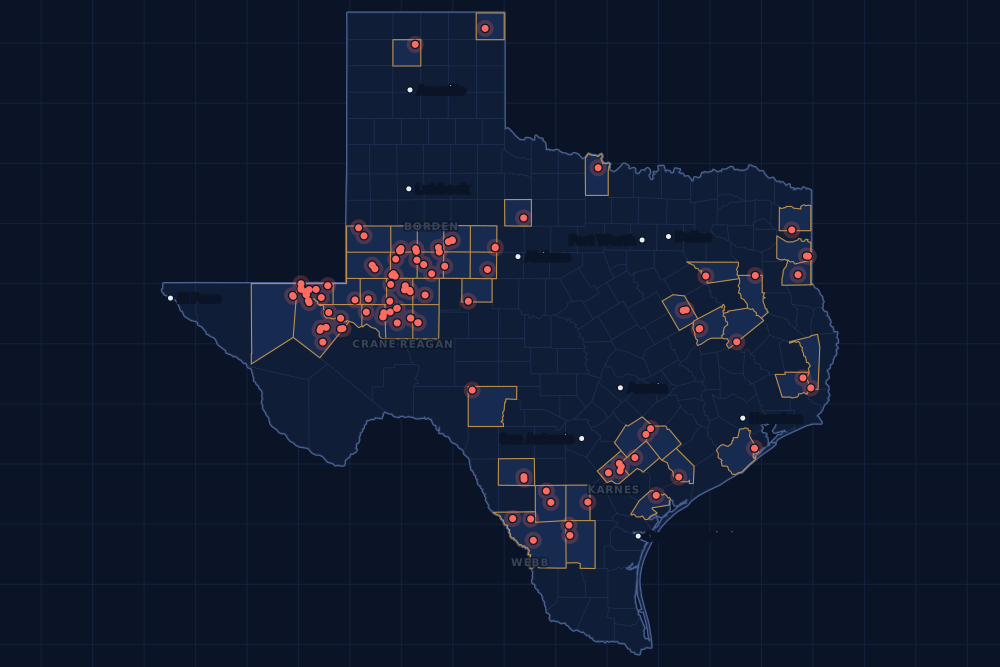
Counties and operators
Who drills, and where
Each county links to its Well Watch page, with its own map and every permit of the last two years. Each operator links to its page.
By county
- 1Upton County37
- 2Midland County23
- 3Loving County21
- 4Reeves County20
- 5Karnes County15
- 6Martin County13
- 7Webb County11
- 8Howard County9
- 9Crane County7
- 10Ward County7
- 11Dawson County6
- 12Borden County5
- 13Harrison County5
- 14Reagan County5
- 15Scurry County5
And 34 more counties with fewer, in the list below.
By operator
- 1Pioneer Natural Res. USA, Inc.27
- 2De IV Operating, LLC23
- 3Diamondback E&P LLC17
- 4Burlington Resources O & G Co LP9
- 5Highpeak Energy Holdings, LLC9
- 6Wes Water Holdings LLC8
- 7Silverbow Resources Oper, LLC7
- 8Admiral Permian Operating LLC6
- 9Earthstone Operating, LLC6
- 10Marathon Oil Ef LLC6
- 11Atmos Energy Corp., Mid-Tex Div.5
- 12Civitas Permian Operating, LLC5
- 13Kinder Morgan Production Co LLC5
- 14Ovintiv USA Inc.5
- 15Rocc Oil & Gas, L.P.5
And 53 more operators with fewer.
Register · January 8–14, 2024
Every permit, newest first
As the state files them: the lease and well, the operator, the kind of permit and the depth. “On the map” opens the county's live map at the well's spot.
Friday, January 1257 permits
- Borden CountyWolf Ranches 40-45 B Unit, well L 6HHighpeak Energy Holdings, LLC · new drill · horizontal · 6,000 ftPermit 0896447 · API 42-033-32677On the map
- Borden CountyWolf Ranches 40-45 B Unit, well A 6HHighpeak Energy Holdings, LLC · new drill · horizontal · 6,400 ftPermit 0896446 · API 42-033-32676On the map
- Borden CountyWolf Ranches 40-45 B Unit, well L 5HHighpeak Energy Holdings, LLC · new drill · horizontal · 6,000 ftPermit 0896444 · API 42-033-32675On the map
- Borden CountyWolf Ranches 40-45 B Unit, well A 5HHighpeak Energy Holdings, LLC · new drill · horizontal · 6,400 ftPermit 0896443 · API 42-033-32674On the map
- Borden CountyLaurel 84-89 B Unit, well A 5HHighpeak Energy Holdings, LLC · new drill · horizontal · 6,800 ftPermit 0896442 · API 42-033-32673On the map
- Cherokee CountyMcgill-Burke A (Aw), well 1HSabine Oil & Gas Corporation · new drill · horizontal · 13,000 ftPermit 0896405 · API 42-073-31593On the map
- Coke CountyTdr Trinity, well 1HSixess Energy, LLC · new drill · horizontal · 8,000 ftPermit 0896162 · API 42-081-32141On the map
- Crane CountyNorth Mcelroy Unit, well 4523FHAvad Operating, LLC · recompletion · horizontal · 6,000 ftPermit 0896376 · API 42-103-35070On the map
- Crane CountyWaddell Tr A, well 4089HBlackbeard Operating, LLC · new drill · horizontal · 7,999 ftPermit 0895263 · API 42-103-37386On the map
- Culberson CountyF C SWD E, well 5Saturn SWD Operating LLC · new drill · vertical · 6,000 ftPermit 0896495 · API 42-109-33740On the map
- Culberson CountyF C SWD B, well 2Saturn SWD Operating LLC · new drill · vertical · 6,000 ftPermit 0896493 · API 42-109-33727On the map
- Culberson CountyScott Fee 36, well 8HCapitan Energy, Incorporated · new drill · horizontal · 12,000 ftPermit 0896489 · API 42-109-34189On the map
- Culberson CountyScott Fee 36, well 7HCapitan Energy, Incorporated · new drill · horizontal · 12,000 ftPermit 0896488 · API 42-109-34188On the map
- Dawson CountyGhost 35-26 C, well 6DNBirch Operations, Inc. · new drill · horizontal · 8,500 ftPermit 0896374 · API 42-115-33958On the map
- Duval CountyDcr 152A, well 16Killam Oil Co., Ltd. · recompletion · vertical · 1,000 ftPermit 0896445 · API 42-131-39369On the map
- Fisher CountyWelch, well 19L.c.s. Production Company · new drill · vertical · 5,990 ftPermit 0896474 · API 42-151-33352On the map
- Fisher CountyNorth Wickham, well 4RL.c.s. Production Company · re-entry · vertical · 4,960 ftPermit 0896373 · API 42-151-32306On the map
- Gaines CountySeminole San Andres Unit, well 1103OXY USA Inc. · recompletion · vertical · 5,650 ftPermit 0896436 · API 42-165-31905On the map
- Hardin CountyElliot, F.p. Fee, well 15Foundation Energy Management LLC · new drill · vertical · 8,200 ftPermit 0896387 · API 42-199-33656On the map
- Harrison CountyT.p. Smith Hv Unit E, well 5HRockcliff Energy Operating LLC · new drill · horizontal · 13,000 ftPermit 0896380 · API 42-203-35643On the map
- Jackson CountyWest Ranch -A-, well 378Hilcorp Energy Company · recompletion · vertical · 6,303 ftPermit 0896448 · API 42-239-02725On the map
- Karnes CountyTipton-Jonas Unit, well 505HMarathon Oil Ef LLC · new drill · horizontal · 22,000 ftPermit 0896486 · API 42-255-37957On the map
- Karnes CountyTipton-Jonas Unit, well 503HMarathon Oil Ef LLC · new drill · horizontal · 22,000 ftPermit 0896485 · API 42-255-37956On the map
- Karnes CountyTipton-Jonas Unit, well 502HMarathon Oil Ef LLC · new drill · horizontal · 22,000 ftPermit 0896484 · API 42-255-37955On the map
- Loving CountyDbm 54-1-40, well 1DWes Water Holdings LLC · new drill · vertical · 7,100 ftPermit 0896465 · API 42-301-36724On the map
- Loving CountyEl Campeon South Fed Com, well 431HEarthstone Operating, LLC · new drill · horizontal · 13,300 ftPermit 0896194 · API 42-301-36723No location yet
- Loving CountyEl Campeon South Fed Com, well 511HEarthstone Operating, LLC · new drill · horizontal · 13,600 ftPermit 0896193 · API 42-301-36722No location yet
- Loving CountyLos Vaqueros Unit 3, well 463HEarthstone Operating, LLC · new drill · horizontal · 13,300 ftPermit 0896085 · API 42-301-36691No location yet
- Loving CountyEl Campeon South Fed Com, well 401HEarthstone Operating, LLC · new drill · horizontal · 13,200 ftPermit 0896064 · API 42-301-36693No location yet
- Loving CountyLos Vaqueros Unit 3, well 523HEarthstone Operating, LLC · new drill · horizontal · 13,600 ftPermit 0896062 · API 42-301-36690No location yet
- Loving CountyLos Vaqueros Unit 3, well 443HEarthstone Operating, LLC · new drill · horizontal · 13,200 ftPermit 0896060 · API 42-301-36689No location yet
- Martin CountyCorsica SWD 2, well 2Stonehill Martin, LLC · new drill · vertical · 5,300 ftPermit 0896499 · API 42-317-45827On the map
- Martin CountyEast Cross Bar Ranch, well 1894OPOccidental Permian Ltd. · new drill · horizontal · 13,000 ftPermit 0896463 · API 42-317-45829On the map
- Nolan CountyDavis 'A', well 1Goodrock Natural Resources, LLC · recompletion · vertical · 5,800 ftPermit 0896457 · API 42-353-32464On the map
- Reagan CountyHolly K, well 12HCivitas Permian Operating, LLC · new drill · horizontal · 11,000 ftPermit 0895948 · API 42-383-41663On the map
- Reagan CountyHolly G, well 8HCivitas Permian Operating, LLC · new drill · horizontal · 11,000 ftPermit 0895944 · API 42-383-41634On the map
- Reagan CountyHolly C, well 3HCivitas Permian Operating, LLC · new drill · horizontal · 11,000 ftPermit 0895939 · API 42-383-41631On the map
- Reagan CountyHolly A, well 2HCivitas Permian Operating, LLC · new drill · horizontal · 11,000 ftPermit 0895938 · API 42-383-41630On the map
- Reagan CountyHolly A, well 1HCivitas Permian Operating, LLC · new drill · horizontal · 11,000 ftPermit 0895937 · API 42-383-41638On the map
- Reeves CountyDbm 55-3-3, well 1DWes Water Holdings LLC · new drill · vertical · 6,250 ftPermit 0896466 · API 42-389-41011On the map
- Reeves CountyElizabeth G, well 1BVital Energy, Inc. · new drill · horizontal · 11,000 ftPermit 0896397 · API 42-389-41006On the map
- Reeves CountyDoc Seuss A, well 331HPermian Resources Operating, LLC · new drill · horizontal · 11,700 ftPermit 0895877 · API 42-389-40962On the map
- Refugio CountyO'Connor, well 101T-C Oil Company, LLC · recompletion · vertical · 5,930 ftPermit 0896429 · API 42-391-33309On the map
- Refugio CountyO'Connor, well 92T-C Oil Company, LLC · recompletion · vertical · 5,906 ftPermit 0896428 · API 42-391-33251On the map
- Upton CountyPembrook 4, well 10HPioneer Natural Res. USA, Inc. · new drill · horizontal · 10,491 ftPermit 0896478 · API 42-461-42681On the map
- Upton CountyPembrook 4, well 9HPioneer Natural Res. USA, Inc. · new drill · horizontal · 10,491 ftPermit 0896477 · API 42-461-42680On the map
- Upton CountyPembrook 4, well 8HPioneer Natural Res. USA, Inc. · new drill · horizontal · 10,491 ftPermit 0896476 · API 42-461-42679On the map
- Upton CountyPembrook 4, well 6HPioneer Natural Res. USA, Inc. · new drill · horizontal · 10,491 ftPermit 0896427 · API 42-461-42677On the map
- Upton CountyPembrook 4, well 5HPioneer Natural Res. USA, Inc. · new drill · horizontal · 10,491 ftPermit 0896426 · API 42-461-42676On the map
- Upton CountyPembrook 4, well 4HPioneer Natural Res. USA, Inc. · new drill · horizontal · 10,491 ftPermit 0896425 · API 42-461-42675On the map
- Upton CountyPembrook 4, well 3HPioneer Natural Res. USA, Inc. · new drill · horizontal · 10,491 ftPermit 0896424 · API 42-461-42674On the map
- Upton CountyPembrook 4, well 2HPioneer Natural Res. USA, Inc. · new drill · horizontal · 10,491 ftPermit 0896423 · API 42-461-42673On the map
- Upton CountyCindy 2413A, well 301HFirebird Energy II LLC · new drill · horizontal · 8,800 ftPermit 0896418 · API 42-461-42685On the map
- Upton CountyCindy 2413A, well 101HFirebird Energy II LLC · new drill · horizontal · 10,600 ftPermit 0896417 · API 42-461-42684On the map
- Upton CountyCindy 2413A, well 501HFirebird Energy II LLC · new drill · horizontal · 9,600 ftPermit 0896416 · API 42-461-42683On the map
- Winkler CountySpanish Main E, well 319HBlackbeard Operating, LLC · new drill · horizontal · 7,999 ftPermit 0896480 · API 42-495-34939On the map
- Zavala CountyWilson-Gates B-Holdsworth (Aw), well 1HBuffco Production Inc. · new drill · horizontal · 12,000 ftPermit 0896430 · API 42-507-33529On the map
Thursday, January 1131 permits
- Crane CountyNorth Mcelroy Unit, well 3949FHAvad Operating, LLC · recompletion · horizontal · 6,000 ftPermit 0896378 · API 42-103-34719On the map
- Crane CountyNorth Mcelroy Unit, well 4511RHAvad Operating, LLC · recompletion · horizontal · 6,000 ftPermit 0896377 · API 42-103-35358On the map
- Crane CountyNorth Mcelroy Unit, well 4514FHAvad Operating, LLC · recompletion · horizontal · 6,000 ftPermit 0896375 · API 42-103-35071On the map
- Crane CountyUl Lonetree 22303 B 23-26, well 6HBTA Oil Producers, LLC · new drill · horizontal · 10,213 ftPermit 0896137 · API 42-103-37422On the map
- Crane CountyUl Lonetree 22303 A 23-26, well 5HBTA Oil Producers, LLC · new drill · horizontal · 10,213 ftPermit 0896136 · API 42-103-37421On the map
- Dawson CountyO'Brien SWD, well 3Deep Blue Central LLC · new drill · vertical · 5,400 ftPermit 0896464 · API 42-115-33962On the map
- Dawson CountyO'Brien SWD, well 2Deep Blue Central LLC · new drill · vertical · 5,400 ftPermit 0896462 · API 42-115-33961On the map
- Dawson CountyO'Brien SWD, well 1Deep Blue Central LLC · new drill · vertical · 5,400 ftPermit 0896461 · API 42-115-33960On the map
- Fisher CountyWelch, well 16L.c.s. Production Company · new drill · vertical · 5,990 ftPermit 0896408 · API 42-151-33351On the map
- Gonzales CountyHyperion B, well 2HRocc Oil & Gas, L.P. · new drill · horizontal · 14,500 ftPermit 0896399 · API 42-177-34674On the map
- Gonzales CountyHyperion A, well 1HRocc Oil & Gas, L.P. · new drill · horizontal · 14,500 ftPermit 0896398 · API 42-177-34673On the map
- Harrison CountyT.p. Smith Hv Unit G, well 7HRockcliff Energy Operating LLC · new drill · horizontal · 13,000 ftPermit 0896382 · API 42-203-35645On the map
- Harrison CountyT.p. Smith Hv Unit F, well 6HRockcliff Energy Operating LLC · new drill · horizontal · 13,000 ftPermit 0896381 · API 42-203-35644On the map
- Howard CountyZion 15G, well 5HFOvintiv USA Inc. · new drill · horizontal · 9,800 ftPermit 0896293 · API 42-227-42366On the map
- Karnes CountySchendel-Reynolds SA1, well 1HMarathon Oil Ef LLC · new drill · horizontal · 22,000 ftPermit 0896187 · API 42-255-37935On the map
- Lavaca CountyPluto D, well 4HRocc Oil & Gas, L.P. · new drill · horizontal · 14,500 ftPermit 0896412 · API 42-285-34281On the map
- Lavaca CountyPluto C, well 3HBaytex Energy USA, Inc. · new drill · horizontal · 14,500 ftPermit 0896411 · API 42-285-34280On the map
- Lavaca CountyPluto B, well 2HRocc Oil & Gas, L.P. · new drill · horizontal · 14,500 ftPermit 0896410 · API 42-285-34279On the map
- Lavaca CountyPluto A, well 1HRocc Oil & Gas, L.P. · new drill · horizontal · 14,500 ftPermit 0896409 · API 42-285-34278On the map
- Loving CountyWhite Oak 53-2 B, well 4572HPDEH LLC · new drill · horizontal · 13,000 ftPermit 0895262 · API 42-301-36658On the map
- Martin CountySmuggler 3, well 2005HRFourpoint Energy, LLC · new drill · horizontal · 10,500 ftPermit 0896502 · API 42-317-45826On the map
- Martin CountySouth Curtis Ranch, well 2611KPOccidental Permian Ltd. · recompletion · horizontal · 12,000 ftPermit 0896261 · API 42-317-45176On the map
- Midland CountyBusby, well 5HBApache Corporation · new drill · horizontal · 12,000 ftPermit 0896422 · API 42-329-46769On the map
- Reeves CountyLucy Prewit B, well 334HPermian Resources Operating, LLC · new drill · horizontal · 11,700 ftPermit 0895927 · API 42-389-40975On the map
- Reeves CountyLucy Prewit A, well 333HPermian Resources Operating, LLC · new drill · horizontal · 11,700 ftPermit 0895926 · API 42-389-40966On the map
- Reeves CountySharktooth 3-4, well 9TBDiamondback E&P LLC · new drill · horizontal · 13,000 ftPermit 0895874 · API 42-389-40960On the map
- Upton CountyNeff East G 9-45, well 2615HDiamondback E&P LLC · new drill · horizontal · 8,547 ftPermit 0896343 · API 42-461-42671On the map
- Ward CountyWhirlaway 101-99 B, well 2TSDiamondback E&P LLC · new drill · horizontal · 11,130 ftPermit 0895645 · API 42-475-38720On the map
- Ward CountyHornsilver, well 2HHalcon Operating Co., Inc. · new drill · horizontal · 12,500 ftPermit 0895086 · API 42-475-38705On the map
- Webb CountyBrannan, well 1EOG Resources, Inc. · new drill · vertical · 6,000 ftPermit 0896413 · API 42-479-45083On the map
- Webb CountyPge Dos, well E 12HSilverbow Resources Oper, LLC · new drill · horizontal · 9,000 ftPermit 0896304 · API 42-479-45075On the map
Wednesday, January 1045 permits
- Cass CountyGraham, well 1Rose City Resources, LLC · new drill · vertical · 13,000 ftPermit 0896385 · API 42-067-30930On the map
- Cherokee CountyMcgill-Murphy B (Aw), well 2HSabine Oil & Gas Corporation · new drill · horizontal · 13,000 ftPermit 0896404 · API 42-073-31592On the map
- De Witt CountyMoc A-Moc B Sa 5, well 5HBPX Operating Company · new drill · horizontal · 14,000 ftPermit 0896372 · API 42-123-35361On the map
- De Witt CountyMoc A-Moc B Sa 4, well 4HBPX Operating Company · new drill · horizontal · 14,000 ftPermit 0896371 · API 42-123-35360On the map
- De Witt CountyMoc A-Moc B Sa 3, well 3HBPX Operating Company · new drill · horizontal · 14,000 ftPermit 0896370 · API 42-123-35359On the map
- De Witt CountyGaida A-Moc B Sa 2, well 2HBPX Operating Company · new drill · horizontal · 14,000 ftPermit 0896367 · API 42-123-35358On the map
- Howard CountySt George 33-28 D Unit, well L 6HHighpeak Energy Holdings, LLC · new drill · horizontal · 7,000 ftPermit 0896391 · API 42-227-42373On the map
- Howard CountySt George 33-28 C Unit, well A 6HHighpeak Energy Holdings, LLC · new drill · horizontal · 7,500 ftPermit 0896390 · API 42-227-42372On the map
- Howard CountySt George 33-28 C Unit, well L 5HHighpeak Energy Holdings, LLC · new drill · horizontal · 7,000 ftPermit 0896389 · API 42-227-42371On the map
- Howard CountySt George 33-28 C Unit, well A 5HHighpeak Energy Holdings, LLC · new drill · horizontal · 7,500 ftPermit 0896388 · API 42-227-42370On the map
- Howard CountyZion 15G, well 4HKOvintiv USA Inc. · new drill · horizontal · 9,800 ftPermit 0896291 · API 42-227-42365On the map
- Howard CountyZion 15F, well 3HJOvintiv USA Inc. · new drill · horizontal · 9,800 ftPermit 0896286 · API 42-227-42364On the map
- Howard CountyZion 15F, well 2HKOvintiv USA Inc. · new drill · horizontal · 9,800 ftPermit 0896284 · API 42-227-42363On the map
- Howard CountyZion 15E, well 1HFOvintiv USA Inc. · new drill · horizontal · 9,800 ftPermit 0896254 · API 42-227-42362On the map
- Karnes CountyRidley Farms-Douglas SA1, well 1HMarathon Oil Ef LLC · new drill · horizontal · 22,000 ftPermit 0896185 · API 42-255-37934On the map
- Lipscomb CountyBooth G, well 4637HXDuncan Oil Properties, Inc. · new drill · horizontal · 7,750 ftPermit 0896012 · API 42-295-34411On the map
- Midland CountyWth 10-3 D, well 243Endeavor Energy Resources L.P. · new drill · horizontal · 11,000 ftPermit 0895918 · API 42-329-46744On the map
- Midland CountyBuchanan C17H, well 8HPioneer Natural Res. USA, Inc. · new drill · horizontal · 10,300 ftPermit 0895845 · API 42-329-46740On the map
- Midland CountyWth 22-15 A, well 316Endeavor Energy Resources L.P. · new drill · horizontal · 13,000 ftPermit 0895756 · API 42-329-46724On the map
- Midland CountyDonovan 2M, well 113HPioneer Natural Res. USA, Inc. · new drill · horizontal · 10,546 ftPermit 0895738 · API 42-329-46718On the map
- Midland CountyDonovan 2L, well 112HPioneer Natural Res. USA, Inc. · new drill · horizontal · 10,546 ftPermit 0895737 · API 42-329-46717On the map
- Midland CountyDonovan 2K, well 111HPioneer Natural Res. USA, Inc. · new drill · horizontal · 10,546 ftPermit 0895736 · API 42-329-46716On the map
- Midland CountyDonovan 2E, well 105HPioneer Natural Res. USA, Inc. · new drill · horizontal · 10,546 ftPermit 0895735 · API 42-329-46715On the map
- Midland CountyDonovan 2D, well 104HPioneer Natural Res. USA, Inc. · new drill · horizontal · 10,546 ftPermit 0895734 · API 42-329-46714On the map
- Midland CountyDonovan 2C, well 103HPioneer Natural Res. USA, Inc. · new drill · horizontal · 10,546 ftPermit 0895733 · API 42-329-46713On the map
- Midland CountyDonovan 2A, well 101HPioneer Natural Res. USA, Inc. · new drill · horizontal · 10,546 ftPermit 0895732 · API 42-329-46719On the map
- Midland CountyDonovan 2U, well 121HPioneer Natural Res. USA, Inc. · new drill · horizontal · 10,546 ftPermit 0895731 · API 42-329-46712On the map
- Midland CountyDonovan 2R, well 118HPioneer Natural Res. USA, Inc. · new drill · horizontal · 10,546 ftPermit 0895730 · API 42-329-46711On the map
- Midland CountyDonovan 2N, well 114HPioneer Natural Res. USA, Inc. · new drill · horizontal · 10,546 ftPermit 0895729 · API 42-329-46710On the map
- Midland CountyDonovan 2J, well 110HPioneer Natural Res. USA, Inc. · new drill · horizontal · 10,546 ftPermit 0895727 · API 42-329-46720On the map
- Midland CountyDonovan 2I, well 109HPioneer Natural Res. USA, Inc. · new drill · horizontal · 10,546 ftPermit 0895726 · API 42-329-46709On the map
- Midland CountyDonovan 2H, well 108HPioneer Natural Res. USA, Inc. · new drill · horizontal · 10,546 ftPermit 0895725 · API 42-329-46708On the map
- Midland CountyDonovan 2G, well 107HPioneer Natural Res. USA, Inc. · new drill · horizontal · 10,546 ftPermit 0895724 · API 42-329-46707On the map
- Midland CountyDonovan 2F, well 106HPioneer Natural Res. USA, Inc. · new drill · horizontal · 10,546 ftPermit 0895722 · API 42-329-46706On the map
- Reeves CountyDbm 56-2-27, well 2DWes Water Holdings LLC · new drill · vertical · 5,850 ftPermit 0896459 · API 42-389-41010On the map
- Reeves CountyDbm 56-2-27, well 1DWes Water Holdings LLC · new drill · vertical · 5,800 ftPermit 0896458 · API 42-389-41009On the map
- Upton CountyNeff East N 9-45, well 2414HDe IV Operating, LLC · new drill · horizontal · 10,605 ftPermit 0896337 · API 42-461-42665On the map
- Upton CountyNeff East N 9-45, well 4314HDe IV Operating, LLC · new drill · horizontal · 10,605 ftPermit 0896336 · API 42-461-42664On the map
- Upton CountyNeff East M 9-45, well 2613HDe IV Operating, LLC · new drill · horizontal · 10,605 ftPermit 0896335 · API 42-461-42663On the map
- Upton CountyNeff East H 9-45, well 4213HDiamondback E&P LLC · new drill · horizontal · 9,269 ftPermit 0896334 · API 42-461-42662On the map
- Upton CountyNeff East M 9-45, well 4413HDe IV Operating, LLC · new drill · horizontal · 10,605 ftPermit 0896333 · API 42-461-42661On the map
- Upton CountyNeff East L 9-45, well 2812HDe IV Operating, LLC · new drill · horizontal · 10,605 ftPermit 0896332 · API 42-461-42660On the map
- Webb CountyReuthinger, well 306HKimmeridge Texas Gas, LLC · new drill · horizontal · 15,000 ftPermit 0896394 · API 42-479-45082On the map
- Webb CountyReuthinger, well 405HKimmeridge Texas Gas, LLC · new drill · horizontal · 15,000 ftPermit 0896393 · API 42-479-45081On the map
- Webb CountyReuthinger, well 304HKimmeridge Texas Gas, LLC · new drill · horizontal · 15,000 ftPermit 0896392 · API 42-479-45080On the map
Tuesday, January 965 permits
- Andrews CountyParker, J.e. 'D', well 6Morningstar Operating LLC · new drill · vertical · 10,000 ftPermit 0896363 · API 42-003-48894On the map
- Andrews CountyParker, J.e. 'D', well 7Morningstar Operating LLC · new drill · vertical · 10,000 ftPermit 0896361 · API 42-003-48892On the map
- Andrews CountyUl G 1-5 D, well 4HElevation Resources LLC · new drill · horizontal · 15,000 ftPermit 0896296 · API 42-003-48893On the map
- Brazoria CountyH. Blackstone, well 1Cimarron Engineering, LLC · recompletion · vertical · 11,502 ftPermit 0896362 · API 42-039-33371On the map
- Dawson CountyShawn SWD, well 701Deep Blue Central LLC · new drill · vertical · 5,300 ftPermit 0896433 · API 42-115-33959On the map
- Dawson CountyHacksaw SWD, well 1Birch Operations, Inc. · new drill · vertical · 12,500 ftPermit 0896352 · API 42-115-33862On the map
- Duval CountyDcr 51, well 1Killam Oil Co., Ltd. · new drill · vertical · 3,000 ftPermit 0896396 · API 42-131-39688On the map
- Ector CountyMillard -E-, well 105Ring Energy, Inc. · new drill · vertical · 8,500 ftPermit 0895638 · API 42-135-44013On the map
- Edwards County333, well 1RPNP Operating Company LLC · new drill · vertical · 600 ftPermit 0896438 · API 42-137-32264On the map
- Gaines CountyDenver Unit, well 8504Occidental Permian Ltd. · recompletion · vertical · 5,300 ftPermit 0896364 · API 42-165-00820On the map
- Harrison CountyFields-Isaacs Hv Unit D, well 4HRockcliff Energy Operating LLC · new drill · horizontal · 13,000 ftPermit 0896292 · API 42-203-35642On the map
- Harrison CountyFields-Isaacs Hv Unit C, well 3HRockcliff Energy Operating LLC · new drill · horizontal · 13,000 ftPermit 0896290 · API 42-203-35641On the map
- Houston CountyTrinity State Bank, well 15Rusk Energy Operating LLC · new drill · vertical · 3,000 ftPermit 0889592 · API 42-225-31428On the map
- Houston CountyMollie Shaw, well 31Rusk Energy Operating LLC · new drill · vertical · 3,000 ftPermit 0889587 · API 42-225-31426On the map
- Jasper CountyBarracuda, well 1Atoka Operating, Inc. · new drill · vertical · 12,800 ftPermit 0896414 · API 42-241-30924On the map
- Karnes CountySchendel Unit A-189, well 10Burlington Resources O & G Co LP · new drill · horizontal · 17,500 ftPermit 0896345 · API 42-255-37947On the map
- Karnes CountyEcleto Partnership Unit Ab Ulw, well 1Burlington Resources O & G Co LP · new drill · horizontal · 17,500 ftPermit 0896306 · API 42-255-37954On the map
- Karnes CountyWarner 01, well 20HMarathon Oil Ef LLC · new drill · horizontal · 22,000 ftPermit 0896188 · API 42-255-37936On the map
- La Salle CountyKinsel Brown HC7, well B 7HIneos USA Oil & Gas LLC · new drill · horizontal · 14,000 ftPermit 0896249 · API 42-283-37582On the map
- La Salle CountyKinsel Brown HC6, well B 6HIneos USA Oil & Gas LLC · new drill · horizontal · 14,000 ftPermit 0896248 · API 42-283-37581On the map
- Loving CountyThunderball, well 5WBAdmiral Permian Operating LLC · new drill · horizontal · 13,600 ftPermit 0896192 · API 42-301-36715On the map
- Martin CountyKimberly N, well 1710WADiamondback E&P LLC · new drill · horizontal · 13,000 ftPermit 0896128 · API 42-317-45804On the map
- Martin CountyKimberly M, well 1709JMDiamondback E&P LLC · new drill · horizontal · 13,000 ftPermit 0896127 · API 42-317-45803On the map
- Martin CountyKimberly L, well 1708MSDiamondback E&P LLC · new drill · horizontal · 13,000 ftPermit 0896126 · API 42-317-45802On the map
- Martin CountyKimberly J, well 1706WADiamondback E&P LLC · new drill · horizontal · 13,000 ftPermit 0896125 · API 42-317-45801On the map
- Martin CountyKimberly I, well 1705MSDiamondback E&P LLC · new drill · horizontal · 13,000 ftPermit 0896124 · API 42-317-45799On the map
- Martin CountyKimberly G, well 1703LSDiamondback E&P LLC · new drill · horizontal · 13,000 ftPermit 0896123 · API 42-317-43447On the map
- Martin CountyKimberly F, well 1702LSDiamondback E&P LLC · new drill · horizontal · 13,000 ftPermit 0896122 · API 42-317-43446On the map
- Martin CountyKimberly E, well 1701LSDiamondback E&P LLC · new drill · horizontal · 13,000 ftPermit 0896121 · API 42-317-43445On the map
- Midland CountyNobles Blue 3328, well 01HContinental Resources, Inc. · new drill · horizontal · 12,000 ftPermit 0896273 · API 42-329-46765On the map
- Midland CountyGuns Up 2W, well 223HPioneer Natural Res. USA, Inc. · new drill · horizontal · 10,546 ftPermit 0895698 · API 42-329-46721On the map
- Midland CountyGuns Up 2T, well 220HPioneer Natural Res. USA, Inc. · new drill · horizontal · 10,546 ftPermit 0895697 · API 42-329-46723On the map
- Midland CountyGuns Up 2S, well 219HPioneer Natural Res. USA, Inc. · new drill · horizontal · 10,546 ftPermit 0895696 · API 42-329-46722On the map
- Mitchell CountyFoster, Mary, well 170Basa Resources, Inc. · recompletion · vertical · 3,400 ftPermit 0896298 · API 42-335-32986On the map
- Moore CountyKate, well 4J. W. Resources Inc. · new drill · vertical · 6,000 ftPermit 0896407 · API 42-341-33761On the map
- Reeves CountyDbm 56-2-9, well 1DWes Water Holdings LLC · new drill · vertical · 5,675 ftPermit 0896440 · API 42-389-41008On the map
- Reeves CountyDbm 57-1-39, well 1DWes Water Holdings LLC · new drill · vertical · 5,350 ftPermit 0896395 · API 42-389-41007On the map
- Reeves CountyDbm 57-1-34, well 1DWes Water Holdings LLC · new drill · vertical · 5,350 ftPermit 0896386 · API 42-389-41005On the map
- Scurry CountySacroc Unit, well 265-3AKinder Morgan Production Co LLC · new drill · vertical · 7,800 ftPermit 0896368 · API 42-415-35746On the map
- Scurry CountySacroc Unit, well 265-1AKinder Morgan Production Co LLC · new drill · vertical · 7,800 ftPermit 0896366 · API 42-415-35745On the map
- Scurry CountySacroc Unit, well 262-3AKinder Morgan Production Co LLC · new drill · vertical · 7,800 ftPermit 0896365 · API 42-415-35744On the map
- Scurry CountyLion Diamond 'M' Unit, well L 9WKinder Morgan Production Co LLC · recompletion · vertical · 7,800 ftPermit 0896269 · API 42-415-01430On the map
- Scurry CountyLion Diamond 'M' Unit, well K 8RKinder Morgan Production Co LLC · recompletion · vertical · 7,800 ftPermit 0896263 · API 42-415-34669On the map
- Upton CountyAurelia 1, well 01JMSummit Petroleum LLC · new drill · horizontal · 8,400 ftPermit 0896356 · API 42-461-42672On the map
- Upton CountyNeff East N 9-45, well 2814HDe IV Operating, LLC · new drill · horizontal · 10,605 ftPermit 0896340 · API 42-461-42668On the map
- Upton CountyNeff East O 9-45, well 4415HDe IV Operating, LLC · new drill · horizontal · 10,605 ftPermit 0896339 · API 42-461-42667On the map
- Upton CountyNeff East O 9-45, well 4215HDe IV Operating, LLC · new drill · horizontal · 10,605 ftPermit 0896338 · API 42-461-42666On the map
- Upton CountyNeff East K 9-45, well 4311HDe IV Operating, LLC · new drill · horizontal · 10,605 ftPermit 0896331 · API 42-461-42659On the map
- Upton CountyNeff East K 9-45, well 2411HDe IV Operating, LLC · new drill · horizontal · 10,605 ftPermit 0896330 · API 42-461-42658On the map
- Upton CountyNeff East J 9-45, well 2610HDe IV Operating, LLC · new drill · horizontal · 10,605 ftPermit 0896329 · API 42-461-42657On the map
- Upton CountyNeff East J 9-45, well 4210HDe IV Operating, LLC · new drill · horizontal · 10,605 ftPermit 0896328 · API 42-461-42656On the map
- Upton CountyNeff East J 9-45, well 4410HDe IV Operating, LLC · new drill · horizontal · 10,605 ftPermit 0896327 · API 42-461-42655On the map
- Upton CountyNeff East I 9-45, well 2809HDe IV Operating, LLC · new drill · horizontal · 10,605 ftPermit 0896326 · API 42-461-42654On the map
- Ward CountyWhirlaway 101-99 F, well 6TSDiamondback E&P LLC · new drill · horizontal · 11,130 ftPermit 0895649 · API 42-475-38724On the map
- Ward CountyWhirlaway 101-99 E, well 5WADiamondback E&P LLC · new drill · horizontal · 11,460 ftPermit 0895648 · API 42-475-38723On the map
- Ward CountyWhirlaway 101-99 D, well 4TSDiamondback E&P LLC · new drill · horizontal · 11,130 ftPermit 0895647 · API 42-475-38722On the map
- Ward CountyWhirlaway 101-99 C, well 3WADiamondback E&P LLC · new drill · horizontal · 11,460 ftPermit 0895646 · API 42-475-38721On the map
- Ward CountyWhirlaway 101-99 A, well 1WADiamondback E&P LLC · new drill · horizontal · 11,460 ftPermit 0895644 · API 42-475-38719On the map
- Webb CountyPge Dos, well E 7HSilverbow Resources Oper, LLC · new drill · horizontal · 9,000 ftPermit 0896355 · API 42-479-45079On the map
- Webb CountyPge Dos, well E 6HSilverbow Resources Oper, LLC · new drill · horizontal · 9,000 ftPermit 0896353 · API 42-479-45078On the map
- Webb CountyPge Dos, well E 4HSilverbow Resources Oper, LLC · new drill · horizontal · 9,000 ftPermit 0896308 · API 42-479-45077On the map
- Webb CountyPge Dos, well E 3HSilverbow Resources Oper, LLC · new drill · horizontal · 9,000 ftPermit 0896305 · API 42-479-45076On the map
- Webb CountyPge Dos, well E 11HSilverbow Resources Oper, LLC · new drill · horizontal · 9,000 ftPermit 0896303 · API 42-479-45074On the map
- Webb CountyPge Dos, well E 10HSilverbow Resources Oper, LLC · new drill · horizontal · 9,000 ftPermit 0896302 · API 42-479-45073On the map
- Zavala CountyTidwell Unit Zav C, well 3HExco Operating Company, LP · new drill · horizontal · 7,000 ftPermit 0896307 · API 42-507-33528On the map
Monday, January 853 permits
- Clay CountyTK-5 Unit, well 1Atmos Energy Corp., Mid-Tex Div. · new drill · vertical · 360 ftPermit 0895446 · API 42-077-35378On the map
- Glasscock CountyWahoo Books B, well 2HApache Corporation · new drill · horizontal · 12,000 ftPermit 0895635 · API 42-173-39085On the map
- Glasscock CountyWahoo Books A, well 1HApache Corporation · new drill · horizontal · 12,000 ftPermit 0895634 · API 42-173-39084On the map
- Haskell CountyKC17-4-10 Unit, well 1Atmos Energy Corp., Mid-Tex Div. · new drill · vertical · 350 ftPermit 0895551 · API 42-207-33034On the map
- Henderson CountyS2-5 Unit, well 1Atmos Energy Corp., Mid-Tex Div. · new drill · vertical · 350 ftPermit 0895448 · API 42-213-31119On the map
- Karnes CountySchendel Unit A-189, well 16Burlington Resources O & G Co LP · new drill · horizontal · 17,500 ftPermit 0896351 · API 42-255-37953On the map
- Karnes CountySchendel Unit A-189, well 15Burlington Resources O & G Co LP · new drill · horizontal · 17,500 ftPermit 0896350 · API 42-255-37952On the map
- Karnes CountySchendel Unit A-189, well 14Burlington Resources O & G Co LP · new drill · horizontal · 17,500 ftPermit 0896349 · API 42-255-37951On the map
- Karnes CountySchendel Unit A-189, well 13Burlington Resources O & G Co LP · new drill · horizontal · 17,500 ftPermit 0896348 · API 42-255-37950On the map
- Karnes CountySchendel Unit A-189, well 12Burlington Resources O & G Co LP · new drill · horizontal · 17,500 ftPermit 0896347 · API 42-255-37949On the map
- Karnes CountySchendel Unit A-189, well 11Burlington Resources O & G Co LP · new drill · horizontal · 17,500 ftPermit 0896346 · API 42-255-37948On the map
- Karnes CountySchendel Unit A-189, well 9Burlington Resources O & G Co LP · new drill · horizontal · 17,500 ftPermit 0896344 · API 42-255-37946On the map
- La Salle CountyBroken Arrow Ranch HC2, well E 3HIneos USA Oil & Gas LLC · new drill · horizontal · 12,000 ftPermit 0896231 · API 42-283-37583On the map
- La Salle CountyBroken Arrow Ranch HC1, well E 2HIneos USA Oil & Gas LLC · new drill · horizontal · 12,000 ftPermit 0896230 · API 42-283-37580On the map
- Leon CountyDeornellas Pb B, well 2HComstock Oil & Gas, LLC · new drill · horizontal · 20,000 ftPermit 0896270 · API 42-289-32190On the map
- Leon CountyDeornellas Pb A, well 1HComstock Oil & Gas, LLC · new drill · horizontal · 25,000 ftPermit 0896268 · API 42-289-32189On the map
- Leon CountyHogue Mmp, well 1HComstock Oil & Gas, LLC · new drill · horizontal · 25,000 ftPermit 0896250 · API 42-289-32191On the map
- Leon CountyPowell Bd, well 1HComstock Oil & Gas, LLC · new drill · horizontal · 25,000 ftPermit 0896234 · API 42-289-32188On the map
- Limestone CountyL8A(2ND)-22 Unit, well 1Atmos Energy Corp., Mid-Tex Div. · new drill · vertical · 420 ftPermit 0895553 · API 42-293-32426On the map
- Limestone CountyL8A(2ND)-21 Unit, well 1Atmos Energy Corp., Mid-Tex Div. · new drill · vertical · 420 ftPermit 0895450 · API 42-293-32425On the map
- Loving CountyJumpstart 55-2-6 Unit, well 62HAnadarko E&P Onshore LLC · new drill · horizontal · 12,000 ftPermit 0896323 · API 42-301-36721On the map
- Loving CountyJumpstart 55-2-6 Unit, well 61HAnadarko E&P Onshore LLC · new drill · horizontal · 12,000 ftPermit 0896320 · API 42-301-36720On the map
- Loving CountyJumpstart 55-2-6 Unit, well 12HAAnadarko E&P Onshore LLC · new drill · horizontal · 10,949 ftPermit 0896316 · API 42-301-36718On the map
- Loving CountyJumpstart 55-2-6 Unit, well 13HAAnadarko E&P Onshore LLC · new drill · horizontal · 10,949 ftPermit 0896311 · API 42-301-36716On the map
- Loving CountyZuma 57-T1-3X10 G, well H301CNMewbourne Oil Company · new drill · horizontal · 9,473 ftPermit 0896297 · API 42-301-36714On the map
- Loving CountyZuma 57-T1-3X10 F, well H302DMMewbourne Oil Company · new drill · horizontal · 9,452 ftPermit 0896294 · API 42-301-36712On the map
- Loving CountyZuma 57-T1-3X10 E, well H301DMMewbourne Oil Company · new drill · horizontal · 9,434 ftPermit 0896288 · API 42-301-36711On the map
- Loving CountyThunderball, well 4WBAdmiral Permian Operating LLC · new drill · horizontal · 13,500 ftPermit 0896191 · API 42-301-36713On the map
- Loving CountyThunderball, well 3WAAdmiral Permian Operating LLC · new drill · horizontal · 13,600 ftPermit 0896186 · API 42-301-36706On the map
- Loving CountyThunderball, well 3XYAdmiral Permian Operating LLC · new drill · horizontal · 13,000 ftPermit 0896183 · API 42-301-36704On the map
- Loving CountyThunderball, well 4BSAdmiral Permian Operating LLC · new drill · horizontal · 12,800 ftPermit 0896181 · API 42-301-36700On the map
- Loving CountyThunderball, well 3BSAdmiral Permian Operating LLC · new drill · horizontal · 12,800 ftPermit 0896180 · API 42-301-36698On the map
- Martin CountyElias 16-9 Unit 1, well 233Endeavor Energy Resources L.P. · new drill · horizontal · 11,000 ftPermit 0896419 · API 42-317-45822On the map
- McMullen CountyRyan Island, well 2HKimmeridge Texas Gas, LLC · new drill · horizontal · 15,000 ftPermit 0896084 · API 42-311-37445On the map
- Panola CountyWilson Unit, well 3Sheridan Production Co III, LLC · recompletion · vertical · 9,670 ftPermit 0896277 · API 42-365-31964On the map
- Reeves CountyDbm 56-3-43, well 1DWes Water Holdings LLC · new drill · vertical · 6,175 ftPermit 0896287 · API 42-389-41003On the map
- Reeves CountyNessie State 51-7-7-6 D, well 14HOXY USA WTP LP · new drill · horizontal · 13,000 ftPermit 0896256 · API 42-389-41001No location yet
- Reeves CountyNessie State 51-7-7-6 C, well 83HOXY USA WTP LP · new drill · horizontal · 13,000 ftPermit 0896255 · API 42-389-41000On the map
- Reeves CountyNessie State 51-7-7-6 B, well 12HOXY USA WTP LP · new drill · horizontal · 13,000 ftPermit 0896253 · API 42-389-40998On the map
- Reeves CountyGiraffe 19 Unit 22, well 22HVTX Energy Operating, LLC · new drill · horizontal · 13,000 ftPermit 0895934 · API 42-389-40995On the map
- Reeves CountyGiraffe 19 Unit 62, well 62HVTX Energy Operating, LLC · new drill · horizontal · 13,000 ftPermit 0895932 · API 42-389-40974On the map
- Reeves CountyGiraffe 19 Unit 11, well 11HVTX Energy Operating, LLC · new drill · horizontal · 13,000 ftPermit 0895931 · API 42-389-40993On the map
- Reeves CountyGiraffe 19 Unit 31, well 31HVTX Energy Operating, LLC · new drill · horizontal · 13,000 ftPermit 0895929 · API 42-389-40972On the map
- Reeves CountyGiraffe 19 Unit 61, well 61HVTX Energy Operating, LLC · new drill · horizontal · 13,000 ftPermit 0895928 · API 42-389-40971On the map
- Upton CountyNeff West G 9-4, well 4307HDe IV Operating, LLC · new drill · horizontal · 10,555 ftPermit 0896325 · API 42-461-42653On the map
- Upton CountyNeff West F 9-4, well 4206HDe IV Operating, LLC · new drill · horizontal · 10,555 ftPermit 0896324 · API 42-461-42652On the map
- Upton CountyNeff West F 9-4, well 4406HDe IV Operating, LLC · new drill · horizontal · 10,555 ftPermit 0896322 · API 42-461-42651On the map
- Upton CountyNeff West E 9-4, well 4305HDe IV Operating, LLC · new drill · horizontal · 10,555 ftPermit 0896321 · API 42-461-42650On the map
- Upton CountyNeff West D 9-4, well 4204HDe IV Operating, LLC · new drill · horizontal · 10,555 ftPermit 0896318 · API 42-461-42649On the map
- Upton CountyNeff West D 9-4, well 4404HDe IV Operating, LLC · new drill · horizontal · 10,555 ftPermit 0896315 · API 42-461-42648On the map
- Upton CountyNeff West B 9-4, well 4302HDe IV Operating, LLC · new drill · horizontal · 10,555 ftPermit 0896312 · API 42-461-42647On the map
- Upton CountyNeff West A 9-4, well 4201HDe IV Operating, LLC · new drill · horizontal · 10,555 ftPermit 0896310 · API 42-461-42646On the map
- Upton CountyNeff West A 9-4, well 4401HDe IV Operating, LLC · new drill · horizontal · 10,555 ftPermit 0896309 · API 42-461-42645On the map
Cancelled permits are left out. To look a permit up at the source, use the Railroad Commission's drilling permit query with its permit number.
Archive
Earlier weeks
Each finished week, Monday to Sunday, has its own page that does not change. The feed gets one entry per week.
- Nov 9–15, 2026103
- Nov 2–8, 2026164
- Oct 26 – Nov 1, 2026242
- Oct 19–25, 2026215
- Oct 12–18, 2026147
- Oct 5–11, 2026152
- Sep 28 – Oct 4, 2026156
- Sep 21–27, 2026194
- Sep 14–20, 2026167
- Sep 7–13, 2026133
- Aug 31 – Sep 6, 2026182
- Aug 24–30, 2026118
Every week since January 1, 2024 (150 weeks)
2026
- Aug 17–23167
- Aug 10–16198
- Aug 3–9186
- Jul 27 – Aug 2143
- Jul 20–26170
- Jul 13–19117
- Jul 6–12194
- Jun 29 – Jul 5114
- Jun 22–28175
- Jun 15–21186
- Jun 8–14187
- Jun 1–7154
- May 25–31158
- May 18–24197
- May 11–17182
- May 4–10190
- Apr 27 – May 3156
- Apr 20–26210
- Apr 13–19133
- Apr 6–12206
- Mar 30 – Apr 5129
- Mar 23–29159
- Mar 16–22167
- Mar 9–15166
- Mar 2–8140
- Feb 23 – Mar 1181
- Feb 16–22141
- Feb 9–15133
- Feb 2–8124
- Jan 26 – Feb 1126
- Jan 19–25189
- Jan 12–18280
- Jan 5–11129
2025
- Dec 29 – Jan 4, 202656
- Dec 22–2846
- Dec 15–21154
- Dec 8–14119
- Dec 1–7128
- Nov 24–3061
- Nov 17–23140
- Nov 10–1698
- Nov 3–9107
- Oct 27 – Nov 2137
- Oct 20–26145
- Oct 13–19173
- Oct 6–12206
- Sep 29 – Oct 5124
- Sep 22–28141
- Sep 15–21165
- Sep 8–14127
- Sep 1–7105
- Aug 25–31145
- Aug 18–24115
- Aug 11–17140
- Aug 4–10131
- Jul 28 – Aug 3134
- Jul 21–27151
- Jul 14–20151
- Jul 7–13148
- Jun 30 – Jul 6148
- Jun 23–29167
- Jun 16–22118
- Jun 9–15115
- Jun 2–8147
- May 26 – Jun 190
- May 19–25148
- May 12–18120
- May 5–11114
- Apr 28 – May 4135
- Apr 21–27182
- Apr 14–20115
- Apr 7–13197
- Mar 31 – Apr 6194
- Mar 24–30170
- Mar 17–23189
- Mar 10–16177
- Mar 3–9141
- Feb 24 – Mar 2172
- Feb 17–23145
- Feb 10–16170
- Feb 3–9167
- Jan 27 – Feb 2149
- Jan 20–26158
- Jan 13–19176
- Jan 6–12140
2024
- Dec 30 – Jan 5, 202597
- Dec 23–295
- Dec 16–22168
- Dec 9–15202
- Dec 2–8182
- Nov 25 – Dec 189
- Nov 18–24189
- Nov 11–17145
- Nov 4–10152
- Oct 28 – Nov 3134
- Oct 21–27163
- Oct 14–20147
- Oct 7–13114
- Sep 30 – Oct 6138
- Sep 23–29133
- Sep 16–22175
- Sep 9–15144
- Sep 2–8138
- Aug 26 – Sep 1177
- Aug 19–25207
- Aug 12–18186
- Aug 5–11145
- Jul 29 – Aug 4191
- Jul 22–28174
- Jul 15–21164
- Jul 8–14205
- Jul 1–7106
- Jun 24–30183
- Jun 17–23192
- Jun 10–16161
- Jun 3–9176
- May 27 – Jun 2135
- May 20–26223
- May 13–19169
- May 6–12155
- Apr 29 – May 5191
- Apr 22–28224
- Apr 15–21200
- Apr 8–14157
- Apr 1–7149
- Mar 25–31102
- Mar 18–24130
- Mar 11–17228
- Mar 4–10178
- Feb 26 – Mar 3187
- Feb 19–25164
- Feb 12–18190
- Feb 5–11137
- Jan 29 – Feb 4177
- Jan 22–28172
- Jan 15–21107
- Jan 8–14251
- Jan 1–7148
FAQ
Questions people ask
What is a drilling permit?
Permission from the Railroad Commission of Texas to drill a well, or to re-enter or deepen an old one, at a stated spot and to a stated depth. An operator files for it before the rig comes; it lasts two years. Many permitted wells are drilled within months, some never are.
Is this week complete?
Yes. The state has issued permits on later days, so this week's list is closed. A permit the state cancels later drops off the list.
Some permits are not on the map. Why?
The map draws a permit at the well's surface location as the state files it. A new permit's location can take a few days to reach the state's files; until then it is listed here but not drawn.
Does a new permit near my land mean I will be paid?
No. A permit says where a well may be drilled, not whose minerals it will produce or who is paid. That depends on your lease, the unit the well is pooled in and the division order. If a well is drilled on or next to your tract, watch for a division order from the operator.
Can I get these by email or in a feed?
Yes. The feed on this page has one entry for each finished week, for any feed reader. For one county, an abstract or a lease, Texas Well Watch sends one email a week when the state files something new there; it is free with an account.
Sources
- Railroad Commission of Texas, drilling permit master and trailer, daily file (with latitudes and longitudes)www.rrc.texas.gov/resource-center/research/data-sets-available-for-download/ · loaded every night; newest permit on file November 20, 2026
- Railroad Commission of Texas, drilling permit query (one permit at the source)webapps.rrc.texas.gov/DP/initializePublicQueryAction.do · linked, not read
- US Census Bureau, cartographic boundary files (county lines), through the us-atlas package 3.0.1www.census.gov/geographies/mapping-files/time-series/geo/cartographic-boundary.html · built into the site with its well maps
- GeoNames, towns and their points (CC BY 4.0)www.geonames.org/ · built into the site with its town pages