
Railroad Commission of Texas · week of July 13, 2026
New Texas drilling permits, Jul 13–19, 2026
- 117permits issued
- 94horizontal
- 37counties
- 45operators
That week
Where the state permitted wells
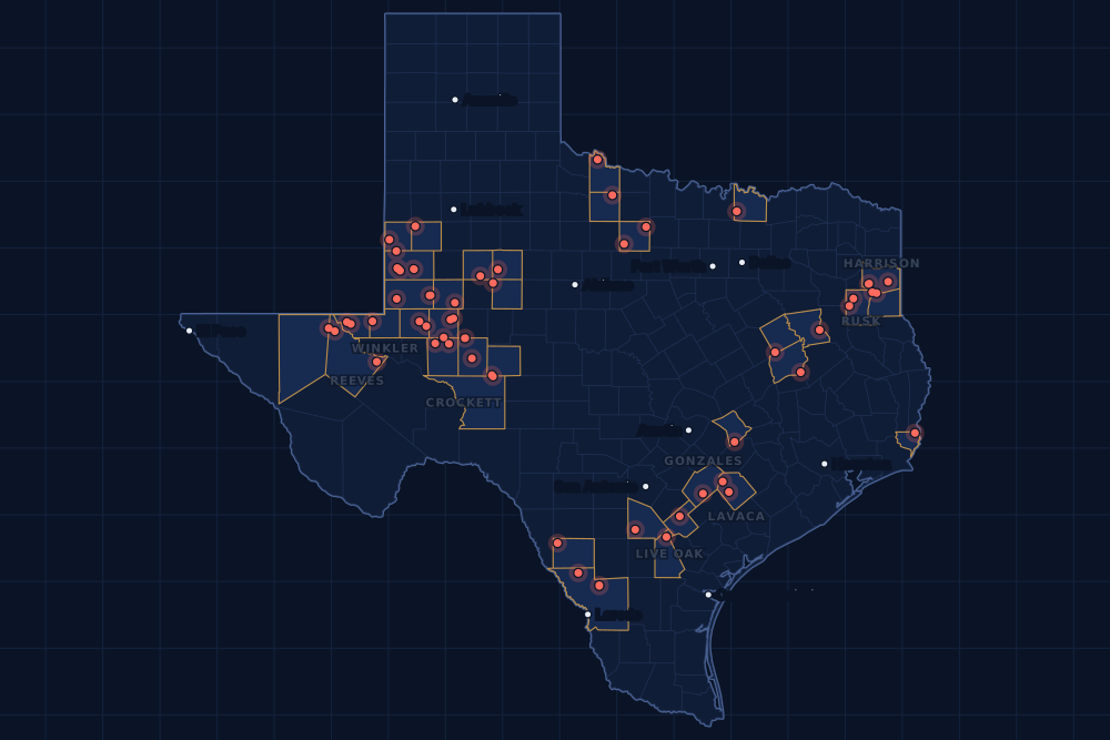
Counties and operators
Who drills, and where
Each county links to its Well Watch page, with its own map and every permit of the last two years. Each operator links to its page.
By county
- 1Andrews County20
- 2Reagan County11
- 3Gaines County8
- 4Midland County7
- 5Webb County7
- 6Ector County5
- 7Reeves County5
- 8Crockett County4
- 9Rusk County4
- 10Winkler County4
- 11Gonzales County3
- 12Harrison County3
- 13Lavaca County3
- 14Live Oak County3
- 15Upton County3
And 22 more counties with fewer, in the list below.
By operator
- 1Cog Operating LLC19
- 2Pioneer Natural Res. USA, Inc.11
- 3De Central Operating, LLC7
- 4Sem Operating Company LLC5
- 5Arrington OIL&GAS Operating LLC4
- 6Bce-Mach III LLC4
- 7Continental Resources, Inc.4
- 8Mewbourne Oil Company4
- 9Warwick Poseidon, GP4
- 10Burlington Resources O & G Co LP3
- 11Javelin Energy Partners Mgmt LLC3
- 12McClure Oil Company, Inc.3
- 13Sabine Energy Inc.3
- 14Basin Oil & Gas Operating, LLC2
- 15Bayswater Operating Company LLC2
And 30 more operators with fewer.
Register · July 13–19, 2026
Every permit, newest first
As the state files them: the lease and well, the operator, the kind of permit and the depth. “On the map” opens the county's live map at the well's spot.
Friday, July 1715 permits
- Baylor CountyWaggoner Dntt, well 265BWaggoner Operating, L.L.C. · new drill · vertical · 6,000 ftPermit 0917172 · API 42-023-31875On the map
- Borden CountyPeng Unit 14-02, well 6AHSurge Operating, LLC · new drill · horizontal · 9,000 ftPermit 0917160 · API 42-033-32850On the map
- Culberson CountyAlice Fee 34, well 8HCapitan Energy, Incorporated · new drill · horizontal · 9,850 ftPermit 0917233 · API 42-109-34619On the map
- Culberson CountyAlice Fee 34, well 7HCapitan Energy, Incorporated · new drill · horizontal · 9,550 ftPermit 0917232 · API 42-109-34620On the map
- Ector CountyJohnson, J. L. -Ab-, well 91WBasin Oil & Gas Operating, LLC · reclass · vertical · 4,300 ftPermit 0917023 · API 42-135-32972On the map
- Gaines CountyBrushfoot, well 8McClure Oil Company, Inc. · new drill · vertical · 6,000 ftPermit 0917200 · API 42-165-39038On the map
- Gaines CountyBrushfoot, well 5McClure Oil Company, Inc. · new drill · vertical · 6,000 ftPermit 0917199 · API 42-165-39037On the map
- Harrison CountyBryant Rains Bmp, well 1HComstock Oil & Gas, LLC · new drill · horizontal · 30,000 ftPermit 0916867 · API 42-203-35823On the map
- Lavaca CountyKorriban C, well 201HFW Eagle Ford I, LLC · new drill · horizontal · 14,500 ftPermit 0917100 · API 42-285-34378On the map
- Lavaca CountyKorriban A, well 1HFW Eagle Ford I, LLC · new drill · horizontal · 14,500 ftPermit 0917091 · API 42-285-34377On the map
- Live Oak CountyF. Malek Unit U, well 3Burlington Resources O & G Co LP · new drill · horizontal · 17,500 ftPermit 0917063 · API 42-297-36586On the map
- Midland CountyShauna E42M, well 113HPioneer Natural Res. USA, Inc. · new drill · horizontal · 10,931 ftPermit 0917171 · API 42-329-48510On the map
- Scurry CountyLion Diamond 'M' Unit, well F 9BKinder Morgan Production Co LLC · new drill · vertical · 7,800 ftPermit 0917184 · API 42-415-35805On the map
- Wilbarger CountyCondon, well 7Burk Royalty Co., Ltd. · field transfer · vertical · 8,900 ftPermit 0917212 · API 42-487-33168On the map
- Young CountyMcclurg, M. L., well 18Mammoth Operating LLC · new drill · vertical · 600 ftPermit 0917186 · API 42-503-42587On the map
Thursday, July 1639 permits
- Anderson CountyGibson, well 1Maximus Operating, Ltd. · new drill · vertical · 6,000 ftPermit 0917214 · API 42-001-32876On the map
- Andrews CountyMabee Dda A54, well 1011AHCog Operating LLC · new drill · horizontal · 12,000 ftPermit 0917197 · API 42-003-49402On the map
- Andrews CountyMabee Dda A52, well 1010BHCog Operating LLC · new drill · horizontal · 12,000 ftPermit 0917196 · API 42-003-49401On the map
- Andrews CountyMabee Dda A51, well 1010LHCog Operating LLC · new drill · horizontal · 12,000 ftPermit 0917195 · API 42-003-49400On the map
- Andrews CountyMabee Dda A50, well 1009MHCog Operating LLC · new drill · horizontal · 12,000 ftPermit 0917193 · API 42-003-49399On the map
- Andrews CountyMabee Dda A43, well 1006BHCog Operating LLC · new drill · horizontal · 12,000 ftPermit 0917182 · API 42-003-49398On the map
- Andrews CountyMabee Dda A42, well 1005AHCog Operating LLC · new drill · horizontal · 12,000 ftPermit 0917181 · API 42-003-49397On the map
- Andrews CountyMabee Dda A40, well 1004LHCog Operating LLC · new drill · horizontal · 12,000 ftPermit 0917180 · API 42-003-49396On the map
- Andrews CountyMabee Dda A39, well 1003BHCog Operating LLC · new drill · horizontal · 12,000 ftPermit 0917139 · API 42-003-49395On the map
- Andrews CountyMabee Dda A38, well 1003MHCog Operating LLC · new drill · horizontal · 12,000 ftPermit 0917136 · API 42-003-49388On the map
- Andrews CountyMabee Dda A37, well 1002LHCog Operating LLC · new drill · horizontal · 12,000 ftPermit 0917135 · API 42-003-49387On the map
- Andrews CountyMabee Dda A36, well 1001AHCog Operating LLC · new drill · horizontal · 12,000 ftPermit 0917133 · API 42-003-49386On the map
- Andrews CountyMabee Dda A35, well 1001JHCog Operating LLC · new drill · horizontal · 12,000 ftPermit 0917132 · API 42-003-49385On the map
- Ector CountyOptimus Prime East, well H110LSArrington OIL&GAS Operating LLC · new drill · horizontal · 9,200 ftPermit 0917189 · API 42-135-44281On the map
- Ector CountyOptimus Prime East, well H110WBArrington OIL&GAS Operating LLC · new drill · horizontal · 10,000 ftPermit 0917188 · API 42-135-44280On the map
- Ector CountyOptimus Prime East, well H110UHArrington OIL&GAS Operating LLC · new drill · horizontal · 10,500 ftPermit 0917187 · API 42-135-44279On the map
- Ector CountyOptimus Prime East, well H110NBArrington OIL&GAS Operating LLC · new drill · horizontal · 12,200 ftPermit 0917115 · API 42-135-44277On the map
- Freestone CountyReed 'E' Gas Unit, well 6Hilcorp Energy Company · recompletion · vertical · 14,010 ftPermit 0917173 · API 42-161-32639On the map
- Gaines CountyMoc Waters 22, well 6McClure Oil Company, Inc. · new drill · vertical · 6,000 ftPermit 0917202 · API 42-165-39039On the map
- Gonzales CountyBarnhart (Ef), well 206HMarathon Oil Ef LLC · new drill · horizontal · 17,500 ftPermit 0917218 · API 42-177-34847On the map
- Gonzales CountyBarnhart (Ef), well 205HMarathon Oil Ef LLC · new drill · horizontal · 17,500 ftPermit 0917217 · API 42-177-34846On the map
- Gonzales CountyBarnhart (Ef), well 207HEnsign Natural Resources II LLC · new drill · horizontal · 17,500 ftPermit 0917219 · API 42-177-34848On the map
- Harrison CountyHunt Hl A, well 2HPwep Operating, LLC · new drill · horizontal · 11,850 ftPermit 0916978 · API 42-203-35827On the map
- Harrison CountyCannon Cf, well 1HPwep Operating, LLC · new drill · horizontal · 11,900 ftPermit 0916956 · API 42-203-35825On the map
- Lee CountyNelda, well 1HIronbloom Operating, LLC · recompletion · horizontal · 9,063 ftPermit 0917170 · API 42-287-32749On the map
- Leon CountyTrinity Bluff, well 1Maximus Operating, Ltd. · new drill · vertical · 8,999 ftPermit 0917040 · API 42-289-32231On the map
- Live Oak CountyF. Malek Unit M, well 3Burlington Resources O & G Co LP · new drill · horizontal · 17,500 ftPermit 0917056 · API 42-297-36585On the map
- Live Oak CountyF. Malek Unit M, well 2Burlington Resources O & G Co LP · new drill · horizontal · 17,500 ftPermit 0917054 · API 42-297-36584On the map
- Martin CountyOndigo, well 1Deep Blue Operating I LLC · new drill · vertical · 9,000 ftPermit 0917206 · API 42-317-47371On the map
- Midland CountyShauna E42K, well 111HPioneer Natural Res. USA, Inc. · new drill · horizontal · 10,931 ftPermit 0917168 · API 42-329-48501On the map
- Midland CountyTurner-Buchanan 42B, well 2HPioneer Natural Res. USA, Inc. · new drill · horizontal · 10,344 ftPermit 0917074 · API 42-329-48489On the map
- Midland CountyTurner EC42B, well 102HPioneer Natural Res. USA, Inc. · new drill · horizontal · 10,326 ftPermit 0917065 · API 42-329-48484On the map
- Mitchell CountyMemphis 9-3-60, well H 3WBayswater Operating Company LLC · new drill · horizontal · 7,100 ftPermit 0917122 · API 42-335-36127On the map
- Mitchell CountyLuxor 9-3-60, well H 1WBayswater Operating Company LLC · new drill · horizontal · 7,100 ftPermit 0917121 · API 42-335-36126On the map
- Orange CountyPowell Group, well 1Bruington Operating II, LLC · new drill · vertical · 8,500 ftPermit 0917101 · API 42-361-30996On the map
- Reeves CountyState Barlow 57-T2-47X2 Ce, well W305HBPX Operating Company · new drill · horizontal · 12,182 ftPermit 0916558 · API 42-389-42185On the map
- Terry CountySuntura (Lower Clear Fork) Unit, well 520Basin Oil & Gas Operating, LLC · new drill · vertical · 8,700 ftPermit 0916980 · API 42-445-32510On the map
- Webb CountyStanley Ranch, well 104HBJavelin Energy Partners Mgmt LLC · new drill · horizontal · 12,000 ftPermit 0917058 · API 42-479-45675On the map
- Webb CountyStanley Ranch, well 104HAJavelin Energy Partners Mgmt LLC · new drill · horizontal · 12,000 ftPermit 0917057 · API 42-479-45674On the map
Wednesday, July 1510 permits
- Gaines CountyDenver Unit, well 6405Occidental Permian Ltd. · recompletion · vertical · 5,097 ftPermit 0917114 · API 42-165-01387On the map
- Grayson CountyMaggie Hunt, well 3BLS Production Co., Inc. · re-entry · vertical · 3,311 ftPermit 0917105 · API 42-181-30619On the map
- Loving CountyDbm 54-2-9, well 1DWes Water Holdings LLC · recompletion · vertical · 8,200 ftPermit 0917146 · API 42-301-35569On the map
- Rusk CountyColeman B Ou, well 2HSabine Energy Inc. · new drill · horizontal · 8,600 ftPermit 0917051 · API 42-401-35512On the map
- Rusk CountyColeman A Cv (Aw), well 1HSabine Energy Inc. · new drill · horizontal · 12,000 ftPermit 0917041 · API 42-401-35510On the map
- Winkler CountyBirdie 2803I, well 05HContinental Resources, Inc. · new drill · horizontal · 12,400 ftPermit 0917014 · API 42-495-35218On the map
- Winkler CountyBirdie 2803H, well 04HContinental Resources, Inc. · new drill · horizontal · 12,800 ftPermit 0917013 · API 42-495-35217On the map
- Winkler CountyBirdie 2803F, well 02HContinental Resources, Inc. · new drill · horizontal · 12,400 ftPermit 0917012 · API 42-495-35216On the map
- Winkler CountyBirdie 2803E, well 01HContinental Resources, Inc. · new drill · horizontal · 12,800 ftPermit 0917011 · API 42-495-35215On the map
- Young CountyS. R. Dozier, well 1Rogers Drilling Co., Inc. · new drill · vertical · 4,600 ftPermit 0917019 · API 42-503-42586On the map
Tuesday, July 1425 permits
- Andrews CountyState of Texas -V-, well 3Olsen Energy Inc. · recompletion · vertical · 10,120 ftPermit 0917086 · API 42-003-07181On the map
- Grayson CountyPerry Walker, well 1BLS Production Co., Inc. · re-entry · vertical · 3,978 ftPermit 0917103 · API 42-181-30209On the map
- Irion CountyUniversity 40, well 1102WASem Operating Company LLC · new drill · horizontal · 10,000 ftPermit 0917106 · API 42-235-36784On the map
- Karnes CountyMayer A, well 6HBPX Operating Company · new drill · horizontal · 14,000 ftPermit 0909478 · API 42-255-38298On the map
- Lavaca CountyWaska, well 1Royal Production Company, Inc. · new drill · vertical · 10,400 ftPermit 0917104 · API 42-285-34376On the map
- Loving CountyDbm 55-1-47, well 1DWes Water Holdings LLC · new drill · vertical · 7,200 ftPermit 0917039 · API 42-301-37923On the map
- Midland CountyTurner W43, well 101HPioneer Natural Res. USA, Inc. · new drill · horizontal · 10,326 ftPermit 0917060 · API 42-329-48482On the map
- Panola CountyTerlingua A Hv B, well 2HHR. Lacy Services, Ltd. · new drill · horizontal · 12,000 ftPermit 0916258 · API 42-365-39044On the map
- Reagan CountyUl Stl 15 East O 1216-28, well 4315HDe Central Operating, LLC · new drill · horizontal · 10,605 ftPermit 0917095 · API 42-383-42429On the map
- Reagan CountyUl Stl 15 East M 1216-28, well 4413HDe Central Operating, LLC · new drill · horizontal · 10,605 ftPermit 0917090 · API 42-383-42427On the map
- Reagan CountyUl Stl 15 East M 1216-28, well 4213HDe Central Operating, LLC · new drill · horizontal · 10,605 ftPermit 0917093 · API 42-383-42428On the map
- Reagan CountyUl Stl 15 East L 1216-28, well 4312HDe Central Operating, LLC · new drill · horizontal · 10,605 ftPermit 0917089 · API 42-383-42426On the map
- Reagan CountyUl Stl 15 East J 1216-28, well 4410HDe Central Operating, LLC · new drill · horizontal · 10,605 ftPermit 0917087 · API 42-383-42424On the map
- Reagan CountyUl Stl 15 East J 1216-28, well 4210HDe Central Operating, LLC · new drill · horizontal · 10,605 ftPermit 0917088 · API 42-383-42425On the map
- Reagan CountyUl Stl 15 East H 1216-28, well 4308HDe Central Operating, LLC · new drill · horizontal · 10,605 ftPermit 0917085 · API 42-383-42423On the map
- Reeves CountyDik Dik 17-18 D, well F101MPMewbourne Oil Company · new drill · horizontal · 14,847 ftPermit 0917128 · API 42-389-42220On the map
- Reeves CountyDik Dik 17-18 C, well F101LIMewbourne Oil Company · new drill · horizontal · 14,827 ftPermit 0917079 · API 42-389-42219On the map
- Reeves CountyDik Dik 17-18 B, well F101EHMewbourne Oil Company · new drill · horizontal · 15,673 ftPermit 0917078 · API 42-389-42218On the map
- Reeves CountyDik Dik 17-18 A, well F101DAMewbourne Oil Company · new drill · horizontal · 14,673 ftPermit 0917075 · API 42-389-42217On the map
- Upton CountyConnell 38 D, well U 5HMApache Corporation · new drill · horizontal · 12,000 ftPermit 0917003 · API 42-461-43729On the map
- Upton CountyRwt Katy 9-28 Unit, well 1515USChevron U. S. A. Inc. · new drill · horizontal · 12,000 ftPermit 0916333 · API 42-461-43685On the map
- Upton CountyRwt Katy 9-28 Unit, well 1517WBChevron U. S. A. Inc. · new drill · horizontal · 12,000 ftPermit 0916184 · API 42-461-43673On the map
- Webb CountyAi San Roman, well 208HWarwick Poseidon, GP · new drill · horizontal · 12,545 ftPermit 0917083 · API 42-479-45681On the map
- Webb CountyAi San Roman, well 206HWarwick Poseidon, GP · new drill · horizontal · 12,655 ftPermit 0917082 · API 42-479-45680On the map
- Yoakum CountyDesperado W 538, well 35HRiley Permian Operating Co, LLC · new drill · horizontal · 6,000 ftPermit 0917029 · API 42-501-37711On the map
Monday, July 1328 permits
- Andrews CountyMabee Dda A34, well 1112MHCog Operating LLC · new drill · horizontal · 12,000 ftPermit 0917022 · API 42-003-49384On the map
- Andrews CountyMabee Dda A33, well 1112BHCog Operating LLC · new drill · horizontal · 12,000 ftPermit 0917021 · API 42-003-49383On the map
- Andrews CountyMabee Dda A32, well 1112LHCog Operating LLC · new drill · horizontal · 12,000 ftPermit 0917009 · API 42-003-49382On the map
- Andrews CountyMabee Dda A31, well 1111JHCog Operating LLC · new drill · horizontal · 12,000 ftPermit 0917008 · API 42-003-49381On the map
- Andrews CountyMabee Dda A30, well 1110LHCog Operating LLC · new drill · horizontal · 12,000 ftPermit 0917007 · API 42-003-49380On the map
- Andrews CountyMabee Dda A29, well 1109MHCog Operating LLC · new drill · horizontal · 12,000 ftPermit 0917006 · API 42-003-49379On the map
- Andrews CountyMabee Dda A63, well 208AHCog Operating LLC · new drill · horizontal · 12,000 ftPermit 0916910 · API 42-003-49374On the map
- Atascosa CountyDally Unit, well 1HAlvarado 2014 LLC · new drill · horizontal · 8,000 ftPermit 0916991 · API 42-013-36287On the map
- Crockett CountyUniversity 40, well 1511WCSem Operating Company LLC · new drill · horizontal · 10,000 ftPermit 0917033 · API 42-105-42577On the map
- Crockett CountyUniversity 40, well 1509WCSem Operating Company LLC · new drill · horizontal · 10,000 ftPermit 0917032 · API 42-105-42576On the map
- Crockett CountyUniversity 40, well 1507WCSem Operating Company LLC · new drill · horizontal · 10,000 ftPermit 0917031 · API 42-105-42575On the map
- Crockett CountyUniversity 40, well 1503WCSem Operating Company LLC · new drill · horizontal · 10,000 ftPermit 0917028 · API 42-105-42574On the map
- Dimmit CountyComanche, well 6063HEl Toro Resources LLC · new drill · horizontal · 4,900 ftPermit 0917036 · API 42-127-39213On the map
- Gaines CountyNorth Robertson Unit, well 6370HBce-Mach III LLC · new drill · horizontal · 7,600 ftPermit 0916793 · API 42-165-39036On the map
- Gaines CountyNorth Riley Unit, well 2270HBce-Mach III LLC · new drill · horizontal · 5,200 ftPermit 0916791 · API 42-165-39033On the map
- Gaines CountyNorth Riley Unit, well 2290HBce-Mach III LLC · new drill · horizontal · 5,500 ftPermit 0916789 · API 42-165-39032On the map
- Gaines CountyNorth Riley Unit, well 2310HBce-Mach III LLC · new drill · horizontal · 9,000 ftPermit 0916786 · API 42-165-39031On the map
- Midland CountyTurner W43, well 3HPioneer Natural Res. USA, Inc. · new drill · horizontal · 10,344 ftPermit 0917061 · API 42-329-48483On the map
- Midland CountyTurner W39I, well 9HPioneer Natural Res. USA, Inc. · new drill · horizontal · 10,346 ftPermit 0916263 · API 42-329-48454On the map
- Reagan CountySpraberry Driver Unit, well 2727HPioneer Natural Res. USA, Inc. · new drill · horizontal · 8,122 ftPermit 0917050 · API 42-383-42422On the map
- Reagan CountySpraberry Driver Unit, well 2716HPioneer Natural Res. USA, Inc. · new drill · horizontal · 8,122 ftPermit 0917049 · API 42-383-42421On the map
- Reagan CountySpraberry Driver Unit, well 2708HPioneer Natural Res. USA, Inc. · new drill · horizontal · 8,122 ftPermit 0917048 · API 42-383-42420On the map
- Reagan CountySpraberry Driver Unit, well 2705HPioneer Natural Res. USA, Inc. · new drill · horizontal · 8,122 ftPermit 0917047 · API 42-383-42419On the map
- Rusk CountyHenderson 'E', well 8Buffco Production Inc. · recompletion · vertical · 10,850 ftPermit 0917053 · API 42-401-32970On the map
- Rusk CountyHelvenston C Cv (Aw), well 3HSabine Energy Inc. · new drill · horizontal · 12,000 ftPermit 0917005 · API 42-401-35508On the map
- Webb CountyAi San Roman, well 313HWarwick Poseidon, GP · new drill · horizontal · 12,355 ftPermit 0917073 · API 42-479-45678On the map
- Webb CountyAi San Roman, well 116HWarwick Poseidon, GP · new drill · horizontal · 12,155 ftPermit 0917071 · API 42-479-45677On the map
- Webb CountyStanley Ranch, well 104HCJavelin Energy Partners Mgmt LLC · new drill · horizontal · 12,000 ftPermit 0917062 · API 42-479-45676On the map
Cancelled permits are left out. To look a permit up at the source, use the Railroad Commission's drilling permit query with its permit number.
Archive
Earlier weeks
Each finished week, Monday to Sunday, has its own page that does not change. The feed gets one entry per week.
- Nov 9–15, 2026103
- Nov 2–8, 2026164
- Oct 26 – Nov 1, 2026242
- Oct 19–25, 2026215
- Oct 12–18, 2026147
- Oct 5–11, 2026152
- Sep 28 – Oct 4, 2026156
- Sep 21–27, 2026194
- Sep 14–20, 2026167
- Sep 7–13, 2026133
- Aug 31 – Sep 6, 2026182
- Aug 24–30, 2026118
Every week since January 1, 2024 (150 weeks)
2026
- Aug 17–23167
- Aug 10–16198
- Aug 3–9186
- Jul 27 – Aug 2143
- Jul 20–26170
- Jul 13–19117
- Jul 6–12194
- Jun 29 – Jul 5114
- Jun 22–28175
- Jun 15–21186
- Jun 8–14187
- Jun 1–7154
- May 25–31158
- May 18–24197
- May 11–17182
- May 4–10190
- Apr 27 – May 3156
- Apr 20–26210
- Apr 13–19133
- Apr 6–12206
- Mar 30 – Apr 5129
- Mar 23–29159
- Mar 16–22167
- Mar 9–15166
- Mar 2–8140
- Feb 23 – Mar 1181
- Feb 16–22141
- Feb 9–15133
- Feb 2–8124
- Jan 26 – Feb 1126
- Jan 19–25189
- Jan 12–18280
- Jan 5–11129
2025
- Dec 29 – Jan 4, 202656
- Dec 22–2846
- Dec 15–21154
- Dec 8–14119
- Dec 1–7128
- Nov 24–3061
- Nov 17–23140
- Nov 10–1698
- Nov 3–9107
- Oct 27 – Nov 2137
- Oct 20–26145
- Oct 13–19173
- Oct 6–12206
- Sep 29 – Oct 5124
- Sep 22–28141
- Sep 15–21165
- Sep 8–14127
- Sep 1–7105
- Aug 25–31145
- Aug 18–24115
- Aug 11–17140
- Aug 4–10131
- Jul 28 – Aug 3134
- Jul 21–27151
- Jul 14–20151
- Jul 7–13148
- Jun 30 – Jul 6148
- Jun 23–29167
- Jun 16–22118
- Jun 9–15115
- Jun 2–8147
- May 26 – Jun 190
- May 19–25148
- May 12–18120
- May 5–11114
- Apr 28 – May 4135
- Apr 21–27182
- Apr 14–20115
- Apr 7–13197
- Mar 31 – Apr 6194
- Mar 24–30170
- Mar 17–23189
- Mar 10–16177
- Mar 3–9141
- Feb 24 – Mar 2172
- Feb 17–23145
- Feb 10–16170
- Feb 3–9167
- Jan 27 – Feb 2149
- Jan 20–26158
- Jan 13–19176
- Jan 6–12140
2024
- Dec 30 – Jan 5, 202597
- Dec 23–295
- Dec 16–22168
- Dec 9–15202
- Dec 2–8182
- Nov 25 – Dec 189
- Nov 18–24189
- Nov 11–17145
- Nov 4–10152
- Oct 28 – Nov 3134
- Oct 21–27163
- Oct 14–20147
- Oct 7–13114
- Sep 30 – Oct 6138
- Sep 23–29133
- Sep 16–22175
- Sep 9–15144
- Sep 2–8138
- Aug 26 – Sep 1177
- Aug 19–25207
- Aug 12–18186
- Aug 5–11145
- Jul 29 – Aug 4191
- Jul 22–28174
- Jul 15–21164
- Jul 8–14205
- Jul 1–7106
- Jun 24–30183
- Jun 17–23192
- Jun 10–16161
- Jun 3–9176
- May 27 – Jun 2135
- May 20–26223
- May 13–19169
- May 6–12155
- Apr 29 – May 5191
- Apr 22–28224
- Apr 15–21200
- Apr 8–14157
- Apr 1–7149
- Mar 25–31102
- Mar 18–24130
- Mar 11–17228
- Mar 4–10178
- Feb 26 – Mar 3187
- Feb 19–25164
- Feb 12–18190
- Feb 5–11137
- Jan 29 – Feb 4177
- Jan 22–28172
- Jan 15–21107
- Jan 8–14251
- Jan 1–7148
FAQ
Questions people ask
What is a drilling permit?
Permission from the Railroad Commission of Texas to drill a well, or to re-enter or deepen an old one, at a stated spot and to a stated depth. An operator files for it before the rig comes; it lasts two years. Many permitted wells are drilled within months, some never are.
Is this week complete?
Yes. The state has issued permits on later days, so this week's list is closed. A permit the state cancels later drops off the list.
Some permits are not on the map. Why?
The map draws a permit at the well's surface location as the state files it. A new permit's location can take a few days to reach the state's files; until then it is listed here but not drawn.
Does a new permit near my land mean I will be paid?
No. A permit says where a well may be drilled, not whose minerals it will produce or who is paid. That depends on your lease, the unit the well is pooled in and the division order. If a well is drilled on or next to your tract, watch for a division order from the operator.
Can I get these by email or in a feed?
Yes. The feed on this page has one entry for each finished week, for any feed reader. For one county, an abstract or a lease, Texas Well Watch sends one email a week when the state files something new there; it is free with an account.
Sources
- Railroad Commission of Texas, drilling permit master and trailer, daily file (with latitudes and longitudes)www.rrc.texas.gov/resource-center/research/data-sets-available-for-download/ · loaded every night; newest permit on file November 20, 2026
- Railroad Commission of Texas, drilling permit query (one permit at the source)webapps.rrc.texas.gov/DP/initializePublicQueryAction.do · linked, not read
- US Census Bureau, cartographic boundary files (county lines), through the us-atlas package 3.0.1www.census.gov/geographies/mapping-files/time-series/geo/cartographic-boundary.html · built into the site with its well maps
- GeoNames, towns and their points (CC BY 4.0)www.geonames.org/ · built into the site with its town pages