
Railroad Commission of Texas · week of June 29, 2026
New Texas drilling permits, Jun 29 – Jul 5, 2026
- 114permits issued
- 86horizontal
- 40counties
- 44operators
That week
Where the state permitted wells
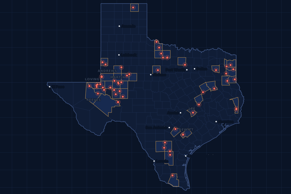
Counties and operators
Who drills, and where
Each county links to its Well Watch page, with its own map and every permit of the last two years. Each operator links to its page.
By county
- 1Upton County14
- 2De Witt County7
- 3Loving County7
- 4McMullen County7
- 5Reagan County7
- 6Reeves County7
- 7Winkler County7
- 8Ector County5
- 9Andrews County3
- 10Archer County3
- 11Glasscock County3
- 12Lee County3
- 13Martin County3
- 14Wilbarger County3
- 15Yoakum County3
And 25 more counties with fewer, in the list below.
By operator
- 1Black Swan Opco, LLC10
- 2Summit Petroleum LLC8
- 3Marathon Oil Ef LLC7
- 4Anadarko E&P Onshore LLC6
- 5EOG Resources, Inc.6
- 6WPX Energy Permian, LLC6
- 7Burk Royalty Co., Ltd.5
- 8Chevron U. S. A. Inc.5
- 9Firebird Energy II LLC5
- 10Bayswater Operating Company LLC4
- 11Continental Resources, Inc.4
- 12Waterbridge Stateline LLC4
- 13Diamondback E&P LLC3
- 14Pioneer Natural Res. USA, Inc.3
- 15Sage Natural Resources LLC3
And 29 more operators with fewer.
Register · June 29 – July 5, 2026
Every permit, newest first
As the state files them: the lease and well, the operator, the kind of permit and the depth. “On the map” opens the county's live map at the well's spot.
Thursday, July 241 permits
- Glasscock CountyPeffercorn, well 4HBlack Swan Opco, LLC · new drill · horizontal · 10,500 ftPermit 0916849 · API 42-173-39589On the map
- Glasscock CountySquints, well 1HBlack Swan Opco, LLC · new drill · horizontal · 10,500 ftPermit 0916836 · API 42-173-39586On the map
- Harrison CountyFlying Ll Trust, well 1Buffco Production Inc. · recompletion · vertical · 12,316 ftPermit 0916805 · API 42-203-34617On the map
- Loving CountyCross Mountain 4045-28, well 316HWPX Energy Permian, LLC · new drill · horizontal · 14,000 ftPermit 0916643 · API 42-301-37915On the map
- McMullen CountyLoveland D, well 4HEOG Resources, Inc. · new drill · horizontal · 10,600 ftPermit 0916788 · API 42-311-37704On the map
- McMullen CountyLoveland C, well 3HEOG Resources, Inc. · new drill · horizontal · 10,600 ftPermit 0916787 · API 42-311-37703On the map
- McMullen CountyLoveland B, well 2HEOG Resources, Inc. · new drill · horizontal · 10,600 ftPermit 0916785 · API 42-311-37702On the map
- McMullen CountyLoveland A, well 1HEOG Resources, Inc. · new drill · horizontal · 10,600 ftPermit 0916780 · API 42-311-37701On the map
- Midland CountyTurner E41H, well 8HPioneer Natural Res. USA, Inc. · new drill · horizontal · 10,317 ftPermit 0916198 · API 42-329-48443On the map
- Pecos CountyYates Field Unit, well 47B14Kinder Morgan Production Co LLC · reclass · vertical · 1,999 ftPermit 0916808 · API 42-371-32317On the map
- Reeves CountySasquatch State 56-2-38 Unit, well 15HAnadarko E&P Onshore LLC · new drill · horizontal · 13,000 ftPermit 0916784 · API 42-389-42200On the map
- Reeves CountySasquatch State 56-2-38 Unit, well 14HAnadarko E&P Onshore LLC · new drill · horizontal · 13,000 ftPermit 0916783 · API 42-389-42199On the map
- Reeves CountySasquatch State 56-2-38 Unit, well 13HAnadarko E&P Onshore LLC · new drill · horizontal · 13,000 ftPermit 0916782 · API 42-389-42198On the map
- Reeves CountySasquatch State 56-2-38 Unit, well 12HAnadarko E&P Onshore LLC · new drill · horizontal · 13,000 ftPermit 0916781 · API 42-389-42197On the map
- Reeves CountySasquatch State 56-2-38 Unit, well 21HAnadarko E&P Onshore LLC · new drill · horizontal · 13,000 ftPermit 0916779 · API 42-389-42196On the map
- Shackelford CountySimpson, well 7Stasney Well Service, LLC · new drill · vertical · 990 ftPermit 0916796 · API 42-417-39841On the map
- Shackelford CountySimpson, well 6Stasney Well Service, LLC · new drill · vertical · 990 ftPermit 0916792 · API 42-417-39840On the map
- Upton CountyMary Lou 14, well 28JMSummit Petroleum LLC · new drill · horizontal · 7,700 ftPermit 0916694 · API 42-461-43708On the map
- Upton CountyMary Lou 13, well 26BUSummit Petroleum LLC · new drill · horizontal · 8,600 ftPermit 0916691 · API 42-461-43706On the map
- Upton CountyMary Lou 12, well 24MSSummit Petroleum LLC · new drill · horizontal · 7,100 ftPermit 0916690 · API 42-461-43707On the map
- Upton CountyMary Lou 7, well 14DNSummit Petroleum LLC · new drill · horizontal · 8,100 ftPermit 0916646 · API 42-461-43705On the map
- Upton CountyMary Lou 6, well 12JMSummit Petroleum LLC · new drill · horizontal · 7,700 ftPermit 0916641 · API 42-461-43704On the map
- Upton CountyMary Lou 5, well 10BLSummit Petroleum LLC · new drill · horizontal · 9,200 ftPermit 0916631 · API 42-461-43701On the map
- Upton CountyMary Lou 4, well 08MSSummit Petroleum LLC · new drill · horizontal · 7,100 ftPermit 0916579 · API 42-461-43700On the map
- Upton CountyMary Lou 1, well 02BUSummit Petroleum LLC · new drill · horizontal · 9,200 ftPermit 0916572 · API 42-461-43697On the map
- Upton CountyRwt Katy 9-28 Unit, well 1518WBChevron U. S. A. Inc. · new drill · horizontal · 12,000 ftPermit 0916186 · API 42-461-43659On the map
- Upton CountyRwt Katy 9-28 Unit, well 1516LSChevron U. S. A. Inc. · new drill · horizontal · 12,000 ftPermit 0916183 · API 42-461-43658On the map
- Upton CountyRwt Katy 9-28 Unit, well 1513USChevron U. S. A. Inc. · new drill · horizontal · 12,000 ftPermit 0916182 · API 42-461-43656On the map
- Upton CountyRwt Katy 9-28 Unit, well 1512LSChevron U. S. A. Inc. · new drill · horizontal · 12,000 ftPermit 0916181 · API 42-461-43655On the map
- Upton CountyRwt Katy 9-28 Unit, well 1511USChevron U. S. A. Inc. · new drill · horizontal · 12,000 ftPermit 0916147 · API 42-461-43657On the map
- Wilbarger CountyWaggoner Dn, well 19Burk Royalty Co., Ltd. · recompletion · vertical · 2,575 ftPermit 0916877 · API 42-487-32954On the map
- Wilson CountyMcbee-Mattke Unit, well 1HPaloma Operating, LLC · new drill · horizontal · 4,148 ftPermit 0916689 · API 42-493-33037On the map
- Winkler CountyBogey 0409J, well 10HContinental Resources, Inc. · new drill · horizontal · 12,400 ftPermit 0916874 · API 42-495-35211On the map
- Winkler CountyBogey 0409I, well 09HContinental Resources, Inc. · new drill · horizontal · 12,746 ftPermit 0916873 · API 42-495-35210On the map
- Winkler CountyBogey 0409H, well 08HContinental Resources, Inc. · new drill · horizontal · 12,000 ftPermit 0916872 · API 42-495-35209On the map
- Winkler CountyBogey 0409G, well 07HContinental Resources, Inc. · new drill · horizontal · 12,400 ftPermit 0916870 · API 42-495-35208On the map
- Winkler CountyState-Walton, well 1CBasin Oil & Gas Operating, LLC · recompletion · vertical · 10,000 ftPermit 0916762 · API 42-495-05173On the map
- Winkler CountySealy Smith Foundation -A-, well 330HBlackbeard Operating, LLC · new drill · horizontal · 7,999 ftPermit 0916636 · API 42-495-35200On the map
- Winkler CountySealy Smith Foundation -A-, well 329HBlackbeard Operating, LLC · new drill · horizontal · 7,999 ftPermit 0916635 · API 42-495-35199On the map
- Wise CountyVinson Fee B 5 (Aw), well 5HBKV North Texas, LLC · new drill · horizontal · 11,359 ftPermit 0916478 · API 42-497-38160On the map
- Yoakum CountyAurora, well 1HBurk Royalty Co., Ltd. · new drill · horizontal · 6,000 ftPermit 0916790 · API 42-501-37706On the map
Wednesday, July 127 permits
- Archer CountyBenson Estate -E-, well 14Wilcox Energy Company LLC · new drill · vertical · 1,500 ftPermit 0916733 · API 42-009-43438On the map
- Archer CountyMustang, well 6Eagle Oil & Gas Co. · new drill · vertical · 5,500 ftPermit 0916416 · API 42-009-43435On the map
- Cass CountyFuller, well 1HRose City Resources, LLC · new drill · horizontal · 13,000 ftPermit 0915860 · API 42-067-30981On the map
- De Witt CountySchorlemer Quad Sa A, well 1Marathon Oil Ef LLC · new drill · horizontal · 17,500 ftPermit 0916038 · API 42-123-35787On the map
- Ector CountyPocket Pair 2715 C, well 802HFirebird Energy II LLC · new drill · horizontal · 12,000 ftPermit 0916723 · API 42-135-44276On the map
- Ector CountyPocket Pair 2715 A, well 801HFirebird Energy II LLC · new drill · horizontal · 12,000 ftPermit 0916721 · API 42-135-44274On the map
- Ector CountyPocket Pair 2722 C, well 803HFirebird Energy II LLC · new drill · horizontal · 12,000 ftPermit 0916684 · API 42-135-44273On the map
- Ector CountyPocket Pair 2722 B, well 902HFirebird Energy II LLC · new drill · horizontal · 12,100 ftPermit 0916683 · API 42-135-44271On the map
- Ector CountyPocket Pair 2722 A, well 804HFirebird Energy II LLC · new drill · horizontal · 12,000 ftPermit 0916682 · API 42-135-44272On the map
- Freestone CountyH. L. & P. Gas Unit, well 17Hilcorp Energy Company · recompletion · vertical · 14,300 ftPermit 0916807 · API 42-161-33308On the map
- Glasscock CountyPeffercorn, well 3HBlack Swan Opco, LLC · new drill · horizontal · 10,500 ftPermit 0916838 · API 42-173-39588On the map
- Jasper CountyPredator, well 1Whitehead Resources, Ltd. · new drill · vertical · 4,000 ftPermit 0916795 · API 42-241-30939On the map
- Jasper CountyAries, well 1Whitehead Resources, Ltd. · new drill · vertical · 4,000 ftPermit 0916794 · API 42-241-30938On the map
- Lee CountyAlbert Luecke Ef North, well 1HSage Natural Resources LLC · new drill · horizontal · 9,000 ftPermit 0916816 · API 42-287-32824On the map
- Lee CountyAlbert Luecke Ef South, well 2HSage Natural Resources LLC · new drill · horizontal · 9,000 ftPermit 0916745 · API 42-287-32822On the map
- Morris CountyCosmopolitan, well 1HRose City Resources, LLC · new drill · horizontal · 13,000 ftPermit 0915887 · API 42-343-30141On the map
- Reagan CountyUl Acfd 4475 C, well 0806Black Swan Opco, LLC · new drill · horizontal · 7,300 ftPermit 0916815 · API 42-383-42405On the map
- Reagan CountyUl Acfd 4475 B, well 0807Black Swan Opco, LLC · new drill · horizontal · 9,500 ftPermit 0916812 · API 42-383-42402On the map
- Reagan CountyUl Acfd 4475 B, well 0803UBBlack Swan Opco, LLC · new drill · horizontal · 7,900 ftPermit 0916811 · API 42-383-42401On the map
- Reagan CountyUl Acfd 4475 A, well 0802LBBlack Swan Opco, LLC · new drill · horizontal · 8,200 ftPermit 0916810 · API 42-383-42400On the map
- Reagan CountyUl Acfd 4475 A, well 0801WABlack Swan Opco, LLC · new drill · horizontal · 7,500 ftPermit 0916809 · API 42-383-42399On the map
- Reagan CountyUl Acfd 4475 C, well 0805LBBlack Swan Opco, LLC · new drill · horizontal · 8,200 ftPermit 0916814 · API 42-383-42404On the map
- Reagan CountyUl Acfd 4475 C, well 0804WABlack Swan Opco, LLC · new drill · horizontal · 7,500 ftPermit 0916813 · API 42-383-42403On the map
- Reeves CountySasquatch State 56-2-38 Unit, well 11HRAnadarko E&P Onshore LLC · new drill · horizontal · 13,000 ftPermit 0916778 · API 42-389-42195On the map
- Ward CountyEdwards, Jno. Et Al B, well 5Pitts Energy Co. · recompletion · vertical · 5,700 ftPermit 0916749 · API 42-475-33943On the map
- Wilbarger CountyCaddis, well 1Burk Royalty Co., Ltd. · field transfer · vertical · 8,900 ftPermit 0916800 · API 42-487-33325On the map
- Yoakum CountyStromness, well 1HBurk Royalty Co., Ltd. · new drill · horizontal · 6,000 ftPermit 0916799 · API 42-501-37707On the map
Tuesday, June 3021 permits
- Anderson CountyFitzgerald, well I011Trueblood Resources, Inc. · new drill · vertical · 670 ftPermit 0916699 · API 42-001-32874On the map
- Archer CountyHill R. E., well 50Palmer Operating LLC · new drill · vertical · 1,900 ftPermit 0916434 · API 42-009-43434On the map
- De Witt CountyHope-Dwor-Saun B Sa A, well 1Marathon Oil Ef LLC · new drill · horizontal · 17,500 ftPermit 0916055 · API 42-123-35793On the map
- Howard CountyVertigo 6-7, well H 1WABayswater Operating Company LLC · new drill · horizontal · 8,500 ftPermit 0916706 · API 42-227-42904On the map
- Howard CountyVertigo 6-7, well H 2WABayswater Operating Company LLC · new drill · horizontal · 8,500 ftPermit 0916704 · API 42-227-42903On the map
- Loving CountyCross Mountain 4045-28, well 315HWPX Energy Permian, LLC · new drill · horizontal · 14,000 ftPermit 0916637 · API 42-301-37914On the map
- Loving CountyCross Mountain 4045-28, well 314HWPX Energy Permian, LLC · new drill · horizontal · 14,000 ftPermit 0916634 · API 42-301-37913On the map
- Loving CountyCross Mountain 4045-28 West, well 313HWPX Energy Permian, LLC · new drill · horizontal · 14,000 ftPermit 0916630 · API 42-301-37912On the map
- Loving CountyCross Mountain 4045-28 West, well 312HWPX Energy Permian, LLC · new drill · horizontal · 14,000 ftPermit 0916629 · API 42-301-37911On the map
- Loving CountyCross Mountain 4045-28 West, well 311HWPX Energy Permian, LLC · new drill · horizontal · 14,000 ftPermit 0916617 · API 42-301-37910On the map
- Marion CountyCommodores (Aw), well 1HRfe Operating, LLC · new drill · horizontal · 9,675 ftPermit 0916522 · API 42-315-31078On the map
- Martin CountyAutry 5-8 J, well 3BNDiamondback E&P LLC · new drill · horizontal · 13,000 ftPermit 0916397 · API 42-317-47339On the map
- Martin CountyAutry 5-8 I, well 2BNDiamondback E&P LLC · new drill · horizontal · 13,000 ftPermit 0916396 · API 42-317-47338On the map
- Martin CountyAutry 5-8 H, well 1BNDiamondback E&P LLC · new drill · horizontal · 13,000 ftPermit 0916387 · API 42-317-47335On the map
- Panola CountyWerner-Lagrone Unit, well 3HRTGNR Panola LLC · new drill · horizontal · 22,000 ftPermit 0916769 · API 42-365-39037On the map
- Pecos CountyYates Field Unit, well 49A73Kinder Morgan Production Co LLC · reclass · horizontal · 1,999 ftPermit 0916724 · API 42-371-32864On the map
- Robertson CountyLightsey D, well 1HAWildfire Energy Operating LLC · new drill · horizontal · 8,000 ftPermit 0916036 · API 42-395-32134On the map
- Rusk CountyPat Gratton, well 1HBuckhorn Operating LLC · new drill · horizontal · 10,500 ftPermit 0916613 · API 42-401-35505On the map
- Upton CountyPembrook Unit, well 1716HPioneer Natural Res. USA, Inc. · new drill · horizontal · 8,396 ftPermit 0916839 · API 42-461-43713On the map
- Wilbarger CountyCaddis, well 2Burk Royalty Co., Ltd. · field transfer · vertical · 8,900 ftPermit 0916802 · API 42-487-33387On the map
- Yoakum CountyWasson Odc Unit, well 811Occidental Permian Ltd. · recompletion · vertical · 5,477 ftPermit 0916707 · API 42-501-36624On the map
Monday, June 2925 permits
- Andrews CountySpdtx SWD, well 25Waterbridge Stateline LLC · new drill · vertical · 9,000 ftPermit 0916768 · API 42-003-49358On the map
- Andrews CountySpdtx SWD, well 23Waterbridge Stateline LLC · new drill · vertical · 9,000 ftPermit 0916767 · API 42-003-49357On the map
- Andrews CountySpdtx SWD, well 12Waterbridge Stateline LLC · new drill · vertical · 9,000 ftPermit 0916766 · API 42-003-49356On the map
- Baylor CountyWaggoner Erl, well 1002ERWaggoner Operating, L.L.C. · new drill · vertical · 4,000 ftPermit 0916763 · API 42-023-31874On the map
- Dawson CountyAncient Briton, well 1Estacado Resources, LLC · new drill · vertical · 10,500 ftPermit 0916772 · API 42-115-34135On the map
- De Witt CountyHope-Saunders B Sa E, well 1Marathon Oil Ef LLC · new drill · horizontal · 17,500 ftPermit 0916051 · API 42-123-35792On the map
- De Witt CountyHope-Saunders B Sa D, well 1Marathon Oil Ef LLC · new drill · horizontal · 17,500 ftPermit 0916049 · API 42-123-35791On the map
- De Witt CountyHope-Saunders B Sa C, well 1Marathon Oil Ef LLC · new drill · horizontal · 17,500 ftPermit 0916047 · API 42-123-35790On the map
- De Witt CountyHope-Saunders B Sa B, well 1Marathon Oil Ef LLC · new drill · horizontal · 17,500 ftPermit 0916045 · API 42-123-35789On the map
- De Witt CountyHope-Saunders B Sa A, well 1Marathon Oil Ef LLC · new drill · horizontal · 17,500 ftPermit 0916044 · API 42-123-35788On the map
- Duval CountyLopez Unit, well 1Cimarron Engineering, LLC · new drill · vertical · 3,600 ftPermit 0916615 · API 42-131-39702On the map
- Hidalgo CountyMcallen, A. A., well 109Merit Energy Company · recompletion · vertical · 14,400 ftPermit 0916390 · API 42-215-32844On the map
- La Salle CountySP5 A, well 501HCaturus Energy, LLC · new drill · horizontal · 17,500 ftPermit 0916058 · API 42-283-37908On the map
- Lee CountyAlbert Luecke Ef South, well 1HSage Natural Resources LLC · new drill · horizontal · 9,000 ftPermit 0916744 · API 42-287-32821On the map
- Loving CountyFpw SWD, well 10Waterbridge Stateline LLC · new drill · vertical · 9,000 ftPermit 0916765 · API 42-301-37921On the map
- McMullen CountyCampana De Fe, well 1Columbus Energy, LLC · new drill · vertical · 3,500 ftPermit 0916756 · API 42-311-37700On the map
- McMullen CountyOliveira J, well 9HEOG Resources, Inc. · new drill · horizontal · 10,600 ftPermit 0916739 · API 42-311-37699On the map
- McMullen CountyOliveira H, well 8HEOG Resources, Inc. · new drill · horizontal · 10,600 ftPermit 0916738 · API 42-311-37698On the map
- Midland CountyGolladay-Mcalister 51G, well 7HPioneer Natural Res. USA, Inc. · new drill · horizontal · 10,391 ftPermit 0915959 · API 42-329-45580On the map
- Mitchell CountyOasis 9-16-33-40, well H 1WBayswater Operating Company LLC · new drill · horizontal · 7,300 ftPermit 0915988 · API 42-335-36122On the map
- Mitchell CountyOasis 9-16-33-40, well H 2WBayswater Operating Company LLC · new drill · horizontal · 7,300 ftPermit 0915987 · API 42-335-36121On the map
- Ochiltree CountyThurman 23, well 1HKing Operating Corporation · new drill · horizontal · 9,000 ftPermit 0916686 · API 42-357-33781On the map
- Reeves CountyRattler 23, well 2SBBlue Arrow Operating, LLC · new drill · horizontal · 9,500 ftPermit 0916511 · API 42-389-42186On the map
- Wood CountyNeuhoff (Buda-Woodbine) Unit, well 18STMontare Operating, Ltd. · recompletion · vertical · 9,760 ftPermit 0916760 · API 42-499-31731On the map
- Wood CountyNeuhoff (Buda-Woodbine) Unit, well 10STMontare Operating, Ltd. · recompletion · vertical · 10,000 ftPermit 0916758 · API 42-499-31379On the map
Cancelled permits are left out. To look a permit up at the source, use the Railroad Commission's drilling permit query with its permit number.
Archive
Earlier weeks
Each finished week, Monday to Sunday, has its own page that does not change. The feed gets one entry per week.
- Nov 9–15, 2026103
- Nov 2–8, 2026164
- Oct 26 – Nov 1, 2026242
- Oct 19–25, 2026215
- Oct 12–18, 2026147
- Oct 5–11, 2026152
- Sep 28 – Oct 4, 2026156
- Sep 21–27, 2026194
- Sep 14–20, 2026167
- Sep 7–13, 2026133
- Aug 31 – Sep 6, 2026182
- Aug 24–30, 2026118
Every week since January 1, 2024 (150 weeks)
2026
- Aug 17–23167
- Aug 10–16198
- Aug 3–9186
- Jul 27 – Aug 2143
- Jul 20–26170
- Jul 13–19117
- Jul 6–12194
- Jun 29 – Jul 5114
- Jun 22–28175
- Jun 15–21186
- Jun 8–14187
- Jun 1–7154
- May 25–31158
- May 18–24197
- May 11–17182
- May 4–10190
- Apr 27 – May 3156
- Apr 20–26210
- Apr 13–19133
- Apr 6–12206
- Mar 30 – Apr 5129
- Mar 23–29159
- Mar 16–22167
- Mar 9–15166
- Mar 2–8140
- Feb 23 – Mar 1181
- Feb 16–22141
- Feb 9–15133
- Feb 2–8124
- Jan 26 – Feb 1126
- Jan 19–25189
- Jan 12–18280
- Jan 5–11129
2025
- Dec 29 – Jan 4, 202656
- Dec 22–2846
- Dec 15–21154
- Dec 8–14119
- Dec 1–7128
- Nov 24–3061
- Nov 17–23140
- Nov 10–1698
- Nov 3–9107
- Oct 27 – Nov 2137
- Oct 20–26145
- Oct 13–19173
- Oct 6–12206
- Sep 29 – Oct 5124
- Sep 22–28141
- Sep 15–21165
- Sep 8–14127
- Sep 1–7105
- Aug 25–31145
- Aug 18–24115
- Aug 11–17140
- Aug 4–10131
- Jul 28 – Aug 3134
- Jul 21–27151
- Jul 14–20151
- Jul 7–13148
- Jun 30 – Jul 6148
- Jun 23–29167
- Jun 16–22118
- Jun 9–15115
- Jun 2–8147
- May 26 – Jun 190
- May 19–25148
- May 12–18120
- May 5–11114
- Apr 28 – May 4135
- Apr 21–27182
- Apr 14–20115
- Apr 7–13197
- Mar 31 – Apr 6194
- Mar 24–30170
- Mar 17–23189
- Mar 10–16177
- Mar 3–9141
- Feb 24 – Mar 2172
- Feb 17–23145
- Feb 10–16170
- Feb 3–9167
- Jan 27 – Feb 2149
- Jan 20–26158
- Jan 13–19176
- Jan 6–12140
2024
- Dec 30 – Jan 5, 202597
- Dec 23–295
- Dec 16–22168
- Dec 9–15202
- Dec 2–8182
- Nov 25 – Dec 189
- Nov 18–24189
- Nov 11–17145
- Nov 4–10152
- Oct 28 – Nov 3134
- Oct 21–27163
- Oct 14–20147
- Oct 7–13114
- Sep 30 – Oct 6138
- Sep 23–29133
- Sep 16–22175
- Sep 9–15144
- Sep 2–8138
- Aug 26 – Sep 1177
- Aug 19–25207
- Aug 12–18186
- Aug 5–11145
- Jul 29 – Aug 4191
- Jul 22–28174
- Jul 15–21164
- Jul 8–14205
- Jul 1–7106
- Jun 24–30183
- Jun 17–23192
- Jun 10–16161
- Jun 3–9176
- May 27 – Jun 2135
- May 20–26223
- May 13–19169
- May 6–12155
- Apr 29 – May 5191
- Apr 22–28224
- Apr 15–21200
- Apr 8–14157
- Apr 1–7149
- Mar 25–31102
- Mar 18–24130
- Mar 11–17228
- Mar 4–10178
- Feb 26 – Mar 3187
- Feb 19–25164
- Feb 12–18190
- Feb 5–11137
- Jan 29 – Feb 4177
- Jan 22–28172
- Jan 15–21107
- Jan 8–14251
- Jan 1–7148
FAQ
Questions people ask
What is a drilling permit?
Permission from the Railroad Commission of Texas to drill a well, or to re-enter or deepen an old one, at a stated spot and to a stated depth. An operator files for it before the rig comes; it lasts two years. Many permitted wells are drilled within months, some never are.
Is this week complete?
Yes. The state has issued permits on later days, so this week's list is closed. A permit the state cancels later drops off the list.
Some permits are not on the map. Why?
The map draws a permit at the well's surface location as the state files it. A new permit's location can take a few days to reach the state's files; until then it is listed here but not drawn.
Does a new permit near my land mean I will be paid?
No. A permit says where a well may be drilled, not whose minerals it will produce or who is paid. That depends on your lease, the unit the well is pooled in and the division order. If a well is drilled on or next to your tract, watch for a division order from the operator.
Can I get these by email or in a feed?
Yes. The feed on this page has one entry for each finished week, for any feed reader. For one county, an abstract or a lease, Texas Well Watch sends one email a week when the state files something new there; it is free with an account.
Sources
- Railroad Commission of Texas, drilling permit master and trailer, daily file (with latitudes and longitudes)www.rrc.texas.gov/resource-center/research/data-sets-available-for-download/ · loaded every night; newest permit on file November 20, 2026
- Railroad Commission of Texas, drilling permit query (one permit at the source)webapps.rrc.texas.gov/DP/initializePublicQueryAction.do · linked, not read
- US Census Bureau, cartographic boundary files (county lines), through the us-atlas package 3.0.1www.census.gov/geographies/mapping-files/time-series/geo/cartographic-boundary.html · built into the site with its well maps
- GeoNames, towns and their points (CC BY 4.0)www.geonames.org/ · built into the site with its town pages