
Railroad Commission of Texas · week of July 28, 2025
New Texas drilling permits, Jul 28 – Aug 3, 2025
- 134permits issued
- 96horizontal
- 35counties
- 41operators
That week
Where the state permitted wells
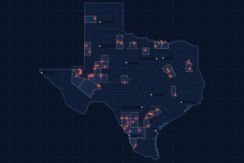
Counties and operators
Who drills, and where
Each county links to its Well Watch page, with its own map and every permit of the last two years. Each operator links to its page.
By county
- 1Martin County19
- 2Loving County16
- 3Crane County10
- 4Midland County9
- 5De Witt County8
- 6Pecos County6
- 7Reagan County6
- 8Webb County6
- 9Borden County4
- 10Concho County4
- 11Karnes County4
- 12Upton County4
- 13Zavala County4
- 14Baylor County3
- 15Live Oak County3
And 20 more counties with fewer, in the list below.
By operator
- 1Cog Operating LLC18
- 2EOG Resources, Inc.11
- 3Blackbeard Operating, LLC9
- 4Burlington Resources O & G Co LP9
- 5XTO Energy Inc.7
- 6Kinder Morgan Production Co LLC6
- 7Wes Water Holdings LLC6
- 8Ovintiv USA Inc.5
- 9Diamondback E&P LLC4
- 10Fasken Oil and Ranch, Ltd.4
- 11Harvest Petroleum Inc.4
- 12Javelin Energy Partners Mgmt LLC4
- 13Petroplex Energy Inc.4
- 14Devon Energy Production Co, L.P.3
- 15Gunn Oil Company3
And 26 more operators with fewer.
Register · July 28 – August 3, 2025
Every permit, newest first
As the state files them: the lease and well, the operator, the kind of permit and the depth. “On the map” opens the county's live map at the well's spot.
Friday, August 126 permits
- Baylor CountyWaggoner Dntw, well 2655DNWaggoner Operating, L.L.C. · new drill · vertical · 6,000 ftPermit 0909607 · API 42-023-31835On the map
- Cochran CountyIke Clanton C, well 3HManzano, LLC · new drill · horizontal · 5,500 ftPermit 0909542 · API 42-079-33437On the map
- Concho CountyConcho 204, well 4Harvest Petroleum Inc. · new drill · vertical · 5,000 ftPermit 0909638 · API 42-095-32475On the map
- Concho CountyConcho 203, well 3Harvest Petroleum Inc. · new drill · vertical · 5,000 ftPermit 0909637 · API 42-095-32474On the map
- Concho CountyConcho 202, well 2Harvest Petroleum Inc. · new drill · vertical · 5,000 ftPermit 0909636 · API 42-095-32473On the map
- Concho CountyConcho 201, well 1Harvest Petroleum Inc. · new drill · vertical · 5,000 ftPermit 0909635 · API 42-095-32472On the map
- Crane CountyWaddell Tr 1, well 5402HBlackbeard Operating, LLC · new drill · horizontal · 14,000 ftPermit 0909591 · API 42-103-37659On the map
- Crane CountyWaddell Tr 1, well 5596HBlackbeard Operating, LLC · new drill · horizontal · 14,000 ftPermit 0909586 · API 42-103-37658On the map
- Dimmit CountyDiamond H Ranch 101HB, well 101HBJavelin Energy Partners Mgmt LLC · new drill · horizontal · 9,000 ftPermit 0909332 · API 42-127-39074On the map
- Dimmit CountyDiamond H Ranch 101HA, well 101HAJavelin Energy Partners Mgmt LLC · new drill · horizontal · 9,000 ftPermit 0909331 · API 42-127-39073On the map
- Grimes CountyT.j. Tucker Unit No. 2, well 3Galloway Energy Co. · new drill · vertical · 12,800 ftPermit 0909557 · API 42-185-30902On the map
- Loving CountyFpw SWD, well 22Waterbridge Stateline LLC · new drill · vertical · 9,000 ftPermit 0909598 · API 42-301-37485On the map
- Loving CountyRigel 28-30, well 1DWes Water Holdings LLC · new drill · vertical · 9,000 ftPermit 0909584 · API 42-301-37494On the map
- Loving CountyVega 28-41, well 1DWes Water Holdings LLC · new drill · vertical · 9,000 ftPermit 0909582 · API 42-301-37493On the map
- Loving CountyScorpio 28-41, well 1DWes Water Holdings LLC · new drill · vertical · 9,000 ftPermit 0909579 · API 42-301-37492On the map
- Loving CountyDraco 28-19, well 1DWes Water Holdings LLC · new drill · vertical · 9,000 ftPermit 0909566 · API 42-301-37491On the map
- Loving CountyLibra 29-36, well 1DWes Water Holdings LLC · new drill · vertical · 9,000 ftPermit 0909565 · API 42-301-37490On the map
- Loving CountyLeo 28-18, well 1DWes Water Holdings LLC · new drill · vertical · 9,000 ftPermit 0909564 · API 42-301-37484On the map
- Midland CountyCasselman D West Unit, well 4Fasken Oil and Ranch, Ltd. · new drill · horizontal · 12,200 ftPermit 0909618 · API 42-329-47888On the map
- Midland CountyCasselman D Unit, well 3Fasken Oil and Ranch, Ltd. · new drill · horizontal · 12,200 ftPermit 0909616 · API 42-329-47889On the map
- Midland CountyCasselman D Unit, well 2Fasken Oil and Ranch, Ltd. · new drill · horizontal · 12,200 ftPermit 0909615 · API 42-329-47887On the map
- Midland CountyCasselman D Unit, well 1Fasken Oil and Ranch, Ltd. · new drill · horizontal · 12,200 ftPermit 0909614 · API 42-329-47886On the map
- Pecos CountyYates Field Unit, well 22A35Kinder Morgan Production Co LLC · recompletion · vertical · 1,999 ftPermit 0909570 · API 42-371-35635On the map
- Zavala CountyMendi, well 1CML Exploration, LLC · new drill · horizontal · 6,400 ftPermit 0909621 · API 42-507-33561On the map
- Zavala CountyChittim Heirs, well 403HBlackbrush O & G, LLC · new drill · horizontal · 9,250 ftPermit 0909538 · API 42-507-33560On the map
- Zavala CountyBeeler, well 16RECML Exploration, LLC · field transfer · horizontal · 6,704 ftPermit 0909351 · API 42-507-33128On the map
Thursday, July 3131 permits
- Borden CountyBanner D, well 4HPetroplex Energy Inc. · new drill · horizontal · 9,000 ftPermit 0909519 · API 42-033-32792On the map
- Borden CountyBanner C, well 3HPetroplex Energy Inc. · new drill · horizontal · 9,000 ftPermit 0909517 · API 42-033-32791On the map
- Borden CountyBanner B, well 2HPetroplex Energy Inc. · new drill · horizontal · 9,000 ftPermit 0909516 · API 42-033-32790On the map
- Borden CountyBanner A, well 1HPetroplex Energy Inc. · new drill · horizontal · 9,000 ftPermit 0909514 · API 42-033-32789On the map
- Crane CountyWaddell Tr A, well 4355HRBlackbeard Operating, LLC · new drill · horizontal · 7,999 ftPermit 0909601 · API 42-103-37664On the map
- Crane CountyWaddell Tr A, well 4871HRBlackbeard Operating, LLC · new drill · horizontal · 7,999 ftPermit 0909600 · API 42-103-37663On the map
- Crane CountyWaddell Tr A, well 4872HRBlackbeard Operating, LLC · new drill · horizontal · 7,999 ftPermit 0909599 · API 42-103-37662On the map
- Crane CountyWaddell Tr A, well 4050HRBlackbeard Operating, LLC · new drill · horizontal · 7,999 ftPermit 0909597 · API 42-103-37661On the map
- Crane CountyWaddell Tr A, well 4051HRBlackbeard Operating, LLC · new drill · horizontal · 7,999 ftPermit 0909596 · API 42-103-37660On the map
- Crane CountyWaterlogged, well 26SDNile Midstream, LLC · new drill · vertical · 7,640 ftPermit 0909590 · API 42-103-37657On the map
- De Witt CountyButler B-Hart A Usw M, well 1Burlington Resources O & G Co LP · new drill · horizontal · 17,500 ftPermit 0909458 · API 42-123-35637On the map
- De Witt CountyButler B-Hart A Usw L, well 1Burlington Resources O & G Co LP · new drill · horizontal · 17,500 ftPermit 0909457 · API 42-123-35636On the map
- De Witt CountyButler B-Hart A Usw K, well 1Burlington Resources O & G Co LP · new drill · horizontal · 17,500 ftPermit 0909455 · API 42-123-35635On the map
- De Witt CountyButler B-Hart A Usw J, well 1Burlington Resources O & G Co LP · new drill · horizontal · 17,500 ftPermit 0909454 · API 42-123-35634On the map
- De Witt CountyButler B-Hart A Usw I, well 1Burlington Resources O & G Co LP · new drill · horizontal · 17,500 ftPermit 0909453 · API 42-123-35633On the map
- Frio CountyBrushhook 101HB, well 101HBJavelin Energy Partners Mgmt LLC · new drill · horizontal · 9,000 ftPermit 0909447 · API 42-163-34376On the map
- Frio CountyBrushhook 101HA, well 101HAJavelin Energy Partners Mgmt LLC · new drill · horizontal · 9,000 ftPermit 0909446 · API 42-163-34375On the map
- Grayson CountyTodd Cathey, well 1Little, Quintin Company,inc.,the · new drill · vertical · 7,300 ftPermit 0907035 · API 42-181-31632On the map
- Karnes CountyRuck-Col-Brown Ulw A, well 1Burlington Resources O & G Co LP · new drill · horizontal · 17,500 ftPermit 0909426 · API 42-255-38297On the map
- Martin CountyPier 22-23 Unit 2, well 2MSDiamondback E&P LLC · new drill · horizontal · 9,919 ftPermit 0908898 · API 42-317-46884On the map
- Pecos CountyYates Field Unit, well 49L20Kinder Morgan Production Co LLC · recompletion · horizontal · 1,999 ftPermit 0909593 · API 42-371-06580On the map
- Pecos CountyYates Field Unit, well 40D59Kinder Morgan Production Co LLC · recompletion · horizontal · 1,999 ftPermit 0909583 · API 42-371-34459On the map
- Pecos CountyYates Field Unit, well 24A23Kinder Morgan Production Co LLC · recompletion · horizontal · 1,999 ftPermit 0909563 · API 42-371-33863On the map
- Pecos CountyYates Field Unit, well 275C38Kinder Morgan Production Co LLC · recompletion · horizontal · 1,999 ftPermit 0909559 · API 42-371-33814On the map
- Pecos CountyYates Field Unit, well 23G30Kinder Morgan Production Co LLC · recompletion · horizontal · 1,999 ftPermit 0909539 · API 42-371-33900On the map
- Reagan CountyDaisy 8C, well 103HXTO Energy Inc. · new drill · horizontal · 10,620 ftPermit 0908696 · API 42-383-42148On the map
- Reagan CountyDaisy 8B, well 102HXTO Energy Inc. · new drill · horizontal · 10,620 ftPermit 0908695 · API 42-383-42147On the map
- Reagan CountyDaisy 8A, well 101HXTO Energy Inc. · new drill · horizontal · 10,620 ftPermit 0908694 · API 42-383-42146On the map
- Webb CountyGalvan Ranch, well C452HSM Energy Company · new drill · horizontal · 8,900 ftPermit 0909588 · API 42-479-45428On the map
- Webb CountyGate 09 Rose Ab, well 2029HRosetta Resources Operating LP · new drill · horizontal · 9,000 ftPermit 0909442 · API 42-479-45427On the map
- Yoakum CountyHooker, L.h., well 3Texland Petroleum, L.P. · recompletion · vertical · 8,500 ftPermit 0909585 · API 42-501-31143On the map
Wednesday, July 3043 permits
- Cooke CountyDangle, well 21WFW Production Company, Inc. · new drill · vertical · 1,999 ftPermit 0909460 · API 42-097-34845On the map
- Cooke CountyDangle, well 20WFW Production Company, Inc. · new drill · vertical · 1,999 ftPermit 0909459 · API 42-097-34844On the map
- Cottle CountyEunice, well 1Gunn Oil Company · new drill · vertical · 9,000 ftPermit 0909562 · API 42-101-30780On the map
- Crane CountyWaddell Tr 1, well 1226Blackbeard Operating, LLC · recompletion · vertical · 10,200 ftPermit 0909544 · API 42-103-34536On the map
- Crane CountyWaddell Tr 3, well 744Blackbeard Operating, LLC · recompletion · vertical · 9,109 ftPermit 0909541 · API 42-103-01598On the map
- De Witt CountyWilliams B-Aldis A Sa A, well 1HDevon Energy Production Co, L.P. · new drill · horizontal · 14,000 ftPermit 0909515 · API 42-123-35640On the map
- De Witt CountySlone B-Friedel B Sa B, well 2HDevon Energy Production Co, L.P. · new drill · horizontal · 14,000 ftPermit 0909507 · API 42-123-35639On the map
- De Witt CountySlone B-Friedel B Sa A, well 1HDevon Energy Production Co, L.P. · new drill · horizontal · 14,000 ftPermit 0909505 · API 42-123-35638On the map
- Duval CountyWhite, P. E. -B-, well 148Killam Oil Co., Ltd. · recompletion · vertical · 2,430 ftPermit 0909552 · API 42-131-39523On the map
- Howard CountySt Rita 29-32 A Unit, well A 2HHighpeak Energy Holdings, LLC · recompletion · horizontal · 7,820 ftPermit 0909526 · API 42-227-42139On the map
- Jack CountyKirkland, well 1FX Energy Operating, LLC · recompletion · vertical · 6,141 ftPermit 0909525 · API 42-237-40413On the map
- Jack CountyBommarito, well 1FX Energy Operating, LLC · recompletion · vertical · 6,051 ftPermit 0909523 · API 42-237-40034On the map
- King CountySloan, well 1Gunn Oil Company · new drill · vertical · 9,000 ftPermit 0909560 · API 42-269-33061On the map
- La Salle CountyFroideterre B, well 2HVerdun Oil Ef II LLC · new drill · horizontal · 8,800 ftPermit 0909344 · API 42-283-37822On the map
- Live Oak CountyJo Ann Esse F-Ch Esse A Usw B, well 1Burlington Resources O & G Co LP · new drill · horizontal · 17,500 ftPermit 0909534 · API 42-297-36525On the map
- Live Oak CountyJo Ann Esse F-C Ulw A, well 1Burlington Resources O & G Co LP · new drill · horizontal · 17,500 ftPermit 0909529 · API 42-297-36524On the map
- Live Oak CountyLas Arenas, well 2Sue-Ann Operating, L.c. · recompletion · vertical · 6,000 ftPermit 0909518 · API 42-297-36227On the map
- Loving CountySunshine Ul 29-0-39-3 D, well 54HRAnadarko E&P Onshore LLC · new drill · horizontal · 12,000 ftPermit 0909491 · API 42-301-37473On the map
- Martin CountyMabee Dda E29, well 412JHCog Operating LLC · new drill · horizontal · 10,000 ftPermit 0909445 · API 42-317-46972On the map
- Martin CountyMabee Dda E28, well 411MHCog Operating LLC · new drill · horizontal · 9,500 ftPermit 0909444 · API 42-317-46971On the map
- Martin CountyMabee Dda E27, well 411AHCog Operating LLC · new drill · horizontal · 10,500 ftPermit 0909443 · API 42-317-46970On the map
- Martin CountyMabee Dda E26, well 410LHCog Operating LLC · new drill · horizontal · 10,500 ftPermit 0909433 · API 42-317-46969On the map
- Martin CountyMabee Dda E25, well 409MHCog Operating LLC · new drill · horizontal · 9,500 ftPermit 0909432 · API 42-317-46966On the map
- Martin CountyMabee Dda E24, well 408AHCog Operating LLC · new drill · horizontal · 10,500 ftPermit 0909431 · API 42-317-46961On the map
- Martin CountyMabee Dda E23, well 408JHCog Operating LLC · new drill · horizontal · 9,500 ftPermit 0909430 · API 42-317-46960On the map
- Martin CountyMabee Dda E22, well 407MHCog Operating LLC · new drill · horizontal · 9,500 ftPermit 0909429 · API 42-317-46959On the map
- Martin CountyMabee Dda E21, well 406LHCog Operating LLC · new drill · horizontal · 10,000 ftPermit 0909428 · API 42-317-46957On the map
- Martin CountyMabee Dda E21, well 407BHCog Operating LLC · new drill · horizontal · 10,500 ftPermit 0909424 · API 42-317-46958On the map
- Martin CountyMabee Dda E19, well 405AHCog Operating LLC · new drill · horizontal · 10,500 ftPermit 0909419 · API 42-317-46956On the map
- Martin CountyMabee Dda E19, well 405MHCog Operating LLC · new drill · horizontal · 9,500 ftPermit 0909418 · API 42-317-46955On the map
- Martin CountyMabee Dda E17, well 404JHCog Operating LLC · new drill · horizontal · 10,000 ftPermit 0909416 · API 42-317-46954On the map
- Martin CountyMabee Dda E15, well 403MHCog Operating LLC · new drill · horizontal · 9,500 ftPermit 0909415 · API 42-317-46953On the map
- Martin CountyMabee Dda E15, well 403AHCog Operating LLC · new drill · horizontal · 10,500 ftPermit 0909411 · API 42-317-46952On the map
- Martin CountyMabee Dda E13, well 402LHCog Operating LLC · new drill · horizontal · 10,000 ftPermit 0909410 · API 42-317-46951On the map
- Martin CountyMabee Dda E13, well 401BHCog Operating LLC · new drill · horizontal · 11,000 ftPermit 0909409 · API 42-317-46950On the map
- Martin CountyMabee Dda E12, well 401MHCog Operating LLC · new drill · horizontal · 9,500 ftPermit 0909408 · API 42-317-46949On the map
- Midland CountyFasken Sg 17C, well 209HJOvintiv USA Inc. · new drill · horizontal · 10,500 ftPermit 0908841 · API 42-329-47854On the map
- Oldham CountyL S Ranch, well 2Sunlight Exploration, Inc. · recompletion · vertical · 9,125 ftPermit 0909561 · API 42-359-30312On the map
- Reagan CountyAndretti 35-23 E, well 3WBDiamondback E&P LLC · new drill · horizontal · 10,500 ftPermit 0909440 · API 42-383-42174On the map
- Reagan CountyAndretti 35-23 C, well 2WBDiamondback E&P LLC · new drill · horizontal · 10,500 ftPermit 0909439 · API 42-383-42173On the map
- Reagan CountyAndretti 35-23 A, well 1WBDiamondback E&P LLC · new drill · horizontal · 10,500 ftPermit 0909438 · API 42-383-42172On the map
- Webb CountyGates 09 Rose A, well 2031HRosetta Resources Operating LP · new drill · horizontal · 9,000 ftPermit 0909401 · API 42-479-45425On the map
- Webb CountyG-B State D, well 101HEOG Resources, Inc. · new drill · horizontal · 14,000 ftPermit 0909392 · API 42-479-45424On the map
Tuesday, July 2920 permits
- Freestone CountyJohn Eppes Gas Unit No. 1, well 6Hilcorp Energy Company · recompletion · vertical · 13,050 ftPermit 0909504 · API 42-161-32974On the map
- Freestone CountyEast Houston to Corsicana, well 15Magellan Crude Oil PL Co, L.P. · new drill · vertical · 350 ftPermit 0903892 · API 42-161-34871On the map
- Gregg CountyWickham Packing CO, well A 2H & T Exploration, Inc. · recompletion · vertical · 7,350 ftPermit 0908871 · API 42-183-30888On the map
- Karnes CountyYanta Central, well 1Burlington Resources O & G Co LP · recompletion · horizontal · 12,582 ftPermit 0909191 · API 42-255-31820On the map
- Loving CountyEl Patron Unit, well 592HEOG Resources, Inc. · new drill · horizontal · 14,000 ftPermit 0909513 · API 42-301-37481On the map
- Loving CountyEl Patron Unit, well 591HEOG Resources, Inc. · new drill · horizontal · 14,000 ftPermit 0909512 · API 42-301-37480On the map
- Loving CountyEl Patron Unit, well 561HEOG Resources, Inc. · new drill · horizontal · 14,000 ftPermit 0909511 · API 42-301-37479On the map
- Loving CountyEl Patron Unit, well 522HEOG Resources, Inc. · new drill · horizontal · 14,000 ftPermit 0909510 · API 42-301-37478On the map
- Loving CountyEl Patron Unit, well 521HEOG Resources, Inc. · new drill · horizontal · 14,000 ftPermit 0909509 · API 42-301-37477On the map
- Loving CountyEl Patron Unit, well 401HEOG Resources, Inc. · new drill · horizontal · 14,000 ftPermit 0909508 · API 42-301-37476On the map
- Loving CountyEl Patron Unit, well 302HEOG Resources, Inc. · new drill · horizontal · 14,000 ftPermit 0909502 · API 42-301-37475On the map
- Loving CountyEl Patron Unit, well 301HEOG Resources, Inc. · new drill · horizontal · 14,000 ftPermit 0909501 · API 42-301-37474On the map
- Midland CountyFasken Sg 17C, well 208HCOvintiv USA Inc. · new drill · horizontal · 10,500 ftPermit 0908839 · API 42-329-47853On the map
- Midland CountyFasken Sg 17C, well 207HFOvintiv USA Inc. · new drill · horizontal · 10,500 ftPermit 0908836 · API 42-329-47852On the map
- Midland CountyFasken Sg 17C, well 206HLOvintiv USA Inc. · new drill · horizontal · 10,500 ftPermit 0908829 · API 42-329-47851On the map
- Midland CountyFasken Sg 17B, well 205HDOvintiv USA Inc. · new drill · horizontal · 10,500 ftPermit 0908828 · API 42-329-47850On the map
- Navarro CountyEast Houston to Corsicana, well 5Magellan Crude Oil PL Co, L.P. · new drill · vertical · 350 ftPermit 0903839 · API 42-349-35057On the map
- Zapata CountyStx-Cs, well D 1IEagle 5 Energy Services LLC · new drill · vertical · 300 ftPermit 0909484 · API 42-505-36657On the map
- Zapata CountyStx-Cs, well F 1IEagle 5 Energy Services LLC · new drill · vertical · 300 ftPermit 0909483 · API 42-505-36656On the map
- Zavala CountyChittim Heirs, well 402HBlackbrush O & G, LLC · new drill · horizontal · 9,000 ftPermit 0909378 · API 42-507-33559On the map
Monday, July 2814 permits
- Baylor CountyWaggoner Dntj, well 2621DNWaggoner Operating, L.L.C. · field transfer · vertical · 6,000 ftPermit 0909498 · API 42-023-31805On the map
- Baylor CountyWaggoner Dntp, well 281DNWaggoner Operating, L.L.C. · field transfer · vertical · 6,000 ftPermit 0909490 · API 42-023-31822On the map
- Karnes CountyMayer A Ac, well 1HBPX Operating Company · new drill · horizontal · 14,000 ftPermit 0909481 · API 42-255-38301On the map
- Karnes CountyMayer A, well 7HBPX Operating Company · new drill · horizontal · 14,000 ftPermit 0909479 · API 42-255-38299On the map
- King CountySallie Lee, well 4Gunn Oil Company · new drill · vertical · 9,000 ftPermit 0909489 · API 42-269-33060On the map
- Reeves CountyBrady 56-1, well 701HTRP Operating LLC · new drill · horizontal · 12,500 ftPermit 0909462 · API 42-389-41827On the map
- Reeves CountyBrady 56-1, well 601HTRP Operating LLC · new drill · horizontal · 12,500 ftPermit 0909461 · API 42-389-41826On the map
- Rusk CountySparkman Gas Unit, well 1Buffco Production Inc. · recompletion · vertical · 10,816 ftPermit 0909499 · API 42-401-34845On the map
- Upton CountyCousin-Bessie 8E, well 5HXTO Energy Inc. · new drill · horizontal · 10,636 ftPermit 0908859 · API 42-461-43232On the map
- Upton CountyCousin-Bessie 8D, well 4HXTO Energy Inc. · new drill · horizontal · 10,636 ftPermit 0908773 · API 42-461-43231On the map
- Upton CountyCousin-Bessie 8B, well 2HXTO Energy Inc. · new drill · horizontal · 10,636 ftPermit 0908770 · API 42-461-43229On the map
- Upton CountyCousin-Bessie 8A, well 1HXTO Energy Inc. · new drill · horizontal · 10,636 ftPermit 0908768 · API 42-461-43225On the map
- Webb CountyG-B State C, well 301HEOG Resources, Inc. · new drill · horizontal · 14,500 ftPermit 0909364 · API 42-479-45421On the map
- Webb CountyG-B State A, well 300HEOG Resources, Inc. · new drill · horizontal · 14,500 ftPermit 0909361 · API 42-479-45420On the map
Cancelled permits are left out. To look a permit up at the source, use the Railroad Commission's drilling permit query with its permit number.
Archive
Earlier weeks
Each finished week, Monday to Sunday, has its own page that does not change. The feed gets one entry per week.
- Nov 9–15, 2026103
- Nov 2–8, 2026164
- Oct 26 – Nov 1, 2026242
- Oct 19–25, 2026215
- Oct 12–18, 2026147
- Oct 5–11, 2026152
- Sep 28 – Oct 4, 2026156
- Sep 21–27, 2026194
- Sep 14–20, 2026167
- Sep 7–13, 2026133
- Aug 31 – Sep 6, 2026182
- Aug 24–30, 2026118
Every week since January 1, 2024 (150 weeks)
2026
- Aug 17–23167
- Aug 10–16198
- Aug 3–9186
- Jul 27 – Aug 2143
- Jul 20–26170
- Jul 13–19117
- Jul 6–12194
- Jun 29 – Jul 5114
- Jun 22–28175
- Jun 15–21186
- Jun 8–14187
- Jun 1–7154
- May 25–31158
- May 18–24197
- May 11–17182
- May 4–10190
- Apr 27 – May 3156
- Apr 20–26210
- Apr 13–19133
- Apr 6–12206
- Mar 30 – Apr 5129
- Mar 23–29159
- Mar 16–22167
- Mar 9–15166
- Mar 2–8140
- Feb 23 – Mar 1181
- Feb 16–22141
- Feb 9–15133
- Feb 2–8124
- Jan 26 – Feb 1126
- Jan 19–25189
- Jan 12–18280
- Jan 5–11129
2025
- Dec 29 – Jan 4, 202656
- Dec 22–2846
- Dec 15–21154
- Dec 8–14119
- Dec 1–7128
- Nov 24–3061
- Nov 17–23140
- Nov 10–1698
- Nov 3–9107
- Oct 27 – Nov 2137
- Oct 20–26145
- Oct 13–19173
- Oct 6–12206
- Sep 29 – Oct 5124
- Sep 22–28141
- Sep 15–21165
- Sep 8–14127
- Sep 1–7105
- Aug 25–31145
- Aug 18–24115
- Aug 11–17140
- Aug 4–10131
- Jul 28 – Aug 3134
- Jul 21–27151
- Jul 14–20151
- Jul 7–13148
- Jun 30 – Jul 6148
- Jun 23–29167
- Jun 16–22118
- Jun 9–15115
- Jun 2–8147
- May 26 – Jun 190
- May 19–25148
- May 12–18120
- May 5–11114
- Apr 28 – May 4135
- Apr 21–27182
- Apr 14–20115
- Apr 7–13197
- Mar 31 – Apr 6194
- Mar 24–30170
- Mar 17–23189
- Mar 10–16177
- Mar 3–9141
- Feb 24 – Mar 2172
- Feb 17–23145
- Feb 10–16170
- Feb 3–9167
- Jan 27 – Feb 2149
- Jan 20–26158
- Jan 13–19176
- Jan 6–12140
2024
- Dec 30 – Jan 5, 202597
- Dec 23–295
- Dec 16–22168
- Dec 9–15202
- Dec 2–8182
- Nov 25 – Dec 189
- Nov 18–24189
- Nov 11–17145
- Nov 4–10152
- Oct 28 – Nov 3134
- Oct 21–27163
- Oct 14–20147
- Oct 7–13114
- Sep 30 – Oct 6138
- Sep 23–29133
- Sep 16–22175
- Sep 9–15144
- Sep 2–8138
- Aug 26 – Sep 1177
- Aug 19–25207
- Aug 12–18186
- Aug 5–11145
- Jul 29 – Aug 4191
- Jul 22–28174
- Jul 15–21164
- Jul 8–14205
- Jul 1–7106
- Jun 24–30183
- Jun 17–23192
- Jun 10–16161
- Jun 3–9176
- May 27 – Jun 2135
- May 20–26223
- May 13–19169
- May 6–12155
- Apr 29 – May 5191
- Apr 22–28224
- Apr 15–21200
- Apr 8–14157
- Apr 1–7149
- Mar 25–31102
- Mar 18–24130
- Mar 11–17228
- Mar 4–10178
- Feb 26 – Mar 3187
- Feb 19–25164
- Feb 12–18190
- Feb 5–11137
- Jan 29 – Feb 4177
- Jan 22–28172
- Jan 15–21107
- Jan 8–14251
- Jan 1–7148
FAQ
Questions people ask
What is a drilling permit?
Permission from the Railroad Commission of Texas to drill a well, or to re-enter or deepen an old one, at a stated spot and to a stated depth. An operator files for it before the rig comes; it lasts two years. Many permitted wells are drilled within months, some never are.
Is this week complete?
Yes. The state has issued permits on later days, so this week's list is closed. A permit the state cancels later drops off the list.
Some permits are not on the map. Why?
The map draws a permit at the well's surface location as the state files it. A new permit's location can take a few days to reach the state's files; until then it is listed here but not drawn.
Does a new permit near my land mean I will be paid?
No. A permit says where a well may be drilled, not whose minerals it will produce or who is paid. That depends on your lease, the unit the well is pooled in and the division order. If a well is drilled on or next to your tract, watch for a division order from the operator.
Can I get these by email or in a feed?
Yes. The feed on this page has one entry for each finished week, for any feed reader. For one county, an abstract or a lease, Texas Well Watch sends one email a week when the state files something new there; it is free with an account.
Sources
- Railroad Commission of Texas, drilling permit master and trailer, daily file (with latitudes and longitudes)www.rrc.texas.gov/resource-center/research/data-sets-available-for-download/ · loaded every night; newest permit on file November 20, 2026
- Railroad Commission of Texas, drilling permit query (one permit at the source)webapps.rrc.texas.gov/DP/initializePublicQueryAction.do · linked, not read
- US Census Bureau, cartographic boundary files (county lines), through the us-atlas package 3.0.1www.census.gov/geographies/mapping-files/time-series/geo/cartographic-boundary.html · built into the site with its well maps
- GeoNames, towns and their points (CC BY 4.0)www.geonames.org/ · built into the site with its town pages