
Railroad Commission of Texas · week of January 6, 2025
New Texas drilling permits, Jan 6–12, 2025
- 140permits issued
- 117horizontal
- 37counties
- 50operators
That week
Where the state permitted wells
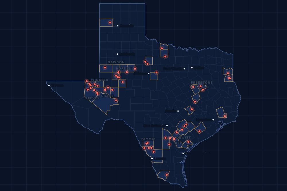
Counties and operators
Who drills, and where
Each county links to its Well Watch page, with its own map and every permit of the last two years. Each operator links to its page.
By county
- 1Martin County29
- 2Webb County23
- 3Loving County19
- 4Reeves County10
- 5Dimmit County6
- 6Crane County4
- 7De Witt County4
- 8Winkler County4
- 9Atascosa County3
- 10Borden County3
- 11Ward County3
- 12Bee County2
- 13Dawson County2
- 14Freestone County2
- 15Haskell County2
And 22 more counties with fewer, in the list below.
By operator
- 1Diamondback E&P LLC21
- 2EOG Resources, Inc.13
- 3Mewbourne Oil Company12
- 4Anadarko E&P Onshore LLC8
- 5SM Energy Company8
- 6Pioneer Natural Res. USA, Inc.6
- 7Javelin Energy Partners Mgmt LLC5
- 8Devon Energy Production Co, L.P.4
- 9WPX Energy Permian, LLC4
- 10Blackbeard Operating, LLC3
- 11Highpeak Energy Holdings, LLC3
- 12Permian Resources Operating, LLC3
- 13VTX Energy Operating, LLC3
- 14Waterbridge Stateline LLC3
- 15Ageron Energy, LLC2
And 35 more operators with fewer.
Register · January 6–12, 2025
Every permit, newest first
As the state files them: the lease and well, the operator, the kind of permit and the depth. “On the map” opens the county's live map at the well's spot.
Friday, January 1051 permits
- Atascosa CountyThompson B Unit, well 5HEOG Resources, Inc. · new drill · horizontal · 10,500 ftPermit 0904643 · API 42-013-36212On the map
- Bee CountyLocust, well 1HRosewood Resources, Inc. · new drill · horizontal · 14,000 ftPermit 0905094 · API 42-025-34063On the map
- Bee CountyCicada, well 1HRosewood Resources, Inc. · new drill · horizontal · 14,000 ftPermit 0905092 · API 42-025-34062On the map
- Borden CountyJolene 68-80 B Unit, well L 6HHighpeak Energy Holdings, LLC · new drill · horizontal · 6,500 ftPermit 0904958 · API 42-033-32752On the map
- Borden CountyJolene 68-80 B Unit, well A 6HHighpeak Energy Holdings, LLC · new drill · horizontal · 6,500 ftPermit 0904957 · API 42-033-32751On the map
- Callahan CountyWylie L, well K 8Haskit, Kendall · new drill · vertical · 1,000 ftPermit 0904987 · API 42-059-37199On the map
- Dimmit CountyMoro Creek, well 2412HVerdun Oil & Gas LLC · new drill · horizontal · 7,400 ftPermit 0905093 · API 42-127-39004On the map
- Glasscock CountyGreen Hornet West, well 2Trilogy Operating, Inc. · recompletion · vertical · 11,000 ftPermit 0905075 · API 42-173-37816On the map
- Liberty CountyRayo Luna, well 1Bkverde Texas Development, LLC · new drill · vertical · 7,700 ftPermit 0905076 · API 42-291-32967On the map
- Loving CountyCicero 28-0-17-29 H, well 52HAAnadarko E&P Onshore LLC · new drill · horizontal · 12,000 ftPermit 0904997 · API 42-301-37234On the map
- Loving CountyCicero 28-0-17-29 G, well 51HAAnadarko E&P Onshore LLC · new drill · horizontal · 12,000 ftPermit 0904996 · API 42-301-37233On the map
- Loving CountyCicero 28-0-17-29 F, well 16HAAnadarko E&P Onshore LLC · new drill · horizontal · 13,000 ftPermit 0904995 · API 42-301-37231On the map
- Loving CountyCicero 28-0-17-29 E, well 15HAAnadarko E&P Onshore LLC · new drill · horizontal · 13,000 ftPermit 0904994 · API 42-301-37230On the map
- Loving CountyCicero 28-0-17-29 D, well 14HAAnadarko E&P Onshore LLC · new drill · horizontal · 13,000 ftPermit 0904993 · API 42-301-37229On the map
- Loving CountyCicero 28-0-17-29 C, well 13HAAnadarko E&P Onshore LLC · new drill · horizontal · 13,000 ftPermit 0904992 · API 42-301-37228On the map
- Loving CountyCicero 28-0-17-29 B, well 12HAAnadarko E&P Onshore LLC · new drill · horizontal · 13,000 ftPermit 0904990 · API 42-301-37226On the map
- Loving CountyCicero 28-0-17-29 A, well 11HAAnadarko E&P Onshore LLC · new drill · horizontal · 13,000 ftPermit 0904989 · API 42-301-37224On the map
- Martin CountyBlackgoldeneye 13-1 Unit 2, well 8WAEndeavor Energy Resources L.P. · new drill · horizontal · 9,000 ftPermit 0905059 · API 42-317-46605On the map
- Martin CountyBlackgoldeneye 13-1 Unit 2, well 3DNEndeavor Energy Resources L.P. · new drill · horizontal · 9,000 ftPermit 0905057 · API 42-317-46604On the map
- Martin CountyTrue Grit 16-17 J, well 21WBDiamondback E&P LLC · new drill · horizontal · 13,000 ftPermit 0904722 · API 42-317-46566On the map
- Martin CountyTrue Grit 16-17 D, well 14WADiamondback E&P LLC · new drill · horizontal · 13,000 ftPermit 0904721 · API 42-317-46565On the map
- Martin CountyTrue Grit 16-17 G, well 18WBDiamondback E&P LLC · new drill · horizontal · 13,000 ftPermit 0904719 · API 42-317-46563On the map
- Martin CountyTrue Grit 16-17 G, well 7LSDiamondback E&P LLC · new drill · horizontal · 13,000 ftPermit 0904718 · API 42-317-46562On the map
- Martin CountyTrue Grit 16-17 F, well 17WADiamondback E&P LLC · new drill · horizontal · 13,000 ftPermit 0904717 · API 42-317-46561On the map
- Martin CountyTrue Grit 16-17 A, well 16WADiamondback E&P LLC · new drill · horizontal · 13,000 ftPermit 0904715 · API 42-317-46559On the map
- Martin CountyTrue Grit 16-17 A, well 1MSDiamondback E&P LLC · new drill · horizontal · 13,000 ftPermit 0904714 · API 42-317-46558On the map
- Martin CountySimons-Elrod 34N, well 14HPioneer Natural Res. USA, Inc. · new drill · horizontal · 9,800 ftPermit 0904684 · API 42-317-46557On the map
- Martin CountySimons-Elrod 34M, well 13HPioneer Natural Res. USA, Inc. · new drill · horizontal · 9,800 ftPermit 0904682 · API 42-317-46556On the map
- Martin CountySimons-Elrod 34L, well 12HPioneer Natural Res. USA, Inc. · new drill · horizontal · 9,800 ftPermit 0904681 · API 42-317-46555On the map
- Martin CountySimons-Elrod 34K, well 11HPioneer Natural Res. USA, Inc. · new drill · horizontal · 9,800 ftPermit 0904680 · API 42-317-46554On the map
- Martin CountySimons-Elrod 34J, well 10HPioneer Natural Res. USA, Inc. · new drill · horizontal · 9,800 ftPermit 0904678 · API 42-317-46553On the map
- Martin CountySimons-Elrod 34I, well 9HPioneer Natural Res. USA, Inc. · new drill · horizontal · 9,800 ftPermit 0904677 · API 42-317-46552On the map
- Martin CountyFenwick 10-3 M, well 13WDDiamondback E&P LLC · new drill · horizontal · 10,200 ftPermit 0904623 · API 42-317-46545On the map
- Martin CountyFenwick 10-3 J, well 10WBDiamondback E&P LLC · new drill · horizontal · 10,200 ftPermit 0904619 · API 42-317-46544On the map
- Martin CountyFenwick 10-3 G, well 7WADiamondback E&P LLC · new drill · horizontal · 10,200 ftPermit 0904617 · API 42-317-46543On the map
- Martin CountyFenwick 10-3 D, well 4LSDiamondback E&P LLC · new drill · horizontal · 10,200 ftPermit 0904613 · API 42-317-46542On the map
- Martin CountyFenwick 10-3 C, well 12MSDiamondback E&P LLC · new drill · horizontal · 10,200 ftPermit 0904605 · API 42-317-46541On the map
- Martin CountyFenwick 10-3 C, well 9WBDiamondback E&P LLC · new drill · horizontal · 10,200 ftPermit 0904597 · API 42-317-46540On the map
- Martin CountyFenwick 10-3 C, well 6WADiamondback E&P LLC · new drill · horizontal · 10,200 ftPermit 0904594 · API 42-317-46539On the map
- Martin CountyFenwick 10-3 C, well 3LSDiamondback E&P LLC · new drill · horizontal · 10,200 ftPermit 0904592 · API 42-317-46538On the map
- Martin CountyFenwick 10-3 B, well 11WBDiamondback E&P LLC · new drill · horizontal · 10,200 ftPermit 0904591 · API 42-317-46537On the map
- Martin CountyFenwick 10-3 B, well 8WADiamondback E&P LLC · new drill · horizontal · 10,200 ftPermit 0904590 · API 42-317-46536On the map
- Martin CountyFenwick 10-3 B, well 5LSDiamondback E&P LLC · new drill · horizontal · 10,200 ftPermit 0904589 · API 42-317-46535On the map
- Martin CountyFenwick 10-3 B, well 2JMDiamondback E&P LLC · new drill · horizontal · 10,200 ftPermit 0904588 · API 42-317-46534On the map
- Martin CountyFenwick 10-3 A, well 1JMDiamondback E&P LLC · new drill · horizontal · 10,200 ftPermit 0904587 · API 42-317-46533On the map
- Pecos CountyYates Field Unit, well 53G10Kinder Morgan Production Co LLC · recompletion · horizontal · 1,999 ftPermit 0905053 · API 42-371-35034On the map
- Reeves CountyProvidence, well 6HZLakewood Energy LLC · new drill · horizontal · 13,000 ftPermit 0904933 · API 42-389-41545On the map
- Winkler CountyUl American Basin 14-11-2C, well 413HWPX Energy Permian, LLC · new drill · horizontal · 14,000 ftPermit 0904568 · API 42-495-35045On the map
- Winkler CountyUl American Basin 14-11-2B, well 412HWPX Energy Permian, LLC · new drill · horizontal · 14,000 ftPermit 0904567 · API 42-495-35044On the map
- Winkler CountyUl American Basin 14-11-2D, well 414HWPX Energy Permian, LLC · new drill · horizontal · 14,000 ftPermit 0904566 · API 42-495-35046On the map
- Winkler CountyUl American Basin 14-11-2A, well 411HWPX Energy Permian, LLC · new drill · horizontal · 14,000 ftPermit 0904565 · API 42-495-35043On the map
Thursday, January 942 permits
- Crane CountyWaterlogged, well 23SDNile Midstream, LLC · new drill · vertical · 7,999 ftPermit 0905041 · API 42-103-37570On the map
- Dawson CountyRobyn Lee B, well 2HHibernia Resources IV, LLC · new drill · horizontal · 9,000 ftPermit 0905027 · API 42-115-34043On the map
- Dawson CountyRobyn Lee A, well 1HHibernia Resources IV, LLC · new drill · horizontal · 9,000 ftPermit 0905025 · API 42-115-34042On the map
- Dimmit CountyBriscoe Carla Ranch, well 102HZJavelin Energy Partners Mgmt LLC · new drill · horizontal · 9,000 ftPermit 0905064 · API 42-127-39003On the map
- Dimmit CountyBriscoe Carla Ranch, well 102HYJavelin Energy Partners Mgmt LLC · new drill · horizontal · 9,000 ftPermit 0905063 · API 42-127-39002On the map
- Dimmit CountyBriscoe Carla Ranch, well 102HXJavelin Energy Partners Mgmt LLC · new drill · horizontal · 9,000 ftPermit 0905062 · API 42-127-39001On the map
- Dimmit CountyBriscoe Carla Ranch, well 102HWJavelin Energy Partners Mgmt LLC · new drill · horizontal · 9,000 ftPermit 0905060 · API 42-127-39000On the map
- Dimmit CountyBriscoe Carla Ranch, well 102HVJavelin Energy Partners Mgmt LLC · new drill · horizontal · 9,000 ftPermit 0905058 · API 42-127-38999On the map
- Freestone CountyBaker, well 101HMitsui E&P USA LLC · new drill · horizontal · 30,000 ftPermit 0904999 · API 42-161-34869On the map
- Freestone CountySneed Gas Unit, well 5Hilcorp Energy Company · recompletion · vertical · 11,402 ftPermit 0904965 · API 42-161-31448On the map
- Harrison CountyHarris, well 2Harleton Oil & Gas Inc. · recompletion · vertical · 10,240 ftPermit 0904983 · API 42-203-34451On the map
- Karnes CountyGussie Yanta, well 13HMagnolia Oil & Gas Operating LLC · new drill · horizontal · 11,500 ftPermit 0904561 · API 42-255-38210On the map
- Loving CountyJohnson Estate 57-T1-2, well B201DMMewbourne Oil Company · new drill · horizontal · 8,885 ftPermit 0905031 · API 42-301-37235On the map
- Loving CountyJohnson Estate 57-T1-2, well H301DMMewbourne Oil Company · new drill · horizontal · 9,455 ftPermit 0905030 · API 42-301-37232On the map
- Loving CountyJohnson Estate 57-T1-2, well H301CNMewbourne Oil Company · new drill · horizontal · 9,486 ftPermit 0905028 · API 42-301-37227On the map
- Loving CountyJohnson Estate 57-T1-2, well B201CNMewbourne Oil Company · new drill · horizontal · 8,928 ftPermit 0905024 · API 42-301-37225On the map
- Loving CountyJohnson Estate 57-T1-2, well H301BOMewbourne Oil Company · new drill · horizontal · 9,519 ftPermit 0905020 · API 42-301-37223On the map
- Loving CountyJohnson Estate 57-T1-2, well B201BOMewbourne Oil Company · new drill · horizontal · 8,978 ftPermit 0905018 · API 42-301-37222On the map
- Oldham CountyAlamosa 315, well 11LDX Operating Company, Llc. · new drill · vertical · 6,500 ftPermit 0904853 · API 42-359-30432On the map
- Panola CountyHull Unit A, well A 38Sheridan Production Co III, LLC · recompletion · vertical · 6,500 ftPermit 0905032 · API 42-365-32019On the map
- Panola CountyHull Unit B, well B 5Sheridan Production Co III, LLC · recompletion · vertical · 6,000 ftPermit 0904973 · API 42-365-32190On the map
- Reeves CountyWaha, well E711HVTX Energy Operating, LLC · new drill · horizontal · 11,000 ftPermit 0905023 · API 42-389-41555On the map
- Reeves CountyWaha, well E611HVTX Energy Operating, LLC · new drill · horizontal · 11,000 ftPermit 0905014 · API 42-389-41554On the map
- Reeves CountyWaha, well E610HVTX Energy Operating, LLC · new drill · horizontal · 11,000 ftPermit 0905008 · API 42-389-41553On the map
- Reeves CountyBoomstick State 12B, well 22BSBlue Arrow Operating, LLC · new drill · horizontal · 9,240 ftPermit 0904955 · API 42-389-41548On the map
- Reeves CountyBoomstick State 12A, well 12BSBlue Arrow Operating, LLC · new drill · horizontal · 9,240 ftPermit 0904954 · API 42-389-41547On the map
- Scurry CountyBadlands 48-29-10, well 1HBrowning Oil Company, Inc. · new drill · horizontal · 6,900 ftPermit 0905043 · API 42-415-35780On the map
- Starr CountyBentsen Bros. - State, well 12Merit Energy Company · recompletion · vertical · 17,450 ftPermit 0904745 · API 42-427-33918On the map
- Webb CountyBriscoe C (SA25), well 0059HSM Energy Company · new drill · horizontal · 7,000 ftPermit 0905051 · API 42-479-45298On the map
- Webb CountyBriscoe C (SA26), well 0048HSM Energy Company · new drill · horizontal · 7,000 ftPermit 0905050 · API 42-479-45297On the map
- Webb CountyBriscoe C (SA27), well 0069HSM Energy Company · new drill · horizontal · 7,000 ftPermit 0905049 · API 42-479-45296On the map
- Webb CountyBriscoe C (SA28), well 0038HSM Energy Company · new drill · horizontal · 7,000 ftPermit 0905048 · API 42-479-45295On the map
- Webb CountyAnejo E, well 105HEOG Resources, Inc. · new drill · horizontal · 9,900 ftPermit 0905047 · API 42-479-45294On the map
- Webb CountyAnejo D, well 104HEOG Resources, Inc. · new drill · horizontal · 9,900 ftPermit 0905046 · API 42-479-45293On the map
- Webb CountyAnejo C, well 103HEOG Resources, Inc. · new drill · horizontal · 9,900 ftPermit 0905045 · API 42-479-45292On the map
- Webb CountyAnejo K, well 10HEOG Resources, Inc. · new drill · horizontal · 10,500 ftPermit 0905040 · API 42-479-45291On the map
- Webb CountyAnejo J, well 9HEOG Resources, Inc. · new drill · horizontal · 10,500 ftPermit 0905039 · API 42-479-45290On the map
- Webb CountyAnejo H, well 8HEOG Resources, Inc. · new drill · horizontal · 10,500 ftPermit 0905038 · API 42-479-45289On the map
- Webb CountyAnejo G, well 7HEOG Resources, Inc. · new drill · horizontal · 10,500 ftPermit 0905036 · API 42-479-45288On the map
- Webb CountyAnejo F, well 6HEOG Resources, Inc. · new drill · horizontal · 10,500 ftPermit 0905035 · API 42-479-45287On the map
- Webb CountyAnejo E, well 5HEOG Resources, Inc. · new drill · horizontal · 10,500 ftPermit 0905033 · API 42-479-45286On the map
- Webb CountyCodigo, well 106HEOG Resources, Inc. · new drill · horizontal · 9,900 ftPermit 0905022 · API 42-479-45285On the map
Wednesday, January 812 permits
- Gonzales CountyCherry Bergey Selman SA5, well 5HMarathon Oil Ef LLC · new drill · horizontal · 22,000 ftPermit 0904554 · API 42-177-34760On the map
- Loving CountyJohnson Estate 57-T1-2, well B201APMewbourne Oil Company · new drill · horizontal · 8,998 ftPermit 0905012 · API 42-301-37221On the map
- Loving CountyJohnson Estate 57-T1-2, well H301APMewbourne Oil Company · new drill · horizontal · 9,547 ftPermit 0905000 · API 42-301-37220On the map
- McMullen CountyEast Mcmullen SWD, well 1Kimmeridge Texas Gas, LLC · new drill · vertical · 9,000 ftPermit 0905026 · API 42-311-37575On the map
- Reeves CountyState Baffin 44/41, well W201PAMewbourne Oil Company · new drill · horizontal · 10,959 ftPermit 0905004 · API 42-389-41552On the map
- Reeves CountyState Baffin 44/41, well W102OBMewbourne Oil Company · new drill · horizontal · 10,766 ftPermit 0905003 · API 42-389-41551On the map
- Reeves CountyState Baffin 44/41, well W102PAMewbourne Oil Company · new drill · horizontal · 10,780 ftPermit 0905002 · API 42-389-41549On the map
- Reeves CountyState Baffin 44/41, well W201OBMewbourne Oil Company · new drill · horizontal · 11,082 ftPermit 0905001 · API 42-389-41550On the map
- Refugio CountyO'Connor, well 84T-C Oil Company, LLC · recompletion · vertical · 5,904 ftPermit 0905011 · API 42-391-33271On the map
- Webb CountyCodigo, well 12HEOG Resources, Inc. · new drill · horizontal · 10,500 ftPermit 0905021 · API 42-479-45283On the map
- Webb CountyCodigo, well 11HEOG Resources, Inc. · new drill · horizontal · 10,500 ftPermit 0905017 · API 42-479-45284On the map
- Wharton CountyLilie, well 4Paloma Operating, LLC · new drill · vertical · 7,400 ftPermit 0904964 · API 42-481-35511On the map
Tuesday, January 726 permits
- Crane CountyWaddell Tr A, well 5440HBlackbeard Operating, LLC · new drill · horizontal · 7,999 ftPermit 0904985 · API 42-103-37569On the map
- Crane CountyWaddell Tr 1, well 3884Blackbeard Operating, LLC · new drill · vertical · 14,000 ftPermit 0904984 · API 42-103-37568On the map
- Crane CountyWaddell Tr A, well 4806HBlackbeard Operating, LLC · new drill · horizontal · 7,999 ftPermit 0904035 · API 42-103-37543On the map
- De Witt CountyWesthoff A - Pilgrim B Sa E, well 5HDevon Energy Production Co, L.P. · new drill · horizontal · 14,000 ftPermit 0904444 · API 42-123-35523On the map
- De Witt CountyWesthoff A - Janca A Sa C, well 3HDevon Energy Production Co, L.P. · new drill · horizontal · 14,000 ftPermit 0904440 · API 42-123-35524On the map
- De Witt CountyWesthoff A - Janca A Sa B, well 2HDevon Energy Production Co, L.P. · new drill · horizontal · 14,000 ftPermit 0904438 · API 42-123-35520On the map
- De Witt CountyWesthoff A - Pilgrim B Sa A, well 1HDevon Energy Production Co, L.P. · new drill · horizontal · 14,000 ftPermit 0904434 · API 42-123-35519On the map
- Gaines CountySeminole San Andres Unit, well 1516ROXY USA Inc. · new drill · vertical · 6,000 ftPermit 0904849 · API 42-165-38972On the map
- Haskell CountyDebbie, well 1Teal Exploration, LLC · new drill · vertical · 6,000 ftPermit 0904986 · API 42-207-33049On the map
- Haskell CountyOverby, well 1Petex · new drill · vertical · 5,400 ftPermit 0904982 · API 42-207-33048On the map
- Lee CountyCampbell Ef, well 3HSage Natural Resources LLC · new drill · horizontal · 8,500 ftPermit 0904978 · API 42-287-32798On the map
- Lee CountyCampbell Ef, well 2HSage Natural Resources LLC · new drill · horizontal · 8,500 ftPermit 0904972 · API 42-287-32797On the map
- Loving CountyLayla SWD, well 1Waterbridge Stateline LLC · new drill · vertical · 7,600 ftPermit 0904981 · API 42-301-37218On the map
- Loving CountyDoors SWD, well 1Waterbridge Stateline LLC · new drill · vertical · 7,600 ftPermit 0904980 · API 42-301-37219On the map
- Loving CountyMercury SWD, well 1Waterbridge Stateline LLC · new drill · vertical · 7,900 ftPermit 0904974 · API 42-301-36069On the map
- Martin CountyTrue Grit 16-17 F, well 6JMDiamondback E&P LLC · new drill · horizontal · 13,000 ftPermit 0904716 · API 42-317-46560On the map
- Robertson CountyAragorn B, well 2HWildfire Energy Operating LLC · new drill · horizontal · 7,500 ftPermit 0904966 · API 42-395-32114On the map
- Upton CountyBonnie 12, well 23BUSummit Petroleum LLC · new drill · horizontal · 9,500 ftPermit 0903911 · API 42-461-43033On the map
- Ward CountyJosh 201-202 Unit, well 222HPermian Resources Operating, LLC · new drill · horizontal · 12,000 ftPermit 0904833 · API 42-475-38912On the map
- Webb CountyBriscoe C, well 0049HSM Energy Company · new drill · horizontal · 7,000 ftPermit 0904979 · API 42-479-45282On the map
- Webb CountyBriscoe C, well 0028HSM Energy Company · new drill · horizontal · 7,000 ftPermit 0904977 · API 42-479-45281On the map
- Webb CountyBriscoe C, well 0039HSM Energy Company · new drill · horizontal · 7,000 ftPermit 0904976 · API 42-479-45280On the map
- Webb CountyBriscoe C, well 0018HSM Energy Company · new drill · horizontal · 7,000 ftPermit 0904975 · API 42-479-45279On the map
- Webb CountySrs Unit 2, well 105HAgeron Energy, LLC · new drill · horizontal · 12,000 ftPermit 0904447 · API 42-479-45269On the map
- Webb CountySrs Unit 1, well 104HAgeron Energy, LLC · new drill · horizontal · 12,000 ftPermit 0904442 · API 42-479-45268On the map
- Wichita CountyWaggoner, J & J Kma Unit, well 98R2q Operating LLC · new drill · vertical · 5,000 ftPermit 0904956 · API 42-485-46318On the map
Monday, January 69 permits
- Archer CountyAndrews Longley, well 3JMH Production, LLC · new drill · vertical · 5,200 ftPermit 0904969 · API 42-009-43376On the map
- Atascosa CountyJustin Tom 01 B, well 07HSilverbow Resources Oper, LLC · new drill · horizontal · 11,000 ftPermit 0904942 · API 42-013-36218On the map
- Atascosa CountyEdmund Tom 02 A, well 09HSilverbow Resources Oper, LLC · new drill · horizontal · 11,000 ftPermit 0904941 · API 42-013-36217On the map
- Borden CountyGuy Guffee 68-6 B Unit, well A 6HHighpeak Energy Holdings, LLC · new drill · horizontal · 6,500 ftPermit 0904959 · API 42-033-32750On the map
- Lavaca CountyElnath A, well 1HBaytex Energy USA, Inc. · new drill · horizontal · 14,500 ftPermit 0904904 · API 42-285-34314On the map
- Limestone CountyTIPPIE-6 R-5, well 1New Horizon Global, Inc. · new drill · vertical · 5,600 ftPermit 0904892 · API 42-293-32427On the map
- Ward CountyMary Grace 201-202 Unit, well 226HPermian Resources Operating, LLC · new drill · horizontal · 12,000 ftPermit 0904698 · API 42-475-38899On the map
- Ward CountyMary Grace 201-202 Unit, well 224HPermian Resources Operating, LLC · new drill · horizontal · 12,000 ftPermit 0904696 · API 42-475-38897On the map
- Webb CountyGates 05-D-10 A, well 2003HRosetta Resources Operating LP · new drill · horizontal · 8,000 ftPermit 0904328 · API 42-479-45258On the map
Cancelled permits are left out. To look a permit up at the source, use the Railroad Commission's drilling permit query with its permit number.
Archive
Earlier weeks
Each finished week, Monday to Sunday, has its own page that does not change. The feed gets one entry per week.
- Nov 9–15, 2026103
- Nov 2–8, 2026164
- Oct 26 – Nov 1, 2026242
- Oct 19–25, 2026215
- Oct 12–18, 2026147
- Oct 5–11, 2026166
- Sep 28 – Oct 4, 2026156
- Sep 21–27, 2026194
- Sep 14–20, 2026167
- Sep 7–13, 2026133
- Aug 31 – Sep 6, 2026182
- Aug 24–30, 2026118
Every week since January 1, 2024 (150 weeks)
2026
- Aug 17–23167
- Aug 10–16198
- Aug 3–9186
- Jul 27 – Aug 2143
- Jul 20–26170
- Jul 13–19117
- Jul 6–12194
- Jun 29 – Jul 5114
- Jun 22–28175
- Jun 15–21186
- Jun 8–14187
- Jun 1–7154
- May 25–31158
- May 18–24197
- May 11–17182
- May 4–10190
- Apr 27 – May 3156
- Apr 20–26210
- Apr 13–19133
- Apr 6–12206
- Mar 30 – Apr 5129
- Mar 23–29159
- Mar 16–22167
- Mar 9–15166
- Mar 2–8140
- Feb 23 – Mar 1181
- Feb 16–22141
- Feb 9–15133
- Feb 2–8124
- Jan 26 – Feb 1126
- Jan 19–25189
- Jan 12–18280
- Jan 5–11129
2025
- Dec 29 – Jan 4, 202656
- Dec 22–2846
- Dec 15–21154
- Dec 8–14119
- Dec 1–7128
- Nov 24–3061
- Nov 17–23140
- Nov 10–1698
- Nov 3–9107
- Oct 27 – Nov 2137
- Oct 20–26145
- Oct 13–19173
- Oct 6–12206
- Sep 29 – Oct 5124
- Sep 22–28141
- Sep 15–21165
- Sep 8–14127
- Sep 1–7105
- Aug 25–31145
- Aug 18–24115
- Aug 11–17140
- Aug 4–10131
- Jul 28 – Aug 3134
- Jul 21–27151
- Jul 14–20151
- Jul 7–13148
- Jun 30 – Jul 6148
- Jun 23–29167
- Jun 16–22118
- Jun 9–15115
- Jun 2–8147
- May 26 – Jun 190
- May 19–25148
- May 12–18120
- May 5–11114
- Apr 28 – May 4135
- Apr 21–27182
- Apr 14–20115
- Apr 7–13197
- Mar 31 – Apr 6194
- Mar 24–30170
- Mar 17–23189
- Mar 10–16177
- Mar 3–9141
- Feb 24 – Mar 2172
- Feb 17–23145
- Feb 10–16170
- Feb 3–9167
- Jan 27 – Feb 2149
- Jan 20–26158
- Jan 13–19176
- Jan 6–12140
2024
- Dec 30 – Jan 5, 202597
- Dec 23–295
- Dec 16–22168
- Dec 9–15202
- Dec 2–8182
- Nov 25 – Dec 189
- Nov 18–24189
- Nov 11–17145
- Nov 4–10152
- Oct 28 – Nov 3134
- Oct 21–27163
- Oct 14–20147
- Oct 7–13114
- Sep 30 – Oct 6138
- Sep 23–29133
- Sep 16–22175
- Sep 9–15144
- Sep 2–8138
- Aug 26 – Sep 1177
- Aug 19–25207
- Aug 12–18186
- Aug 5–11145
- Jul 29 – Aug 4191
- Jul 22–28174
- Jul 15–21164
- Jul 8–14205
- Jul 1–7106
- Jun 24–30183
- Jun 17–23192
- Jun 10–16161
- Jun 3–9176
- May 27 – Jun 2135
- May 20–26223
- May 13–19169
- May 6–12155
- Apr 29 – May 5191
- Apr 22–28224
- Apr 15–21200
- Apr 8–14157
- Apr 1–7149
- Mar 25–31102
- Mar 18–24130
- Mar 11–17228
- Mar 4–10178
- Feb 26 – Mar 3187
- Feb 19–25164
- Feb 12–18190
- Feb 5–11137
- Jan 29 – Feb 4177
- Jan 22–28172
- Jan 15–21107
- Jan 8–14251
- Jan 1–7148
FAQ
Questions people ask
What is a drilling permit?
Permission from the Railroad Commission of Texas to drill a well, or to re-enter or deepen an old one, at a stated spot and to a stated depth. An operator files for it before the rig comes; it lasts two years. Many permitted wells are drilled within months, some never are.
Is this week complete?
Yes. The state has issued permits on later days, so this week's list is closed. A permit the state cancels later drops off the list.
Some permits are not on the map. Why?
The map draws a permit at the well's surface location as the state files it. A new permit's location can take a few days to reach the state's files; until then it is listed here but not drawn.
Does a new permit near my land mean I will be paid?
No. A permit says where a well may be drilled, not whose minerals it will produce or who is paid. That depends on your lease, the unit the well is pooled in and the division order. If a well is drilled on or next to your tract, watch for a division order from the operator.
Can I get these by email or in a feed?
Yes. The feed on this page has one entry for each finished week, for any feed reader. For one county, an abstract or a lease, Texas Well Watch sends one email a week when the state files something new there; it is free with an account.
Sources
- Railroad Commission of Texas, drilling permit master and trailer, daily file (with latitudes and longitudes)www.rrc.texas.gov/resource-center/research/data-sets-available-for-download/ · loaded every night; newest permit on file November 19, 2026
- Railroad Commission of Texas, drilling permit query (one permit at the source)webapps.rrc.texas.gov/DP/initializePublicQueryAction.do · linked, not read
- US Census Bureau, cartographic boundary files (county lines), through the us-atlas package 3.0.1www.census.gov/geographies/mapping-files/time-series/geo/cartographic-boundary.html · built into the site with its well maps
- GeoNames, towns and their points (CC BY 4.0)www.geonames.org/ · built into the site with its town pages