
Railroad Commission of Texas · week of January 22, 2024
New Texas drilling permits, Jan 22–28, 2024
- 172permits issued
- 127horizontal
- 44counties
- 56operators
That week
Where the state permitted wells
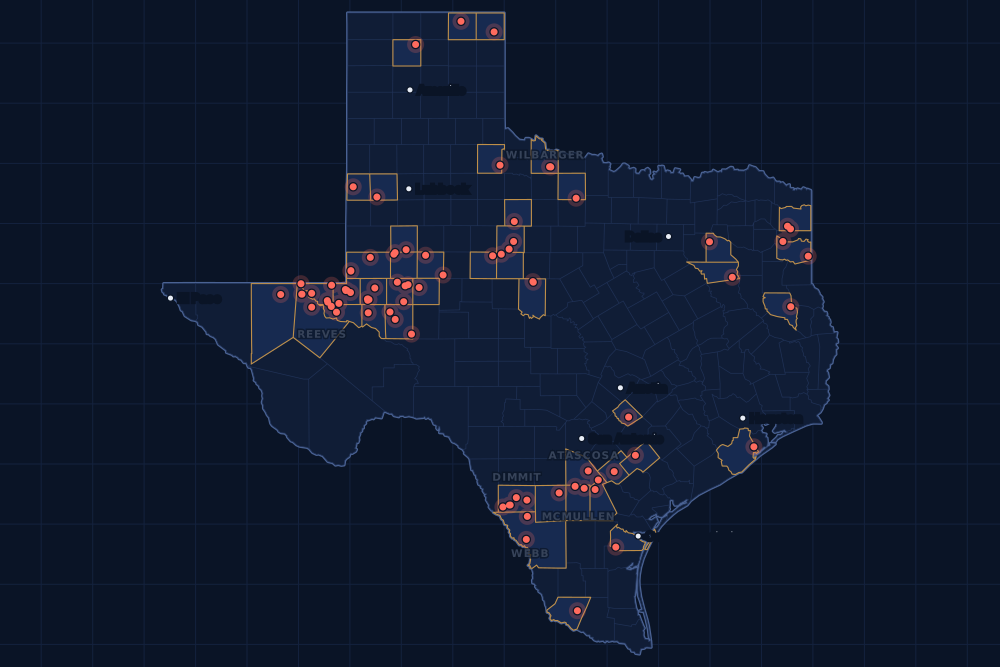
Counties and operators
Who drills, and where
Each county links to its Well Watch page, with its own map and every permit of the last two years. Each operator links to its page.
By county
- 1Dimmit County15
- 2Midland County15
- 3Reeves County15
- 4Martin County14
- 5Webb County10
- 6Loving County9
- 7Ector County8
- 8Wilbarger County8
- 9Winkler County8
- 10Atascosa County5
- 11McMullen County5
- 12Ward County5
- 13Howard County4
- 14Upton County4
- 15Andrews County3
And 29 more counties with fewer, in the list below.
By operator
- 1BPX Operating Company14
- 2Diamondback E&P LLC14
- 3Javelin Energy Partners Mgmt LLC11
- 4Chevron U. S. A. Inc.9
- 5EOG Resources, Inc.9
- 6Pioneer Natural Res. USA, Inc.8
- 7Ring Energy, Inc.8
- 8W.t. Waggoner Estate, Inc.8
- 9Anadarko E&P Onshore LLC6
- 10Marathon Oil Ef LLC6
- 11Basin Oil & Gas Operating, LLC4
- 12Kimmeridge Texas Gas, LLC4
- 13Silverbow Resources Oper, LLC4
- 14Sunoco Pipeline L.P.4
- 15Burlington Resources O & G Co LP3
And 41 more operators with fewer.
Register · January 22–28, 2024
Every permit, newest first
As the state files them: the lease and well, the operator, the kind of permit and the depth. “On the map” opens the county's live map at the well's spot.
Friday, January 2622 permits
- Andrews CountyBullhead 1, well 2NGL Water Solutions Permian, LLC · new drill · vertical · 6,300 ftPermit 0896863 · API 42-003-48899On the map
- Andrews CountyBullhead 1, well 1NGL Water Solutions Permian, LLC · new drill · vertical · 6,300 ftPermit 0896862 · API 42-003-48898On the map
- Atascosa CountyRetzloff-May-Tom SA1, well 01HMarathon Oil Ef LLC · new drill · horizontal · 24,000 ftPermit 0896649 · API 42-013-36133On the map
- Brazoria CountyDavid Young, well 1SElliott Oil & Gas Operating Co. · recompletion · vertical · 11,000 ftPermit 0896687 · API 42-039-33250On the map
- Coleman CountyHemphill 62A, well 3Window Operating Co., the · new drill · vertical · 3,999 ftPermit 0896679 · API 42-083-36278On the map
- Dimmit CountySpr-Ak A, well E920BHGrit Oil & Gas Management, LLC · new drill · horizontal · 6,500 ftPermit 0896838 · API 42-127-38885On the map
- Dimmit CountySpr-Ak B, well E922BHGrit Oil & Gas Management, LLC · new drill · horizontal · 6,500 ftPermit 0896837 · API 42-127-38884On the map
- Ector CountyAva Unit, well 1HAres Energy, Ltd. · new drill · horizontal · 12,500 ftPermit 0896802 · API 42-135-44032On the map
- Ector CountyMillard -K-, well 103Ring Energy, Inc. · new drill · vertical · 8,500 ftPermit 0896726 · API 42-135-44033On the map
- Haskell CountyDenson, well 1Petex · new drill · vertical · 5,250 ftPermit 0896818 · API 42-207-33035On the map
- Karnes CountyEscondido A B Usw F, well 1Burlington Resources O & G Co LP · new drill · horizontal · 17,500 ftPermit 0895800 · API 42-255-37910On the map
- Karnes CountyEscondido A B Usw E, well 1Burlington Resources O & G Co LP · new drill · horizontal · 17,500 ftPermit 0895798 · API 42-255-37909On the map
- Karnes CountyPaw-Escond-Mix Usw G, well 1Burlington Resources O & G Co LP · new drill · horizontal · 17,500 ftPermit 0895796 · API 42-255-37908On the map
- La Salle CountyNinja F, well 6HEOG Resources, Inc. · new drill · horizontal · 10,500 ftPermit 0896671 · API 42-283-37589On the map
- La Salle CountyNinja E, well 5HEOG Resources, Inc. · new drill · horizontal · 10,500 ftPermit 0896669 · API 42-283-37588On the map
- La Salle CountyNinja D, well 4HEOG Resources, Inc. · new drill · horizontal · 10,500 ftPermit 0896668 · API 42-283-37587On the map
- Loving CountyRen State 13-14G, well 305HWPX Energy Permian, LLC · new drill · horizontal · 14,000 ftPermit 0896783 · API 42-301-36737On the map
- Loving CountyRen State 13-14F, well 304HWPX Energy Permian, LLC · new drill · horizontal · 14,000 ftPermit 0896780 · API 42-301-36736On the map
- Loving CountyRen State 13-14E, well 303HWPX Energy Permian, LLC · new drill · horizontal · 14,000 ftPermit 0896776 · API 42-301-36735On the map
- McMullen CountyTyler Ranch Efs C, well 8HSilverbow Resources Oper, LLC · new drill · horizontal · 14,000 ftPermit 0896680 · API 42-311-37460On the map
- Upton CountyHerbert 102C, well 4HLOvintiv USA Inc. · new drill · horizontal · 10,300 ftPermit 0896616 · API 42-461-42701On the map
- Van Zandt CountyUnit 1263, well 1Boardwalk LA Midstream, LLC · new drill · vertical · 300 ftPermit 0896792 · API 42-467-31184On the map
Thursday, January 2547 permits
- Caldwell CountyDickerson, Claude, well 2BSGB Oil LLC · new drill · vertical · 3,000 ftPermit 0896693 · API 42-055-35187On the map
- Cass CountyDiamond, well 1HRose City Resources, LLC · new drill · horizontal · 13,000 ftPermit 0896519 · API 42-067-30932On the map
- Crane CountyWaddell Tr A, well 4518HBlackbeard Operating, LLC · new drill · horizontal · 7,999 ftPermit 0895849 · API 42-103-37412On the map
- Crane CountyWaddell Tr A, well 4040HBlackbeard Operating, LLC · new drill · horizontal · 7,999 ftPermit 0895828 · API 42-103-37409On the map
- Dawson CountyVaughn, well 1Burleson Petroleum, Inc. · re-entry · vertical · 10,000 ftPermit 0895875 · API 42-115-31299On the map
- De Witt CountyHartman A-Cantu A Sa 2, well 2HBPX Operating Company · new drill · horizontal · 14,000 ftPermit 0896660 · API 42-123-35364On the map
- De Witt CountyHartman A-Cantu A Sa 1, well 1HBPX Operating Company · new drill · horizontal · 14,000 ftPermit 0896659 · API 42-123-35362On the map
- Ector CountyScharbauer C, well 302Ring Energy, Inc. · new drill · vertical · 8,500 ftPermit 0896732 · API 42-135-44031On the map
- Ector CountyDown the Hatch SWD 17, well 1Ring Energy, Inc. · new drill · vertical · 9,999 ftPermit 0896718 · API 42-135-44027On the map
- Ector CountyGlub Glub SWD 24, well 1Ring Energy, Inc. · new drill · vertical · 9,999 ftPermit 0896715 · API 42-135-44028On the map
- Ector CountyOpen Wide SWD 14, well 1Ring Energy, Inc. · new drill · vertical · 9,999 ftPermit 0896714 · API 42-135-44026On the map
- Glasscock CountyPowell 0999OP, well 1HOXY USA Inc. · new drill · horizontal · 12,000 ftPermit 0896760 · API 42-173-39089On the map
- Jones CountyECT208, well 1Sunoco Pipeline L.P. · new drill · vertical · 400 ftPermit 0896711 · API 42-253-35720On the map
- Live Oak CountyThree Sisters 01, well 76HMarathon Oil Ef LLC · new drill · horizontal · 22,000 ftPermit 0896717 · API 42-297-36404On the map
- Live Oak CountyThree Sisters 01, well 75HMarathon Oil Ef LLC · new drill · horizontal · 22,000 ftPermit 0896716 · API 42-297-36403On the map
- Loving CountyVj Ranch Link 55-2 H, well 1573HPDEH LLC · new drill · horizontal · 13,000 ftPermit 0896094 · API 42-301-36688On the map
- Martin CountyCorretto 97-9 E, well 2JMDiamondback E&P LLC · new drill · horizontal · 13,000 ftPermit 0896738 · API 42-317-45848On the map
- Martin CountyCorretto 97-9 F, well 2WADiamondback E&P LLC · new drill · horizontal · 13,000 ftPermit 0896735 · API 42-317-45847On the map
- Martin CountyCorretto 97-9 C, well 1WBDiamondback E&P LLC · new drill · horizontal · 13,000 ftPermit 0896727 · API 42-317-45846On the map
- Martin CountyCorretto 97-9 B, well 1LSDiamondback E&P LLC · new drill · horizontal · 13,000 ftPermit 0896713 · API 42-317-45842On the map
- Martin CountyWalking on Water 14-24 C, well 2JMDiamondback E&P LLC · new drill · horizontal · 13,000 ftPermit 0896101 · API 42-317-45797On the map
- Martin CountyWalking on Water 14-24 B, well 1USDiamondback E&P LLC · new drill · horizontal · 13,000 ftPermit 0896099 · API 42-317-45796On the map
- Martin CountyWalking on Water 14-24 A, well 1MSDiamondback E&P LLC · new drill · horizontal · 13,000 ftPermit 0896098 · API 42-317-45795On the map
- McMullen CountyTyler Ranch Efs B, well 7HSilverbow Resources Oper, LLC · new drill · horizontal · 14,000 ftPermit 0896678 · API 42-311-37459On the map
- McMullen CountyTyler Ranch Efs A, well 6HSilverbow Resources Oper, LLC · new drill · horizontal · 14,000 ftPermit 0896677 · API 42-311-37458On the map
- McMullen CountyShannon-Tyler Ranch Efs, well 1HSilverbow Resources Oper, LLC · new drill · horizontal · 14,000 ftPermit 0896676 · API 42-311-37457On the map
- Midland CountyCmc Buttercup 25-37 Unit, well 0376WBChevron U. S. A. Inc. · new drill · horizontal · 11,405 ftPermit 0896724 · API 42-329-46776On the map
- Midland CountyCmc Buttercup 25-37 Unit, well 0375WCChevron U. S. A. Inc. · new drill · horizontal · 11,405 ftPermit 0896723 · API 42-329-46775On the map
- Midland CountyCmc Buttercup 25-37 Unit, well 0374WAChevron U. S. A. Inc. · new drill · horizontal · 11,405 ftPermit 0896722 · API 42-329-46774On the map
- Midland CountyCmc Buttercup 25-37 Unit, well 0373WBChevron U. S. A. Inc. · new drill · horizontal · 11,400 ftPermit 0896721 · API 42-329-46773On the map
- Midland CountyCmc Buttercup 25-37 Unit, well 0372WCChevron U. S. A. Inc. · new drill · horizontal · 11,405 ftPermit 0896720 · API 42-329-46772On the map
- Midland CountyCmc Buttercup 25-37 Unit, well 0371WAChevron U. S. A. Inc. · new drill · horizontal · 11,405 ftPermit 0896719 · API 42-329-46771On the map
- Midland CountyBuchanan C17G, well 7HPioneer Natural Res. USA, Inc. · new drill · horizontal · 10,300 ftPermit 0895844 · API 42-329-46739On the map
- Midland CountyBuchanan C17F, well 6HPioneer Natural Res. USA, Inc. · new drill · horizontal · 10,300 ftPermit 0895843 · API 42-329-46738On the map
- Midland CountyBuchanan W17E, well 5HPioneer Natural Res. USA, Inc. · new drill · horizontal · 10,300 ftPermit 0895842 · API 42-329-46737On the map
- Midland CountyBuchanan W17D, well 4HPioneer Natural Res. USA, Inc. · new drill · horizontal · 10,300 ftPermit 0895841 · API 42-329-46736On the map
- Midland CountyBuchanan W17C, well 3HPioneer Natural Res. USA, Inc. · new drill · horizontal · 10,300 ftPermit 0895840 · API 42-329-46735On the map
- Midland CountyBuchanan W17B, well 2HPioneer Natural Res. USA, Inc. · new drill · horizontal · 10,300 ftPermit 0895839 · API 42-329-46734On the map
- Midland CountyBuchanan W17A, well 1HPioneer Natural Res. USA, Inc. · new drill · horizontal · 10,300 ftPermit 0895838 · API 42-329-46733On the map
- Nolan CountyETC209, well 1Sunoco Pipeline L.P. · new drill · vertical · 400 ftPermit 0896712 · API 42-353-33750On the map
- Nueces CountyHlmw, well 1Paloma Operating, LLC · new drill · vertical · 7,800 ftPermit 0896763 · API 42-355-34223On the map
- Taylor CountyETC207, well 1Sunoco Pipeline L.P. · new drill · vertical · 400 ftPermit 0896710 · API 42-441-34691On the map
- Winkler CountyBaird, W. E., well 1902Basin Oil & Gas Operating, LLC · new drill · vertical · 7,800 ftPermit 0896686 · API 42-495-34953On the map
- Winkler CountyBaird, W. E., well 1809Basin Oil & Gas Operating, LLC · new drill · vertical · 7,800 ftPermit 0896685 · API 42-495-34952On the map
- Winkler CountyBaird, W. E., well 1802Basin Oil & Gas Operating, LLC · new drill · vertical · 7,800 ftPermit 0896684 · API 42-495-34951On the map
- Winkler CountyBaird, W. E., well 1304Basin Oil & Gas Operating, LLC · new drill · vertical · 7,800 ftPermit 0896683 · API 42-495-34950On the map
- Winkler CountyCop, well 742HBoyd & McWilliams Operating, LLC · new drill · horizontal · 8,300 ftPermit 0896654 · API 42-495-34945On the map
Wednesday, January 2445 permits
- Archer CountyAndrews, M.p. -C-, well 13Wilcox Energy Company LLC · new drill · vertical · 4,999 ftPermit 0896795 · API 42-009-43348On the map
- Atascosa CountyEsse-Retzloff-May-Tom SA1, well 01HMarathon Oil Ef LLC · new drill · horizontal · 24,000 ftPermit 0896650 · API 42-013-36132On the map
- Atascosa CountyEthridge Unit A, well 4HMarathon Oil Ef LLC · new drill · horizontal · 22,000 ftPermit 0896647 · API 42-013-36131On the map
- Atascosa CountyEthridge Unit A, well 3HMarathon Oil Ef LLC · new drill · horizontal · 22,000 ftPermit 0896646 · API 42-013-36130On the map
- Atascosa CountyRoad House Allocation, well 1HPillar Efs, LLC · new drill · horizontal · 9,000 ftPermit 0896514 · API 42-013-36129On the map
- Cass CountyLantz, well 1Barrow-Shaver Resources Co. · new drill · vertical · 12,000 ftPermit 0896460 · API 42-067-30931On the map
- Cochran CountyIke Clanton 'B', well 2HManzano, LLC · new drill · horizontal · 5,500 ftPermit 0896798 · API 42-079-33433On the map
- Coleman CountyHemphill 65, well 11Window Operating Co., the · new drill · vertical · 3,999 ftPermit 0896681 · API 42-083-36279On the map
- Cottle CountyFarmland Reserve, well 1Gunn Oil Company · new drill · vertical · 9,000 ftPermit 0896737 · API 42-101-30775On the map
- Culberson CountyTaylor Ranch State Unit, well 0055WAChevron U. S. A. Inc. · new drill · horizontal · 12,000 ftPermit 0896565 · API 42-109-34192On the map
- Culberson CountyTaylor Ranch State Unit, well 0053WAChevron U. S. A. Inc. · new drill · horizontal · 12,000 ftPermit 0896564 · API 42-109-34191On the map
- Culberson CountyTaylor Ranch State Unit, well 0051WAChevron U. S. A. Inc. · new drill · horizontal · 12,000 ftPermit 0896563 · API 42-109-34190On the map
- De Witt CountyHartman A-Cantu A Sa 3, well 3HBPX Operating Company · new drill · horizontal · 14,000 ftPermit 0896661 · API 42-123-35363On the map
- Dimmit CountyFrontschwein B Unit, well 1HVerdun Oil & Gas LLC · new drill · horizontal · 9,000 ftPermit 0896748 · API 42-127-38883On the map
- Dimmit CountyFrontschwein A Unit, well 1HVerdun Oil & Gas LLC · new drill · horizontal · 9,000 ftPermit 0896747 · API 42-127-38882On the map
- Harrison CountyWhelan Ou 1, well 1HUTanos Exploration IV, LLC · new drill · horizontal · 7,238 ftPermit 0896740 · API 42-203-35649On the map
- Henderson CountyJ.h. Dickerson, well 3Highmark Energy Operating, LLC · recompletion · vertical · 10,080 ftPermit 0896369 · API 42-213-30290On the map
- Howard CountyETC206, well 1Sunoco Pipeline L.P. · new drill · vertical · 400 ftPermit 0896708 · API 42-227-42377On the map
- Jones CountyBraun, well 1M. E. Operating & Services, Inc. · new drill · vertical · 3,500 ftPermit 0896662 · API 42-253-35719On the map
- Lipscomb CountyHostutler 451 A, well C001NCMewbourne Oil Company · new drill · horizontal · 8,315 ftPermit 0896626 · API 42-295-34412On the map
- Loving CountyZuma 57-T1-3X10 E, well W202CNMewbourne Oil Company · new drill · horizontal · 11,095 ftPermit 0896731 · API 42-301-36733On the map
- Loving CountyUl 19 Stonefly N, well 1572HPDEH LLC · new drill · horizontal · 12,700 ftPermit 0896725 · API 42-301-36734On the map
- Loving CountyZuma 57-T1-3X10 E, well W102DMMewbourne Oil Company · new drill · horizontal · 10,381 ftPermit 0896652 · API 42-301-36732On the map
- Loving CountyAvalanche 29-40 Unit, well 12HAnadarko E&P Onshore LLC · new drill · horizontal · 13,000 ftPermit 0896636 · API 42-301-36731On the map
- Loving CountyAvalanche 29-40 Unit, well 11HAnadarko E&P Onshore LLC · new drill · horizontal · 13,000 ftPermit 0896635 · API 42-301-36730On the map
- Martin CountyCorretto 97-9 I, well 1USDiamondback E&P LLC · new drill · horizontal · 13,000 ftPermit 0896664 · API 42-317-45841On the map
- McMullen CountyLocke Partnership B, well 2HGulftex Energy, LLC · new drill · horizontal · 10,000 ftPermit 0896501 · API 42-311-37453On the map
- Midland CountyMcclintic 11, well 1DPioneer Natural Res. USA, Inc. · new drill · vertical · 6,500 ftPermit 0896736 · API 42-329-46777On the map
- Reeves CountyBulldog State 55-4-12-7 F, well 12HAAnadarko E&P Onshore LLC · new drill · horizontal · 14,000 ftPermit 0896707 · API 42-389-41037On the map
- Reeves CountyBulldog State 55-4-12-7 E, well 23HAAnadarko E&P Onshore LLC · new drill · horizontal · 14,000 ftPermit 0896706 · API 42-389-41036On the map
- Reeves CountyBulldog State 55-4-12-7 D, well 21HAAnadarko E&P Onshore LLC · new drill · horizontal · 14,000 ftPermit 0896705 · API 42-389-41035On the map
- Reeves CountyBulldog State 55-4-12-7 C, well 11HAAnadarko E&P Onshore LLC · new drill · horizontal · 14,000 ftPermit 0896704 · API 42-389-41034On the map
- Reeves CountyState Ella Mae 57-T2-14X23 G, well W107HBPX Operating Company · new drill · horizontal · 11,995 ftPermit 0896599 · API 42-389-41033On the map
- Webb CountyRetama Ranch, well 422HKimmeridge Texas Gas, LLC · new drill · horizontal · 14,000 ftPermit 0896756 · API 42-479-45097On the map
- Webb CountyRetama Ranch, well 323HKimmeridge Texas Gas, LLC · new drill · horizontal · 14,000 ftPermit 0896755 · API 42-479-45096On the map
- Webb CountyRetama Ranch, well 123HKimmeridge Texas Gas, LLC · new drill · horizontal · 15,000 ftPermit 0896754 · API 42-479-45095On the map
- Webb CountyRetama Ranch, well 122HKimmeridge Texas Gas, LLC · new drill · horizontal · 15,000 ftPermit 0896752 · API 42-479-45094On the map
- Wilbarger CountyWaggoner Grayback Se, well 903SEW.t. Waggoner Estate, Inc. · new drill · vertical · 6,000 ftPermit 0896697 · API 42-487-33366On the map
- Wilbarger CountyWaggoner Grayback Se, well 821SEW.t. Waggoner Estate, Inc. · new drill · vertical · 6,000 ftPermit 0896691 · API 42-487-33364On the map
- Wilbarger CountyWaggoner Grayback Se, well 816SEW.t. Waggoner Estate, Inc. · new drill · vertical · 6,000 ftPermit 0896689 · API 42-487-33363On the map
- Wilbarger CountyWaggoner Grayback Se, well 804SEW.t. Waggoner Estate, Inc. · new drill · vertical · 6,000 ftPermit 0896688 · API 42-487-33362On the map
- Wilbarger CountyWaggoner Grayback Se, well 814SEW.t. Waggoner Estate, Inc. · new drill · vertical · 6,000 ftPermit 0896674 · API 42-487-33360On the map
- Wilbarger CountyWaggoner Grayback Se, well 813SEW.t. Waggoner Estate, Inc. · new drill · vertical · 6,000 ftPermit 0896673 · API 42-487-33359On the map
- Wilbarger CountyWaggoner Grayback Se, well 810SEW.t. Waggoner Estate, Inc. · new drill · vertical · 6,000 ftPermit 0896672 · API 42-487-33358On the map
- Wilbarger CountyWaggoner Grayback Se, well 809SEW.t. Waggoner Estate, Inc. · new drill · vertical · 6,000 ftPermit 0896670 · API 42-487-33357On the map
Tuesday, January 2337 permits
- Andrews CountyHomer, well 1HRing Energy, Inc. · new drill · horizontal · 5,500 ftPermit 0896511 · API 42-003-48895On the map
- Dimmit CountyBriscoe Catarina West, well 101HZJavelin Energy Partners Mgmt LLC · new drill · horizontal · 9,000 ftPermit 0896645 · API 42-127-38881On the map
- Dimmit CountyBriscoe Catarina West, well 101HYJavelin Energy Partners Mgmt LLC · new drill · horizontal · 9,000 ftPermit 0896644 · API 42-127-38880On the map
- Dimmit CountyBriscoe Catarina West, well 101HXJavelin Energy Partners Mgmt LLC · new drill · horizontal · 9,000 ftPermit 0896643 · API 42-127-38879On the map
- Dimmit CountyBriscoe Catarina West, well 101HWJavelin Energy Partners Mgmt LLC · new drill · horizontal · 9,000 ftPermit 0896642 · API 42-127-38878On the map
- Dimmit CountyBriscoe Catarina West, well 101HVJavelin Energy Partners Mgmt LLC · new drill · horizontal · 9,000 ftPermit 0896641 · API 42-127-38877On the map
- Dimmit CountyBriscoe Catarina West, well 101HUJavelin Energy Partners Mgmt LLC · new drill · horizontal · 9,000 ftPermit 0896640 · API 42-127-38876On the map
- Dimmit CountyBriscoe Catarina West, well 102HZJavelin Energy Partners Mgmt LLC · new drill · horizontal · 9,000 ftPermit 0896615 · API 42-127-38875On the map
- Dimmit CountyBriscoe Catarina West, well 102HYJavelin Energy Partners Mgmt LLC · new drill · horizontal · 9,000 ftPermit 0896613 · API 42-127-38874On the map
- Dimmit CountyBriscoe Catarina West, well 102HXJavelin Energy Partners Mgmt LLC · new drill · horizontal · 9,000 ftPermit 0896611 · API 42-127-38873On the map
- Dimmit CountyDiamond H State Unit B, well 102HBJavelin Energy Partners Mgmt LLC · new drill · horizontal · 9,000 ftPermit 0896523 · API 42-127-38871On the map
- Dimmit CountyDiamond H State Unit B, well 102HAJavelin Energy Partners Mgmt LLC · new drill · horizontal · 9,000 ftPermit 0896522 · API 42-127-38872On the map
- Ector CountyMillard -K-, well 102Ring Energy, Inc. · new drill · vertical · 8,500 ftPermit 0896709 · API 42-135-44025On the map
- Ector CountyMillard 'D', well 103Ring Energy, Inc. · new drill · vertical · 8,500 ftPermit 0896627 · API 42-135-44023On the map
- Harrison CountyFields-Isaacs Hv Unit G, well 7HRockcliff Energy Operating LLC · new drill · horizontal · 13,000 ftPermit 0896553 · API 42-203-35648On the map
- Howard CountyMr. Dynamite 41-44, well 6AVital Energy, Inc. · new drill · horizontal · 9,000 ftPermit 0896702 · API 42-227-42376On the map
- Howard CountyMr. Dynamite 41-44, well 4DNVital Energy, Inc. · new drill · horizontal · 9,000 ftPermit 0896701 · API 42-227-42375On the map
- Howard CountyMr. Dynamite 41-44, well 2DNVital Energy, Inc. · new drill · horizontal · 9,000 ftPermit 0896690 · API 42-227-42374On the map
- Martin CountyMojito 17-87 B, well 1LSDiamondback E&P LLC · new drill · horizontal · 13,000 ftPermit 0896658 · API 42-317-45839On the map
- Martin CountyMojito 17-87 H, well 2WADiamondback E&P LLC · new drill · horizontal · 13,000 ftPermit 0896655 · API 42-317-45838On the map
- Martin CountyMojito 17-87 D, well 1WADiamondback E&P LLC · new drill · horizontal · 13,000 ftPermit 0896653 · API 42-317-45837On the map
- Martin CountyMojito 17-87 A, well 1JMDiamondback E&P LLC · new drill · horizontal · 13,000 ftPermit 0896651 · API 42-317-45836On the map
- Martin CountyMojito 17-87 C, well 1USDiamondback E&P LLC · new drill · horizontal · 13,000 ftPermit 0896629 · API 42-317-45835On the map
- Martin CountyMojito 17-87 G, well 2MSDiamondback E&P LLC · new drill · horizontal · 13,000 ftPermit 0896610 · API 42-317-45834On the map
- Nacogdoches CountyClous Gas Unit, well 7HAethon Energy Operating LLC · new drill · horizontal · 14,420 ftPermit 0896618 · API 42-347-33504On the map
- Nacogdoches CountyClous Gas Unit, well 6HAethon Energy Operating LLC · new drill · horizontal · 14,420 ftPermit 0896617 · API 42-347-33503On the map
- Ochiltree CountyBusch, well 3HHadaway Consult and Engineer,llc · new drill · horizontal · 6,900 ftPermit 0896623 · API 42-357-33762On the map
- Starr CountyCameron-State, well 2Dahco Operating, LLC · new drill · vertical · 6,400 ftPermit 0896560 · API 42-427-34816On the map
- Ward CountyParker SWD, well 2Point Energy Partners Petro, LLC · new drill · vertical · 8,500 ftPermit 0896666 · API 42-475-38744On the map
- Ward CountyPep Wct Ranches SWD, well 1Point Energy Partners Petro, LLC · new drill · vertical · 8,500 ftPermit 0896665 · API 42-475-38743On the map
- Ward CountyCorbets A3, well 18HCallon Petroleum Operating Co · new drill · horizontal · 12,000 ftPermit 0896449 · API 42-475-38739On the map
- Webb CountyAnejo B, well 102HEOG Resources, Inc. · new drill · horizontal · 10,000 ftPermit 0896638 · API 42-479-45093On the map
- Webb CountyAnejo A, well 101HEOG Resources, Inc. · new drill · horizontal · 10,000 ftPermit 0896637 · API 42-479-45092On the map
- Webb CountyAnejo D, well 4HEOG Resources, Inc. · new drill · horizontal · 10,000 ftPermit 0896633 · API 42-479-45091On the map
- Webb CountyAnejo C, well 3HEOG Resources, Inc. · new drill · horizontal · 10,200 ftPermit 0896632 · API 42-479-45090On the map
- Webb CountyAnejo B, well 2HEOG Resources, Inc. · new drill · horizontal · 10,200 ftPermit 0896631 · API 42-479-45089On the map
- Webb CountyAnejo A, well 1HEOG Resources, Inc. · new drill · horizontal · 10,100 ftPermit 0896630 · API 42-479-45088On the map
Monday, January 2221 permits
- Hockley CountySlaughter, Bob, well 620Sabinal Energy Operating, LLC · new drill · vertical · 9,000 ftPermit 0896584 · API 42-219-37528On the map
- Midland CountyATE205, well 1Atmos Energy,west Texas Division · new drill · vertical · 360 ftPermit 0896403 · API 42-329-46770On the map
- Moore CountyKate, well 2J. W. Resources Inc. · new drill · vertical · 6,000 ftPermit 0896432 · API 42-341-33762On the map
- Reeves CountyState Ella Mae 57-T2-14X23 Bb, well W202HBPX Operating Company · new drill · horizontal · 11,995 ftPermit 0896608 · API 42-389-41032On the map
- Reeves CountyState Ella Mae 57-T2-14X23 Ba, well W201HBPX Operating Company · new drill · horizontal · 11,995 ftPermit 0896607 · API 42-389-41031On the map
- Reeves CountyState Ella Mae 57-T2-14X23 Ya, well X101HBPX Operating Company · new drill · horizontal · 11,995 ftPermit 0896606 · API 42-389-41030On the map
- Reeves CountyState Ella Mae 57-T2-14X23 Yb, well X102HBPX Operating Company · new drill · horizontal · 11,995 ftPermit 0896604 · API 42-389-41029On the map
- Reeves CountyState Ella Mae 57-T2-14X23 Bh, well W208HBPX Operating Company · new drill · horizontal · 11,995 ftPermit 0896603 · API 42-389-41028On the map
- Reeves CountyState Ella Mae 57-T2-14X23 Bg, well W207HBPX Operating Company · new drill · horizontal · 11,995 ftPermit 0896602 · API 42-389-41027On the map
- Reeves CountyState Ella Mae 57-T2-14X23 Yc, well X103HBPX Operating Company · new drill · horizontal · 11,995 ftPermit 0896601 · API 42-389-41026On the map
- Reeves CountyState Ella Mae 57-T2-14X23 H, well W108HBPX Operating Company · new drill · horizontal · 11,995 ftPermit 0896600 · API 42-389-41025On the map
- Reeves CountyState Ella Mae 57-T2-14X23 B, well W102HBPX Operating Company · new drill · horizontal · 11,995 ftPermit 0896598 · API 42-389-41024On the map
- Reeves CountyState Ella Mae 57-T2-14X23 A, well W101HBPX Operating Company · new drill · horizontal · 11,995 ftPermit 0896597 · API 42-389-41023On the map
- Upton CountyCindy 2413C, well 502HFirebird Energy II LLC · new drill · horizontal · 9,600 ftPermit 0896540 · API 42-461-42690On the map
- Upton CountyCindy 2413B, well 601HFirebird Energy II LLC · new drill · horizontal · 9,700 ftPermit 0896420 · API 42-461-42686On the map
- Upton CountyUl the Machine B 29-32-5, well 502UHIron Orchard Operating LLC · new drill · horizontal · 9,000 ftPermit 0896317 · API 42-461-42689On the map
- Ward CountyTadpolly 148, well 10BSCallon Petroleum Operating Co · new drill · horizontal · 12,000 ftPermit 0896595 · API 42-475-38742On the map
- Ward CountyCorbets A4, well 3LACallon Petroleum Operating Co · new drill · horizontal · 12,000 ftPermit 0896594 · API 42-475-38741On the map
- Winkler CountyUtl 4344-21, well 4505HJagged Peak Energy LLC · new drill · horizontal · 12,100 ftPermit 0896625 · API 42-495-34946On the map
- Winkler CountyUtl 4344-21, well 4503HJagged Peak Energy LLC · new drill · horizontal · 12,100 ftPermit 0896622 · API 42-495-34944On the map
- Winkler CountyUtl 4344-21, well 4502HJagged Peak Energy LLC · new drill · horizontal · 12,100 ftPermit 0896621 · API 42-495-34943On the map
Cancelled permits are left out. To look a permit up at the source, use the Railroad Commission's drilling permit query with its permit number.
Archive
Earlier weeks
Each finished week, Monday to Sunday, has its own page that does not change. The feed gets one entry per week.
- Nov 9–15, 2026103
- Nov 2–8, 2026164
- Oct 26 – Nov 1, 2026242
- Oct 19–25, 2026215
- Oct 12–18, 2026147
- Oct 5–11, 2026152
- Sep 28 – Oct 4, 2026156
- Sep 21–27, 2026194
- Sep 14–20, 2026167
- Sep 7–13, 2026133
- Aug 31 – Sep 6, 2026182
- Aug 24–30, 2026118
Every week since January 1, 2024 (150 weeks)
2026
- Aug 17–23167
- Aug 10–16198
- Aug 3–9186
- Jul 27 – Aug 2143
- Jul 20–26170
- Jul 13–19117
- Jul 6–12194
- Jun 29 – Jul 5114
- Jun 22–28175
- Jun 15–21186
- Jun 8–14187
- Jun 1–7154
- May 25–31158
- May 18–24197
- May 11–17182
- May 4–10190
- Apr 27 – May 3156
- Apr 20–26210
- Apr 13–19133
- Apr 6–12206
- Mar 30 – Apr 5129
- Mar 23–29159
- Mar 16–22167
- Mar 9–15166
- Mar 2–8140
- Feb 23 – Mar 1181
- Feb 16–22141
- Feb 9–15133
- Feb 2–8124
- Jan 26 – Feb 1126
- Jan 19–25189
- Jan 12–18280
- Jan 5–11129
2025
- Dec 29 – Jan 4, 202656
- Dec 22–2846
- Dec 15–21154
- Dec 8–14119
- Dec 1–7128
- Nov 24–3061
- Nov 17–23140
- Nov 10–1698
- Nov 3–9107
- Oct 27 – Nov 2137
- Oct 20–26145
- Oct 13–19173
- Oct 6–12206
- Sep 29 – Oct 5124
- Sep 22–28141
- Sep 15–21165
- Sep 8–14127
- Sep 1–7105
- Aug 25–31145
- Aug 18–24115
- Aug 11–17140
- Aug 4–10131
- Jul 28 – Aug 3134
- Jul 21–27151
- Jul 14–20151
- Jul 7–13148
- Jun 30 – Jul 6148
- Jun 23–29167
- Jun 16–22118
- Jun 9–15115
- Jun 2–8147
- May 26 – Jun 190
- May 19–25148
- May 12–18120
- May 5–11114
- Apr 28 – May 4135
- Apr 21–27182
- Apr 14–20115
- Apr 7–13197
- Mar 31 – Apr 6194
- Mar 24–30170
- Mar 17–23189
- Mar 10–16177
- Mar 3–9141
- Feb 24 – Mar 2172
- Feb 17–23145
- Feb 10–16170
- Feb 3–9167
- Jan 27 – Feb 2149
- Jan 20–26158
- Jan 13–19176
- Jan 6–12140
2024
- Dec 30 – Jan 5, 202597
- Dec 23–295
- Dec 16–22168
- Dec 9–15202
- Dec 2–8182
- Nov 25 – Dec 189
- Nov 18–24189
- Nov 11–17145
- Nov 4–10152
- Oct 28 – Nov 3134
- Oct 21–27163
- Oct 14–20147
- Oct 7–13114
- Sep 30 – Oct 6138
- Sep 23–29133
- Sep 16–22175
- Sep 9–15144
- Sep 2–8138
- Aug 26 – Sep 1177
- Aug 19–25207
- Aug 12–18186
- Aug 5–11145
- Jul 29 – Aug 4191
- Jul 22–28174
- Jul 15–21164
- Jul 8–14205
- Jul 1–7106
- Jun 24–30183
- Jun 17–23192
- Jun 10–16161
- Jun 3–9176
- May 27 – Jun 2135
- May 20–26223
- May 13–19169
- May 6–12155
- Apr 29 – May 5191
- Apr 22–28224
- Apr 15–21200
- Apr 8–14157
- Apr 1–7149
- Mar 25–31102
- Mar 18–24130
- Mar 11–17228
- Mar 4–10178
- Feb 26 – Mar 3187
- Feb 19–25164
- Feb 12–18190
- Feb 5–11137
- Jan 29 – Feb 4177
- Jan 22–28172
- Jan 15–21107
- Jan 8–14251
- Jan 1–7148
FAQ
Questions people ask
What is a drilling permit?
Permission from the Railroad Commission of Texas to drill a well, or to re-enter or deepen an old one, at a stated spot and to a stated depth. An operator files for it before the rig comes; it lasts two years. Many permitted wells are drilled within months, some never are.
Is this week complete?
Yes. The state has issued permits on later days, so this week's list is closed. A permit the state cancels later drops off the list.
Some permits are not on the map. Why?
The map draws a permit at the well's surface location as the state files it. A new permit's location can take a few days to reach the state's files; until then it is listed here but not drawn.
Does a new permit near my land mean I will be paid?
No. A permit says where a well may be drilled, not whose minerals it will produce or who is paid. That depends on your lease, the unit the well is pooled in and the division order. If a well is drilled on or next to your tract, watch for a division order from the operator.
Can I get these by email or in a feed?
Yes. The feed on this page has one entry for each finished week, for any feed reader. For one county, an abstract or a lease, Texas Well Watch sends one email a week when the state files something new there; it is free with an account.
Sources
- Railroad Commission of Texas, drilling permit master and trailer, daily file (with latitudes and longitudes)www.rrc.texas.gov/resource-center/research/data-sets-available-for-download/ · loaded every night; newest permit on file November 20, 2026
- Railroad Commission of Texas, drilling permit query (one permit at the source)webapps.rrc.texas.gov/DP/initializePublicQueryAction.do · linked, not read
- US Census Bureau, cartographic boundary files (county lines), through the us-atlas package 3.0.1www.census.gov/geographies/mapping-files/time-series/geo/cartographic-boundary.html · built into the site with its well maps
- GeoNames, towns and their points (CC BY 4.0)www.geonames.org/ · built into the site with its town pages