
Railroad Commission of Texas · week of January 1, 2024
New Texas drilling permits, Jan 1–7, 2024
- 148permits issued
- 116horizontal
- 34counties
- 46operators
That week
Where the state permitted wells
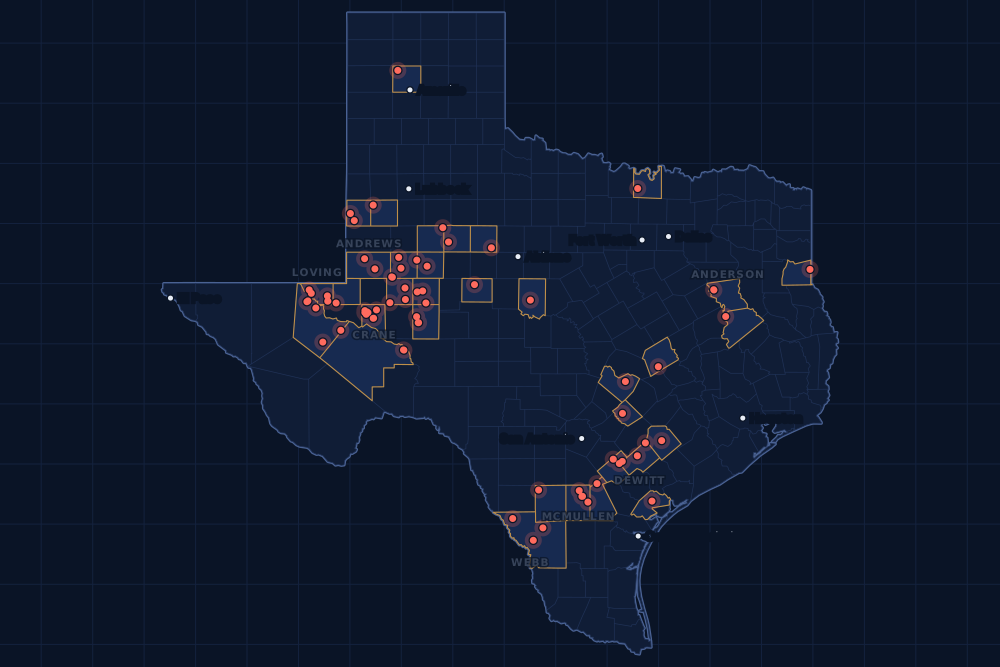
Counties and operators
Who drills, and where
Each county links to its Well Watch page, with its own map and every permit of the last two years. Each operator links to its page.
By county
- 1Midland County21
- 2Karnes County15
- 3Martin County15
- 4Crane County12
- 5Loving County12
- 6Reeves County11
- 7McMullen County8
- 8Anderson County5
- 9Reagan County5
- 10Webb County5
- 11Winkler County5
- 12Andrews County3
- 13De Witt County3
- 14Glasscock County3
- 15Yoakum County3
And 19 more counties with fewer, in the list below.
By operator
- 1Pioneer Natural Res. USA, Inc.14
- 2Anadarko E&P Onshore LLC10
- 3Blackbeard Operating, LLC10
- 4Burlington Resources O & G Co LP9
- 5Endeavor Energy Resources L.P.9
- 6Silverbow Resources Oper, LLC6
- 7Blackbrush O & G, LLC5
- 8Callon Petroleum Operating Co5
- 9Chevron U. S. A. Inc.5
- 10Lakewood Energy LLC5
- 11Trinity Gas Storage, LLC5
- 12Apache Corporation4
- 13Occidental Permian Ltd.4
- 14Repsol Oil & Gas USA, LLC4
- 15Civitas Permian Operating, LLC3
And 31 more operators with fewer.
Register · January 1–7, 2024
Every permit, newest first
As the state files them: the lease and well, the operator, the kind of permit and the depth. “On the map” opens the county's live map at the well's spot.
Friday, January 578 permits
- Anderson CountyTrinity Gas Storage Unit, well 4Trinity Gas Storage, LLC · new drill · vertical · 8,250 ftPermit 0896267 · API 42-001-32847On the map
- Anderson CountyTrinity Gas Storage Unit, well 3Trinity Gas Storage, LLC · new drill · vertical · 8,250 ftPermit 0896266 · API 42-001-32846On the map
- Anderson CountyTrinity Gas Storage Unit, well 2Trinity Gas Storage, LLC · new drill · vertical · 8,250 ftPermit 0896265 · API 42-001-32845On the map
- Anderson CountyTrinity Gas Storage Unit, well 1Trinity Gas Storage, LLC · new drill · vertical · 8,250 ftPermit 0896264 · API 42-001-32844On the map
- Anderson CountyTrinity Gas Storage Unit, well 5Trinity Gas Storage, LLC · new drill · vertical · 8,250 ftPermit 0896262 · API 42-001-32843On the map
- Andrews CountyUniversity 14SR, well 1404HRing Energy, Inc. · new drill · horizontal · 5,600 ftPermit 0896232 · API 42-003-48048On the map
- Andrews CountyUl G 1-4 B, well 2HElevation Resources LLC · new drill · horizontal · 15,000 ftPermit 0896220 · API 42-003-48891On the map
- Andrews CountyUl G 1-4 A, well 1HElevation Resources LLC · new drill · horizontal · 15,000 ftPermit 0896219 · API 42-003-48890On the map
- Caldwell CountyMetcalfe Oil Unit, well 3Cavalier Oil & Gas, Inc. · re-entry · vertical · 1,975 ftPermit 0895829 · API 42-055-33467On the map
- Crane CountyRing Barnsley B, well 3404MRing Energy, Inc. · new drill · vertical · 6,000 ftPermit 0896241 · API 42-103-37425On the map
- Crane CountyRing Barnsley A, well 3402MRing Energy, Inc. · new drill · vertical · 6,000 ftPermit 0896237 · API 42-103-37423On the map
- De Witt CountyAdamek Unit A, well 3HSilverbow Resources Oper, LLC · new drill · horizontal · 14,000 ftPermit 0896184 · API 42-123-35357On the map
- De Witt CountyAdamek Unit A, well 2HSilverbow Resources Oper, LLC · new drill · horizontal · 14,000 ftPermit 0896182 · API 42-123-35356On the map
- De Witt CountyNatho A, well 1HDevon Energy Production Co, L.P. · field transfer · horizontal · 14,000 ftPermit 0896174 · API 42-123-32429On the map
- Fisher CountyAncient 3-10E, well 1HCholla Petroleum, Inc. · new drill · horizontal · 7,999 ftPermit 0896259 · API 42-151-33350On the map
- Houston CountyShelby, well 2Big Creek Operating Company LLC · new drill · vertical · 2,000 ftPermit 0896257 · API 42-225-31429On the map
- Karnes CountyEcleto Partnership Unit B, well 11Burlington Resources O & G Co LP · new drill · horizontal · 17,500 ftPermit 0896282 · API 42-255-37945On the map
- Karnes CountyEcleto Partnership Unit B, well 10Burlington Resources O & G Co LP · new drill · horizontal · 17,500 ftPermit 0896281 · API 42-255-37944On the map
- Karnes CountyEcleto Partnership Unit B, well 5Burlington Resources O & G Co LP · new drill · horizontal · 17,500 ftPermit 0896280 · API 42-255-37943On the map
- Karnes CountyEcleto Partnership Unit B, well 3Burlington Resources O & G Co LP · new drill · horizontal · 17,500 ftPermit 0896279 · API 42-255-37942On the map
- Karnes CountyEcleto Partnership Unit B, well 2Burlington Resources O & G Co LP · new drill · horizontal · 17,500 ftPermit 0896278 · API 42-255-37941On the map
- Karnes CountyEcleto Partnership Unit A, well 10Burlington Resources O & G Co LP · new drill · horizontal · 17,500 ftPermit 0896276 · API 42-255-37940On the map
- Karnes CountyEcleto Partnership Unit A, well 9Burlington Resources O & G Co LP · new drill · horizontal · 17,500 ftPermit 0896275 · API 42-255-37939On the map
- Karnes CountyEcleto Partnership Unit A, well 8Burlington Resources O & G Co LP · new drill · horizontal · 17,500 ftPermit 0896274 · API 42-255-37938On the map
- Karnes CountyHunsaker Unit A, well 2Burlington Resources O & G Co LP · new drill · horizontal · 17,500 ftPermit 0896225 · API 42-255-37937On the map
- Live Oak CountyH T Chapman 02, well 201HSilverbow Resources Oper, LLC · new drill · horizontal · 14,000 ftPermit 0896229 · API 42-297-36401On the map
- Live Oak CountyGuy Phillip Wright A, well 202HSilverbow Resources Oper, LLC · new drill · horizontal · 14,000 ftPermit 0896228 · API 42-297-36402On the map
- Loving CountyBoz 55-2-6 Unit, well 13HAnadarko E&P Onshore LLC · new drill · horizontal · 12,000 ftPermit 0896272 · API 42-301-36710On the map
- Loving CountyBoz 55-2-6 Unit, well 12HAnadarko E&P Onshore LLC · new drill · horizontal · 12,000 ftPermit 0896271 · API 42-301-36709On the map
- Loving CountyTriple Pearl 29-0-23-26 C, well 13HAAnadarko E&P Onshore LLC · new drill · horizontal · 14,000 ftPermit 0896144 · API 42-301-35724On the map
- Loving CountyTriple Pearl 29-0-23-26 B, well 12HAAnadarko E&P Onshore LLC · new drill · horizontal · 14,000 ftPermit 0896142 · API 42-301-35723On the map
- Loving CountyTriple Pearl 29-0-23-26 A, well 11HAAnadarko E&P Onshore LLC · new drill · horizontal · 14,000 ftPermit 0896141 · API 42-301-35722On the map
- Loving CountyVj Ranch Link 55-2 G, well 1572HPDEH LLC · new drill · horizontal · 13,000 ftPermit 0896093 · API 42-301-36687On the map
- Loving CountyVj Ranch Link 55-2 F, well 1571HPDEH LLC · new drill · horizontal · 13,000 ftPermit 0896092 · API 42-301-36686On the map
- Martin CountyEasy Target 3099OP, well 6HOccidental Permian Ltd. · new drill · horizontal · 13,000 ftPermit 0896212 · API 42-317-45820On the map
- Martin CountyEasy Target 3001VP, well 5HOccidental Permian Ltd. · new drill · horizontal · 13,000 ftPermit 0896211 · API 42-317-45819On the map
- McMullen CountyWesley Swaim Unit-Ws (Sa) A6, well A 6HRepsol Oil & Gas USA, LLC · new drill · horizontal · 12,000 ftPermit 0896158 · API 42-311-37452On the map
- McMullen CountyWesley Swaim Unit-Ws (Sa) A5, well A 5HRepsol Oil & Gas USA, LLC · new drill · horizontal · 12,000 ftPermit 0896157 · API 42-311-37451On the map
- McMullen CountyPowersg-Wsu-Ws (Sa) A4, well A 4HRepsol Oil & Gas USA, LLC · new drill · horizontal · 12,000 ftPermit 0896156 · API 42-311-37447On the map
- McMullen CountyPowersg-Gs-Wsu-Ws-Mws (Sa) A3, well A 3HRepsol Oil & Gas USA, LLC · new drill · horizontal · 12,000 ftPermit 0896132 · API 42-311-37446On the map
- McMullen CountyBracken North C, well 5HRosewood Resources, Inc. · new drill · horizontal · 11,950 ftPermit 0896057 · API 42-311-37450On the map
- McMullen CountyBracken North B, well 4HRosewood Resources, Inc. · new drill · horizontal · 11,950 ftPermit 0896056 · API 42-311-37449On the map
- McMullen CountyBracken North A, well 3HRosewood Resources, Inc. · new drill · horizontal · 11,950 ftPermit 0896055 · API 42-311-37448On the map
- Midland CountyBusby, well 4HMApache Corporation · new drill · horizontal · 12,000 ftPermit 0896239 · API 42-329-46764On the map
- Midland CountyBusby, well 3HMApache Corporation · new drill · horizontal · 12,000 ftPermit 0896238 · API 42-329-46763On the map
- Midland CountyBusby, well 2HMApache Corporation · new drill · horizontal · 12,000 ftPermit 0896236 · API 42-329-46762On the map
- Midland CountyBusby, well 1HMApache Corporation · new drill · horizontal · 12,000 ftPermit 0896235 · API 42-329-46761On the map
- Midland CountyCrespi C30C, well 3HPioneer Natural Res. USA, Inc. · new drill · horizontal · 10,605 ftPermit 0895633 · API 42-329-46697On the map
- Midland CountyCrespi C30D, well 4HPioneer Natural Res. USA, Inc. · new drill · horizontal · 10,605 ftPermit 0895632 · API 42-329-46696On the map
- Midland CountyCrespi C30E, well 5HPioneer Natural Res. USA, Inc. · new drill · horizontal · 10,605 ftPermit 0895626 · API 42-329-46694On the map
- Midland CountyCrespi C30F, well 6HPioneer Natural Res. USA, Inc. · new drill · horizontal · 10,605 ftPermit 0895620 · API 42-329-46695On the map
- Midland CountyCrespi E30A, well 1HPioneer Natural Res. USA, Inc. · new drill · horizontal · 10,605 ftPermit 0895616 · API 42-329-46693On the map
- Midland CountyCrespi E30B, well 2HPioneer Natural Res. USA, Inc. · new drill · horizontal · 10,605 ftPermit 0895615 · API 42-329-46692On the map
- Midland CountyCrespi E30C, well 3HPioneer Natural Res. USA, Inc. · new drill · horizontal · 10,605 ftPermit 0895614 · API 42-329-46691On the map
- Midland CountyCrespi E30D, well 4HPioneer Natural Res. USA, Inc. · new drill · horizontal · 10,605 ftPermit 0895613 · API 42-329-46690On the map
- Midland CountyCrespi E30E, well 5HPioneer Natural Res. USA, Inc. · new drill · horizontal · 10,605 ftPermit 0895612 · API 42-329-46689On the map
- Milam CountyKrupesh, well 4Winchester Oil & Gas LLC · new drill · vertical · 2,000 ftPermit 0896233 · API 42-331-35130On the map
- Pecos CountyYates Field Unit, well 36A23Kinder Morgan Production Co LLC · recompletion · horizontal · 1,999 ftPermit 0896258 · API 42-371-32805On the map
- Reagan CountyHolly K, well 11HCivitas Permian Operating, LLC · new drill · horizontal · 11,000 ftPermit 0895947 · API 42-383-41662On the map
- Reeves CountyDbm 56-3-43, well 2DWes Water Holdings LLC · new drill · vertical · 6,150 ftPermit 0896289 · API 42-389-41004On the map
- Reeves CountyDbm 56-3-19, well 2DWes Water Holdings LLC · new drill · vertical · 6,150 ftPermit 0896285 · API 42-389-41002On the map
- Reeves CountyDbm 56-3-19, well 1DWes Water Holdings LLC · new drill · vertical · 6,150 ftPermit 0896283 · API 42-389-40999On the map
- Reeves CountyProvidence, well 5HLakewood Energy LLC · new drill · horizontal · 13,000 ftPermit 0896179 · API 42-389-40992On the map
- Reeves CountyProvidence, well 4HLakewood Energy LLC · new drill · horizontal · 13,000 ftPermit 0896178 · API 42-389-40991On the map
- Reeves CountyProvidence, well 3HLakewood Energy LLC · new drill · horizontal · 13,000 ftPermit 0896177 · API 42-389-40990On the map
- Reeves CountyProvidence, well 2HLakewood Energy LLC · new drill · horizontal · 13,000 ftPermit 0896176 · API 42-389-40989On the map
- Reeves CountyProvidence, well 1HLakewood Energy LLC · new drill · horizontal · 13,000 ftPermit 0896175 · API 42-389-40988On the map
- Reeves CountySandy E, well 3AVital Energy, Inc. · new drill · horizontal · 11,000 ftPermit 0896065 · API 42-389-40987On the map
- Reeves CountyGiraffe 19 Unit S21, well 21HVTX Energy Operating, LLC · new drill · horizontal · 13,000 ftPermit 0895930 · API 42-389-40973On the map
- Refugio CountyTom O'Connor (5730 Ft. Sd) Unit, well A 27Hilcorp Energy Company · recompletion · vertical · 5,925 ftPermit 0896222 · API 42-391-00435On the map
- Travis CountySamsung Meter Site, well 1Enterprise Products Texas Op LLC · new drill · vertical · 375 ftPermit 0896213 · API 42-453-30389On the map
- Webb CountyReuthinger, well R104HKimmeridge Texas Gas, LLC · new drill · horizontal · 15,000 ftPermit 0896260 · API 42-479-45072On the map
- Webb CountyPge Dos, well E 2HSilverbow Resources Oper, LLC · new drill · horizontal · 9,000 ftPermit 0896223 · API 42-479-45071On the map
- Webb CountyPge Dos, well E 1HSilverbow Resources Oper, LLC · new drill · horizontal · 9,000 ftPermit 0896203 · API 42-479-45069On the map
- Winkler CountyUl Sugarloaf A5, well 20HCallon Petroleum Operating Co · new drill · horizontal · 12,400 ftPermit 0896247 · API 42-495-34938On the map
- Winkler CountyUl Sugarloaf A4, well 32BSCallon Petroleum Operating Co · new drill · horizontal · 12,400 ftPermit 0896246 · API 42-495-34937On the map
- Winkler CountyUl Sugarloaf A3, well 6LACallon Petroleum Operating Co · new drill · horizontal · 12,400 ftPermit 0896245 · API 42-495-34936On the map
- Winkler CountyUl Sugarloaf A2, well 31BSCallon Petroleum Operating Co · new drill · horizontal · 12,400 ftPermit 0896244 · API 42-495-34935On the map
Thursday, January 412 permits
- Coleman CountyLazy I Ranch, well 1Flint Rock Resources Mgmnt, Inc. · new drill · vertical · 2,500 ftPermit 0895966 · API 42-083-36277On the map
- Crane CountyWaddell Tr 3, well 0741Blackbeard Operating, LLC · recompletion · vertical · 9,325 ftPermit 0896205 · API 42-103-01595On the map
- Crane CountyLandlubber, well 96Blackbeard Operating, LLC · new drill · vertical · 7,999 ftPermit 0896202 · API 42-103-37424On the map
- Glasscock CountyCerro Gordo, well 1DCrownquest Operating, LLC · new drill · vertical · 3,870 ftPermit 0896227 · API 42-173-39088On the map
- Karnes CountyMzyk North Unit, well 12HBlackbrush O & G, LLC · new drill · horizontal · 10,000 ftPermit 0896050 · API 42-255-37932On the map
- Martin CountyEasy Target 3097OP, well 4HOccidental Permian Ltd. · new drill · horizontal · 13,000 ftPermit 0896210 · API 42-317-45818On the map
- Martin CountyEasy Target 1991OP, well 1HOccidental Permian Ltd. · new drill · horizontal · 13,000 ftPermit 0896207 · API 42-317-45815On the map
- Midland CountyCrespi E30F, well 6HPioneer Natural Res. USA, Inc. · new drill · horizontal · 10,605 ftPermit 0895611 · API 42-329-46688On the map
- Panola CountyPermenter SWD, well 1Panola Operating LLC · new drill · vertical · 8,900 ftPermit 0896042 · API 42-365-38895On the map
- Potter CountyExell Ranch, well 5302Sunlight Exploration, Inc. · new drill · vertical · 9,000 ftPermit 0896224 · API 42-375-31940On the map
- Reeves CountyGiraffe 19 Unit S32, well 32HVTX Energy Operating, LLC · new drill · horizontal · 13,000 ftPermit 0895935 · API 42-389-40996On the map
- Scurry CountyLion Diamond 'M' Unit, well J 9Kinder Morgan Production Co LLC · re-entry · vertical · 7,800 ftPermit 0896243 · API 42-415-01397On the map
Wednesday, January 329 permits
- Crane CountyWaddell Tr A, well 5042HBlackbeard Operating, LLC · new drill · horizontal · 7,999 ftPermit 0895496 · API 42-103-37396On the map
- Crane CountyWaddell Tr A, well 5600HBlackbeard Operating, LLC · new drill · horizontal · 7,999 ftPermit 0895476 · API 42-103-37395On the map
- Crane CountyWaddell Tr A, well 5407HBlackbeard Operating, LLC · new drill · horizontal · 7,999 ftPermit 0895460 · API 42-103-37393On the map
- Crane CountyWaddell Tr A, well 4055HBlackbeard Operating, LLC · new drill · horizontal · 7,999 ftPermit 0895453 · API 42-103-37392On the map
- Crane CountyWaddell Tr A, well 5411HBlackbeard Operating, LLC · new drill · horizontal · 7,999 ftPermit 0895433 · API 42-103-37391On the map
- Crane CountyWaddell Tr A, well 4090HBlackbeard Operating, LLC · new drill · horizontal · 7,999 ftPermit 0895383 · API 42-103-37389On the map
- Crane CountyWaddell Tr A, well 1171Blackbeard Operating, LLC · recompletion · vertical · 7,999 ftPermit 0895254 · API 42-103-32269On the map
- Glasscock CountyHuling 36-37 C, well 231Endeavor Energy Resources L.P. · new drill · horizontal · 8,802 ftPermit 0894503 · API 42-173-39066On the map
- Loving CountyHelga 19-0-4-40 E, well 15HAnadarko E&P Onshore LLC · new drill · horizontal · 13,000 ftPermit 0896201 · API 42-301-36703On the map
- Loving CountyHelga 19-0-4-40 D, well 14HAnadarko E&P Onshore LLC · new drill · horizontal · 13,000 ftPermit 0896200 · API 42-301-36705On the map
- Loving CountyHelga 19-0-4-40 C, well 13HAnadarko E&P Onshore LLC · new drill · horizontal · 13,000 ftPermit 0896199 · API 42-301-36702On the map
- Loving CountyHelga 19-0-4-40 B, well 12HAnadarko E&P Onshore LLC · new drill · horizontal · 13,000 ftPermit 0896198 · API 42-301-36701On the map
- Loving CountyHelga 19-0-4-40 A, well 11HAnadarko E&P Onshore LLC · new drill · horizontal · 13,000 ftPermit 0896197 · API 42-301-36699On the map
- Martin CountyElias 16-9 D, well 143Endeavor Energy Resources L.P. · new drill · horizontal · 11,000 ftPermit 0896160 · API 42-317-45800On the map
- Martin CountyPresidio 254F, well 105HJOvintiv USA Inc. · new drill · horizontal · 10,500 ftPermit 0895486 · API 42-317-45782On the map
- Martin CountyPresidio 254F, well 104HROvintiv USA Inc. · new drill · horizontal · 10,500 ftPermit 0895485 · API 42-317-45781On the map
- Martin CountyPresidio 254F, well 103HDOvintiv USA Inc. · new drill · horizontal · 10,500 ftPermit 0895484 · API 42-317-45780On the map
- McMullen CountyRyan Island, well 1HKimmeridge Texas Gas, LLC · new drill · horizontal · 15,000 ftPermit 0896067 · API 42-311-37434On the map
- Midland CountyCrespi C30A, well 1HPioneer Natural Res. USA, Inc. · new drill · horizontal · 10,605 ftPermit 0895639 · API 42-329-46699On the map
- Midland CountyCrespi C30B, well 2HPioneer Natural Res. USA, Inc. · new drill · horizontal · 10,605 ftPermit 0895636 · API 42-329-46698On the map
- Pecos CountyYates Field Unit, well 36D19Kinder Morgan Production Co LLC · recompletion · horizontal · 1,999 ftPermit 0896061 · API 42-371-32645On the map
- Reagan CountyAldwell-Bird 10G, well 207HPioneer Natural Res. USA, Inc. · new drill · horizontal · 8,537 ftPermit 0895557 · API 42-383-41619On the map
- Reagan CountyAldwell-Bird 10C, well 203HPioneer Natural Res. USA, Inc. · new drill · horizontal · 8,486 ftPermit 0895556 · API 42-383-41617On the map
- Webb CountyLm 1870 - Wnh D, well 106HEOG Resources, Inc. · new drill · horizontal · 13,300 ftPermit 0895974 · API 42-479-45070On the map
- Webb CountyLm 1870 - Wnh C, well 300HEOG Resources, Inc. · new drill · horizontal · 12,750 ftPermit 0895973 · API 42-479-45065On the map
- Winkler CountyUl Sugarloaf A1, well 19HCallon Petroleum Operating Co · new drill · horizontal · 12,400 ftPermit 0896140 · API 42-495-34934On the map
- Yoakum CountyRip Wheeler 705-668, well 6XHRiley Permian Operating Co, LLC · new drill · horizontal · 9,000 ftPermit 0896196 · API 42-501-37514On the map
- Yoakum CountyRip Wheeler 705-668, well 4XHRiley Permian Operating Co, LLC · new drill · horizontal · 9,000 ftPermit 0896195 · API 42-501-37513On the map
- Yoakum CountyNever Switch 451 A, well 4HSteward Energy II, LLC · new drill · horizontal · 5,600 ftPermit 0896025 · API 42-501-37511On the map
Tuesday, January 229 permits
- Borden CountyBeavers 580, well 1Browning Oil Company, Inc. · new drill · vertical · 8,500 ftPermit 0896204 · API 42-033-32672On the map
- Coke CountyL.b. Menielle, well 38Citation Oil & Gas Corp. · new drill · vertical · 6,300 ftPermit 0896015 · API 42-081-32142On the map
- Cooke CountyDangle, well 16WFW Production Company, Inc. · new drill · vertical · 2,999 ftPermit 0895588 · API 42-097-34813On the map
- Crane CountyWaddell Tr A, well 481Blackbeard Operating, LLC · recompletion · vertical · 7,999 ftPermit 0895205 · API 42-103-01938On the map
- Glasscock CountyPalo Alto, well 1DCrownquest Operating, LLC · new drill · vertical · 4,115 ftPermit 0896226 · API 42-173-39087On the map
- Howard CountyHoward Snell SWD, well 2NGL Water Solutions Permian, LLC · new drill · vertical · 12,000 ftPermit 0896218 · API 42-227-39131On the map
- Howard CountyHoward Snell SWD, well 1NGL Water Solutions Permian, LLC · new drill · vertical · 4,250 ftPermit 0896217 · API 42-227-39130On the map
- Karnes CountyMzyk North Unit, well 13HKimmeridge Texas Gas, LLC · new drill · horizontal · 11,000 ftPermit 0896051 · API 42-255-37933On the map
- Karnes CountyMzyk North Unit, well 11HBlackbrush O & G, LLC · new drill · horizontal · 10,000 ftPermit 0896049 · API 42-255-37931On the map
- Karnes CountyMzyk North Unit, well 10HBlackbrush O & G, LLC · new drill · horizontal · 10,000 ftPermit 0896047 · API 42-255-37930On the map
- Karnes CountyMzyk North Unit, well 9HBlackbrush O & G, LLC · new drill · horizontal · 10,000 ftPermit 0896046 · API 42-255-37929On the map
- Karnes CountyMzyk North Unit, well 8HBlackbrush O & G, LLC · new drill · horizontal · 10,000 ftPermit 0896045 · API 42-255-37928On the map
- La Salle CountyTalbutt West Rme B, well 2HRidgemar Energy Operating, LLC · new drill · horizontal · 8,000 ftPermit 0896109 · API 42-283-37577On the map
- Lavaca CountyBertha Anderson Gas Unit, well 7Capital Star Oil & Gas, Inc. · new drill · vertical · 11,300 ftPermit 0896073 · API 42-285-34277On the map
- Martin CountyPier 22-23 Unit 1, well 124Endeavor Energy Resources L.P. · new drill · horizontal · 9,821 ftPermit 0896170 · API 42-317-45811On the map
- Martin CountyPier 22-23 Unit 1, well 123Endeavor Energy Resources L.P. · new drill · horizontal · 9,821 ftPermit 0896169 · API 42-317-45810On the map
- Martin CountyPier 22-23 Unit 1, well 122Endeavor Energy Resources L.P. · new drill · horizontal · 9,821 ftPermit 0896168 · API 42-317-45809On the map
- Martin CountyPier 22-23 Unit 1, well 221Endeavor Energy Resources L.P. · new drill · horizontal · 9,821 ftPermit 0896167 · API 42-317-45808On the map
- Martin CountyPier 22-23 Unit 1, well 113Endeavor Energy Resources L.P. · new drill · horizontal · 9,821 ftPermit 0896165 · API 42-317-45807On the map
- Martin CountyPier 22-23 Unit 1, well 112Endeavor Energy Resources L.P. · new drill · horizontal · 9,821 ftPermit 0896164 · API 42-317-45806On the map
- Martin CountyPier 22-23 Unit 1, well 211Endeavor Energy Resources L.P. · new drill · horizontal · 9,821 ftPermit 0896163 · API 42-317-45805On the map
- Midland CountyCmc Peony F, well 0365WCChevron U. S. A. Inc. · new drill · horizontal · 11,303 ftPermit 0895168 · API 42-329-46654On the map
- Midland CountyCmc Peony D, well 0364JMChevron U. S. A. Inc. · new drill · horizontal · 11,303 ftPermit 0895167 · API 42-329-46653On the map
- Midland CountyCmc Peony D, well 0363CLChevron U. S. A. Inc. · new drill · horizontal · 11,303 ftPermit 0895166 · API 42-329-46652On the map
- Midland CountyCmc Peony A, well 0362WCChevron U. S. A. Inc. · new drill · horizontal · 11,303 ftPermit 0895165 · API 42-329-46651On the map
- Midland CountyCmc Peony A, well 0361CLChevron U. S. A. Inc. · new drill · horizontal · 11,303 ftPermit 0895164 · API 42-329-46650On the map
- Reagan CountyHolly W, well 24HCivitas Permian Operating, LLC · new drill · horizontal · 11,000 ftPermit 0896006 · API 42-383-41652On the map
- Reagan CountyHolly W, well 23HCivitas Permian Operating, LLC · new drill · horizontal · 11,000 ftPermit 0896005 · API 42-383-41661On the map
- Terry CountyGriffin, well 1Griffin Petroleum Company · new drill · vertical · 8,550 ftPermit 0896159 · API 42-445-32475On the map
Cancelled permits are left out. To look a permit up at the source, use the Railroad Commission's drilling permit query with its permit number.
Archive
Earlier weeks
Each finished week, Monday to Sunday, has its own page that does not change. The feed gets one entry per week.
- Nov 9–15, 2026103
- Nov 2–8, 2026164
- Oct 26 – Nov 1, 2026242
- Oct 19–25, 2026215
- Oct 12–18, 2026147
- Oct 5–11, 2026152
- Sep 28 – Oct 4, 2026156
- Sep 21–27, 2026194
- Sep 14–20, 2026167
- Sep 7–13, 2026133
- Aug 31 – Sep 6, 2026182
- Aug 24–30, 2026118
Every week since January 1, 2024 (150 weeks)
2026
- Aug 17–23167
- Aug 10–16198
- Aug 3–9186
- Jul 27 – Aug 2143
- Jul 20–26170
- Jul 13–19117
- Jul 6–12194
- Jun 29 – Jul 5114
- Jun 22–28175
- Jun 15–21186
- Jun 8–14187
- Jun 1–7154
- May 25–31158
- May 18–24197
- May 11–17182
- May 4–10190
- Apr 27 – May 3156
- Apr 20–26210
- Apr 13–19133
- Apr 6–12206
- Mar 30 – Apr 5129
- Mar 23–29159
- Mar 16–22167
- Mar 9–15166
- Mar 2–8140
- Feb 23 – Mar 1181
- Feb 16–22141
- Feb 9–15133
- Feb 2–8124
- Jan 26 – Feb 1126
- Jan 19–25189
- Jan 12–18280
- Jan 5–11129
2025
- Dec 29 – Jan 4, 202656
- Dec 22–2846
- Dec 15–21154
- Dec 8–14119
- Dec 1–7128
- Nov 24–3061
- Nov 17–23140
- Nov 10–1698
- Nov 3–9107
- Oct 27 – Nov 2137
- Oct 20–26145
- Oct 13–19173
- Oct 6–12206
- Sep 29 – Oct 5124
- Sep 22–28141
- Sep 15–21165
- Sep 8–14127
- Sep 1–7105
- Aug 25–31145
- Aug 18–24115
- Aug 11–17140
- Aug 4–10131
- Jul 28 – Aug 3134
- Jul 21–27151
- Jul 14–20151
- Jul 7–13148
- Jun 30 – Jul 6148
- Jun 23–29167
- Jun 16–22118
- Jun 9–15115
- Jun 2–8147
- May 26 – Jun 190
- May 19–25148
- May 12–18120
- May 5–11114
- Apr 28 – May 4135
- Apr 21–27182
- Apr 14–20115
- Apr 7–13197
- Mar 31 – Apr 6194
- Mar 24–30170
- Mar 17–23189
- Mar 10–16177
- Mar 3–9141
- Feb 24 – Mar 2172
- Feb 17–23145
- Feb 10–16170
- Feb 3–9167
- Jan 27 – Feb 2149
- Jan 20–26158
- Jan 13–19176
- Jan 6–12140
2024
- Dec 30 – Jan 5, 202597
- Dec 23–295
- Dec 16–22168
- Dec 9–15202
- Dec 2–8182
- Nov 25 – Dec 189
- Nov 18–24189
- Nov 11–17145
- Nov 4–10152
- Oct 28 – Nov 3134
- Oct 21–27163
- Oct 14–20147
- Oct 7–13114
- Sep 30 – Oct 6138
- Sep 23–29133
- Sep 16–22175
- Sep 9–15144
- Sep 2–8138
- Aug 26 – Sep 1177
- Aug 19–25207
- Aug 12–18186
- Aug 5–11145
- Jul 29 – Aug 4191
- Jul 22–28174
- Jul 15–21164
- Jul 8–14205
- Jul 1–7106
- Jun 24–30183
- Jun 17–23192
- Jun 10–16161
- Jun 3–9176
- May 27 – Jun 2135
- May 20–26223
- May 13–19169
- May 6–12155
- Apr 29 – May 5191
- Apr 22–28224
- Apr 15–21200
- Apr 8–14157
- Apr 1–7149
- Mar 25–31102
- Mar 18–24130
- Mar 11–17228
- Mar 4–10178
- Feb 26 – Mar 3187
- Feb 19–25164
- Feb 12–18190
- Feb 5–11137
- Jan 29 – Feb 4177
- Jan 22–28172
- Jan 15–21107
- Jan 8–14251
- Jan 1–7148
FAQ
Questions people ask
What is a drilling permit?
Permission from the Railroad Commission of Texas to drill a well, or to re-enter or deepen an old one, at a stated spot and to a stated depth. An operator files for it before the rig comes; it lasts two years. Many permitted wells are drilled within months, some never are.
Is this week complete?
Yes. The state has issued permits on later days, so this week's list is closed. A permit the state cancels later drops off the list.
Some permits are not on the map. Why?
The map draws a permit at the well's surface location as the state files it. A new permit's location can take a few days to reach the state's files; until then it is listed here but not drawn.
Does a new permit near my land mean I will be paid?
No. A permit says where a well may be drilled, not whose minerals it will produce or who is paid. That depends on your lease, the unit the well is pooled in and the division order. If a well is drilled on or next to your tract, watch for a division order from the operator.
Can I get these by email or in a feed?
Yes. The feed on this page has one entry for each finished week, for any feed reader. For one county, an abstract or a lease, Texas Well Watch sends one email a week when the state files something new there; it is free with an account.
Sources
- Railroad Commission of Texas, drilling permit master and trailer, daily file (with latitudes and longitudes)www.rrc.texas.gov/resource-center/research/data-sets-available-for-download/ · loaded every night; newest permit on file November 20, 2026
- Railroad Commission of Texas, drilling permit query (one permit at the source)webapps.rrc.texas.gov/DP/initializePublicQueryAction.do · linked, not read
- US Census Bureau, cartographic boundary files (county lines), through the us-atlas package 3.0.1www.census.gov/geographies/mapping-files/time-series/geo/cartographic-boundary.html · built into the site with its well maps
- GeoNames, towns and their points (CC BY 4.0)www.geonames.org/ · built into the site with its town pages