
Railroad Commission of Texas · week of July 7, 2025
New Texas drilling permits, Jul 7–13, 2025
- 148permits issued
- 116horizontal
- 41counties
- 50operators
That week
Where the state permitted wells
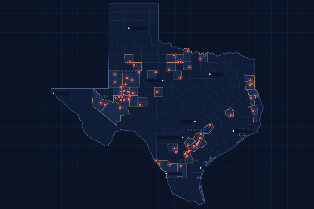
Counties and operators
Who drills, and where
Each county links to its Well Watch page, with its own map and every permit of the last two years. Each operator links to its page.
By county
- 1Midland County23
- 2Upton County17
- 3Live Oak County12
- 4Crane County10
- 5Gonzales County9
- 6Martin County8
- 7Webb County8
- 8De Witt County5
- 9Frio County5
- 10Andrews County4
- 11Archer County3
- 12Reeves County3
- 13Dawson County2
- 14Ector County2
- 15Fisher County2
And 26 more counties with fewer, in the list below.
By operator
- 1Pioneer Natural Res. USA, Inc.17
- 2Burlington Resources O & G Co LP13
- 3Diamondback E&P LLC11
- 4EOG Resources, Inc.11
- 5Blackbeard Operating, LLC10
- 6Chevron U. S. A. Inc.6
- 7Scout Energy Management LLC6
- 8Firebird Energy II LLC5
- 9Apache Corporation4
- 10Javelin Energy Partners Mgmt LLC4
- 11Vital Energy, Inc.4
- 12Fasken Oil and Ranch, Ltd.3
- 13SM Energy Company3
- 14Caturus Energy, LLC2
- 15Eagle Oil & Gas Co.2
And 35 more operators with fewer.
Register · July 7–13, 2025
Every permit, newest first
As the state files them: the lease and well, the operator, the kind of permit and the depth. “On the map” opens the county's live map at the well's spot.
Friday, July 1122 permits
- Andrews CountyFee 'Bp', well 512WBFasken Oil and Ranch, Ltd. · new drill · horizontal · 10,100 ftPermit 0909165 · API 42-003-49182On the map
- Andrews CountyFee 'Bp', well 510DNFasken Oil and Ranch, Ltd. · new drill · horizontal · 9,900 ftPermit 0909164 · API 42-003-49181On the map
- Andrews CountyFee 'Bp', well 508JMFasken Oil and Ranch, Ltd. · new drill · horizontal · 9,500 ftPermit 0909162 · API 42-003-49180On the map
- Baylor CountyWaggoner Ds-East Shallow, well 141DSWaggoner Operating, L.L.C. · recompletion · vertical · 4,634 ftPermit 0909128 · API 42-023-31765On the map
- Borden CountyBeavers B, well 1HIca Energy Operating, L.L.C. · new drill · horizontal · 8,500 ftPermit 0908926 · API 42-033-32786On the map
- Crane CountyWaddell Tr A, well 5402HBlackbeard Operating, LLC · new drill · horizontal · 7,999 ftPermit 0909137 · API 42-103-37650On the map
- Crane CountyWaddell Tr A, well 4520HBlackbeard Operating, LLC · new drill · horizontal · 7,999 ftPermit 0909115 · API 42-103-37649On the map
- Crane CountyWaddell Tr A, well 4664HBlackbeard Operating, LLC · new drill · horizontal · 7,999 ftPermit 0909114 · API 42-103-37648On the map
- De Witt CountySandy A-A. J. Baker A Sa 4, well 4HBPX Operating Company · new drill · horizontal · 14,000 ftPermit 0909157 · API 42-123-35629On the map
- De Witt CountyKlaevemann Unit A Usw, well 2Burlington Resources O & G Co LP · recompletion · horizontal · 12,748 ftPermit 0909149 · API 42-123-33668On the map
- De Witt CountyBarnhart Unit B, well 1Burlington Resources O & G Co LP · recompletion · horizontal · 12,045 ftPermit 0909139 · API 42-123-32797On the map
- Ector CountyHeadlee 29-20 N, well 1WADiamondback E&P LLC · new drill · horizontal · 12,500 ftPermit 0909176 · API 42-135-44126On the map
- Ector CountyHeadlee 29-20 L, well 2JMDiamondback E&P LLC · new drill · horizontal · 12,500 ftPermit 0909174 · API 42-135-44124On the map
- Frio CountyPendleton-Stx-Unit, well N735HFormentera Operations LLC · new drill · horizontal · 10,000 ftPermit 0909150 · API 42-163-34372On the map
- Live Oak CountyUSA Lark, well 3HSilver Hill Energy Operating LLC · new drill · horizontal · 11,400 ftPermit 0908216 · API 42-297-36509On the map
- Reeves CountyBlack Bear State H, well 13TBVital Energy, Inc. · new drill · horizontal · 10,500 ftPermit 0908576 · API 42-389-41805On the map
- Reeves CountyBlack Bear State A, well 9TBVital Energy, Inc. · new drill · horizontal · 10,500 ftPermit 0908557 · API 42-389-41804On the map
- Upton CountyElizabeth 1201 F, well 601HFirebird Energy II LLC · new drill · horizontal · 9,900 ftPermit 0909134 · API 42-461-43249On the map
- Upton CountyElizabeth 1201 C, well 301HFirebird Energy II LLC · new drill · horizontal · 9,000 ftPermit 0909133 · API 42-461-43248On the map
- Upton CountyElizabeth 1201 B, well 201HFirebird Energy II LLC · new drill · horizontal · 8,700 ftPermit 0909132 · API 42-461-43247On the map
- Upton CountyAllie 16, well 31MSSummit Petroleum LLC · new drill · horizontal · 7,600 ftPermit 0908774 · API 42-461-43228On the map
- Webb CountyBriscoe R (SA36), well 1609HSM Energy Company · new drill · horizontal · 8,000 ftPermit 0909125 · API 42-479-45414On the map
Thursday, July 1025 permits
- Archer CountyRichardson, Jt 'Abc', well 37AGuidance Oil Developers · new drill · vertical · 1,300 ftPermit 0909135 · API 42-009-43392On the map
- Archer CountyTurbeville B, well 1Eagle Oil & Gas Co. · new drill · vertical · 5,000 ftPermit 0909130 · API 42-009-43391On the map
- Crane CountyWaddell Tr A, well 4317HBlackbeard Operating, LLC · new drill · horizontal · 7,999 ftPermit 0909159 · API 42-103-37653On the map
- Crane CountyWaddell Tr A, well 4041HBlackbeard Operating, LLC · new drill · horizontal · 7,999 ftPermit 0909158 · API 42-103-37652On the map
- Crane CountyWaddell Tr A, well 4058HBlackbeard Operating, LLC · new drill · horizontal · 7,999 ftPermit 0909156 · API 42-103-37651On the map
- Crane CountyWaddell Tr A, well 4847HBlackbeard Operating, LLC · new drill · horizontal · 7,999 ftPermit 0909112 · API 42-103-37647On the map
- Crane CountyWaddell Tr A, well 4864HBlackbeard Operating, LLC · new drill · horizontal · 7,999 ftPermit 0909106 · API 42-103-37646On the map
- De Witt CountyWright Unit A, well 1Burlington Resources O & G Co LP · recompletion · horizontal · 12,782 ftPermit 0908907 · API 42-123-32752On the map
- Harrison CountyAlbert Key, well 1Buffco Production Inc. · reclass · vertical · 10,100 ftPermit 0909170 · API 42-203-34689On the map
- Martin CountyGreystoke 1-5 D, well 2WADiamondback E&P LLC · new drill · horizontal · 9,563 ftPermit 0909094 · API 42-317-46908On the map
- Martin CountyGreystoke 1-5 D, well 2JMDiamondback E&P LLC · new drill · horizontal · 9,563 ftPermit 0909093 · API 42-317-46906On the map
- Martin CountyGreystoke 1-5 C, well 1USDiamondback E&P LLC · new drill · horizontal · 9,563 ftPermit 0909091 · API 42-317-46903On the map
- Martin CountyGreystoke 1-5 C, well 2LSDiamondback E&P LLC · new drill · horizontal · 9,563 ftPermit 0909090 · API 42-317-46902On the map
- Martin CountyGreystoke 1-5 B, well 1WADiamondback E&P LLC · new drill · horizontal · 9,563 ftPermit 0909089 · API 42-317-46899On the map
- Martin CountyGreystoke 1-5 B, well 1JMDiamondback E&P LLC · new drill · horizontal · 9,563 ftPermit 0909082 · API 42-317-46898On the map
- Martin CountyGreystoke 1-5 A, well 1MSDiamondback E&P LLC · new drill · horizontal · 9,563 ftPermit 0909080 · API 42-317-46895On the map
- Martin CountyGreystoke 1-5 A, well 1LSDiamondback E&P LLC · new drill · horizontal · 9,563 ftPermit 0909079 · API 42-317-46894On the map
- Midland CountySlider D, well 4HBApache Corporation · new drill · horizontal · 12,000 ftPermit 0909119 · API 42-329-47869On the map
- Midland CountySlider C, well 3HBApache Corporation · new drill · horizontal · 12,000 ftPermit 0909118 · API 42-329-47868On the map
- Midland CountySlider B, well 2HBApache Corporation · new drill · horizontal · 12,000 ftPermit 0909116 · API 42-329-47867On the map
- Midland CountySlider A, well 1HBApache Corporation · new drill · horizontal · 12,000 ftPermit 0909113 · API 42-329-47866On the map
- Pecos CountyMillar, L. H.,etal '39', well 21Olsen Energy Inc. · recompletion · vertical · 3,900 ftPermit 0907326 · API 42-371-36270On the map
- Runnels CountyMocha Unit, well 1Pony Express Corporate Trust · recompletion · vertical · 4,740 ftPermit 0909136 · API 42-399-35458On the map
- Webb CountyBriscoe R (SA35) State, well 1598HSM Energy Company · new drill · horizontal · 8,000 ftPermit 0909123 · API 42-479-45413On the map
- Webb CountyBriscoe R (SA34) State, well 1599HSM Energy Company · new drill · horizontal · 8,000 ftPermit 0909122 · API 42-479-45412On the map
Wednesday, July 918 permits
- Crane CountyWaddell Tr A, well 4863HBlackbeard Operating, LLC · new drill · horizontal · 7,999 ftPermit 0909103 · API 42-103-37645On the map
- Crane CountyWaddell 13-25 8BN, well 5426HBlackbeard Operating, LLC · new drill · horizontal · 14,000 ftPermit 0909041 · API 42-103-37643On the map
- Glasscock CountySchwartz Q, well 7AVital Energy, Inc. · new drill · horizontal · 9,000 ftPermit 0908407 · API 42-173-39320On the map
- Glasscock CountySchwartz J, well 1AVital Energy, Inc. · new drill · horizontal · 9,000 ftPermit 0908406 · API 42-173-39319On the map
- Gonzales CountyFarrar, well 2LP Operating, LLC · new drill · vertical · 8,000 ftPermit 0908912 · API 42-177-34797On the map
- Howard CountyWright Msb 40-33 B, well 2MHSurge Operating, LLC · new drill · horizontal · 7,500 ftPermit 0908858 · API 42-227-42758On the map
- Howard CountyWright Msb 40-33 A, well 1MHSurge Operating, LLC · new drill · horizontal · 7,500 ftPermit 0908857 · API 42-227-42757On the map
- Jasper CountyOld Hickory Unit, well 1HIron Ridge Operating, LLC · new drill · horizontal · 15,000 ftPermit 0903070 · API 42-241-30929On the map
- Karnes CountyYanta North Unit 2, well 4Burlington Resources O & G Co LP · recompletion · horizontal · 12,345 ftPermit 0908986 · API 42-255-33656On the map
- Live Oak CountyPlomero Ranch, well 4Burlington Resources O & G Co LP · recompletion · horizontal · 12,002 ftPermit 0909026 · API 42-297-34905On the map
- Live Oak County1893 Oil & Gas, Ltd. Unit D, well 1Burlington Resources O & G Co LP · recompletion · horizontal · 12,650 ftPermit 0908911 · API 42-297-35107On the map
- Midland CountyHalogen G, well 103HDOxyrock Operating, LLC · recompletion · horizontal · 10,300 ftPermit 0902097 · API 42-329-44099On the map
- Midland CountyHalogen G, well 9BROxyrock Operating, LLC · recompletion · horizontal · 9,000 ftPermit 0902003 · API 42-329-44098On the map
- Panola CountyMullins, well 3Sheridan Production Co III, LLC · recompletion · vertical · 9,869 ftPermit 0909072 · API 42-365-32530On the map
- Reagan CountyShelby 34-22 H, well 4WADiamondback E&P LLC · new drill · horizontal · 8,726 ftPermit 0908187 · API 42-383-42100On the map
- Reeves CountyAgua Verde, well 1Direct Midstream LLC · new drill · vertical · 8,000 ftPermit 0909100 · API 42-389-41815On the map
- San Augustine CountyBrown-Weeks Alloc B, well 1HExco Operating Company, LP · new drill · horizontal · 15,500 ftPermit 0908958 · API 42-405-30878On the map
- Upton CountyBrook Unit O-1C, well 3HPioneer Natural Res. USA, Inc. · new drill · horizontal · 8,600 ftPermit 0908365 · API 42-461-43189On the map
Tuesday, July 851 permits
- De Witt CountyEdward Roeder-James Gano SA1, well 1HMarathon Oil Ef LLC · new drill · horizontal · 17,500 ftPermit 0908495 · API 42-123-35597On the map
- Frio CountyThunderbird 101HZ, well 101HZJavelin Energy Partners Mgmt LLC · new drill · horizontal · 9,000 ftPermit 0908864 · API 42-163-34371On the map
- Frio CountyThunderbird 101HY, well 101HYJavelin Energy Partners Mgmt LLC · new drill · horizontal · 9,000 ftPermit 0908863 · API 42-163-34370On the map
- Gaines CountySeminole San Andres Unit Swdd, well 6AOXY USA Inc. · new drill · vertical · 13,200 ftPermit 0909088 · API 42-165-39012On the map
- Gaines CountySeminole San Andres Unit Swdd, well 5AOXY USA Inc. · new drill · vertical · 13,200 ftPermit 0909086 · API 42-165-39011On the map
- Gonzales CountyRoosevelt H, well 8HEOG Resources, Inc. · new drill · horizontal · 11,500 ftPermit 0908506 · API 42-177-34796On the map
- Gonzales CountyRoosevelt G, well 7HEOG Resources, Inc. · new drill · horizontal · 11,500 ftPermit 0908505 · API 42-177-34795On the map
- Gonzales CountyRoosevelt F, well 6HEOG Resources, Inc. · new drill · horizontal · 11,500 ftPermit 0908504 · API 42-177-34794On the map
- Gonzales CountyRoosevelt E, well 5HEOG Resources, Inc. · new drill · horizontal · 11,500 ftPermit 0908503 · API 42-177-34793On the map
- Gonzales CountyRoosevelt D, well 4HEOG Resources, Inc. · new drill · horizontal · 11,500 ftPermit 0908502 · API 42-177-34792On the map
- Gonzales CountyRoosevelt C, well 3HEOG Resources, Inc. · new drill · horizontal · 11,500 ftPermit 0908501 · API 42-177-34791On the map
- Gonzales CountyRoosevelt B, well 2HEOG Resources, Inc. · new drill · horizontal · 11,500 ftPermit 0908500 · API 42-177-34790On the map
- Gonzales CountyRoosevelt A, well 1HEOG Resources, Inc. · new drill · horizontal · 11,500 ftPermit 0908499 · API 42-177-34789On the map
- Irion CountyMunson C, well U322HTriple Crown Resources, LLC · new drill · horizontal · 9,000 ftPermit 0909084 · API 42-235-36703On the map
- Irion CountyMunson C, well U321HTriple Crown Resources, LLC · new drill · horizontal · 9,000 ftPermit 0909083 · API 42-235-36702On the map
- Karnes CountyNichols Unit A, well 1Burlington Resources O & G Co LP · recompletion · horizontal · 12,642 ftPermit 0909045 · API 42-255-31863On the map
- Live Oak CountyPlomero Unit E, well 2Burlington Resources O & G Co LP · recompletion · horizontal · 11,923 ftPermit 0909033 · API 42-297-35664On the map
- Live Oak CountyPlomero Unit E, well 1Burlington Resources O & G Co LP · recompletion · horizontal · 11,910 ftPermit 0909032 · API 42-297-35665On the map
- Live Oak CountyThree Rivers Unit C, well 5HCaturus Energy, LLC · new drill · horizontal · 15,000 ftPermit 0909029 · API 42-297-36519On the map
- Live Oak CountyThree Rivers Unit C, well 4HCaturus Energy, LLC · new drill · horizontal · 15,000 ftPermit 0909027 · API 42-297-36518On the map
- Live Oak CountyOlson-Bk-Burgs A Usw B, well 1Burlington Resources O & G Co LP · new drill · horizontal · 17,500 ftPermit 0908972 · API 42-297-36516On the map
- Live Oak CountyOlson-Bk-Burgs A Ulw A, well 1Burlington Resources O & G Co LP · new drill · horizontal · 17,500 ftPermit 0908971 · API 42-297-36515On the map
- Live Oak CountyOlson-Bk-Burgs A Usw C, well 1Burlington Resources O & G Co LP · new drill · horizontal · 17,500 ftPermit 0908969 · API 42-297-36514On the map
- Live Oak CountyUSA Lark, well 2CHSilver Hill Energy Operating LLC · new drill · horizontal · 11,400 ftPermit 0908215 · API 42-297-36508On the map
- Midland CountyGbg Hercules 37-16 F, well 2096USChevron U. S. A. Inc. · new drill · horizontal · 10,500 ftPermit 0909040 · API 42-329-47865On the map
- Midland CountyGbg Hercules 37-16 E, well 2095USChevron U. S. A. Inc. · new drill · horizontal · 10,500 ftPermit 0909039 · API 42-329-47864On the map
- Midland CountyGbg Hercules 37-16 D, well 2094USChevron U. S. A. Inc. · new drill · horizontal · 10,500 ftPermit 0909038 · API 42-329-47863On the map
- Midland CountyGbg Hercules 37-16 C, well 2093USChevron U. S. A. Inc. · new drill · horizontal · 10,500 ftPermit 0909037 · API 42-329-47862On the map
- Midland CountyGbg Hercules 37-16 B, well 2092USChevron U. S. A. Inc. · new drill · horizontal · 10,500 ftPermit 0909036 · API 42-329-47861On the map
- Midland CountyGbg Hercules 37-16 A, well 2091USChevron U. S. A. Inc. · new drill · horizontal · 10,500 ftPermit 0909035 · API 42-329-47860On the map
- Midland CountySpoonbill-Donovan 10A, well 1HPioneer Natural Res. USA, Inc. · new drill · horizontal · 10,379 ftPermit 0908556 · API 42-329-47827On the map
- Midland CountySpoonbill-Donovan 10B, well 2HPioneer Natural Res. USA, Inc. · new drill · horizontal · 10,379 ftPermit 0908555 · API 42-329-47837On the map
- Midland CountySpoonbill-Donovan 10D, well 4HPioneer Natural Res. USA, Inc. · new drill · horizontal · 10,379 ftPermit 0908554 · API 42-329-47836On the map
- Midland CountySpoonbill-Donovan 10E, well 5HPioneer Natural Res. USA, Inc. · new drill · horizontal · 10,379 ftPermit 0908553 · API 42-329-47835On the map
- Midland CountySpoonbill-Donovan 10F, well 6HPioneer Natural Res. USA, Inc. · new drill · horizontal · 10,379 ftPermit 0908552 · API 42-329-47834On the map
- Midland CountySpoonbill-Donovan 10H, well 8HPioneer Natural Res. USA, Inc. · new drill · horizontal · 10,379 ftPermit 0908550 · API 42-329-47833On the map
- Midland CountySpoonbill-Donovan 10G, well 7HPioneer Natural Res. USA, Inc. · new drill · horizontal · 10,379 ftPermit 0908549 · API 42-329-47832On the map
- Midland CountySpoonbill-Donovan 10I, well 9HPioneer Natural Res. USA, Inc. · new drill · horizontal · 10,379 ftPermit 0908539 · API 42-329-47831On the map
- Midland CountySpoonbill-Donovan 10J, well 10HPioneer Natural Res. USA, Inc. · new drill · horizontal · 10,379 ftPermit 0908538 · API 42-329-47830On the map
- Midland CountySpoonbill-Donovan 10K, well 11HPioneer Natural Res. USA, Inc. · new drill · horizontal · 10,379 ftPermit 0908537 · API 42-329-47829On the map
- Midland CountySpoonbill-Donovan 10N, well 14HPioneer Natural Res. USA, Inc. · new drill · horizontal · 10,379 ftPermit 0908535 · API 42-329-47828On the map
- Panola CountyAllison Unit, well 2Sheridan Production Co III, LLC · recompletion · vertical · 9,614 ftPermit 0909101 · API 42-365-30824On the map
- Stephens CountyJackson Strawn Unit, well 714Caraway, Robert · recompletion · vertical · 2,090 ftPermit 0909071 · API 42-429-36349On the map
- Throckmorton CountyMatthews 23, well 8Subsea Operating Co. · new drill · vertical · 1,700 ftPermit 0909020 · API 42-447-36866On the map
- Throckmorton CountyMatthews 23, well 7Subsea Operating Co. · new drill · vertical · 1,700 ftPermit 0909017 · API 42-447-36865On the map
- Upton CountyElizabeth 1201 A, well 101HFirebird Energy II LLC · new drill · horizontal · 8,500 ftPermit 0908988 · API 42-461-43237On the map
- Upton CountyElizabeth 1201 D, well 202HFirebird Energy II LLC · new drill · horizontal · 8,500 ftPermit 0908976 · API 42-461-43235On the map
- Webb CountyMb - Wnh C, well 106HEOG Resources, Inc. · new drill · horizontal · 14,000 ftPermit 0909070 · API 42-479-45411On the map
- Webb CountyMb - Wnh B, well 105HEOG Resources, Inc. · new drill · horizontal · 14,000 ftPermit 0909069 · API 42-479-45410On the map
- Webb CountyMb - Wnh A, well 104HEOG Resources, Inc. · new drill · horizontal · 14,000 ftPermit 0909068 · API 42-479-45409On the map
- Wilson CountyOut of Your Element, well 3HWarwick-Artemis, LLC · new drill · horizontal · 8,900 ftPermit 0909021 · API 42-493-33019On the map
Monday, July 732 permits
- Andrews CountyUniversity 'P', well 6Scout Energy Management LLC · recompletion · vertical · 7,055 ftPermit 0908776 · API 42-003-38578On the map
- Archer CountyTurbeville, well 5Eagle Oil & Gas Co. · new drill · vertical · 5,000 ftPermit 0909062 · API 42-009-43389On the map
- Clay CountyKeeton, well 33Muirfield Exploration, Ltd. · new drill · vertical · 2,000 ftPermit 0909048 · API 42-077-35407On the map
- Cooke CountyVoth, H, well 14Felderhoff Production Company · new drill · vertical · 2,100 ftPermit 0909061 · API 42-097-34840On the map
- Dawson CountySterling B, well 2HHibernia Resources IV, LLC · new drill · horizontal · 9,500 ftPermit 0908472 · API 42-115-34079On the map
- Dawson CountySterling A, well 1HHibernia Resources IV, LLC · new drill · horizontal · 9,500 ftPermit 0908471 · API 42-115-34078On the map
- Duval CountyOrtiz, well 1South Texas Disposal Srvs, LLC · recompletion · vertical · 6,015 ftPermit 0903419 · API 42-131-39328On the map
- Fayette CountyAle Two, well H 02HAMagnolia Oil & Gas Operating LLC · new drill · horizontal · 11,000 ftPermit 0908941 · API 42-149-33621On the map
- Fisher CountyRice Bros. Canyon Unit, well 806Sojourner Drilling Corporation · new drill · vertical · 5,500 ftPermit 0909052 · API 42-151-33395On the map
- Fisher CountyRice Bros. (Canyon) Unit, well 805Sojourner Drilling Corporation · new drill · vertical · 5,500 ftPermit 0909050 · API 42-151-33394On the map
- Frio CountyThunderbird 101HX, well 101HXJavelin Energy Partners Mgmt LLC · new drill · horizontal · 9,000 ftPermit 0908862 · API 42-163-34369On the map
- Frio CountyThunderbird 101HW, well 101HWJavelin Energy Partners Mgmt LLC · new drill · horizontal · 9,000 ftPermit 0908861 · API 42-163-34368On the map
- Garza CountyRichardson Unit, well 11RCholla Petroleum, Inc. · new drill · vertical · 4,999 ftPermit 0909024 · API 42-169-34326On the map
- Jack CountyWorsham Steed Unit, well O 10Oakridge Oil and Gas, LP · new drill · vertical · 6,000 ftPermit 0909060 · API 42-237-40693On the map
- Jack CountyWorsham Steed Unit, well O 9Oakridge Oil and Gas, LP · new drill · vertical · 4,999 ftPermit 0909059 · API 42-237-40692On the map
- Live Oak CountyLaird Unit A, well 1Burlington Resources O & G Co LP · recompletion · horizontal · 11,799 ftPermit 0909044 · API 42-297-34926On the map
- Lubbock CountyUnion, well 1DRY Fork Production Co., LLC · new drill · vertical · 6,000 ftPermit 0909053 · API 42-303-31657On the map
- Shelby CountyNeilson Ranch B, well 1HPine Wave Energy Partners Op,llc · new drill · horizontal · 12,800 ftPermit 0908210 · API 42-419-31909On the map
- Upton CountyBrook A-2, well 11HPioneer Natural Res. USA, Inc. · new drill · horizontal · 10,495 ftPermit 0909067 · API 42-461-43246On the map
- Upton CountyBrook A-2, well 10HPioneer Natural Res. USA, Inc. · new drill · horizontal · 10,495 ftPermit 0909066 · API 42-461-43245On the map
- Upton CountyMcelroy, J. T., Cons., well 1971AScout Energy Management LLC · new drill · vertical · 3,090 ftPermit 0909065 · API 42-461-43244On the map
- Upton CountyMcelroy, J. T., Cons., well 1993AScout Energy Management LLC · new drill · vertical · 3,050 ftPermit 0909064 · API 42-461-43243On the map
- Upton CountyMcelroy, J. T., Cons., well 1992AScout Energy Management LLC · new drill · vertical · 3,050 ftPermit 0909063 · API 42-461-43242On the map
- Upton CountyMcelroy, J. T., Cons., well 1870AScout Energy Management LLC · new drill · vertical · 3,050 ftPermit 0909058 · API 42-461-43241On the map
- Upton CountyMcelroy, J. T., Cons., well 1970AScout Energy Management LLC · new drill · vertical · 3,090 ftPermit 0909057 · API 42-461-43240On the map
- Upton CountyBrook O-1G, well 7HPioneer Natural Res. USA, Inc. · new drill · horizontal · 10,922 ftPermit 0908364 · API 42-461-43188On the map
- Upton CountyBrook O-1F, well 6HPioneer Natural Res. USA, Inc. · new drill · horizontal · 10,922 ftPermit 0908363 · API 42-461-43187On the map
- Upton CountyBrook O-1B, well 2HPioneer Natural Res. USA, Inc. · new drill · horizontal · 10,922 ftPermit 0908362 · API 42-461-43186On the map
- Walker CountyMongoose, well 2Paleo Oil Company LLC · new drill · vertical · 3,700 ftPermit 0908469 · API 42-471-30411On the map
- Webb CountyFaith-State-Rincon 'E' Unit, well 4HStrand Energy, L.c. · new drill · horizontal · 4,000 ftPermit 0909049 · API 42-479-45408On the map
- Webb CountyFaith-State-Rincon 'E' Unit, well 3HStrand Energy, L.c. · new drill · horizontal · 4,000 ftPermit 0909047 · API 42-479-45407On the map
- Wilson CountyToe By 3 Oclock, well 4HWarwick-Artemis, LLC · new drill · horizontal · 8,900 ftPermit 0909022 · API 42-493-33020On the map
Cancelled permits are left out. To look a permit up at the source, use the Railroad Commission's drilling permit query with its permit number.
Archive
Earlier weeks
Each finished week, Monday to Sunday, has its own page that does not change. The feed gets one entry per week.
- Nov 9–15, 2026103
- Nov 2–8, 2026164
- Oct 26 – Nov 1, 2026242
- Oct 19–25, 2026215
- Oct 12–18, 2026147
- Oct 5–11, 2026166
- Sep 28 – Oct 4, 2026156
- Sep 21–27, 2026194
- Sep 14–20, 2026167
- Sep 7–13, 2026133
- Aug 31 – Sep 6, 2026182
- Aug 24–30, 2026118
Every week since January 1, 2024 (150 weeks)
2026
- Aug 17–23167
- Aug 10–16198
- Aug 3–9186
- Jul 27 – Aug 2143
- Jul 20–26170
- Jul 13–19117
- Jul 6–12194
- Jun 29 – Jul 5114
- Jun 22–28175
- Jun 15–21186
- Jun 8–14187
- Jun 1–7154
- May 25–31158
- May 18–24197
- May 11–17182
- May 4–10190
- Apr 27 – May 3156
- Apr 20–26210
- Apr 13–19133
- Apr 6–12206
- Mar 30 – Apr 5129
- Mar 23–29159
- Mar 16–22167
- Mar 9–15166
- Mar 2–8140
- Feb 23 – Mar 1181
- Feb 16–22141
- Feb 9–15133
- Feb 2–8124
- Jan 26 – Feb 1126
- Jan 19–25189
- Jan 12–18280
- Jan 5–11129
2025
- Dec 29 – Jan 4, 202656
- Dec 22–2846
- Dec 15–21154
- Dec 8–14119
- Dec 1–7128
- Nov 24–3061
- Nov 17–23140
- Nov 10–1698
- Nov 3–9107
- Oct 27 – Nov 2137
- Oct 20–26145
- Oct 13–19173
- Oct 6–12206
- Sep 29 – Oct 5124
- Sep 22–28141
- Sep 15–21165
- Sep 8–14127
- Sep 1–7105
- Aug 25–31145
- Aug 18–24115
- Aug 11–17140
- Aug 4–10131
- Jul 28 – Aug 3134
- Jul 21–27151
- Jul 14–20151
- Jul 7–13148
- Jun 30 – Jul 6148
- Jun 23–29167
- Jun 16–22118
- Jun 9–15115
- Jun 2–8147
- May 26 – Jun 190
- May 19–25148
- May 12–18120
- May 5–11114
- Apr 28 – May 4135
- Apr 21–27182
- Apr 14–20115
- Apr 7–13197
- Mar 31 – Apr 6194
- Mar 24–30170
- Mar 17–23189
- Mar 10–16177
- Mar 3–9141
- Feb 24 – Mar 2172
- Feb 17–23145
- Feb 10–16170
- Feb 3–9167
- Jan 27 – Feb 2149
- Jan 20–26158
- Jan 13–19176
- Jan 6–12140
2024
- Dec 30 – Jan 5, 202597
- Dec 23–295
- Dec 16–22168
- Dec 9–15202
- Dec 2–8182
- Nov 25 – Dec 189
- Nov 18–24189
- Nov 11–17145
- Nov 4–10152
- Oct 28 – Nov 3134
- Oct 21–27163
- Oct 14–20147
- Oct 7–13114
- Sep 30 – Oct 6138
- Sep 23–29133
- Sep 16–22175
- Sep 9–15144
- Sep 2–8138
- Aug 26 – Sep 1177
- Aug 19–25207
- Aug 12–18186
- Aug 5–11145
- Jul 29 – Aug 4191
- Jul 22–28174
- Jul 15–21164
- Jul 8–14205
- Jul 1–7106
- Jun 24–30183
- Jun 17–23192
- Jun 10–16161
- Jun 3–9176
- May 27 – Jun 2135
- May 20–26223
- May 13–19169
- May 6–12155
- Apr 29 – May 5191
- Apr 22–28224
- Apr 15–21200
- Apr 8–14157
- Apr 1–7149
- Mar 25–31102
- Mar 18–24130
- Mar 11–17228
- Mar 4–10178
- Feb 26 – Mar 3187
- Feb 19–25164
- Feb 12–18190
- Feb 5–11137
- Jan 29 – Feb 4177
- Jan 22–28172
- Jan 15–21107
- Jan 8–14251
- Jan 1–7148
FAQ
Questions people ask
What is a drilling permit?
Permission from the Railroad Commission of Texas to drill a well, or to re-enter or deepen an old one, at a stated spot and to a stated depth. An operator files for it before the rig comes; it lasts two years. Many permitted wells are drilled within months, some never are.
Is this week complete?
Yes. The state has issued permits on later days, so this week's list is closed. A permit the state cancels later drops off the list.
Some permits are not on the map. Why?
The map draws a permit at the well's surface location as the state files it. A new permit's location can take a few days to reach the state's files; until then it is listed here but not drawn.
Does a new permit near my land mean I will be paid?
No. A permit says where a well may be drilled, not whose minerals it will produce or who is paid. That depends on your lease, the unit the well is pooled in and the division order. If a well is drilled on or next to your tract, watch for a division order from the operator.
Can I get these by email or in a feed?
Yes. The feed on this page has one entry for each finished week, for any feed reader. For one county, an abstract or a lease, Texas Well Watch sends one email a week when the state files something new there; it is free with an account.
Sources
- Railroad Commission of Texas, drilling permit master and trailer, daily file (with latitudes and longitudes)www.rrc.texas.gov/resource-center/research/data-sets-available-for-download/ · loaded every night; newest permit on file November 19, 2026
- Railroad Commission of Texas, drilling permit query (one permit at the source)webapps.rrc.texas.gov/DP/initializePublicQueryAction.do · linked, not read
- US Census Bureau, cartographic boundary files (county lines), through the us-atlas package 3.0.1www.census.gov/geographies/mapping-files/time-series/geo/cartographic-boundary.html · built into the site with its well maps
- GeoNames, towns and their points (CC BY 4.0)www.geonames.org/ · built into the site with its town pages