
Railroad Commission of Texas · week of January 29, 2024
New Texas drilling permits, Jan 29 – Feb 4, 2024
- 177permits issued
- 141horizontal
- 46counties
- 57operators
That week
Where the state permitted wells
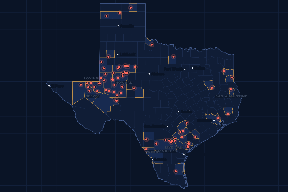
Counties and operators
Who drills, and where
Each county links to its Well Watch page, with its own map and every permit of the last two years. Each operator links to its page.
By county
- 1Loving County19
- 2Howard County15
- 3Reeves County15
- 4Reagan County12
- 5Upton County11
- 6Andrews County7
- 7De Witt County7
- 8Refugio County7
- 9Borden County6
- 10Live Oak County6
- 11McMullen County6
- 12Martin County5
- 13San Augustine County5
- 14Webb County5
- 15Gonzales County4
And 31 more counties with fewer, in the list below.
By operator
- 1BPX Operating Company17
- 2Civitas Permian Operating, LLC12
- 3Vital Energy, Inc.12
- 4EOG Resources, Inc.9
- 5Greenlake Energy Operating, LLC8
- 6Ovintiv USA Inc.7
- 7Anadarko E&P Onshore LLC6
- 8Aethon Energy Operating LLC5
- 9Burlington Resources O & G Co LP5
- 10Diamondback E&P LLC5
- 11Highpeak Energy Holdings, LLC5
- 12SM Energy Company5
- 13Baytex Energy USA, Inc.4
- 14Cog Operating LLC4
- 15King Operating Corporation4
And 42 more operators with fewer.
Register · January 29 – February 4, 2024
Every permit, newest first
As the state files them: the lease and well, the operator, the kind of permit and the depth. “On the map” opens the county's live map at the well's spot.
Friday, February 242 permits
- Bee CountyRtc, well 2Paleo Oil Company LLC · new drill · vertical · 6,500 ftPermit 0884043 · API 42-025-34025On the map
- Borden CountyMiller Ranch, well C305King Operating Corporation · new drill · vertical · 9,000 ftPermit 0896803 · API 42-033-32680On the map
- Borden CountyMiller Ranch, well G306King Operating Corporation · new drill · vertical · 9,000 ftPermit 0896749 · API 42-033-32679On the map
- De Witt CountyWilleke A, well 20HBPX Operating Company · new drill · horizontal · 14,000 ftPermit 0896978 · API 42-123-35370On the map
- De Witt CountyWilleke A, well 19HBPX Operating Company · new drill · horizontal · 14,000 ftPermit 0896977 · API 42-123-35371On the map
- De Witt CountyWilleke A, well 18HBPX Operating Company · new drill · horizontal · 14,000 ftPermit 0896976 · API 42-123-35369On the map
- De Witt CountyWilleke A, well 17HBPX Operating Company · new drill · horizontal · 14,000 ftPermit 0896974 · API 42-123-35368On the map
- De Witt CountyBlackwell A-Oehlke A Sa 3, well 3HBPX Operating Company · new drill · horizontal · 14,000 ftPermit 0896860 · API 42-123-35367On the map
- De Witt CountyBlackwell A-Oehlke A Sa 2, well 2HBPX Operating Company · new drill · horizontal · 14,000 ftPermit 0896859 · API 42-123-35366On the map
- Ector CountyR.b. Cowden 'B', well 17Fivestones Energy LLC · recompletion · vertical · 7,970 ftPermit 0896997 · API 42-135-21198On the map
- Glasscock CountyDaniel 11-2 F, well 4WADiamondback E&P LLC · new drill · horizontal · 8,137 ftPermit 0896770 · API 42-173-39091On the map
- Glasscock CountyDaniel 11-2 E, well 3WADiamondback E&P LLC · new drill · horizontal · 8,137 ftPermit 0896768 · API 42-173-39090On the map
- Goliad CountyWeise, Fritz, well 9United Texas Oil LLC · recompletion · vertical · 15,500 ftPermit 0896927 · API 42-175-34033On the map
- Hardeman CountyMcclellan, well 2Trio Consulting & Management,llc · new drill · vertical · 8,300 ftPermit 0896799 · API 42-197-31810On the map
- Harrison CountyCrawford, A., well 1Buffco Production Inc. · recompletion · vertical · 10,995 ftPermit 0896827 · API 42-203-32853On the map
- Hartley CountyThompson E, well 4DDD Exploration, Inc. · new drill · vertical · 6,500 ftPermit 0897031 · API 42-205-30422On the map
- Howard CountyCareless Whisper K 19-15, well 6SHSurge Operating, LLC · new drill · horizontal · 8,000 ftPermit 0896925 · API 42-227-42388On the map
- Howard CountyCareless Whisper L 19-15, well 6AHSurge Operating, LLC · new drill · horizontal · 8,000 ftPermit 0896924 · API 42-227-42387On the map
- Howard CountyBow Tie F, well 8MSVital Energy, Inc. · new drill · horizontal · 9,000 ftPermit 0896921 · API 42-227-42397On the map
- Howard CountyMr. Dynamite C, well 5MSVital Energy, Inc. · new drill · horizontal · 9,000 ftPermit 0896746 · API 42-227-42385On the map
- Howard CountyMr. Dynamite A, well 3MSVital Energy, Inc. · new drill · horizontal · 9,000 ftPermit 0896745 · API 42-227-42379On the map
- Howard CountyMr. Dynamite 41-44, well 7DNVital Energy, Inc. · new drill · horizontal · 9,000 ftPermit 0896739 · API 42-227-42378On the map
- Kenedy CountySanta Fe Julian Pasture, well 1Abaco Operating, LLC · recompletion · vertical · 9,200 ftPermit 0896999 · API 42-261-31510On the map
- La Salle CountyBenet Mercie B, well 2HEp Energy E&P Company, LLC · new drill · horizontal · 8,375 ftPermit 0896793 · API 42-283-37595On the map
- Live Oak CountyDobie Ranch, well 10Burlington Resources O & G Co LP · new drill · horizontal · 17,500 ftPermit 0896926 · API 42-297-36407On the map
- Loving CountyUl 19 Stonefly M, well 1571HPDEH LLC · new drill · horizontal · 12,700 ftPermit 0896980 · API 42-301-36758On the map
- Loving CountyUl 19 Stonefly H, well 1552HPDEH LLC · new drill · horizontal · 10,200 ftPermit 0896971 · API 42-301-36755On the map
- Loving CountyUl 19 Stonefly G, well 1551HPDEH LLC · new drill · horizontal · 10,100 ftPermit 0896970 · API 42-301-36754On the map
- Martin CountyCorretto 97-9 A, well 1JMDiamondback E&P LLC · new drill · horizontal · 13,000 ftPermit 0896796 · API 42-317-45852On the map
- Midland CountyRio San Gabriel 28-29 Unit 1, well 145Endeavor Energy Resources L.P. · new drill · horizontal · 10,328 ftPermit 0896875 · API 42-329-46788On the map
- Midland CountyRio San Gabriel 28-29 Unit 1, well 133Endeavor Energy Resources L.P. · new drill · horizontal · 10,328 ftPermit 0896873 · API 42-329-46787On the map
- Midland CountyRio San Gabriel 28-29 Unit 1, well 123Endeavor Energy Resources L.P. · new drill · horizontal · 10,328 ftPermit 0896871 · API 42-329-46784On the map
- Moore CountyBain, well 1J. W. Resources Inc. · new drill · vertical · 6,000 ftPermit 0897000 · API 42-341-33763On the map
- Panola CountyVentana SWD, well 1Ventana Midstream LLC · new drill · vertical · 8,300 ftPermit 0897006 · API 42-365-38898On the map
- Pecos CountyYates Field Unit, well 37A44Kinder Morgan Production Co LLC · recompletion · horizontal · 1,999 ftPermit 0897018 · API 42-371-33602On the map
- Pecos CountyYates Field Unit, well 25A20Kinder Morgan Production Co LLC · recompletion · horizontal · 1,999 ftPermit 0897011 · API 42-371-34730On the map
- Refugio CountyGrape Mott Strat, well 1Conocophillips Texas Gulf Coast · new drill · vertical · 9,500 ftPermit 0897017 · API 42-391-33327On the map
- Refugio CountyMocha Strat, well 1Conocophillips Texas Gulf Coast · new drill · vertical · 9,500 ftPermit 0897016 · API 42-391-33326On the map
- Refugio CountyO'Connor -D-, well D 48T-C Oil Company, LLC · new drill · vertical · 5,000 ftPermit 0896983 · API 42-391-33325On the map
- Scurry CountyJones SWD, well 1Petroplex SWD System, LLC · new drill · vertical · 9,000 ftPermit 0897014 · API 42-415-35749On the map
- Scurry CountyHorse Hollow, well 1HCanan Mowrey Operating, LLC · new drill · horizontal · 7,500 ftPermit 0896825 · API 42-415-35750On the map
- Zavala CountyFerguson-Mcknight, well H 02WTMagnolia Oil & Gas Operating LLC · new drill · horizontal · 8,500 ftPermit 0896852 · API 42-507-33530On the map
Thursday, February 127 permits
- De Witt CountyKickendahl Unit 1-OEHLKE A Sa 1, well 1HBPX Operating Company · new drill · horizontal · 14,000 ftPermit 0896858 · API 42-123-35365On the map
- Gonzales CountyTerra D, well 4HBaytex Energy USA, Inc. · new drill · horizontal · 14,500 ftPermit 0896919 · API 42-177-34683On the map
- Gonzales CountyTerra C, well 3HBaytex Energy USA, Inc. · new drill · horizontal · 14,500 ftPermit 0896918 · API 42-177-34682On the map
- Gonzales CountyTerra B, well 2HBaytex Energy USA, Inc. · new drill · horizontal · 14,500 ftPermit 0896917 · API 42-177-34681On the map
- Gonzales CountyTerra A, well 1HBaytex Energy USA, Inc. · new drill · horizontal · 14,500 ftPermit 0896916 · API 42-177-34680On the map
- Howard CountySequoia 13DD, well 4HGOvintiv USA Inc. · new drill · horizontal · 9,800 ftPermit 0896111 · API 42-227-42360On the map
- Howard CountySequoia 13E, well 3HFOvintiv USA Inc. · new drill · horizontal · 9,800 ftPermit 0896110 · API 42-227-42359On the map
- Howard CountySequoia 13D, well 2HKOvintiv USA Inc. · new drill · horizontal · 9,800 ftPermit 0896103 · API 42-227-42358On the map
- Howard CountySequoia 13C, well 1HFOvintiv USA Inc. · new drill · horizontal · 9,800 ftPermit 0896102 · API 42-227-42357On the map
- La Salle CountyBenet Mercie A, well 1HEp Energy E&P Company, LLC · new drill · horizontal · 8,375 ftPermit 0896849 · API 42-283-37596On the map
- Live Oak County1893 G-H Usw K, well 1Burlington Resources O & G Co LP · new drill · horizontal · 17,500 ftPermit 0896936 · API 42-297-36411On the map
- Live Oak County1893 G-H Usw J, well 1Burlington Resources O & G Co LP · new drill · horizontal · 17,500 ftPermit 0896934 · API 42-297-36410On the map
- Live Oak County1893 G-H Usw F, well 1Burlington Resources O & G Co LP · new drill · horizontal · 17,500 ftPermit 0896932 · API 42-297-36409On the map
- Live Oak County1893 Oil & Gas, Ltd. Unit G, well 2Burlington Resources O & G Co LP · new drill · horizontal · 17,500 ftPermit 0896931 · API 42-297-36408On the map
- Live Oak CountySinor Wilcox Unit, well 208Merit Energy Company · new drill · vertical · 8,450 ftPermit 0896759 · API 42-297-36405On the map
- Loving CountyHat Trick 56-T1-42X31 Bg, well W207HBPX Operating Company · new drill · horizontal · 12,295 ftPermit 0896947 · API 42-301-36753On the map
- Loving CountyHat Trick 56-T1-42X31 Yd, well X104HBPX Operating Company · new drill · horizontal · 12,295 ftPermit 0896944 · API 42-301-36752On the map
- Martin CountyCorretto 98-8 H, well 2USDiamondback E&P LLC · new drill · horizontal · 13,000 ftPermit 0896614 · API 42-317-45853On the map
- Reeves CountySoda Popinski 27, well 3HGreenlake Energy Operating, LLC · new drill · horizontal · 11,000 ftPermit 0896955 · API 42-389-41056On the map
- Refugio CountyT-C Oil Co. - O'Connor, well 128T-C Oil Company, LLC · new drill · vertical · 5,000 ftPermit 0896928 · API 42-391-33322On the map
- San Augustine CountyChipper-Sally Ride-S. Timber A, well 5HAethon Energy Operating LLC · new drill · horizontal · 13,500 ftPermit 0896996 · API 42-405-30836On the map
- San Augustine CountyChipper - Sally Ride B, well 4HAethon Energy Operating LLC · new drill · horizontal · 13,500 ftPermit 0896995 · API 42-405-30835On the map
- San Augustine CountyChipper - Sally Ride A, well 3HAethon Energy Operating LLC · new drill · horizontal · 13,500 ftPermit 0896994 · API 42-405-30834On the map
- San Augustine CountyChipper, well 2HAethon Energy Operating LLC · new drill · horizontal · 13,500 ftPermit 0896993 · API 42-405-30833On the map
- San Augustine CountyChipper, well 1HAethon Energy Operating LLC · new drill · horizontal · 13,500 ftPermit 0896992 · API 42-405-30832On the map
- Yoakum CountyHigginbotham A, well 9HBurk Royalty Co., Ltd. · new drill · horizontal · 5,500 ftPermit 0896940 · API 42-501-37518On the map
- Yoakum CountyHigginbotham A, well 8HBurk Royalty Co., Ltd. · new drill · horizontal · 5,500 ftPermit 0896939 · API 42-501-37517On the map
Wednesday, January 3149 permits
- Anderson CountyTemple Inland, well 20RJla Resources Company · new drill · vertical · 2,000 ftPermit 0896851 · API 42-001-32848On the map
- Borden CountyPixie Unit A 35-47, well 3SHSurge Operating, LLC · new drill · horizontal · 8,500 ftPermit 0896830 · API 42-033-32682On the map
- Borden CountyPixie Unit A 35-47, well 3AHSurge Operating, LLC · new drill · horizontal · 8,500 ftPermit 0896826 · API 42-033-32681On the map
- Crane CountyBlock 31 Unit, well F 5FOXY USA Inc. · recompletion · vertical · 7,500 ftPermit 0895686 · API 42-103-32080On the map
- Hardin CountyLynn Oil Company, well 12Radco Operations, L.P. · re-entry · vertical · 4,025 ftPermit 0895407 · API 42-199-30037On the map
- Hockley CountySlaughter, Bob, well 621Sabinal Energy Operating, LLC · new drill · vertical · 9,000 ftPermit 0896804 · API 42-219-37529On the map
- Jack CountyPowers, well 1SB.o.l.d. Oil and Gas, LLC · new drill · vertical · 3,500 ftPermit 0896817 · API 42-237-40652On the map
- Loving CountyHat Trick 56-T1-42X31 Ya, well X101HBPX Operating Company · new drill · horizontal · 12,260 ftPermit 0896910 · API 42-301-36745On the map
- Loving CountyTitan, well 556HEOG Resources, Inc. · new drill · horizontal · 12,000 ftPermit 0896909 · API 42-301-36751On the map
- Loving CountyTitan, well 555HEOG Resources, Inc. · new drill · horizontal · 12,000 ftPermit 0896908 · API 42-301-36750On the map
- Loving CountyTitan, well 554HEOG Resources, Inc. · new drill · horizontal · 12,000 ftPermit 0896907 · API 42-301-36749On the map
- Loving CountyHat Trick 56-T1-42X31 Bh, well W208HBPX Operating Company · new drill · horizontal · 12,295 ftPermit 0896906 · API 42-301-36744On the map
- Loving CountyTitan, well 553HEOG Resources, Inc. · new drill · horizontal · 12,000 ftPermit 0896905 · API 42-301-36748On the map
- Loving CountyTitan, well 552HEOG Resources, Inc. · new drill · horizontal · 12,000 ftPermit 0896904 · API 42-301-36747On the map
- Loving CountyTitan, well 551HEOG Resources, Inc. · new drill · horizontal · 12,000 ftPermit 0896903 · API 42-301-36746On the map
- Martin CountyRio 27-15 Y, well 25MSDiamondback E&P LLC · new drill · horizontal · 10,250 ftPermit 0896252 · API 42-317-45821On the map
- Martin CountyEasy Target 3095OP, well 3HOccidental Permian Ltd. · new drill · horizontal · 13,000 ftPermit 0896209 · API 42-317-45817On the map
- Martin CountyEasy Target 1993OP, well 2HOccidental Permian Ltd. · new drill · horizontal · 13,000 ftPermit 0896208 · API 42-317-45816On the map
- McMullen CountyJambers, well 119HMurphy Expl. & Prod. Co. - USA · new drill · horizontal · 13,000 ftPermit 0896945 · API 42-311-37463On the map
- McMullen CountyJambers, well 29HMurphy Expl. & Prod. Co. - USA · new drill · horizontal · 13,000 ftPermit 0896943 · API 42-311-37462On the map
- McMullen CountyJambers, well 28HMurphy Expl. & Prod. Co. - USA · new drill · horizontal · 13,000 ftPermit 0896941 · API 42-311-37461On the map
- McMullen CountyLocke Partnership G, well 7HGulftex Energy, LLC · new drill · horizontal · 10,000 ftPermit 0896534 · API 42-311-37456On the map
- Reeves CountySoda Popinski 27, well 6HGreenlake Energy Operating, LLC · new drill · horizontal · 11,000 ftPermit 0896958 · API 42-389-41059On the map
- Reeves CountySoda Popinski 27, well 5HGreenlake Energy Operating, LLC · new drill · horizontal · 11,000 ftPermit 0896957 · API 42-389-41058On the map
- Reeves CountySoda Popinski 27, well 4HGreenlake Energy Operating, LLC · new drill · horizontal · 11,000 ftPermit 0896956 · API 42-389-41057On the map
- Reeves CountySoda Popinski 27, well 2HGreenlake Energy Operating, LLC · new drill · horizontal · 11,000 ftPermit 0896954 · API 42-389-41055On the map
- Reeves CountySoda Popinski 27, well 1HGreenlake Energy Operating, LLC · new drill · horizontal · 11,000 ftPermit 0896953 · API 42-389-41054On the map
- Reeves CountyLa Cucaracha State Unit, well 711HEOG Resources, Inc. · new drill · horizontal · 14,000 ftPermit 0896846 · API 42-389-41060On the map
- Reeves CountyThreadfin 57-1-47-35 H, well 74HAnadarko E&P Onshore LLC · new drill · horizontal · 13,000 ftPermit 0896845 · API 42-389-41047On the map
- Reeves CountyThreadfin 57-1-47-35 E, well 73HAnadarko E&P Onshore LLC · new drill · horizontal · 13,000 ftPermit 0896844 · API 42-389-41046On the map
- Reeves CountyThreadfin 57-1-47-35 C, well 72HAnadarko E&P Onshore LLC · new drill · horizontal · 13,000 ftPermit 0896843 · API 42-389-41045On the map
- Reeves CountyThreadfin 57-1-47-35 G, well 64HAnadarko E&P Onshore LLC · new drill · horizontal · 13,000 ftPermit 0896816 · API 42-389-41044On the map
- Reeves CountyThreadfin 57-1-47-35 F, well 63HAnadarko E&P Onshore LLC · new drill · horizontal · 13,000 ftPermit 0896815 · API 42-389-41043On the map
- Reeves CountyThreadfin 57-1-47-35 D, well 62HAnadarko E&P Onshore LLC · new drill · horizontal · 13,000 ftPermit 0896813 · API 42-389-41040On the map
- Refugio CountyT-C Oil Co. - O'Connor, well 130T-C Oil Company, LLC · new drill · vertical · 5,000 ftPermit 0896930 · API 42-391-33324On the map
- Refugio CountyT-C Oil Co. - O'Connor, well 129T-C Oil Company, LLC · new drill · vertical · 5,000 ftPermit 0896929 · API 42-391-33323On the map
- Refugio CountyWilliams, Maude Etal -A-, well D 4Hilcorp Energy Company · recompletion · vertical · 5,766 ftPermit 0896855 · API 42-391-00271On the map
- Upton CountyBig Tree West D, well 9AVital Energy, Inc. · new drill · horizontal · 9,000 ftPermit 0896788 · API 42-461-42709On the map
- Upton CountyBig Tree West G, well 7LSVital Energy, Inc. · new drill · horizontal · 9,000 ftPermit 0896787 · API 42-461-42708On the map
- Upton CountyBig Tree West F, well 6AVital Energy, Inc. · new drill · horizontal · 9,000 ftPermit 0896785 · API 42-461-42706On the map
- Upton CountyBig Tree West C, well 5AVital Energy, Inc. · new drill · horizontal · 9,000 ftPermit 0896784 · API 42-461-42705On the map
- Upton CountyBig Tree West E, well 3LSVital Energy, Inc. · new drill · horizontal · 9,000 ftPermit 0896767 · API 42-461-42704On the map
- Upton CountyBig Tree West B, well 4BVital Energy, Inc. · new drill · horizontal · 9,000 ftPermit 0896764 · API 42-461-42703On the map
- Upton CountyBig Tree West A, well 2HVital Energy, Inc. · new drill · horizontal · 10,900 ftPermit 0896744 · API 42-461-42702On the map
- Upton CountyHerbert 102C, well 3HGOvintiv USA Inc. · new drill · horizontal · 10,300 ftPermit 0896589 · API 42-461-42700On the map
- Upton CountyHerbert 102A, well 2HDOvintiv USA Inc. · new drill · horizontal · 10,300 ftPermit 0896588 · API 42-461-42699On the map
- Upton CountyHerbert 102A, well 1HLOvintiv USA Inc. · new drill · horizontal · 10,300 ftPermit 0896586 · API 42-461-42698On the map
- Winkler CountyState-Walton, well 1401Basin Oil & Gas Operating, LLC · new drill · vertical · 5,900 ftPermit 0896893 · API 42-495-34954On the map
- Winkler CountyBaird, W. E., well 1254Basin Oil & Gas Operating, LLC · new drill · vertical · 7,800 ftPermit 0896682 · API 42-495-34949On the map
Tuesday, January 3025 permits
- Andrews CountyCross Bar Ranch, well 1704LHCog Operating LLC · new drill · horizontal · 12,000 ftPermit 0896880 · API 42-003-48905On the map
- Andrews CountyCross Bar Ranch, well 1703AHCog Operating LLC · new drill · horizontal · 12,000 ftPermit 0896879 · API 42-003-48903On the map
- Andrews CountyCross Bar Ranch, well 1702LHCog Operating LLC · new drill · horizontal · 12,000 ftPermit 0896877 · API 42-003-48902On the map
- Andrews CountyCross Bar Ranch, well 1702JHCog Operating LLC · new drill · horizontal · 12,000 ftPermit 0896874 · API 42-003-48901On the map
- Andrews CountyBullhead 10, well 2NGL Water Solutions Permian, LLC · new drill · vertical · 6,300 ftPermit 0896865 · API 42-003-48904On the map
- Andrews CountyBullhead 10, well 1NGL Water Solutions Permian, LLC · new drill · vertical · 6,300 ftPermit 0896864 · API 42-003-48900On the map
- Dawson CountyLioness, well 1Seaboard Operating Co. · re-entry · vertical · 7,100 ftPermit 0896899 · API 42-115-33720On the map
- Dawson CountyPatricia 4, well 2Abaco Operating, LLC · new drill · vertical · 8,500 ftPermit 0896828 · API 42-115-33963On the map
- Howard CountyCarpenter 11-31 B Unit, well L 5HHighpeak Energy Holdings, LLC · new drill · horizontal · 6,100 ftPermit 0896842 · API 42-227-42383On the map
- Jackson CountyWest Ranch (41-A/98-A Cons) Unit, well 1069Hilcorp Energy Company · reclass · vertical · 6,438 ftPermit 0896854 · API 42-239-33707On the map
- Karnes CountyOlson Esse-Kennedy SA1, well 1HMarathon Oil Ef LLC · new drill · horizontal · 24,000 ftPermit 0896041 · API 42-255-37927On the map
- Karnes CountyOlson Esse-Kennedy SA2, well 2HMarathon Oil Ef LLC · new drill · horizontal · 22,000 ftPermit 0896040 · API 42-255-37926On the map
- Loving CountyHat Trick 56-T1-42X31 Bb, well W202HBPX Operating Company · new drill · horizontal · 12,260 ftPermit 0896902 · API 42-301-36743On the map
- Loving CountyHat Trick 56-T1-42X31 Ba, well W201HBPX Operating Company · new drill · horizontal · 12,260 ftPermit 0896901 · API 42-301-36742On the map
- Loving CountyHat Trick 56-T1-42X31 H, well W108HBPX Operating Company · new drill · horizontal · 12,295 ftPermit 0896900 · API 42-301-36741On the map
- Loving CountyHat Trick 56-T1-42X31 G, well W107HBPX Operating Company · new drill · horizontal · 12,295 ftPermit 0896861 · API 42-301-36740On the map
- Loving CountyHat Trick 56-T1-42X31 B, well W102HBPX Operating Company · new drill · horizontal · 12,260 ftPermit 0896857 · API 42-301-36739On the map
- Loving CountyHat Trick 56-T1-42X31 A, well W101HBPX Operating Company · new drill · horizontal · 12,260 ftPermit 0896856 · API 42-301-36738On the map
- Ochiltree CountyBozeman, well 1Texakoma E & P, LLC · new drill · vertical · 8,500 ftPermit 0896853 · API 42-357-33763On the map
- Pecos CountyYates Field Unit, well 37D50Kinder Morgan Production Co LLC · recompletion · horizontal · 1,999 ftPermit 0896870 · API 42-371-33848On the map
- Reeves CountyLa Cucaracha State Unit, well 733HEOG Resources, Inc. · new drill · horizontal · 14,000 ftPermit 0896848 · API 42-389-41049On the map
- Reeves CountyLa Cucaracha State Unit, well 732HEOG Resources, Inc. · new drill · horizontal · 14,000 ftPermit 0896847 · API 42-389-41048On the map
- Scurry CountyWest Fork, well 1Discovery Operating, Inc. · new drill · horizontal · 8,400 ftPermit 0896406 · API 42-415-35747On the map
- Tom Green CountyJje, well 1WDMoriah Operating,llc · new drill · vertical · 4,500 ftPermit 0896872 · API 42-451-32916On the map
- Upton CountyBig Tree West D, well 8BVital Energy, Inc. · new drill · horizontal · 9,000 ftPermit 0896786 · API 42-461-42707On the map
Monday, January 2934 permits
- Andrews CountyUniversity Block 14 Cons., well 2406HRing Energy, Inc. · new drill · horizontal · 5,600 ftPermit 0896384 · API 42-003-48075On the map
- Borden CountyMiller Ranch 8500, well D528HKing Operating Corporation · new drill · horizontal · 9,000 ftPermit 0896765 · API 42-033-32684On the map
- Borden CountyMiller Ranch 8500, well F475HKing Operating Corporation · new drill · horizontal · 9,000 ftPermit 0896757 · API 42-033-32683On the map
- Crane CountyWaddell Tr A, well 4663HBlackbeard Operating, LLC · new drill · horizontal · 7,999 ftPermit 0896112 · API 42-103-37420On the map
- Culberson CountyTaylor Ranch State Unit, well 0056TBChevron U. S. A. Inc. · new drill · horizontal · 10,000 ftPermit 0896569 · API 42-109-34195On the map
- Culberson CountyTaylor Ranch State Unit, well 0054TBChevron U. S. A. Inc. · new drill · horizontal · 10,000 ftPermit 0896568 · API 42-109-34194On the map
- Culberson CountyTaylor Ranch State Unit, well 0052TBChevron U. S. A. Inc. · new drill · horizontal · 10,000 ftPermit 0896567 · API 42-109-34193On the map
- Gaines CountyWest Seminole Sand Unit, well 715OXY USA WTP LP · recompletion · vertical · 5,600 ftPermit 0896794 · API 42-165-32406On the map
- Harris CountySusan B. Michalsky Et Al, well 1Castex Energy, Inc. · new drill · vertical · 11,700 ftPermit 0894707 · API 42-201-33006On the map
- Howard CountyCarpenter 11-31 B Unit, well A 5HHighpeak Energy Holdings, LLC · new drill · horizontal · 6,400 ftPermit 0896841 · API 42-227-42382On the map
- Howard CountyCarpenter 11-31 A Unit, well L 3HHighpeak Energy Holdings, LLC · new drill · horizontal · 6,150 ftPermit 0896840 · API 42-227-42381On the map
- Howard CountyValencia 10-8 A Unit, well A 1HHighpeak Energy Holdings, LLC · new drill · horizontal · 6,300 ftPermit 0896839 · API 42-227-42380On the map
- Howard CountyJudith 67-5 A Unit, well A 3HHighpeak Energy Holdings, LLC · new drill · horizontal · 6,200 ftPermit 0896766 · API 42-227-42386On the map
- McMullen CountyLocke Partnership F, well 6HGulftex Energy, LLC · new drill · horizontal · 10,000 ftPermit 0896533 · API 42-311-37455On the map
- McMullen CountyLocke Partnership E, well 5HGulftex Energy, LLC · new drill · horizontal · 10,000 ftPermit 0896521 · API 42-311-37454On the map
- Reagan CountyHolly Ee, well 32HCivitas Permian Operating, LLC · new drill · horizontal · 11,000 ftPermit 0896120 · API 42-383-41660On the map
- Reagan CountyHolly Ee, well 31HCivitas Permian Operating, LLC · new drill · horizontal · 11,000 ftPermit 0896119 · API 42-383-41659On the map
- Reagan CountyHolly Dd, well 30HCivitas Permian Operating, LLC · new drill · horizontal · 8,423 ftPermit 0896118 · API 42-383-41658On the map
- Reagan CountyHolly Cc, well 29HCivitas Permian Operating, LLC · new drill · horizontal · 10,150 ftPermit 0896117 · API 42-383-41657On the map
- Reagan CountyHolly Aa, well 28HCivitas Permian Operating, LLC · new drill · horizontal · 8,761 ftPermit 0896116 · API 42-383-41656On the map
- Reagan CountyHolly Aa, well 27HCivitas Permian Operating, LLC · new drill · horizontal · 8,075 ftPermit 0896115 · API 42-383-41655On the map
- Reagan CountyHolly Z, well 26HCivitas Permian Operating, LLC · new drill · horizontal · 11,000 ftPermit 0896114 · API 42-383-41654On the map
- Reagan CountyHolly S, well 20HCivitas Permian Operating, LLC · new drill · horizontal · 11,000 ftPermit 0896002 · API 42-383-41642On the map
- Reagan CountyHolly S, well 19HCivitas Permian Operating, LLC · new drill · horizontal · 11,000 ftPermit 0895998 · API 42-383-41641On the map
- Reagan CountyHolly R, well 18HCivitas Permian Operating, LLC · new drill · horizontal · 11,000 ftPermit 0895997 · API 42-383-41640On the map
- Reagan CountyHolly Q, well 17HCivitas Permian Operating, LLC · new drill · horizontal · 11,000 ftPermit 0895996 · API 42-383-41639On the map
- Reagan CountyHolly O, well 15HCivitas Permian Operating, LLC · new drill · horizontal · 11,000 ftPermit 0895951 · API 42-383-41635On the map
- Ward CountyCarajillo 25, well 2HGreenlake Energy Operating, LLC · new drill · horizontal · 11,700 ftPermit 0896790 · API 42-475-38747On the map
- Ward CountyCarajillo 25, well 1HGreenlake Energy Operating, LLC · new drill · horizontal · 11,700 ftPermit 0896789 · API 42-475-38746On the map
- Webb CountyBriscoe G, well 773HSM Energy Company · new drill · horizontal · 8,000 ftPermit 0896775 · API 42-479-45102On the map
- Webb CountyBriscoe B (SA23), well 1419HSM Energy Company · new drill · horizontal · 8,000 ftPermit 0896774 · API 42-479-45101On the map
- Webb CountyBriscoe B (SA22), well 1408HSM Energy Company · new drill · horizontal · 8,000 ftPermit 0896773 · API 42-479-45100On the map
- Webb CountyBriscoe B (SA21), well 1399HSM Energy Company · new drill · horizontal · 8,000 ftPermit 0896771 · API 42-479-45099On the map
- Webb CountyBriscoe B (SA20), well 1388HSM Energy Company · new drill · horizontal · 8,000 ftPermit 0896769 · API 42-479-45098On the map
Cancelled permits are left out. To look a permit up at the source, use the Railroad Commission's drilling permit query with its permit number.
Archive
Earlier weeks
Each finished week, Monday to Sunday, has its own page that does not change. The feed gets one entry per week.
- Nov 9–15, 2026103
- Nov 2–8, 2026164
- Oct 26 – Nov 1, 2026242
- Oct 19–25, 2026215
- Oct 12–18, 2026147
- Oct 5–11, 2026152
- Sep 28 – Oct 4, 2026156
- Sep 21–27, 2026194
- Sep 14–20, 2026167
- Sep 7–13, 2026133
- Aug 31 – Sep 6, 2026182
- Aug 24–30, 2026118
Every week since January 1, 2024 (150 weeks)
2026
- Aug 17–23167
- Aug 10–16198
- Aug 3–9186
- Jul 27 – Aug 2143
- Jul 20–26170
- Jul 13–19117
- Jul 6–12194
- Jun 29 – Jul 5114
- Jun 22–28175
- Jun 15–21186
- Jun 8–14187
- Jun 1–7154
- May 25–31158
- May 18–24197
- May 11–17182
- May 4–10190
- Apr 27 – May 3156
- Apr 20–26210
- Apr 13–19133
- Apr 6–12206
- Mar 30 – Apr 5129
- Mar 23–29159
- Mar 16–22167
- Mar 9–15166
- Mar 2–8140
- Feb 23 – Mar 1181
- Feb 16–22141
- Feb 9–15133
- Feb 2–8124
- Jan 26 – Feb 1126
- Jan 19–25189
- Jan 12–18280
- Jan 5–11129
2025
- Dec 29 – Jan 4, 202656
- Dec 22–2846
- Dec 15–21154
- Dec 8–14119
- Dec 1–7128
- Nov 24–3061
- Nov 17–23140
- Nov 10–1698
- Nov 3–9107
- Oct 27 – Nov 2137
- Oct 20–26145
- Oct 13–19173
- Oct 6–12206
- Sep 29 – Oct 5124
- Sep 22–28141
- Sep 15–21165
- Sep 8–14127
- Sep 1–7105
- Aug 25–31145
- Aug 18–24115
- Aug 11–17140
- Aug 4–10131
- Jul 28 – Aug 3134
- Jul 21–27151
- Jul 14–20151
- Jul 7–13148
- Jun 30 – Jul 6148
- Jun 23–29167
- Jun 16–22118
- Jun 9–15115
- Jun 2–8147
- May 26 – Jun 190
- May 19–25148
- May 12–18120
- May 5–11114
- Apr 28 – May 4135
- Apr 21–27182
- Apr 14–20115
- Apr 7–13197
- Mar 31 – Apr 6194
- Mar 24–30170
- Mar 17–23189
- Mar 10–16177
- Mar 3–9141
- Feb 24 – Mar 2172
- Feb 17–23145
- Feb 10–16170
- Feb 3–9167
- Jan 27 – Feb 2149
- Jan 20–26158
- Jan 13–19176
- Jan 6–12140
2024
- Dec 30 – Jan 5, 202597
- Dec 23–295
- Dec 16–22168
- Dec 9–15202
- Dec 2–8182
- Nov 25 – Dec 189
- Nov 18–24189
- Nov 11–17145
- Nov 4–10152
- Oct 28 – Nov 3134
- Oct 21–27163
- Oct 14–20147
- Oct 7–13114
- Sep 30 – Oct 6138
- Sep 23–29133
- Sep 16–22175
- Sep 9–15144
- Sep 2–8138
- Aug 26 – Sep 1177
- Aug 19–25207
- Aug 12–18186
- Aug 5–11145
- Jul 29 – Aug 4191
- Jul 22–28174
- Jul 15–21164
- Jul 8–14205
- Jul 1–7106
- Jun 24–30183
- Jun 17–23192
- Jun 10–16161
- Jun 3–9176
- May 27 – Jun 2135
- May 20–26223
- May 13–19169
- May 6–12155
- Apr 29 – May 5191
- Apr 22–28224
- Apr 15–21200
- Apr 8–14157
- Apr 1–7149
- Mar 25–31102
- Mar 18–24130
- Mar 11–17228
- Mar 4–10178
- Feb 26 – Mar 3187
- Feb 19–25164
- Feb 12–18190
- Feb 5–11137
- Jan 29 – Feb 4177
- Jan 22–28172
- Jan 15–21107
- Jan 8–14251
- Jan 1–7148
FAQ
Questions people ask
What is a drilling permit?
Permission from the Railroad Commission of Texas to drill a well, or to re-enter or deepen an old one, at a stated spot and to a stated depth. An operator files for it before the rig comes; it lasts two years. Many permitted wells are drilled within months, some never are.
Is this week complete?
Yes. The state has issued permits on later days, so this week's list is closed. A permit the state cancels later drops off the list.
Some permits are not on the map. Why?
The map draws a permit at the well's surface location as the state files it. A new permit's location can take a few days to reach the state's files; until then it is listed here but not drawn.
Does a new permit near my land mean I will be paid?
No. A permit says where a well may be drilled, not whose minerals it will produce or who is paid. That depends on your lease, the unit the well is pooled in and the division order. If a well is drilled on or next to your tract, watch for a division order from the operator.
Can I get these by email or in a feed?
Yes. The feed on this page has one entry for each finished week, for any feed reader. For one county, an abstract or a lease, Texas Well Watch sends one email a week when the state files something new there; it is free with an account.
Sources
- Railroad Commission of Texas, drilling permit master and trailer, daily file (with latitudes and longitudes)www.rrc.texas.gov/resource-center/research/data-sets-available-for-download/ · loaded every night; newest permit on file November 20, 2026
- Railroad Commission of Texas, drilling permit query (one permit at the source)webapps.rrc.texas.gov/DP/initializePublicQueryAction.do · linked, not read
- US Census Bureau, cartographic boundary files (county lines), through the us-atlas package 3.0.1www.census.gov/geographies/mapping-files/time-series/geo/cartographic-boundary.html · built into the site with its well maps
- GeoNames, towns and their points (CC BY 4.0)www.geonames.org/ · built into the site with its town pages