
Railroad Commission of Texas · week of June 8, 2026
New Texas drilling permits, Jun 8–14, 2026
- 187permits issued
- 158horizontal
- 44counties
- 53operators
That week
Where the state permitted wells
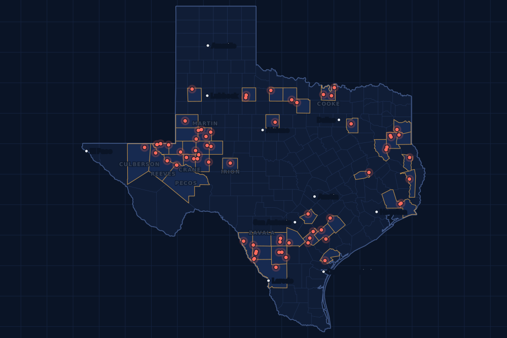
Counties and operators
Who drills, and where
Each county links to its Well Watch page, with its own map and every permit of the last two years. Each operator links to its page.
By county
- 1Martin County24
- 2Karnes County16
- 3Loving County14
- 4Pecos County13
- 5Reeves County12
- 6Upton County12
- 7La Salle County11
- 8Dimmit County10
- 9Crane County6
- 10Irion County6
- 11Culberson County5
- 12Zavala County5
- 13Atascosa County4
- 14Cooke County4
- 15Gaines County4
And 29 more counties with fewer, in the list below.
By operator
- 1EOG Resources, Inc.29
- 2Ovintiv USA Inc.16
- 3Continental Resources, Inc.13
- 4Anadarko E&P Onshore LLC12
- 5Firebird Energy II LLC9
- 6Pioneer Natural Res. USA, Inc.9
- 7Jonah Energy LLC8
- 8Blackbeard Operating, LLC6
- 9Triple Crown Resources, LLC6
- 10Blackbrush O & G, LLC5
- 11Coterra Energy Operating Co.5
- 12Marathon Oil Ef LLC5
- 13Javelin Energy Partners Mgmt LLC4
- 14OXY USA Inc.4
- 15Burlington Resources O & G Co LP3
And 38 more operators with fewer.
Register · June 8–14, 2026
Every permit, newest first
As the state files them: the lease and well, the operator, the kind of permit and the depth. “On the map” opens the county's live map at the well's spot.
Friday, June 1235 permits
- Archer CountyHorned Frog, well 1Eagle Oil & Gas Co. · new drill · vertical · 1,500 ftPermit 0916252 · API 42-009-43432On the map
- Baylor CountyWaggoner Swee, well 1661SWWaggoner Operating, L.L.C. · new drill · vertical · 6,500 ftPermit 0916384 · API 42-023-31872On the map
- Cherokee CountyVallier-Sessions, well 1HMaximus Operating, Ltd. · recompletion · horizontal · 15,000 ftPermit 0911304 · API 42-073-31589On the map
- Crane CountyPoop Deck, well 7407HBlackbeard Operating, LLC · new drill · horizontal · 7,999 ftPermit 0916342 · API 42-103-37817On the map
- Culberson CountyState Lord Murphy Unit 3-10, well 8HCoterra Energy Operating Co. · new drill · horizontal · 11,000 ftPermit 0915938 · API 42-109-34618On the map
- Culberson CountyState Lord Murphy Unit 3-10, well 7HCoterra Energy Operating Co. · new drill · horizontal · 11,000 ftPermit 0915936 · API 42-109-34617On the map
- Culberson CountyState Lord Murphy Unit 3-10, well 6HCoterra Energy Operating Co. · new drill · horizontal · 11,000 ftPermit 0915935 · API 42-109-34616On the map
- De Witt CountyWarren B-Warren A Sa 1, well 1HBPX Operating Company · new drill · horizontal · 14,000 ftPermit 0915667 · API 42-123-35784On the map
- Dimmit CountyBriscoe-Mcknight, well 01HEspada Energy, LLC · new drill · horizontal · 7,000 ftPermit 0916386 · API 42-127-39196On the map
- Dimmit CountyGrit Faith Sandy, well E 07HJonah Energy LLC · new drill · horizontal · 4,500 ftPermit 0916364 · API 42-127-39195On the map
- Frio CountyNeal, well 2Arete Operating Company, LLC · new drill · vertical · 4,200 ftPermit 0916360 · API 42-163-34420On the map
- Gaines CountySeminole San Andres Unit, well 4017OXY USA Inc. · recompletion · vertical · 5,800 ftPermit 0916344 · API 42-165-32881On the map
- Gaines CountySeminole San Andres Unit, well 4017OXY USA Inc. · recompletion · vertical · 5,800 ftPermit 0916343 · API 42-165-32881On the map
- Gaines CountySeminole San Andres Unit, well 3911OXY USA Inc. · recompletion · vertical · 5,800 ftPermit 0916339 · API 42-165-32873On the map
- Gaines CountySeminole San Andres Unit, well 3911OXY USA Inc. · recompletion · vertical · 5,800 ftPermit 0916334 · API 42-165-32873On the map
- Harrison CountyHunt Hl, well 1HPwep Operating, LLC · new drill · horizontal · 11,950 ftPermit 0915052 · API 42-203-35805On the map
- Karnes CountyFiesta A, well 101HEOG Resources, Inc. · new drill · horizontal · 11,500 ftPermit 0916212 · API 42-255-38422On the map
- La Salle CountyAltito B 8D Unit, well 84HVerdun Oil Ef II LLC · new drill · horizontal · 9,600 ftPermit 0916385 · API 42-283-37920On the map
- La Salle CountyAltito Bd, well 83HVerdun Oil Ef II LLC · new drill · horizontal · 9,600 ftPermit 0916377 · API 42-283-37919On the map
- Loving CountyWhite Knife, well 113HFe Permian Operating I, L.L.C. · new drill · horizontal · 10,900 ftPermit 0916379 · API 42-301-37896On the map
- Loving CountyWhite Knife, well 111HFe Permian Operating I, L.L.C. · new drill · horizontal · 10,900 ftPermit 0916378 · API 42-301-37895On the map
- Martin CountyTerlingua 255T, well 115HCOvintiv USA Inc. · new drill · horizontal · 10,500 ftPermit 0916369 · API 42-317-47337On the map
- Martin CountyTerlingua 255T, well 114HFOvintiv USA Inc. · new drill · horizontal · 10,500 ftPermit 0916367 · API 42-317-47336On the map
- Martin CountyTerlingua 255T, well 113HDOvintiv USA Inc. · new drill · horizontal · 10,500 ftPermit 0916366 · API 42-317-47334On the map
- Martin CountyTerlingua 255T, well 116HLOvintiv USA Inc. · new drill · horizontal · 10,500 ftPermit 0916356 · API 42-317-47333On the map
- Martin CountyEpley W7K, well 111HPioneer Natural Res. USA, Inc. · new drill · horizontal · 10,560 ftPermit 0915469 · API 42-317-47302On the map
- Martin CountyEpley W7J, well 110HPioneer Natural Res. USA, Inc. · new drill · horizontal · 10,560 ftPermit 0915463 · API 42-317-47301On the map
- Martin CountyEpley W7I, well 109HPioneer Natural Res. USA, Inc. · new drill · horizontal · 10,560 ftPermit 0915461 · API 42-317-47300On the map
- Martin CountyEpley W7H, well 108HPioneer Natural Res. USA, Inc. · new drill · horizontal · 10,560 ftPermit 0915459 · API 42-317-47299On the map
- Martin CountyEpley W7G, well 107HPioneer Natural Res. USA, Inc. · new drill · horizontal · 10,560 ftPermit 0915458 · API 42-317-47298On the map
- Midland CountyTurner H R40, well 3911HPioneer Natural Res. USA, Inc. · new drill · horizontal · 10,346 ftPermit 0916273 · API 42-329-48455On the map
- Rusk CountyS. S. Laird Gas Unit, well 6Wilson Resources, Inc. · recompletion · vertical · 10,280 ftPermit 0916388 · API 42-401-32768On the map
- Webb CountyLm 1870 F, well 120HEOG Resources, Inc. · new drill · horizontal · 14,500 ftPermit 0916305 · API 42-479-45657On the map
- Zavala CountyChittim Heirs, well 405HBlackbrush O & G, LLC · new drill · horizontal · 9,800 ftPermit 0916274 · API 42-507-33576On the map
- Zavala CountyChittim Heirs, well 21HBlackbrush O & G, LLC · new drill · horizontal · 5,500 ftPermit 0916173 · API 42-507-33572On the map
Thursday, June 1138 permits
- Atascosa CountyBowman East 344, well M344Javelin Energy Partners Mgmt LLC · new drill · horizontal · 9,000 ftPermit 0915769 · API 42-013-36286On the map
- Atascosa CountyBowman East 343, well M343Javelin Energy Partners Mgmt LLC · new drill · horizontal · 9,000 ftPermit 0915768 · API 42-013-36285On the map
- Atascosa CountyBowman East 342, well M342Javelin Energy Partners Mgmt LLC · new drill · horizontal · 9,000 ftPermit 0915767 · API 42-013-36032On the map
- Atascosa CountyBowman East 341, well M341Javelin Energy Partners Mgmt LLC · new drill · horizontal · 9,000 ftPermit 0915766 · API 42-013-36031On the map
- Culberson CountyState Lord Murphy Unit 3-10, well 5HCoterra Energy Operating Co. · new drill · horizontal · 11,000 ftPermit 0915932 · API 42-109-34615On the map
- Culberson CountyState Lord Murphy Unit 3-10, well 4HCoterra Energy Operating Co. · new drill · horizontal · 11,000 ftPermit 0915931 · API 42-109-34614On the map
- Dimmit CountyGrit Faith Sandy, well E 05HJonah Energy LLC · new drill · horizontal · 4,500 ftPermit 0916359 · API 42-127-39194On the map
- Dimmit CountyGrit Faith Sandy, well E 03HJonah Energy LLC · new drill · horizontal · 4,500 ftPermit 0916336 · API 42-127-39193On the map
- Dimmit CountyTocquigny Ac, well 701HAtlas Operating LLC · new drill · horizontal · 3,800 ftPermit 0916294 · API 42-127-39191On the map
- Dimmit CountyGrit Faith Sandy, well B 08HJonah Energy LLC · new drill · horizontal · 4,500 ftPermit 0916290 · API 42-127-39190On the map
- Irion CountyLittle Joe, well S866HTriple Crown Resources, LLC · new drill · horizontal · 9,000 ftPermit 0916329 · API 42-235-36783On the map
- Irion CountyLittle Joe, well S864HTriple Crown Resources, LLC · new drill · horizontal · 9,000 ftPermit 0916328 · API 42-235-36782On the map
- Irion CountyLittle Joe, well S863HTriple Crown Resources, LLC · new drill · horizontal · 9,000 ftPermit 0916327 · API 42-235-36781On the map
- Irion CountyLittle Joe, well S862HTriple Crown Resources, LLC · new drill · horizontal · 9,000 ftPermit 0916326 · API 42-235-36780On the map
- Irion CountyLittle Joe, well S861HTriple Crown Resources, LLC · new drill · horizontal · 9,000 ftPermit 0916325 · API 42-235-36779On the map
- Irion CountyLittle Joe, well S861HTriple Crown Resources, LLC · new drill · horizontal · 9,000 ftPermit 0916324 · API 42-235-36778On the map
- La Salle CountySP5 B, well 502HCaturus Energy, LLC · new drill · horizontal · 17,500 ftPermit 0916061 · API 42-283-37909On the map
- Lavaca CountyNaboo B Mipa Unit, well 2HFW Eagle Ford I, LLC · new drill · horizontal · 11,478 ftPermit 0915740 · API 42-285-34372On the map
- Loving CountyState Apollo Xl F, well 752HEOG Resources, Inc. · new drill · horizontal · 14,000 ftPermit 0916269 · API 42-301-37894On the map
- Loving CountyState Apollo Xl E, well 762HEOG Resources, Inc. · new drill · horizontal · 14,000 ftPermit 0916268 · API 42-301-37893On the map
- Loving CountyState Apollo Xl D, well 732HEOG Resources, Inc. · new drill · horizontal · 14,000 ftPermit 0916267 · API 42-301-37892On the map
- Loving CountyState Apollo Xl C, well 751HEOG Resources, Inc. · new drill · horizontal · 14,000 ftPermit 0916266 · API 42-301-37891On the map
- Loving CountyState Apollo Xl B, well 761HEOG Resources, Inc. · new drill · horizontal · 14,000 ftPermit 0916265 · API 42-301-37890On the map
- Loving CountyState Apollo Xl A, well 731HEOG Resources, Inc. · new drill · horizontal · 14,000 ftPermit 0916264 · API 42-301-37889On the map
- Martin CountyJensen 52, well 2Junction Resources Op, LLC · new drill · vertical · 5,000 ftPermit 0916016 · API 42-317-46006On the map
- Refugio CountyRooke. B.d., well 6907JRising Star Energy Partners II, · new drill · vertical · 7,300 ftPermit 0916216 · API 42-391-33350On the map
- Rusk CountyBethany-Lowe (Aw), well 1HTanos Exploration IV, LLC · new drill · horizontal · 8,398 ftPermit 0916316 · API 42-401-35502On the map
- Upton CountyNancy 2614, well 1CFFirebird Energy II LLC · new drill · horizontal · 11,000 ftPermit 0916330 · API 42-461-43681On the map
- Upton CountyNancy 2614 F, well 301HFirebird Energy II LLC · new drill · horizontal · 10,500 ftPermit 0916322 · API 42-461-43680On the map
- Upton CountyNancy 2614 E, well 201HFirebird Energy II LLC · new drill · horizontal · 10,500 ftPermit 0916321 · API 42-461-43679On the map
- Upton CountyNancy 2614 D, well 401HFirebird Energy II LLC · new drill · horizontal · 10,500 ftPermit 0916320 · API 42-461-43683On the map
- Upton CountyNancy 2614 C, well 501HFirebird Energy II LLC · new drill · horizontal · 10,500 ftPermit 0916319 · API 42-461-43682On the map
- Upton CountyNancy 2614 B, well 302HFirebird Energy II LLC · new drill · horizontal · 10,500 ftPermit 0916318 · API 42-461-43678On the map
- Upton CountyNancy 2614 A, well 101HFirebird Energy II LLC · new drill · horizontal · 10,500 ftPermit 0916317 · API 42-461-43676On the map
- Upton CountyNancy 2614 A, well 402HFirebird Energy II LLC · new drill · horizontal · 10,500 ftPermit 0916315 · API 42-461-43675On the map
- Upton CountyNancy 2614 A, well 502HFirebird Energy II LLC · new drill · horizontal · 10,500 ftPermit 0916314 · API 42-461-43674On the map
- Upton CountyAf A, well 2284WDDiscovery Operating, Inc. · new drill · horizontal · 11,500 ftPermit 0915280 · API 42-461-43620On the map
- Upton CountyAf A, well 2276WBDiscovery Operating, Inc. · new drill · horizontal · 10,500 ftPermit 0915276 · API 42-461-43619On the map
Wednesday, June 1052 permits
- Andrews CountyFee Bar B, well 8Fasken Oil and Ranch, Ltd. · new drill · horizontal · 12,300 ftPermit 0916149 · API 42-003-49352On the map
- Cooke CountyVoth, Craig, well 1Felderhoff Production Company · new drill · vertical · 2,200 ftPermit 0916291 · API 42-097-34866On the map
- Cooke CountyBonner, well 23Felderhoff Production Company · new drill · vertical · 3,400 ftPermit 0916271 · API 42-097-34865On the map
- Cooke CountyBonner, well 22Felderhoff Production Company · new drill · vertical · 3,400 ftPermit 0916270 · API 42-097-34864On the map
- Crane CountyMcknight Sand Hills Unit, well 7308HBlackbeard Operating, LLC · new drill · horizontal · 7,999 ftPermit 0916353 · API 42-103-37816On the map
- Crane CountyMcknight Sand Hills Unit, well 7307HBlackbeard Operating, LLC · new drill · horizontal · 7,999 ftPermit 0916351 · API 42-103-37815On the map
- Crane CountyMcknight Sand Hills Unit, well 7107HBlackbeard Operating, LLC · new drill · horizontal · 7,999 ftPermit 0916347 · API 42-103-37813On the map
- Crane CountyMcknight Sand Hills Unit, well 7108HBlackbeard Operating, LLC · new drill · horizontal · 7,999 ftPermit 0916349 · API 42-103-37814On the map
- De Witt CountyBeard Etal Gu, well 1Hurd Enterprises, Ltd. · new drill · vertical · 11,500 ftPermit 0915966 · API 42-123-35786On the map
- Dimmit CountyGrit Faith Sandy, well E 01HJonah Energy LLC · new drill · horizontal · 4,500 ftPermit 0916331 · API 42-127-39192On the map
- Dimmit CountyGrit Faith Sandy, well B 06HJonah Energy LLC · new drill · horizontal · 4,500 ftPermit 0916289 · API 42-127-39189On the map
- Dimmit CountyGrit Faith Sandy, well B 04HJonah Energy LLC · new drill · horizontal · 4,500 ftPermit 0916288 · API 42-127-39188On the map
- Dimmit CountyGrit Faith Sandy, well B 02HJonah Energy LLC · new drill · horizontal · 4,500 ftPermit 0916287 · API 42-127-39187On the map
- Ector CountySallie B 12-48 E, well 5HDiamondback E&P LLC · new drill · horizontal · 12,500 ftPermit 0915962 · API 42-135-44266On the map
- Glasscock CountyBrunson 13-24C, well 3HUPioneer Natural Res. USA, Inc. · new drill · horizontal · 10,100 ftPermit 0915611 · API 42-173-39555On the map
- Glasscock CountyBrunson 13-24B, well 2HUPioneer Natural Res. USA, Inc. · new drill · horizontal · 10,100 ftPermit 0915610 · API 42-173-39554On the map
- Glasscock CountyBrunson 13-24A, well 1HUPioneer Natural Res. USA, Inc. · new drill · horizontal · 10,100 ftPermit 0915609 · API 42-173-39553On the map
- Jack CountyDavis 'D', well 4Pop Operating Company · new drill · vertical · 3,700 ftPermit 0916297 · API 42-237-40724On the map
- Jefferson CountySunflower 2 Azm, well 2Exxonmobil Low C Sol on Stor LLC · new drill · vertical · 4,000 ftPermit 0916286 · API 42-245-32938On the map
- Karnes CountyJohnson-Forister Sa G, well 1Burlington Resources O & G Co LP · new drill · horizontal · 17,500 ftPermit 0916276 · API 42-255-38421On the map
- Karnes CountyJohnson-Forister Sa F, well 3Burlington Resources O & G Co LP · new drill · horizontal · 17,500 ftPermit 0916275 · API 42-255-38420On the map
- King CountyCroton Creek, well 1Halliburton Operating Company · new drill · vertical · 4,000 ftPermit 0916295 · API 42-269-33071On the map
- Liberty CountySunflower 1 Azm, well 1Exxonmobil Low C Sol on Stor LLC · new drill · vertical · 4,000 ftPermit 0916285 · API 42-291-32978On the map
- Madison CountyJoyce D Unit, well 102Empire Texas Operating LLC · recompletion · vertical · 18,000 ftPermit 0916220 · API 42-313-31176On the map
- Martin CountyTerlingua 255S, well 111HFOvintiv USA Inc. · new drill · horizontal · 10,500 ftPermit 0916246 · API 42-317-47328On the map
- Martin CountyTerlingua 255S, well 112HJOvintiv USA Inc. · new drill · horizontal · 10,500 ftPermit 0916243 · API 42-317-47327On the map
- Martin CountyTerlingua 255S, well 109HLOvintiv USA Inc. · new drill · horizontal · 10,500 ftPermit 0916230 · API 42-317-47326On the map
- Martin CountyTerlingua 255S, well 110HROvintiv USA Inc. · new drill · horizontal · 11,000 ftPermit 0916229 · API 42-317-47325On the map
- Martin CountyTerlingua 255R, well 108HDOvintiv USA Inc. · new drill · horizontal · 10,500 ftPermit 0916228 · API 42-317-47324On the map
- Martin CountyTerlingua 255R, well 105HCOvintiv USA Inc. · new drill · horizontal · 10,500 ftPermit 0916227 · API 42-317-47323On the map
- Martin CountyTerlingua 255R, well 107HFOvintiv USA Inc. · new drill · horizontal · 10,500 ftPermit 0916225 · API 42-317-47322On the map
- Martin CountyTerlingua 255Q, well 104HJOvintiv USA Inc. · new drill · horizontal · 10,500 ftPermit 0916224 · API 42-317-47321On the map
- Martin CountyTerlingua 255Q, well 103HLOvintiv USA Inc. · new drill · horizontal · 10,500 ftPermit 0916223 · API 42-317-47320On the map
- Martin CountyTerlingua 255Q, well 102HDOvintiv USA Inc. · new drill · horizontal · 10,500 ftPermit 0916222 · API 42-317-47319On the map
- Martin CountyTerlingua 255Q, well 101HFOvintiv USA Inc. · new drill · horizontal · 10,500 ftPermit 0916215 · API 42-317-47318On the map
- Martin CountyTerlingua 255Q, well 106HROvintiv USA Inc. · new drill · horizontal · 10,900 ftPermit 0916185 · API 42-317-47317On the map
- Panola CountyHemby-Vsu Ha (Aw), well 1HTanos Exploration IV, LLC · new drill · horizontal · 11,470 ftPermit 0916191 · API 42-365-39032On the map
- Pecos CountyPecan State Unit, well 1607HContinental Resources, Inc. · new drill · horizontal · 11,761 ftPermit 0916313 · API 42-371-40551On the map
- Pecos CountyPecan State Unit, well 1606HContinental Resources, Inc. · new drill · horizontal · 11,761 ftPermit 0916312 · API 42-371-40550On the map
- Pecos CountyPecan State Unit, well 1605HContinental Resources, Inc. · new drill · horizontal · 11,761 ftPermit 0916311 · API 42-371-40549On the map
- Pecos CountyPecan State Unit, well 1604HContinental Resources, Inc. · new drill · horizontal · 11,761 ftPermit 0916310 · API 42-371-40548On the map
- Pecos CountyPecan State Unit, well 1603HContinental Resources, Inc. · new drill · horizontal · 11,761 ftPermit 0916309 · API 42-371-40547On the map
- Pecos CountyPecan State Unit, well 1602HContinental Resources, Inc. · new drill · horizontal · 11,761 ftPermit 0916308 · API 42-371-40546On the map
- Pecos CountyPecan State Unit, well 1601HContinental Resources, Inc. · new drill · horizontal · 11,761 ftPermit 0916307 · API 42-371-40545On the map
- Pecos CountyPecan State Unit, well 1506HContinental Resources, Inc. · new drill · horizontal · 11,761 ftPermit 0916306 · API 42-371-40544On the map
- Pecos CountyPecan State Unit, well 1505HContinental Resources, Inc. · new drill · horizontal · 11,761 ftPermit 0916304 · API 42-371-40543On the map
- Pecos CountyPecan State Unit, well 1504HContinental Resources, Inc. · new drill · horizontal · 11,761 ftPermit 0916303 · API 42-371-40542On the map
- Pecos CountyPecan State Unit, well 1503HContinental Resources, Inc. · new drill · horizontal · 11,761 ftPermit 0916302 · API 42-371-40541On the map
- Pecos CountyPecan State Unit, well 1502HContinental Resources, Inc. · new drill · horizontal · 11,761 ftPermit 0916300 · API 42-371-40540On the map
- Pecos CountyPecan State Unit, well 1501HContinental Resources, Inc. · new drill · horizontal · 11,761 ftPermit 0916299 · API 42-371-40539On the map
- Zavala CountyChittim Heirs, well 24HBlackbrush O & G, LLC · new drill · horizontal · 5,500 ftPermit 0916221 · API 42-507-33575On the map
- Zavala CountyChittim Heirs, well 22HBlackbrush O & G, LLC · new drill · horizontal · 5,500 ftPermit 0916197 · API 42-507-33573On the map
Tuesday, June 937 permits
- Andrews CountyFee Bar B, well 6Fasken Oil and Ranch, Ltd. · new drill · horizontal · 12,300 ftPermit 0916146 · API 42-003-49350On the map
- Cooke CountyClegg, well 2HOil Capital Operating, LLC · new drill · horizontal · 16,500 ftPermit 0916118 · API 42-097-34863On the map
- Frio CountyOld Laredo-Unit-B, well S738HFormentera Operations LLC · new drill · horizontal · 11,200 ftPermit 0916250 · API 42-163-34418On the map
- Frio CountyOld Laredo-Unit-A, well S735HFormentera Operations LLC · new drill · horizontal · 11,200 ftPermit 0916251 · API 42-163-34419On the map
- Jasper CountyGran Torino Sn, well 1HRZarvona Energy LLC · new drill · horizontal · 15,000 ftPermit 0916358 · API 42-241-30937On the map
- Karnes CountyJohnson-Forister Usw, well F 2Burlington Resources O & G Co LP · new drill · horizontal · 17,500 ftPermit 0916196 · API 42-255-38412On the map
- Karnes CountyWeston-Pmt Sa E, well 1Marathon Oil Ef LLC · new drill · horizontal · 17,500 ftPermit 0916010 · API 42-255-38409On the map
- Karnes CountyWeston-Pmt Sa D, well 1Marathon Oil Ef LLC · new drill · horizontal · 17,500 ftPermit 0916009 · API 42-255-38408On the map
- Karnes CountyWeston-Pmt Sa C, well 1Marathon Oil Ef LLC · new drill · horizontal · 17,500 ftPermit 0916008 · API 42-255-38407On the map
- Karnes CountyWeston-West-Pmt Sa B, well 1Marathon Oil Ef LLC · new drill · horizontal · 17,500 ftPermit 0916006 · API 42-255-38406On the map
- Karnes CountyWeston-West-Pmt Sa A, well 1Marathon Oil Ef LLC · new drill · horizontal · 17,500 ftPermit 0916005 · API 42-255-38405On the map
- La Salle CountyPeter J, well 9HEOG Resources, Inc. · new drill · horizontal · 10,300 ftPermit 0916179 · API 42-283-37917On the map
- La Salle CountyPeter H, well 8HEOG Resources, Inc. · new drill · horizontal · 10,300 ftPermit 0916178 · API 42-283-37916On the map
- La Salle CountyPeter G, well 7HEOG Resources, Inc. · new drill · horizontal · 10,300 ftPermit 0916177 · API 42-283-37915On the map
- La Salle CountyPeter F, well 6HEOG Resources, Inc. · new drill · horizontal · 10,300 ftPermit 0916175 · API 42-283-37914On the map
- La Salle CountyPeter E, well 5HEOG Resources, Inc. · new drill · horizontal · 10,300 ftPermit 0916172 · API 42-283-37913On the map
- La Salle CountyPeter D, well 4HEOG Resources, Inc. · new drill · horizontal · 10,300 ftPermit 0916171 · API 42-283-37912On the map
- La Salle CountyPeter C, well 3HEOG Resources, Inc. · new drill · horizontal · 10,300 ftPermit 0916170 · API 42-283-37911On the map
- La Salle CountyPeter B, well 2HEOG Resources, Inc. · new drill · horizontal · 10,300 ftPermit 0916169 · API 42-283-37918On the map
- Maverick CountyCp# 26-105 Cathodic Protection, well 37Texas Pipeline LLC · new drill · vertical · 330 ftPermit 0916214 · API 42-323-33696On the map
- Reeves CountyWizard 56-3-28-29 L, well 19HAnadarko E&P Onshore LLC · new drill · horizontal · 13,000 ftPermit 0916244 · API 42-389-42178On the map
- Reeves CountyWizard 56-3-28-29 K, well 25HAnadarko E&P Onshore LLC · new drill · horizontal · 13,000 ftPermit 0916242 · API 42-389-42177On the map
- Reeves CountyWizard 56-3-28-29 J, well 19HAnadarko E&P Onshore LLC · new drill · horizontal · 13,000 ftPermit 0916241 · API 42-389-42176On the map
- Reeves CountyWizard 56-3-28-29 I, well 25HAAnadarko E&P Onshore LLC · new drill · horizontal · 13,000 ftPermit 0916240 · API 42-389-42175On the map
- Reeves CountyWizard 56-3-28-29 H, well 18HAnadarko E&P Onshore LLC · new drill · horizontal · 13,000 ftPermit 0916239 · API 42-389-42174On the map
- Reeves CountyWizard 56-3-28-29 G, well 17HAAnadarko E&P Onshore LLC · new drill · horizontal · 13,000 ftPermit 0916238 · API 42-389-42173On the map
- Reeves CountyWizard 56-3-28-29 F, well 16HAAnadarko E&P Onshore LLC · new drill · horizontal · 13,000 ftPermit 0916237 · API 42-389-42172On the map
- Reeves CountyWizard 56-3-28-29 E, well 14HAAnadarko E&P Onshore LLC · new drill · horizontal · 13,000 ftPermit 0916235 · API 42-389-42171On the map
- Reeves CountyWizard 56-3-28-29 D, well 13HAAnadarko E&P Onshore LLC · new drill · horizontal · 13,000 ftPermit 0916234 · API 42-389-42169On the map
- Reeves CountyWizard 56-3-28-29 C, well 12HAAnadarko E&P Onshore LLC · new drill · horizontal · 13,000 ftPermit 0916233 · API 42-389-42168On the map
- Reeves CountyWizard 56-3-28-29 B, well 23HAAnadarko E&P Onshore LLC · new drill · horizontal · 13,000 ftPermit 0916232 · API 42-389-42167On the map
- Reeves CountyWizard 56-3-28-29 A, well 11HAAnadarko E&P Onshore LLC · new drill · horizontal · 13,000 ftPermit 0916231 · API 42-389-42166On the map
- Refugio CountyRooke. B.d., well 6908JRising Star Energy Partners II, · new drill · vertical · 7,300 ftPermit 0916217 · API 42-391-33352On the map
- San Augustine CountyRoyal Troon Ra, well 1HBRockcliff Energy Operating III · new drill · horizontal · 16,000 ftPermit 0916062 · API 42-405-30962On the map
- Shackelford CountySimpson, well 4Stasney Well Service, LLC · new drill · vertical · 990 ftPermit 0916256 · API 42-417-39836On the map
- Shackelford CountySimpson, well 3Stasney Well Service, LLC · new drill · vertical · 990 ftPermit 0916219 · API 42-417-39835On the map
- Ward CountyJ. F. Pattee Et Al Unit, well 5RJetta Operating Company, Inc. · new drill · vertical · 7,500 ftPermit 0916323 · API 42-475-39078On the map
Monday, June 825 permits
- Andrews CountyFee Bar B, well 7Fasken Oil and Ranch, Ltd. · new drill · horizontal · 12,300 ftPermit 0916148 · API 42-003-49351On the map
- Crane CountyUl Cazador 16/4 F, well F101OJMewbourne Oil Company · new drill · horizontal · 9,859 ftPermit 0916048 · API 42-103-37812On the map
- Guadalupe CountyHuber Rd Unit, well 1Energy Transfer Company · new drill · vertical · 400 ftPermit 0916140 · API 42-187-33725On the map
- Hockley CountyValiant A, well 1HBeryl Oil and Gas, LP · new drill · horizontal · 4,500 ftPermit 0916129 · API 42-219-37579On the map
- Karnes CountyFiesta G, well 7HEOG Resources, Inc. · new drill · horizontal · 12,000 ftPermit 0916211 · API 42-255-38419On the map
- Karnes CountyFiesta F, well 6HEOG Resources, Inc. · new drill · horizontal · 12,000 ftPermit 0916210 · API 42-255-38418On the map
- Karnes CountyFiesta E, well 5HEOG Resources, Inc. · new drill · horizontal · 12,000 ftPermit 0916209 · API 42-255-38417On the map
- Karnes CountyFiesta D, well 4HEOG Resources, Inc. · new drill · horizontal · 12,000 ftPermit 0916208 · API 42-255-38416On the map
- Karnes CountyFiesta C, well 3HEOG Resources, Inc. · new drill · horizontal · 12,000 ftPermit 0916207 · API 42-255-38415On the map
- Karnes CountyFiesta B, well 2HEOG Resources, Inc. · new drill · horizontal · 12,000 ftPermit 0916206 · API 42-255-38414On the map
- Karnes CountyFiesta A, well 1HEOG Resources, Inc. · new drill · horizontal · 12,000 ftPermit 0916205 · API 42-255-38413On the map
- Kaufman CountyS1-MP 269.215, well 1Enterprise Products Operatingllc · new drill · vertical · 400 ftPermit 0915645 · API 42-257-30449On the map
- King CountyPearls, well 2Halliburton Operating Company · new drill · vertical · 4,000 ftPermit 0915735 · API 42-269-33070On the map
- Loving CountyStone Cutter O, well 755HEOG Resources, Inc. · new drill · horizontal · 14,000 ftPermit 0916161 · API 42-301-37888On the map
- Loving CountyStone Cutter N, well 754HEOG Resources, Inc. · new drill · horizontal · 14,000 ftPermit 0916160 · API 42-301-37887On the map
- Loving CountyStone Cutter M, well 753HEOG Resources, Inc. · new drill · horizontal · 14,000 ftPermit 0916159 · API 42-301-37886On the map
- Loving CountyStone Cutter Q, well 762HEOG Resources, Inc. · new drill · horizontal · 14,000 ftPermit 0916158 · API 42-301-37885On the map
- Loving CountyStone Cutter L, well 752HEOG Resources, Inc. · new drill · horizontal · 14,000 ftPermit 0916157 · API 42-301-37884On the map
- Loving CountyStone Cutter P, well 761HEOG Resources, Inc. · new drill · horizontal · 14,000 ftPermit 0916156 · API 42-301-37883On the map
- Martin CountyUl Audible 44-27 G, well 1WDDiamondback E&P LLC · new drill · horizontal · 13,000 ftPermit 0916193 · API 42-317-47316On the map
- Martin CountyUl Comanche 44-27 A, well 1WDDiamondback E&P LLC · new drill · horizontal · 13,000 ftPermit 0916192 · API 42-317-47315On the map
- Rusk CountyYandle Unit No. 2, well 1Buffco Production Inc. · recompletion · vertical · 10,820 ftPermit 0916134 · API 42-401-30950On the map
- Upton CountyElliott Ranch SWD, well 2Xri Disposal Holdings, LLC · new drill · vertical · 5,700 ftPermit 0915507 · API 42-461-43630On the map
- Winkler CountyKraken 12-11 1G, well 327HBlackbeard Operating, LLC · new drill · horizontal · 7,999 ftPermit 0916042 · API 42-495-35192On the map
- Zavala CountyChittim Heirs, well 23HBlackbrush O & G, LLC · new drill · horizontal · 5,500 ftPermit 0916213 · API 42-507-33574On the map
Cancelled permits are left out. To look a permit up at the source, use the Railroad Commission's drilling permit query with its permit number.
Archive
Earlier weeks
Each finished week, Monday to Sunday, has its own page that does not change. The feed gets one entry per week.
- Nov 9–15, 2026103
- Nov 2–8, 2026164
- Oct 26 – Nov 1, 2026242
- Oct 19–25, 2026215
- Oct 12–18, 2026147
- Oct 5–11, 2026152
- Sep 28 – Oct 4, 2026156
- Sep 21–27, 2026194
- Sep 14–20, 2026167
- Sep 7–13, 2026133
- Aug 31 – Sep 6, 2026182
- Aug 24–30, 2026118
Every week since January 1, 2024 (150 weeks)
2026
- Aug 17–23167
- Aug 10–16198
- Aug 3–9186
- Jul 27 – Aug 2143
- Jul 20–26170
- Jul 13–19117
- Jul 6–12194
- Jun 29 – Jul 5114
- Jun 22–28175
- Jun 15–21186
- Jun 8–14187
- Jun 1–7154
- May 25–31158
- May 18–24197
- May 11–17182
- May 4–10190
- Apr 27 – May 3156
- Apr 20–26210
- Apr 13–19133
- Apr 6–12206
- Mar 30 – Apr 5129
- Mar 23–29159
- Mar 16–22167
- Mar 9–15166
- Mar 2–8140
- Feb 23 – Mar 1181
- Feb 16–22141
- Feb 9–15133
- Feb 2–8124
- Jan 26 – Feb 1126
- Jan 19–25189
- Jan 12–18280
- Jan 5–11129
2025
- Dec 29 – Jan 4, 202656
- Dec 22–2846
- Dec 15–21154
- Dec 8–14119
- Dec 1–7128
- Nov 24–3061
- Nov 17–23140
- Nov 10–1698
- Nov 3–9107
- Oct 27 – Nov 2137
- Oct 20–26145
- Oct 13–19173
- Oct 6–12206
- Sep 29 – Oct 5124
- Sep 22–28141
- Sep 15–21165
- Sep 8–14127
- Sep 1–7105
- Aug 25–31145
- Aug 18–24115
- Aug 11–17140
- Aug 4–10131
- Jul 28 – Aug 3134
- Jul 21–27151
- Jul 14–20151
- Jul 7–13148
- Jun 30 – Jul 6148
- Jun 23–29167
- Jun 16–22118
- Jun 9–15115
- Jun 2–8147
- May 26 – Jun 190
- May 19–25148
- May 12–18120
- May 5–11114
- Apr 28 – May 4135
- Apr 21–27182
- Apr 14–20115
- Apr 7–13197
- Mar 31 – Apr 6194
- Mar 24–30170
- Mar 17–23189
- Mar 10–16177
- Mar 3–9141
- Feb 24 – Mar 2172
- Feb 17–23145
- Feb 10–16170
- Feb 3–9167
- Jan 27 – Feb 2149
- Jan 20–26158
- Jan 13–19176
- Jan 6–12140
2024
- Dec 30 – Jan 5, 202597
- Dec 23–295
- Dec 16–22168
- Dec 9–15202
- Dec 2–8182
- Nov 25 – Dec 189
- Nov 18–24189
- Nov 11–17145
- Nov 4–10152
- Oct 28 – Nov 3134
- Oct 21–27163
- Oct 14–20147
- Oct 7–13114
- Sep 30 – Oct 6138
- Sep 23–29133
- Sep 16–22175
- Sep 9–15144
- Sep 2–8138
- Aug 26 – Sep 1177
- Aug 19–25207
- Aug 12–18186
- Aug 5–11145
- Jul 29 – Aug 4191
- Jul 22–28174
- Jul 15–21164
- Jul 8–14205
- Jul 1–7106
- Jun 24–30183
- Jun 17–23192
- Jun 10–16161
- Jun 3–9176
- May 27 – Jun 2135
- May 20–26223
- May 13–19169
- May 6–12155
- Apr 29 – May 5191
- Apr 22–28224
- Apr 15–21200
- Apr 8–14157
- Apr 1–7149
- Mar 25–31102
- Mar 18–24130
- Mar 11–17228
- Mar 4–10178
- Feb 26 – Mar 3187
- Feb 19–25164
- Feb 12–18190
- Feb 5–11137
- Jan 29 – Feb 4177
- Jan 22–28172
- Jan 15–21107
- Jan 8–14251
- Jan 1–7148
FAQ
Questions people ask
What is a drilling permit?
Permission from the Railroad Commission of Texas to drill a well, or to re-enter or deepen an old one, at a stated spot and to a stated depth. An operator files for it before the rig comes; it lasts two years. Many permitted wells are drilled within months, some never are.
Is this week complete?
Yes. The state has issued permits on later days, so this week's list is closed. A permit the state cancels later drops off the list.
Some permits are not on the map. Why?
The map draws a permit at the well's surface location as the state files it. A new permit's location can take a few days to reach the state's files; until then it is listed here but not drawn.
Does a new permit near my land mean I will be paid?
No. A permit says where a well may be drilled, not whose minerals it will produce or who is paid. That depends on your lease, the unit the well is pooled in and the division order. If a well is drilled on or next to your tract, watch for a division order from the operator.
Can I get these by email or in a feed?
Yes. The feed on this page has one entry for each finished week, for any feed reader. For one county, an abstract or a lease, Texas Well Watch sends one email a week when the state files something new there; it is free with an account.
Sources
- Railroad Commission of Texas, drilling permit master and trailer, daily file (with latitudes and longitudes)www.rrc.texas.gov/resource-center/research/data-sets-available-for-download/ · loaded every night; newest permit on file November 20, 2026
- Railroad Commission of Texas, drilling permit query (one permit at the source)webapps.rrc.texas.gov/DP/initializePublicQueryAction.do · linked, not read
- US Census Bureau, cartographic boundary files (county lines), through the us-atlas package 3.0.1www.census.gov/geographies/mapping-files/time-series/geo/cartographic-boundary.html · built into the site with its well maps
- GeoNames, towns and their points (CC BY 4.0)www.geonames.org/ · built into the site with its town pages