
Railroad Commission of Texas · week of July 29, 2024
New Texas drilling permits, Jul 29 – Aug 4, 2024
- 191permits issued
- 155horizontal
- 55counties
- 62operators
That week
Where the state permitted wells
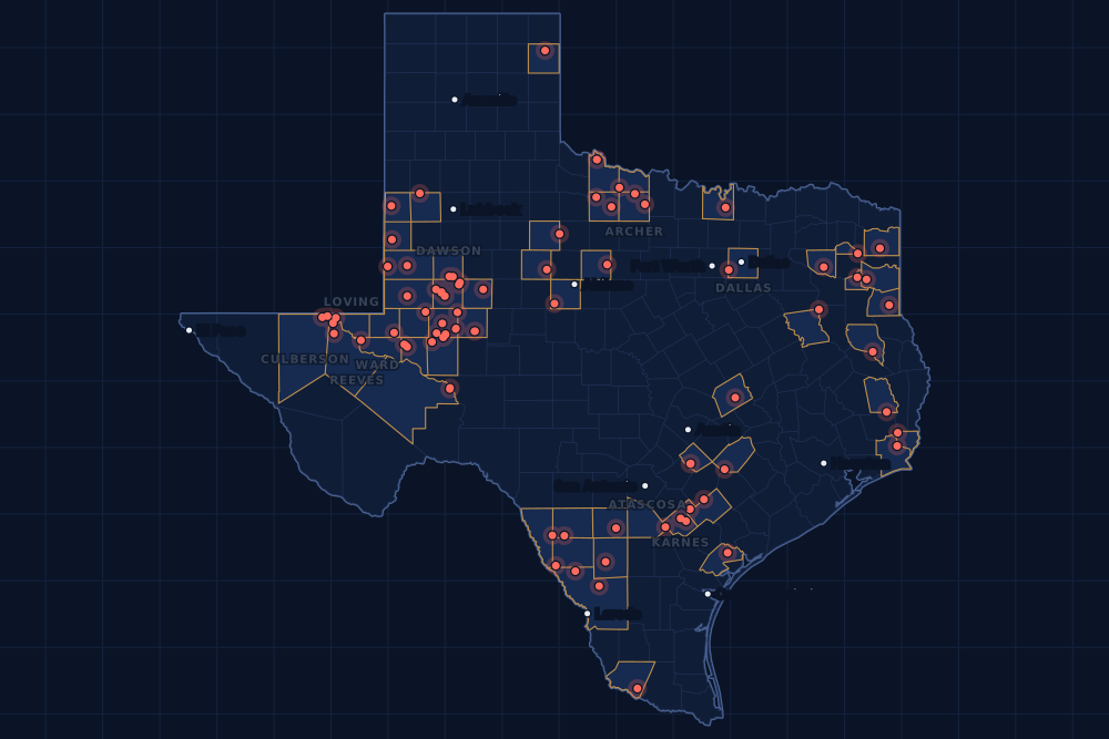
Counties and operators
Who drills, and where
Each county links to its Well Watch page, with its own map and every permit of the last two years. Each operator links to its page.
By county
- 1Martin County39
- 2Midland County30
- 3Reeves County11
- 4Glasscock County10
- 5Karnes County9
- 6Dallas County7
- 7Culberson County6
- 8Dawson County4
- 9Loving County4
- 10Ward County4
- 11Webb County4
- 12Archer County3
- 13Atascosa County3
- 14Caldwell County3
- 15Crane County3
And 40 more counties with fewer, in the list below.
By operator
- 1Pioneer Natural Res. USA, Inc.25
- 2De IV Operating, LLC12
- 3Ovintiv USA Inc.11
- 4Anadarko E&P Onshore LLC10
- 5Black Swan Opco, LLC10
- 6SM Energy Company9
- 7Diamondback E&P LLC7
- 8Tep Barnett USA, LLC7
- 9Devon Energy Production Co, L.P.6
- 10Apache Corporation5
- 11Marathon Oil Ef LLC5
- 12XTO Energy Inc.5
- 13Blackbeard Operating, LLC4
- 14Petro-Hunt Permian, LLC4
- 15Burk Royalty Co., Ltd.3
And 47 more operators with fewer.
Register · July 29 – August 4, 2024
Every permit, newest first
As the state files them: the lease and well, the operator, the kind of permit and the depth. “On the map” opens the county's live map at the well's spot.
Friday, August 256 permits
- Cass CountyLockett, well 1HRose City Resources, LLC · new drill · horizontal · 13,000 ftPermit 0900052 · API 42-067-30949On the map
- Cochran CountyBlack Jack, well 1HManzano, LLC · new drill · horizontal · 5,500 ftPermit 0901658 · API 42-079-33435On the map
- Culberson CountyBlackjack, well 809HConocophillips Company · new drill · horizontal · 10,500 ftPermit 0901723 · API 42-109-34314On the map
- Culberson CountyMacbeth 22-27 M, well 14HCimarex Energy Co. · new drill · horizontal · 15,000 ftPermit 0901662 · API 42-109-34301On the map
- Culberson CountyMacbeth 22-27 L, well 13HCimarex Energy Co. · new drill · horizontal · 15,000 ftPermit 0901661 · API 42-109-34300On the map
- Culberson CountyMacbeth 22-27 K, well 12HCimarex Energy Co. · new drill · horizontal · 15,000 ftPermit 0901660 · API 42-109-34299On the map
- Culberson CountyMacbeth 22-27 N, well 15HCoterra Energy Operating Co. · new drill · horizontal · 15,000 ftPermit 0901663 · API 42-109-34302On the map
- Dawson CountyPinnacles 33-45 C, well 10DNIke Operating, LLC · new drill · horizontal · 9,100 ftPermit 0901722 · API 42-115-33999On the map
- Dawson CountyPinnacles 33-45 B, well 6DNIke Operating, LLC · new drill · horizontal · 9,100 ftPermit 0901721 · API 42-115-33998On the map
- Dawson CountyPinnacles 33-45 A, well 3DNIke Operating, LLC · new drill · horizontal · 9,100 ftPermit 0901720 · API 42-115-33997On the map
- Gaines CountyBranex/American, well 28Texland Petroleum, L.P. · new drill · vertical · 6,900 ftPermit 0901747 · API 42-165-38960On the map
- Hemphill CountyUrschel 49/50 A, well C001GAMewbourne Oil Company · new drill · horizontal · 9,170 ftPermit 0901530 · API 42-211-35673On the map
- Howard CountyShenandoah 11-2-58 Xl, well H 3WABayswater Operating Company LLC · new drill · horizontal · 7,800 ftPermit 0901638 · API 42-227-42552On the map
- Karnes CountyLinhart Patton Wilson Psa B, well 2HMurphy Expl. & Prod. Co. - USA · new drill · horizontal · 13,000 ftPermit 0901492 · API 42-255-38126On the map
- Loving CountyGar Unit, well 302HApache Corporation · new drill · horizontal · 16,000 ftPermit 0901633 · API 42-301-37047On the map
- Loving CountyGar Unit, well 202HApache Corporation · new drill · horizontal · 16,000 ftPermit 0901632 · API 42-301-37046On the map
- Loving CountyGar Unit, well 301HApache Corporation · new drill · horizontal · 16,000 ftPermit 0901631 · API 42-301-37045On the map
- Loving CountyGar Unit, well 201HApache Corporation · new drill · horizontal · 16,000 ftPermit 0901629 · API 42-301-37044On the map
- Martin CountyBlagrave G 42-43, well 4207HDe IV Operating, LLC · new drill · horizontal · 10,605 ftPermit 0901764 · API 42-317-46401On the map
- Martin CountyBlagrave G 42-43, well 6207HDe IV Operating, LLC · new drill · horizontal · 10,605 ftPermit 0901763 · API 42-317-46398On the map
- Martin CountyBlagrave F 42-43, well 3006HDe IV Operating, LLC · new drill · horizontal · 10,605 ftPermit 0901762 · API 42-317-46395On the map
- Martin CountyBlagrave F 42-43, well 4406HDe IV Operating, LLC · new drill · horizontal · 10,605 ftPermit 0901761 · API 42-317-46391On the map
- Martin CountyBlagrave D 42-43, well 2804HDe IV Operating, LLC · new drill · horizontal · 10,605 ftPermit 0901759 · API 42-317-46389On the map
- Martin CountyBlagrave D 42-43, well 4204HDe IV Operating, LLC · new drill · horizontal · 10,605 ftPermit 0901758 · API 42-317-46388On the map
- Martin CountyBlagrave B 42-43, well 3002HDe IV Operating, LLC · new drill · horizontal · 10,605 ftPermit 0901757 · API 42-317-46387On the map
- Martin CountyBlagrave B 42-43, well 4402HDe IV Operating, LLC · new drill · horizontal · 10,605 ftPermit 0901756 · API 42-317-46386On the map
- Martin CountyBlagrave A 42-43, well 2801HDe IV Operating, LLC · new drill · horizontal · 10,605 ftPermit 0901755 · API 42-317-46385On the map
- Martin CountyBlagrave A 42-43, well 4201HDe IV Operating, LLC · new drill · horizontal · 10,605 ftPermit 0901754 · API 42-317-46384On the map
- Martin CountyBlagrave A 42-43, well 6201HDe IV Operating, LLC · new drill · horizontal · 10,605 ftPermit 0901753 · API 42-317-46383On the map
- Martin CountyMabee 29K, well 109HGOvintiv USA Inc. · new drill · horizontal · 10,500 ftPermit 0901714 · API 42-317-46382On the map
- Martin CountyMabee 29K, well 108HDOvintiv USA Inc. · new drill · horizontal · 10,500 ftPermit 0901713 · API 42-317-46381On the map
- Martin CountyMabee 29XXX, well 104HDOvintiv USA Inc. · new drill · horizontal · 10,500 ftPermit 0901709 · API 42-317-46377On the map
- Martin CountyMcmorries-Woody 33J, well 110HPioneer Natural Res. USA, Inc. · new drill · horizontal · 10,916 ftPermit 0900708 · API 42-317-46252On the map
- Martin CountyMcmorries-Woody 33I, well 109HPioneer Natural Res. USA, Inc. · new drill · horizontal · 10,916 ftPermit 0900707 · API 42-317-46251On the map
- Martin CountyMcmorries-Woody 33H, well 108HPioneer Natural Res. USA, Inc. · new drill · horizontal · 10,916 ftPermit 0900706 · API 42-317-46250On the map
- Martin CountyMcmorries-Woody 33G, well 107HPioneer Natural Res. USA, Inc. · new drill · horizontal · 10,916 ftPermit 0900705 · API 42-317-46249On the map
- Martin CountyMcmorries-Woody 33F, well 106HPioneer Natural Res. USA, Inc. · new drill · horizontal · 10,916 ftPermit 0900704 · API 42-317-46248On the map
- Martin CountyMcmorries-Woody 33E, well 105HPioneer Natural Res. USA, Inc. · new drill · horizontal · 10,916 ftPermit 0900703 · API 42-317-46247On the map
- Martin CountyMcmorries-Woody 33D, well 104HPioneer Natural Res. USA, Inc. · new drill · horizontal · 10,916 ftPermit 0900699 · API 42-317-46246On the map
- Martin CountyMcmorries-Woody 33C, well 103HPioneer Natural Res. USA, Inc. · new drill · horizontal · 10,916 ftPermit 0900696 · API 42-317-46245On the map
- Martin CountyMcmorries-Woody 33B, well 102HPioneer Natural Res. USA, Inc. · new drill · horizontal · 10,916 ftPermit 0900694 · API 42-317-46244On the map
- Martin CountyMcmorries-Woody 33A, well 101HPioneer Natural Res. USA, Inc. · new drill · horizontal · 10,916 ftPermit 0900692 · API 42-317-46243On the map
- Midland CountyFischer-Erwin 10O, well 115HPioneer Natural Res. USA, Inc. · new drill · horizontal · 10,272 ftPermit 0900758 · API 42-329-47152On the map
- Midland CountyFischer-Erwin 10N, well 114HPioneer Natural Res. USA, Inc. · new drill · horizontal · 10,272 ftPermit 0900757 · API 42-329-47151On the map
- Midland CountyFischer-Erwin 10M, well 113HPioneer Natural Res. USA, Inc. · new drill · horizontal · 10,272 ftPermit 0900756 · API 42-329-47150On the map
- Midland CountyFischer-Erwin 10L, well 112HPioneer Natural Res. USA, Inc. · new drill · horizontal · 10,272 ftPermit 0900752 · API 42-329-47149On the map
- Midland CountyFischer-Erwin 10K, well 111HPioneer Natural Res. USA, Inc. · new drill · horizontal · 10,272 ftPermit 0900751 · API 42-329-47148On the map
- Midland CountyFischer-Erwin 10J, well 110HPioneer Natural Res. USA, Inc. · new drill · horizontal · 10,272 ftPermit 0900750 · API 42-329-47147On the map
- Midland CountyFischer-Erwin 10I, well 109HPioneer Natural Res. USA, Inc. · new drill · horizontal · 10,272 ftPermit 0900749 · API 42-329-47146On the map
- Midland CountyFischer-Erwin 10H, well 108HPioneer Natural Res. USA, Inc. · new drill · horizontal · 10,272 ftPermit 0900748 · API 42-329-47145On the map
- Midland CountyFischer-Erwin 10G, well 107HPioneer Natural Res. USA, Inc. · new drill · horizontal · 10,272 ftPermit 0900746 · API 42-329-47144On the map
- Midland CountyFischer-Erwin 10F, well 106HPioneer Natural Res. USA, Inc. · new drill · horizontal · 10,272 ftPermit 0900743 · API 42-329-47143On the map
- Pecos CountyYates Field Unit, well 40B42Kinder Morgan Production Co LLC · recompletion · horizontal · 1,999 ftPermit 0901752 · API 42-371-32658On the map
- Reeves CountyState Pogo Stick 57-T1-45X4 J Rd, well W110HBPX Operating Company · new drill · horizontal · 11,500 ftPermit 0901736 · API 42-389-41318On the map
- Winkler CountySloop W L B, well 600HBlackbeard Operating, LLC · new drill · horizontal · 7,999 ftPermit 0901640 · API 42-495-35015On the map
- Wood CountyPuckett Heirs Tpcv, well 2Montare Operating, Ltd. · new drill · vertical · 13,500 ftPermit 0901551 · API 42-499-32215On the map
Thursday, August 129 permits
- Atascosa CountyHierholzer Retzloff-Mcmahon SA3, well 3HMarathon Oil Ef LLC · new drill · horizontal · 24,000 ftPermit 0901583 · API 42-013-36185On the map
- Atascosa CountyHierholzer Retzloff-Mcmahon SA2, well 2HMarathon Oil Ef LLC · new drill · horizontal · 24,000 ftPermit 0901582 · API 42-013-36186On the map
- Atascosa CountyHierholzer Retzloff-Mcmahon SA1, well 1HMarathon Oil Ef LLC · new drill · horizontal · 24,000 ftPermit 0901580 · API 42-013-36187On the map
- Caldwell CountyMercer 8H Unit, well 8HTexas Petroleum Investment Co. · new drill · horizontal · 2,180 ftPermit 0901659 · API 42-055-35192On the map
- Culberson CountyBlackjack, well 808HConocophillips Company · new drill · horizontal · 10,700 ftPermit 0901718 · API 42-109-34313On the map
- Dallas CountyWc Tollway Mipa Unit A, well 1HTep Barnett USA, LLC · new drill · horizontal · 9,500 ftPermit 0901407 · API 42-113-30318On the map
- Dallas CountyWc Tollway Mipa Unit B, well 2HTep Barnett USA, LLC · new drill · horizontal · 9,500 ftPermit 0901406 · API 42-113-30323On the map
- Dallas CountyWc Tollway Mipa Unit C, well 3HTep Barnett USA, LLC · new drill · horizontal · 9,500 ftPermit 0901405 · API 42-113-30322On the map
- Dallas CountyWc Tollway Mipa Unit D, well 4HTep Barnett USA, LLC · new drill · horizontal · 9,500 ftPermit 0901404 · API 42-113-30321On the map
- Dallas CountyWc Tollway Mipa Unit E, well 5HTep Barnett USA, LLC · new drill · horizontal · 9,500 ftPermit 0901402 · API 42-113-30320On the map
- Dallas CountyWc Tollway Mipa Unit F, well 6HTep Barnett USA, LLC · new drill · horizontal · 9,500 ftPermit 0901401 · API 42-113-30319On the map
- Fayette CountyR.d. Niemann, well 2HRosewood Resources, Inc. · new drill · horizontal · 11,600 ftPermit 0901462 · API 42-149-33603On the map
- Harrison CountyAugusta-Oakmont-Sawgrass 11 (Aw), well 11HRfe Operating, LLC · new drill · horizontal · 12,040 ftPermit 0901429 · API 42-203-35685On the map
- Howard CountyShenandoah 11-2-58, well H 1WBBayswater Operating Company LLC · new drill · horizontal · 7,800 ftPermit 0901624 · API 42-227-42551On the map
- Martin CountyKatherine Dawn 133-247 C, well 3WBDiamondback E&P LLC · new drill · horizontal · 13,000 ftPermit 0900649 · API 42-317-46242On the map
- Maverick CountyChittim, well 3018HBlackbrush O & G, LLC · new drill · horizontal · 4,536 ftPermit 0901531 · API 42-323-33641On the map
- Midland CountyBluebonnet SWD, well 1BVelocity Water Solutions, LP · new drill · vertical · 5,900 ftPermit 0901691 · API 42-329-47297On the map
- Reeves CountySonic State 57-3-22-15 K, well 25HAnadarko E&P Onshore LLC · new drill · horizontal · 13,000 ftPermit 0901511 · API 42-389-41307On the map
- Reeves CountySonic State 57-3-22-15 J, well 24HAnadarko E&P Onshore LLC · new drill · horizontal · 13,000 ftPermit 0901510 · API 42-389-41306On the map
- Reeves CountySonic State 57-3-22-15 H, well 23HAAnadarko E&P Onshore LLC · new drill · horizontal · 13,000 ftPermit 0901506 · API 42-389-41304On the map
- Reeves CountySonic State 57-3-22-15 G, well 15HAnadarko E&P Onshore LLC · new drill · horizontal · 13,000 ftPermit 0901505 · API 42-389-41303On the map
- Reeves CountySonic State 57-3-22-15 F, well 14HAnadarko E&P Onshore LLC · new drill · horizontal · 13,000 ftPermit 0901504 · API 42-389-41302On the map
- Reeves CountySonic State 57-3-22-15 E, well 22HAAnadarko E&P Onshore LLC · new drill · horizontal · 13,000 ftPermit 0901503 · API 42-389-41301On the map
- Reeves CountySonic State 57-3-22-15 D, well 13HAnadarko E&P Onshore LLC · new drill · horizontal · 13,000 ftPermit 0901502 · API 42-389-41300On the map
- Reeves CountySonic State 57-3-22-15 C, well 12HAnadarko E&P Onshore LLC · new drill · horizontal · 13,000 ftPermit 0901501 · API 42-389-41299On the map
- Reeves CountySonic State 57-3-22-15 B, well 21HAnadarko E&P Onshore LLC · new drill · horizontal · 13,000 ftPermit 0901500 · API 42-389-41298On the map
- Reeves CountySonic State 57-3-22-15 A, well 11HAnadarko E&P Onshore LLC · new drill · horizontal · 13,000 ftPermit 0901486 · API 42-389-41297On the map
- Upton CountyLorien B, well 0790WFSM Energy Company · new drill · horizontal · 14,000 ftPermit 0901614 · API 42-461-42886On the map
- Yoakum CountyWigeon, well 6HBurk Royalty Co., Ltd. · new drill · horizontal · 6,000 ftPermit 0901694 · API 42-501-37572On the map
Wednesday, July 3135 permits
- Archer CountyPerkins A, well 65Wilson Operating Co. · new drill · vertical · 1,999 ftPermit 0901642 · API 42-009-43367On the map
- Archer CountyPerkins A, well 64Wilson Operating Co. · new drill · vertical · 1,999 ftPermit 0901641 · API 42-009-43366On the map
- Baylor CountyWaggoner Ern, well 2061ERW.t. Waggoner Estate, Inc. · new drill · vertical · 6,000 ftPermit 0901692 · API 42-023-31813On the map
- Caldwell CountyF.m. & W.m. Mercer A, well 2HTexas Petroleum Investment Co. · new drill · horizontal · 2,200 ftPermit 0901656 · API 42-055-35191On the map
- Camp CountyDinsmore, well 1Rose City Resources, LLC · new drill · vertical · 13,000 ftPermit 0901693 · API 42-063-30351On the map
- Dallas CountyBarnes Assembly Mipa Unit A, well 4HTep Barnett USA, LLC · new drill · horizontal · 9,500 ftPermit 0901396 · API 42-113-30317On the map
- Dawson CountyCougar SWD, well 1Velocity Water Solutions, LP · new drill · vertical · 7,200 ftPermit 0901664 · API 42-115-33996On the map
- De Witt CountyBarnhart Unit A, well 1Burlington Resources O & G Co LP · recompletion · horizontal · 17,500 ftPermit 0900734 · API 42-123-32795On the map
- Gregg CountyCastleberry, well 11Neches Exploration, L.L.C. · recompletion · vertical · 10,802 ftPermit 0901440 · API 42-183-31270On the map
- Karnes CountyRidley 01, well 13HMarathon Oil Ef LLC · new drill · horizontal · 22,000 ftPermit 0901567 · API 42-255-38120On the map
- Karnes CountyRidley 01, well 12HMarathon Oil Ef LLC · new drill · horizontal · 22,000 ftPermit 0901565 · API 42-255-38118On the map
- La Salle CountyMaltsberger, well 37HEp Energy E&P Company, LLC · new drill · horizontal · 10,045 ftPermit 0901684 · API 42-283-37706On the map
- Martin CountyElizabeth Anne 134 G, well 7MSDiamondback E&P LLC · new drill · horizontal · 13,000 ftPermit 0900241 · API 42-317-46214On the map
- Martin CountyElizabeth Anne 134 F, well 6LSDiamondback E&P LLC · new drill · horizontal · 13,000 ftPermit 0900240 · API 42-317-46213On the map
- Martin CountyElizabeth Anne 134 E, well 5WDDiamondback E&P LLC · new drill · horizontal · 13,000 ftPermit 0900239 · API 42-317-46212On the map
- Martin CountyElizabeth Anne 134 D, well 4WBDiamondback E&P LLC · new drill · horizontal · 13,000 ftPermit 0900238 · API 42-317-46211On the map
- Martin CountyElizabeth Anne 134 C, well 3USDiamondback E&P LLC · new drill · horizontal · 13,000 ftPermit 0900237 · API 42-317-46210On the map
- Martin CountyElizabeth Anne 134 B, well 2JMDiamondback E&P LLC · new drill · horizontal · 13,000 ftPermit 0900236 · API 42-317-46209On the map
- Midland CountyTxl 27 4 Bta 1077, well 1077JHXTO Energy Inc. · new drill · horizontal · 10,500 ftPermit 0901618 · API 42-329-47287On the map
- Midland CountyTxl 27 4 Bta 1079, well 1079JHXTO Energy Inc. · new drill · horizontal · 10,500 ftPermit 0901609 · API 42-329-47286On the map
- Midland CountyDavidson 42X, well 8HDOvintiv USA Inc. · new drill · horizontal · 10,300 ftPermit 0901605 · API 42-329-47296On the map
- Nacogdoches CountyMoon Pie, well 59Sonerra Resources Corporation · new drill · vertical · 500 ftPermit 0901695 · API 42-347-33515On the map
- Panola CountyHull Unit A, well A 22Sheridan Production Co III, LLC · recompletion · vertical · 9,175 ftPermit 0901514 · API 42-365-31328On the map
- Shackelford CountyWaller, W., well 4Waller, C.w. Oil Co. · new drill · vertical · 2,400 ftPermit 0901666 · API 42-417-39806On the map
- Starr CountyR. Garcia Unit, well 7RESouthern Tejas Asset Group LLC · re-entry · vertical · 4,500 ftPermit 0901637 · API 42-427-03690On the map
- Tyler CountyBlack Stone Minerals, well 6Magnum Producing, LP · recompletion · vertical · 10,300 ftPermit 0901682 · API 42-457-30905On the map
- Ward CountySmashboy 1-29 H, well W102HAPetro-Hunt Permian, LLC · new drill · horizontal · 11,525 ftPermit 0901681 · API 42-475-38834On the map
- Ward CountySmashboy 1-29 G, well W302HBPetro-Hunt Permian, LLC · new drill · horizontal · 11,938 ftPermit 0901680 · API 42-475-38833On the map
- Ward CountySmashboy 1-29 F, well W301HBPetro-Hunt Permian, LLC · new drill · horizontal · 11,936 ftPermit 0901679 · API 42-475-38832On the map
- Ward CountySmashboy 1-29 E, well W101HAPetro-Hunt Permian, LLC · new drill · horizontal · 11,522 ftPermit 0901678 · API 42-475-38831On the map
- Webb CountyWorthey Ranch, well 101HBJavelin Energy Partners Mgmt LLC · new drill · horizontal · 9,000 ftPermit 0901644 · API 42-479-45189On the map
- Webb CountyWorthey Ranch, well 101HAJavelin Energy Partners Mgmt LLC · new drill · horizontal · 9,000 ftPermit 0901643 · API 42-479-45188On the map
- Wichita CountyPotts Two, well 9Mountain Creek Oil Company, Inc. · new drill · vertical · 4,999 ftPermit 0901696 · API 42-485-46393On the map
- Wilbarger CountyCondon, well 13Burk Royalty Co., Ltd. · new drill · vertical · 5,000 ftPermit 0901646 · API 42-487-33388On the map
- Wilbarger CountyCaddis, well 2Burk Royalty Co., Ltd. · new drill · vertical · 5,000 ftPermit 0901645 · API 42-487-33387On the map
Tuesday, July 3031 permits
- Anderson CountyEverything Unit, well 1HGeosouthern Operating II, LLC · new drill · horizontal · 9,500 ftPermit 0900796 · API 42-001-32855On the map
- Archer CountyWolf Hoegger, well 2DWolf, Gene L.L.C. · new drill · vertical · 2,400 ftPermit 0901606 · API 42-009-43365On the map
- Crane County6 Pounder Nw, well 55Blackbeard Operating, LLC · new drill · vertical · 7,999 ftPermit 0901620 · API 42-103-37491On the map
- Dimmit CountyGrit Faith Sandy, well D 04HGrit Oil & Gas Management, LLC · new drill · horizontal · 4,500 ftPermit 0901636 · API 42-127-38946On the map
- Dimmit CountyGrit Faith Sandy, well D 06HGrit Oil & Gas Management, LLC · new drill · horizontal · 4,500 ftPermit 0901635 · API 42-127-38945On the map
- Dimmit CountyGrit Faith Sandy, well D 02HGrit Oil & Gas Management, LLC · new drill · horizontal · 4,500 ftPermit 0901634 · API 42-127-38944On the map
- Fayette CountyR.d. Niemann, well 3HRosewood Resources, Inc. · new drill · horizontal · 11,600 ftPermit 0901463 · API 42-149-33604On the map
- Gaines CountySeminole San Andres Unit, well 5510OXY USA Inc. · recompletion · vertical · 5,625 ftPermit 0901536 · API 42-165-01803On the map
- Glasscock CountyDale Wilde 10-15 E, well 5WBBlack Swan Opco, LLC · new drill · horizontal · 7,900 ftPermit 0900876 · API 42-173-39164On the map
- Glasscock CountyDale Wilde 10-15 D, well 4WDBlack Swan Opco, LLC · new drill · horizontal · 9,430 ftPermit 0900875 · API 42-173-39163On the map
- Glasscock CountyDale Wilde 10-15 C, well 3WABlack Swan Opco, LLC · new drill · horizontal · 7,725 ftPermit 0900873 · API 42-173-39162On the map
- Glasscock CountyDale Wilde 10-15 B, well 2WBBlack Swan Opco, LLC · new drill · horizontal · 7,900 ftPermit 0900871 · API 42-173-39161On the map
- Glasscock CountyDale Wilde 10-15 A, well 1WDBlack Swan Opco, LLC · new drill · horizontal · 9,430 ftPermit 0900870 · API 42-173-39160On the map
- Glasscock CountyEdwin Wilde 10-15 E, well 5WBBlack Swan Opco, LLC · new drill · horizontal · 8,600 ftPermit 0900868 · API 42-173-39159On the map
- Glasscock CountyEdwin Wilde 10-15 D, well 4WABlack Swan Opco, LLC · new drill · horizontal · 7,725 ftPermit 0900863 · API 42-173-39158On the map
- Glasscock CountyEdwin Wilde 10-15 C, well 3WBBlack Swan Opco, LLC · new drill · horizontal · 7,900 ftPermit 0900859 · API 42-173-39157On the map
- Glasscock CountyEdwin Wilde 10-15 B, well 2WDBlack Swan Opco, LLC · new drill · horizontal · 9,430 ftPermit 0900843 · API 42-173-39156On the map
- Glasscock CountyEdwin Wilde 10-15 A, well 1WABlack Swan Opco, LLC · new drill · horizontal · 7,725 ftPermit 0900842 · API 42-173-39155On the map
- Jefferson CountyGolden Triangle Storage, well 3Golden Triangle Storage, LLC · new drill · vertical · 6,500 ftPermit 0901639 · API 42-245-32916On the map
- Jefferson CountyGolden Triangle Storage, well 4Golden Triangle Storage, LLC · new drill · vertical · 6,500 ftPermit 0901630 · API 42-245-32915On the map
- Karnes CountyGolden B Unit, well 25HDevon Energy Production Co, L.P. · new drill · horizontal · 14,000 ftPermit 0901559 · API 42-255-38119On the map
- Karnes CountyGolden B Unit, well 24HDevon Energy Production Co, L.P. · new drill · horizontal · 14,000 ftPermit 0901558 · API 42-255-38117On the map
- Midland CountyShackelford-Freeman 10L, well 212HPioneer Natural Res. USA, Inc. · new drill · horizontal · 10,436 ftPermit 0900679 · API 42-329-47137On the map
- Midland CountyShackelford-Freeman 10K, well 211HPioneer Natural Res. USA, Inc. · new drill · horizontal · 10,436 ftPermit 0900678 · API 42-329-47136On the map
- Midland CountyShackelford-Freeman 10F, well 206HPioneer Natural Res. USA, Inc. · new drill · horizontal · 10,436 ftPermit 0900677 · API 42-329-47135On the map
- Midland CountyShackelford-Freeman 10E, well 205HPioneer Natural Res. USA, Inc. · new drill · horizontal · 10,436 ftPermit 0900675 · API 42-329-47134On the map
- Midland CountyShackelford-Freeman 10D, well 204HPioneer Natural Res. USA, Inc. · new drill · horizontal · 10,436 ftPermit 0900674 · API 42-329-47133On the map
- Taylor CountyJ. Cloud, well 29L.c.s. Production Company · new drill · vertical · 4,999 ftPermit 0901557 · API 42-441-34710On the map
- Webb CountyAi San Roman, well 204HAgeron Energy, LLC · new drill · horizontal · 13,000 ftPermit 0901596 · API 42-479-45187On the map
- Webb CountyAi San Roman, well 203HAgeron Energy, LLC · new drill · horizontal · 13,000 ftPermit 0901595 · API 42-479-45186On the map
- Zavala CountyFerguson-Mcknight, well H 02EKMagnolia Oil & Gas Operating LLC · new drill · horizontal · 8,500 ftPermit 0901616 · API 42-507-33543On the map
Monday, July 2940 permits
- Andrews CountyKing, E. F., well 37Citation Oil & Gas Corp. · recompletion · vertical · 6,200 ftPermit 0901589 · API 42-003-47842On the map
- Andrews CountyKing, E. F., well 8RCitation Oil & Gas Corp. · recompletion · vertical · 6,100 ftPermit 0901556 · API 42-003-40489On the map
- Baylor CountyWaggoner Kwb, well 1241KWW.t. Waggoner Estate, Inc. · new drill · vertical · 6,000 ftPermit 0901585 · API 42-023-31812On the map
- Caldwell CountyMercer, Alf, well 5HTexas Petroleum Investment Co. · new drill · horizontal · 2,180 ftPermit 0901555 · API 42-055-35190On the map
- Cooke CountyKing-Coffman, well 1Felderhoff Production Company · new drill · vertical · 2,700 ftPermit 0901549 · API 42-097-34823On the map
- Crane CountyYellow Jack Senw, well 1Blackbeard Operating, LLC · recompletion · vertical · 7,999 ftPermit 0901572 · API 42-103-36588On the map
- Crane CountyWaddell Tr A, well 3109Blackbeard Operating, LLC · recompletion · vertical · 5,330 ftPermit 0901311 · API 42-103-36949On the map
- Ector CountyGardendale '4', well 6De IV Operating, LLC · recompletion · vertical · 6,000 ftPermit 0901608 · API 42-135-41067On the map
- Fisher CountyThomas SWD, well 1Cholla Petroleum, Inc. · new drill · vertical · 7,999 ftPermit 0901512 · API 42-151-33368On the map
- Frio CountyHurrikain Cat I-Stx, well S731HFormentera Operations LLC · new drill · horizontal · 10,850 ftPermit 0901564 · API 42-163-34342On the map
- Hockley CountyCmc, well 6964HBeryl Oil and Gas, LP · new drill · horizontal · 4,500 ftPermit 0901554 · API 42-219-37536On the map
- Karnes CountyGolden B Unit Ac, well 4HDevon Energy Production Co, L.P. · new drill · horizontal · 14,000 ftPermit 0901563 · API 42-255-38125On the map
- Karnes CountyGolden B Unit Ac, well 3HDevon Energy Production Co, L.P. · new drill · horizontal · 14,000 ftPermit 0901562 · API 42-255-38124On the map
- Karnes CountyGolden B Unit Ac, well 2HDevon Energy Production Co, L.P. · new drill · horizontal · 14,000 ftPermit 0901561 · API 42-255-38123On the map
- Karnes CountyGolden B Unit Ac, well 1HDevon Energy Production Co, L.P. · new drill · horizontal · 14,000 ftPermit 0901560 · API 42-255-38122On the map
- Martin CountyCallahan, well 3284DNSM Energy Company · new drill · horizontal · 10,300 ftPermit 0901607 · API 42-317-46373On the map
- Martin CountyCallahan, well 3265WBSM Energy Company · new drill · horizontal · 10,500 ftPermit 0901594 · API 42-317-46372On the map
- Martin CountyCallahan, well 3203MSSM Energy Company · new drill · horizontal · 10,100 ftPermit 0901593 · API 42-317-46371On the map
- Martin CountyCallahan, well 3243WASM Energy Company · new drill · horizontal · 10,400 ftPermit 0901592 · API 42-317-46370On the map
- Martin CountyCallahan, well 3213JMSM Energy Company · new drill · horizontal · 10,200 ftPermit 0901590 · API 42-317-46369On the map
- Martin CountyCallahan, well 3283DNSM Energy Company · new drill · horizontal · 10,300 ftPermit 0901578 · API 42-317-46368On the map
- Martin CountyCallahan, well 3264WBSM Energy Company · new drill · horizontal · 10,500 ftPermit 0901575 · API 42-317-46367On the map
- Martin CountyCallahan, well 3202MSSM Energy Company · new drill · horizontal · 10,100 ftPermit 0901573 · API 42-317-46364On the map
- Midland CountyTxl 27 4 Bta 1075, well 1075JHXTO Energy Inc. · new drill · horizontal · 10,500 ftPermit 0901619 · API 42-329-47288On the map
- Midland CountyDavidson 42G, well 7HFOvintiv USA Inc. · new drill · horizontal · 10,300 ftPermit 0901603 · API 42-329-47295On the map
- Midland CountyDavidson 42GG, well 6HDOvintiv USA Inc. · new drill · horizontal · 10,300 ftPermit 0901602 · API 42-329-47294On the map
- Midland CountyDavidson 42F, well 5HDOvintiv USA Inc. · new drill · horizontal · 10,300 ftPermit 0901601 · API 42-329-47293On the map
- Midland CountyDavidson 42X, well 4HLOvintiv USA Inc. · new drill · horizontal · 10,300 ftPermit 0901600 · API 42-329-47292On the map
- Midland CountyDavidson 42G, well 3HLOvintiv USA Inc. · new drill · horizontal · 10,300 ftPermit 0901599 · API 42-329-47291On the map
- Midland CountyDavidson 42F, well 2HGOvintiv USA Inc. · new drill · horizontal · 10,300 ftPermit 0901598 · API 42-329-47290On the map
- Midland CountyDavidson 42F, well 1HLOvintiv USA Inc. · new drill · horizontal · 10,300 ftPermit 0901597 · API 42-329-47289On the map
- Midland CountyTxl 27 4 Bta 1006, well 1006BHXTO Energy Inc. · new drill · horizontal · 10,500 ftPermit 0901542 · API 42-329-47270On the map
- Midland CountyTxl 27 4 Bta 1016, well 1016AHXTO Energy Inc. · new drill · horizontal · 10,500 ftPermit 0901540 · API 42-329-47269On the map
- Midland CountyYellow Belly, well 7HSApache Corporation · new drill · horizontal · 12,000 ftPermit 0901283 · API 42-329-47246On the map
- Milam CountyCunningham, well 2Garrison Resource Developmnt LLC · new drill · vertical · 1,800 ftPermit 0901569 · API 42-331-35117On the map
- Orange CountyNorth Lakeview, well 1Ballard Exploration Company,inc. · new drill · vertical · 13,000 ftPermit 0901553 · API 42-361-30994On the map
- Pecos CountyYates Field Unit, well 49E64Kinder Morgan Production Co LLC · recompletion · horizontal · 1,999 ftPermit 0901539 · API 42-371-32769On the map
- Refugio CountyWilliams, Maude Etal -A-, well D203Hilcorp Energy Company · recompletion · vertical · 8,700 ftPermit 0901454 · API 42-391-32648On the map
- Stonewall CountyBaugh, well 2Canan Mowrey Operating, LLC · new drill · vertical · 7,200 ftPermit 0901566 · API 42-433-34249On the map
- Wood CountyBuddy, well 2Montare Operating, Ltd. · new drill · vertical · 13,500 ftPermit 0901571 · API 42-499-32216On the map
Cancelled permits are left out. To look a permit up at the source, use the Railroad Commission's drilling permit query with its permit number.
Archive
Earlier weeks
Each finished week, Monday to Sunday, has its own page that does not change. The feed gets one entry per week.
- Nov 9–15, 2026103
- Nov 2–8, 2026164
- Oct 26 – Nov 1, 2026242
- Oct 19–25, 2026215
- Oct 12–18, 2026147
- Oct 5–11, 2026152
- Sep 28 – Oct 4, 2026156
- Sep 21–27, 2026194
- Sep 14–20, 2026167
- Sep 7–13, 2026133
- Aug 31 – Sep 6, 2026182
- Aug 24–30, 2026118
Every week since January 1, 2024 (150 weeks)
2026
- Aug 17–23167
- Aug 10–16198
- Aug 3–9186
- Jul 27 – Aug 2143
- Jul 20–26170
- Jul 13–19117
- Jul 6–12194
- Jun 29 – Jul 5114
- Jun 22–28175
- Jun 15–21186
- Jun 8–14187
- Jun 1–7154
- May 25–31158
- May 18–24197
- May 11–17182
- May 4–10190
- Apr 27 – May 3156
- Apr 20–26210
- Apr 13–19133
- Apr 6–12206
- Mar 30 – Apr 5129
- Mar 23–29159
- Mar 16–22167
- Mar 9–15166
- Mar 2–8140
- Feb 23 – Mar 1181
- Feb 16–22141
- Feb 9–15133
- Feb 2–8124
- Jan 26 – Feb 1126
- Jan 19–25189
- Jan 12–18280
- Jan 5–11129
2025
- Dec 29 – Jan 4, 202656
- Dec 22–2846
- Dec 15–21154
- Dec 8–14119
- Dec 1–7128
- Nov 24–3061
- Nov 17–23140
- Nov 10–1698
- Nov 3–9107
- Oct 27 – Nov 2137
- Oct 20–26145
- Oct 13–19173
- Oct 6–12206
- Sep 29 – Oct 5124
- Sep 22–28141
- Sep 15–21165
- Sep 8–14127
- Sep 1–7105
- Aug 25–31145
- Aug 18–24115
- Aug 11–17140
- Aug 4–10131
- Jul 28 – Aug 3134
- Jul 21–27151
- Jul 14–20151
- Jul 7–13148
- Jun 30 – Jul 6148
- Jun 23–29167
- Jun 16–22118
- Jun 9–15115
- Jun 2–8147
- May 26 – Jun 190
- May 19–25148
- May 12–18120
- May 5–11114
- Apr 28 – May 4135
- Apr 21–27182
- Apr 14–20115
- Apr 7–13197
- Mar 31 – Apr 6194
- Mar 24–30170
- Mar 17–23189
- Mar 10–16177
- Mar 3–9141
- Feb 24 – Mar 2172
- Feb 17–23145
- Feb 10–16170
- Feb 3–9167
- Jan 27 – Feb 2149
- Jan 20–26158
- Jan 13–19176
- Jan 6–12140
2024
- Dec 30 – Jan 5, 202597
- Dec 23–295
- Dec 16–22168
- Dec 9–15202
- Dec 2–8182
- Nov 25 – Dec 189
- Nov 18–24189
- Nov 11–17145
- Nov 4–10152
- Oct 28 – Nov 3134
- Oct 21–27163
- Oct 14–20147
- Oct 7–13114
- Sep 30 – Oct 6138
- Sep 23–29133
- Sep 16–22175
- Sep 9–15144
- Sep 2–8138
- Aug 26 – Sep 1177
- Aug 19–25207
- Aug 12–18186
- Aug 5–11145
- Jul 29 – Aug 4191
- Jul 22–28174
- Jul 15–21164
- Jul 8–14205
- Jul 1–7106
- Jun 24–30183
- Jun 17–23192
- Jun 10–16161
- Jun 3–9176
- May 27 – Jun 2135
- May 20–26223
- May 13–19169
- May 6–12155
- Apr 29 – May 5191
- Apr 22–28224
- Apr 15–21200
- Apr 8–14157
- Apr 1–7149
- Mar 25–31102
- Mar 18–24130
- Mar 11–17228
- Mar 4–10178
- Feb 26 – Mar 3187
- Feb 19–25164
- Feb 12–18190
- Feb 5–11137
- Jan 29 – Feb 4177
- Jan 22–28172
- Jan 15–21107
- Jan 8–14251
- Jan 1–7148
FAQ
Questions people ask
What is a drilling permit?
Permission from the Railroad Commission of Texas to drill a well, or to re-enter or deepen an old one, at a stated spot and to a stated depth. An operator files for it before the rig comes; it lasts two years. Many permitted wells are drilled within months, some never are.
Is this week complete?
Yes. The state has issued permits on later days, so this week's list is closed. A permit the state cancels later drops off the list.
Some permits are not on the map. Why?
The map draws a permit at the well's surface location as the state files it. A new permit's location can take a few days to reach the state's files; until then it is listed here but not drawn.
Does a new permit near my land mean I will be paid?
No. A permit says where a well may be drilled, not whose minerals it will produce or who is paid. That depends on your lease, the unit the well is pooled in and the division order. If a well is drilled on or next to your tract, watch for a division order from the operator.
Can I get these by email or in a feed?
Yes. The feed on this page has one entry for each finished week, for any feed reader. For one county, an abstract or a lease, Texas Well Watch sends one email a week when the state files something new there; it is free with an account.
Sources
- Railroad Commission of Texas, drilling permit master and trailer, daily file (with latitudes and longitudes)www.rrc.texas.gov/resource-center/research/data-sets-available-for-download/ · loaded every night; newest permit on file November 20, 2026
- Railroad Commission of Texas, drilling permit query (one permit at the source)webapps.rrc.texas.gov/DP/initializePublicQueryAction.do · linked, not read
- US Census Bureau, cartographic boundary files (county lines), through the us-atlas package 3.0.1www.census.gov/geographies/mapping-files/time-series/geo/cartographic-boundary.html · built into the site with its well maps
- GeoNames, towns and their points (CC BY 4.0)www.geonames.org/ · built into the site with its town pages