
Railroad Commission of Texas · week of June 22, 2026
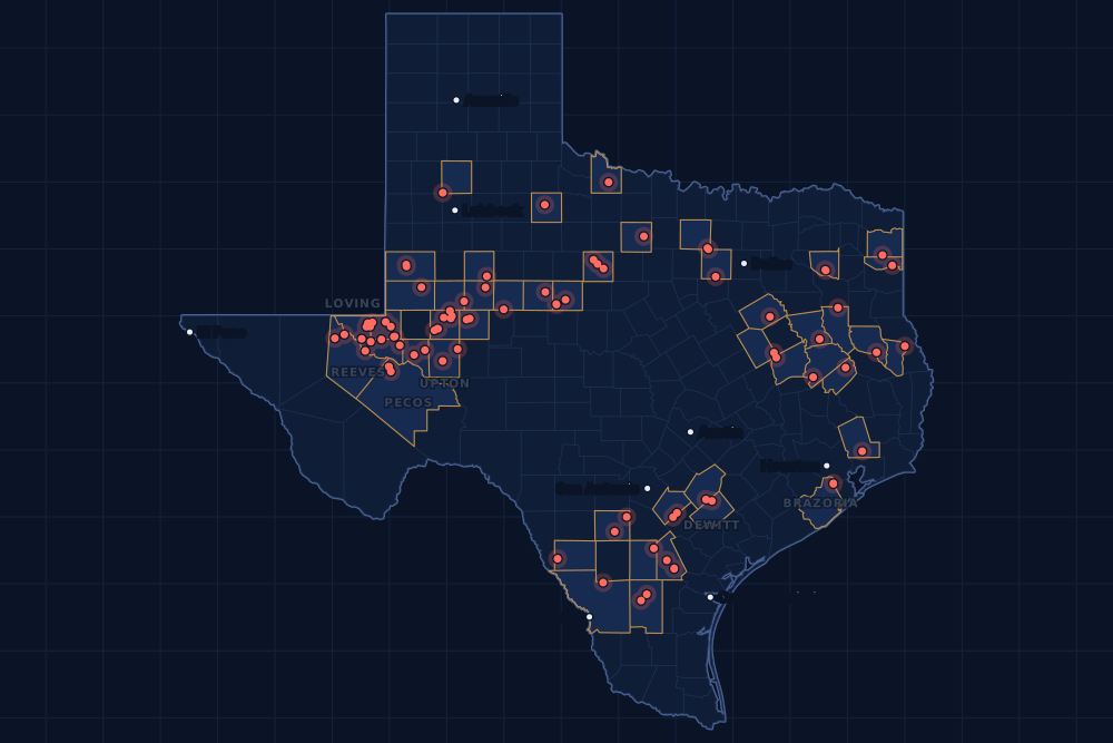
New Texas drilling permits, Jun 22–28, 2026
- 175permits issued
- 122horizontal
- 47counties
- 61operators
That week
Where the state permitted wells
Counties and operators
Who drills, and where
Each county links to its Well Watch page, with its own map and every permit of the last two years. Each operator links to its page.
By county
- 1Midland County41
- 2Ward County12
- 3Loving County10
- 4Upton County8
- 5Brazoria County7
- 6De Witt County7
- 7Pecos County7
- 8Crane County6
- 9Glasscock County6
- 10Winkler County6
- 11Reeves County5
- 12Howard County3
- 13Live Oak County3
- 14McMullen County3
- 15San Augustine County3
And 32 more counties with fewer, in the list below.
By operator
- 1Pioneer Natural Res. USA, Inc.29
- 2Cog Operating LLC9
- 3Waterbridge Stateline LLC8
- 4Denbury Onshore, LLC7
- 5Devon Energy Production Co, L.P.7
- 6Admiral Permian Operating LLC5
- 7Continental Resources, Inc.5
- 8Summit Petroleum LLC5
- 9Apache Corporation4
- 10Blackbeard Operating, LLC4
- 11Civitas Permian Operating, LLC4
- 12Halcon Operating Co., Inc.4
- 13OXY USA Inc.4
- 14Ring Energy, Inc.4
- 15Anadarko E&P Onshore LLC3
And 46 more operators with fewer.
Register · June 22–28, 2026
Every permit, newest first
As the state files them: the lease and well, the operator, the kind of permit and the depth. “On the map” opens the county's live map at the well's spot.
Friday, June 2658 permits
- Anderson CountyFitzgerald, well 19Trueblood Resources, Inc. · new drill · vertical · 670 ftPermit 0916698 · API 42-001-32875On the map
- Andrews CountyUl Venetian, well 1Sabalo II Operating, LLC · new drill · vertical · 12,900 ftPermit 0916697 · API 42-003-49355On the map
- Borden CountyGriffin 64 SWD, well 2Highpeak Energy Holdings, LLC · new drill · vertical · 7,900 ftPermit 0916674 · API 42-033-32849On the map
- De Witt CountyMuir E-Muir D Sa A, well 1HDevon Energy Production Co, L.P. · new drill · horizontal · 14,000 ftPermit 0916628 · API 42-123-35809On the map
- Duval CountyMobil Fee, well 5Safari Production Company, Inc. · recompletion · vertical · 16,300 ftPermit 0916672 · API 42-131-38234On the map
- Frio CountyJosey Wales, well C211VWFormentera Operations LLC · new drill · vertical · 5,900 ftPermit 0916732 · API 42-163-34430On the map
- Gaines CountySeminole San Andres Unit, well 5001ROXY USA Inc. · new drill · vertical · 6,000 ftPermit 0916655 · API 42-165-39029On the map
- Gaines CountySeminole San Andres Unit, well 3206ROXY USA Inc. · new drill · vertical · 6,000 ftPermit 0916654 · API 42-165-39028On the map
- Liberty CountyLaporte Land Company, well 2Veracity Energy LLC · new drill · vertical · 12,500 ftPermit 0915685 · API 42-291-32977On the map
- Limestone CountyW. O. Stone Gas Unit No. 1, well 17Hilcorp Energy Company · recompletion · vertical · 13,950 ftPermit 0916743 · API 42-293-31790On the map
- Live Oak CountyRichey, well 1Aurora Resources Corporation · re-entry · vertical · 4,900 ftPermit 0916671 · API 42-297-33718On the map
- Loving CountyFpw SWD, well 18Waterbridge Stateline LLC · new drill · vertical · 9,000 ftPermit 0916716 · API 42-301-37920On the map
- Loving CountyFpw SWD, well 11Waterbridge Stateline LLC · new drill · vertical · 9,000 ftPermit 0916715 · API 42-301-37919On the map
- Midland CountyBuchanan-King D17L, well 12HPioneer Natural Res. USA, Inc. · new drill · horizontal · 10,442 ftPermit 0916372 · API 42-329-48466On the map
- Midland CountyBuchanan-King D17K, well 11HPioneer Natural Res. USA, Inc. · new drill · horizontal · 10,442 ftPermit 0916370 · API 42-329-48465On the map
- Midland CountyBuchanan-King D17J, well 10HPioneer Natural Res. USA, Inc. · new drill · horizontal · 10,442 ftPermit 0916368 · API 42-329-48464On the map
- Midland CountyBuchanan-King D17I, well 9HPioneer Natural Res. USA, Inc. · new drill · horizontal · 10,442 ftPermit 0916365 · API 42-329-48462On the map
- Midland CountyBuchanan-King D17H, well 8HPioneer Natural Res. USA, Inc. · new drill · horizontal · 10,442 ftPermit 0916363 · API 42-329-48463On the map
- Midland CountyBuchanan-King D17G, well 7HPioneer Natural Res. USA, Inc. · new drill · horizontal · 10,442 ftPermit 0916362 · API 42-329-48461On the map
- Midland CountyBuchanan-King D17F, well 6HPioneer Natural Res. USA, Inc. · new drill · horizontal · 10,442 ftPermit 0916361 · API 42-329-48460On the map
- Midland CountyBob, well 9HJApache Corporation · new drill · horizontal · 12,000 ftPermit 0916007 · API 42-329-48422On the map
- Midland CountyMcalister-Raggett 29K, well 11HPioneer Natural Res. USA, Inc. · new drill · horizontal · 10,406 ftPermit 0916000 · API 42-329-48418On the map
- Midland CountyMcalister-Raggett 29J, well 10HPioneer Natural Res. USA, Inc. · new drill · horizontal · 10,406 ftPermit 0915999 · API 42-329-48417On the map
- Midland CountyMcalister-Raggett 29I, well 9HPioneer Natural Res. USA, Inc. · new drill · horizontal · 10,406 ftPermit 0915998 · API 42-329-48416On the map
- Midland CountyMcalister-Raggett 29H, well 8HPioneer Natural Res. USA, Inc. · new drill · horizontal · 10,406 ftPermit 0915997 · API 42-329-48415On the map
- Midland CountyMcalister-Raggett 29E, well 5HPioneer Natural Res. USA, Inc. · new drill · horizontal · 10,406 ftPermit 0915996 · API 42-329-48414On the map
- Midland CountyMcalister-Raggett 29D, well 4HPioneer Natural Res. USA, Inc. · new drill · horizontal · 10,406 ftPermit 0915995 · API 42-329-48413On the map
- Midland CountyMcalister-Raggett 29C, well 3HPioneer Natural Res. USA, Inc. · new drill · horizontal · 10,406 ftPermit 0915994 · API 42-329-48412On the map
- Midland CountyMcalister-Raggett 29B, well 2HPioneer Natural Res. USA, Inc. · new drill · horizontal · 10,406 ftPermit 0915992 · API 42-329-48411On the map
- Midland CountyMcalister-Raggett 29A, well 1HPioneer Natural Res. USA, Inc. · new drill · horizontal · 10,406 ftPermit 0915991 · API 42-329-48410On the map
- Midland CountyGolladay-Mcalister 51F, well 6HPioneer Natural Res. USA, Inc. · new drill · horizontal · 10,391 ftPermit 0915958 · API 42-329-45569On the map
- Midland CountyFasken-Buchanan 51K, well 11HPioneer Natural Res. USA, Inc. · new drill · horizontal · 10,373 ftPermit 0915876 · API 42-329-45571On the map
- Mitchell CountySpade 18, well 3601Kek Exploration LLC · new drill · vertical · 8,900 ftPermit 0916708 · API 42-335-36125On the map
- Nacogdoches CountyMagellan, well 2Sonerra Resources Corporation · new drill · vertical · 550 ftPermit 0916620 · API 42-347-33552On the map
- Nolan CountyJoe Young, well 3Scout Energy Management LLC · recompletion · vertical · 5,900 ftPermit 0916673 · API 42-353-33014On the map
- Pecos CountyPapershell State Unit, well 3405HContinental Resources, Inc. · new drill · horizontal · 14,040 ftPermit 0916663 · API 42-371-40558On the map
- Pecos CountyPapershell State Unit, well 3404HContinental Resources, Inc. · new drill · horizontal · 14,040 ftPermit 0916662 · API 42-371-40557On the map
- Pecos CountyPapershell State Unit, well 3403HContinental Resources, Inc. · new drill · horizontal · 14,040 ftPermit 0916661 · API 42-371-40556On the map
- Pecos CountyPapershell State Unit, well 3402HContinental Resources, Inc. · new drill · horizontal · 14,040 ftPermit 0916660 · API 42-371-40555On the map
- Pecos CountyPapershell State Unit, well 3401HContinental Resources, Inc. · new drill · horizontal · 14,040 ftPermit 0916658 · API 42-371-40554On the map
- Shackelford CountySimpson, well 5Stasney Well Service, LLC · new drill · vertical · 990 ftPermit 0916675 · API 42-417-39839On the map
- Taylor CountyKissell Unit, well 36L.c.s. Production Company · new drill · vertical · 4,999 ftPermit 0916649 · API 42-441-34739On the map
- Upton CountyPembrook Unit, well 1718HPioneer Natural Res. USA, Inc. · new drill · horizontal · 8,396 ftPermit 0916720 · API 42-461-43711On the map
- Upton CountyPembrook Unit, well 1717HPioneer Natural Res. USA, Inc. · new drill · horizontal · 8,396 ftPermit 0916719 · API 42-461-43710On the map
- Upton CountyPembrook Unit, well 1715HPioneer Natural Res. USA, Inc. · new drill · horizontal · 8,396 ftPermit 0916717 · API 42-461-43709On the map
- Upton CountyMary Lou 3, well 06DNSummit Petroleum LLC · new drill · horizontal · 8,100 ftPermit 0916578 · API 42-461-43699On the map
- Upton CountyMary Lou 2, well 04JMSummit Petroleum LLC · new drill · horizontal · 7,700 ftPermit 0916573 · API 42-461-43698On the map
- Ward CountyEdwards C.w. Et Al, well 16Pitts Energy Co. · recompletion · vertical · 5,530 ftPermit 0916726 · API 42-475-32420On the map
- Wilbarger CountyWaggoner Dn, well 21Burk Royalty Co., Ltd. · recompletion · vertical · 2,000 ftPermit 0916618 · API 42-487-33032On the map
- Wilson CountyDieter C, well 2HWarwick-Artemis, LLC · new drill · horizontal · 8,700 ftPermit 0916735 · API 42-493-33038On the map
- Wilson CountyCoffee Can, well 6HWarwick-Artemis, LLC · new drill · horizontal · 9,300 ftPermit 0916609 · API 42-493-33036On the map
- Wilson CountyDonny, well 5HWarwick-Artemis, LLC · new drill · horizontal · 9,300 ftPermit 0916606 · API 42-493-33035On the map
- Winkler CountyBarque S, well 709HBlackbeard Operating, LLC · new drill · horizontal · 14,000 ftPermit 0916670 · API 42-495-35201On the map
- Winkler CountyBaird, W. E., well 1206Basin Oil & Gas Operating, LLC · new drill · vertical · 6,700 ftPermit 0916668 · API 42-495-35198On the map
- Winkler CountyShield Maiden 54-55, well 353HBlackbeard Operating, LLC · new drill · horizontal · 7,999 ftPermit 0916584 · API 42-495-35197On the map
- Wise CountyVinson Fee B 6 (Aw), well 6HBKV North Texas, LLC · new drill · horizontal · 11,603 ftPermit 0916479 · API 42-497-38161On the map
- Wood CountySasi Ranch Unit, well 4STMontare Operating, Ltd. · recompletion · vertical · 11,300 ftPermit 0916761 · API 42-499-32100On the map
- Wood CountySasi Ranch Unit, well 2XTMontare Operating, Ltd. · recompletion · vertical · 10,100 ftPermit 0916759 · API 42-499-31785On the map
Thursday, June 2524 permits
- Crane CountyUl West Basin 22501 K 21-16-9, well 15HBTA Oil Producers, LLC · new drill · horizontal · 10,400 ftPermit 0916644 · API 42-103-37823On the map
- Crane CountyUl West Basin 22501 L 21-16-9, well 16HBTA Oil Producers, LLC · new drill · horizontal · 10,400 ftPermit 0916611 · API 42-103-37822On the map
- De Witt CountyMuir C, well 6HDevon Energy Production Co, L.P. · new drill · horizontal · 14,000 ftPermit 0916626 · API 42-123-35808On the map
- De Witt CountyMuir C, well 5HDevon Energy Production Co, L.P. · new drill · horizontal · 14,000 ftPermit 0916625 · API 42-123-35807On the map
- De Witt CountyMuir B, well 8HDevon Energy Production Co, L.P. · new drill · horizontal · 14,000 ftPermit 0916624 · API 42-123-35806On the map
- De Witt CountyMuir B, well 7HDevon Energy Production Co, L.P. · new drill · horizontal · 14,000 ftPermit 0916623 · API 42-123-35805On the map
- De Witt CountyMuir B, well 5HDevon Energy Production Co, L.P. · new drill · horizontal · 14,000 ftPermit 0916622 · API 42-123-35804On the map
- De Witt CountyMuir B, well 4HDevon Energy Production Co, L.P. · new drill · horizontal · 14,000 ftPermit 0916621 · API 42-123-35803On the map
- Dimmit CountyRed Ranch Efs, well 34HAtlas Operating LLC · new drill · horizontal · 6,000 ftPermit 0916639 · API 42-127-39205On the map
- Dimmit CountyRed Ranch Efs, well 33HAtlas Operating LLC · new drill · horizontal · 6,000 ftPermit 0916638 · API 42-127-39204On the map
- Glasscock CountyPowell 1031SP, well 2HOXY USA Inc. · new drill · horizontal · 12,000 ftPermit 0915942 · API 42-173-39564On the map
- Glasscock CountyPowell 1041DP, well 3HOXY USA Inc. · new drill · horizontal · 12,000 ftPermit 0915939 · API 42-173-39563On the map
- Gonzales CountyBarnhart (Ef)-Jm Pres Sa, well 512HMarathon Oil Ef LLC · new drill · horizontal · 17,500 ftPermit 0916582 · API 42-177-34842On the map
- Howard CountyEngle Unit B 43-54, well 3AHSurge Operating, LLC · new drill · horizontal · 9,000 ftPermit 0916651 · API 42-227-42900On the map
- Midland CountyBob, well U 6HSApache Corporation · new drill · horizontal · 12,000 ftPermit 0915985 · API 42-329-48421On the map
- Midland CountyBob, well 3HMApache Corporation · new drill · horizontal · 12,000 ftPermit 0915981 · API 42-329-48420On the map
- Midland CountyBob, well 2HMApache Corporation · new drill · horizontal · 12,000 ftPermit 0915978 · API 42-329-48419On the map
- Midland CountyFasken-Buchanan 51J, well 10HPioneer Natural Res. USA, Inc. · new drill · horizontal · 10,373 ftPermit 0915877 · API 42-329-45570On the map
- Pecos CountySisters State Neal Lethco B, well 2HSwordfish Energy Operating, LLC · new drill · horizontal · 9,500 ftPermit 0916657 · API 42-371-40553On the map
- Pecos CountySisters State Neal Lethco A, well 1HSwordfish Energy Operating, LLC · new drill · horizontal · 9,750 ftPermit 0916656 · API 42-371-40552On the map
- Reeves CountyRalphie 7 Unit, well 7UHJetta Operating Company, Inc. · new drill · horizontal · 11,450 ftPermit 0916484 · API 42-389-42183On the map
- Tarrant CountyLewisville '7' Unit, well 1HBKV North Texas, LLC · recompletion · horizontal · 8,880 ftPermit 0916612 · API 42-439-31434On the map
- Ward CountyGarfield C, well 8908HHalcon Operating Co., Inc. · new drill · horizontal · 13,000 ftPermit 0916667 · API 42-475-39089On the map
- Ward CountyGarfield B, well 8907HHalcon Operating Co., Inc. · new drill · horizontal · 13,000 ftPermit 0916666 · API 42-475-39088On the map
Wednesday, June 2441 permits
- Crane CountyLea, P.j. Et Al, well 4022JHRing Energy, Inc. · new drill · horizontal · 3,675 ftPermit 0916594 · API 42-103-37821On the map
- Crane CountyLea, P.j. Et Al, well 4023MHRing Energy, Inc. · new drill · horizontal · 4,000 ftPermit 0916593 · API 42-103-37820On the map
- Crane CountyLea, P.j. Et Al, well 4024THRing Energy, Inc. · new drill · horizontal · 5,025 ftPermit 0916592 · API 42-103-37819On the map
- Crane CountyLea, P.j. Et Al, well 4028THRing Energy, Inc. · new drill · horizontal · 5,020 ftPermit 0916591 · API 42-103-37818On the map
- Duval CountyBlackhawk, well 1Cimarron Engineering, LLC · new drill · vertical · 3,450 ftPermit 0916616 · API 42-131-39703On the map
- Frio CountyBordovsky J S 'A', well 192ACentral Gulf Petroleum Inc · new drill · vertical · 3,800 ftPermit 0915772 · API 42-163-34429On the map
- Gonzales CountyBarnhart (Ef) K-Jm Pres Sa, well 511HMarathon Oil Ef LLC · new drill · horizontal · 17,500 ftPermit 0916581 · API 42-177-34843On the map
- Howard CountyEngle Unit B 43-54, well 4SHSurge Operating, LLC · new drill · horizontal · 9,000 ftPermit 0916652 · API 42-227-42901On the map
- Howard CountyEngle Unit A 43-54, well 3SHSurge Operating, LLC · new drill · horizontal · 9,000 ftPermit 0916642 · API 42-227-42902On the map
- Live Oak CountyBennett, well 1Cimarron Engineering, LLC · new drill · vertical · 8,200 ftPermit 0916614 · API 42-297-36583On the map
- Loving CountyFpw SWD, well 8Waterbridge Stateline LLC · new drill · vertical · 9,000 ftPermit 0916681 · API 42-301-37918On the map
- Loving CountyAermotor SWD, well 7Waterbridge Stateline LLC · new drill · vertical · 9,000 ftPermit 0916680 · API 42-301-36564On the map
- Loving CountyFpw SWD, well 9Waterbridge Stateline LLC · new drill · vertical · 9,000 ftPermit 0916679 · API 42-301-37917On the map
- Loving CountyAermotor SWD, well 8Waterbridge Stateline LLC · new drill · vertical · 9,000 ftPermit 0916678 · API 42-301-36565On the map
- Loving CountyFpw SWD, well 21Waterbridge Stateline LLC · new drill · vertical · 9,000 ftPermit 0916677 · API 42-301-37916On the map
- Midland CountyBulldog B, well H135NBPermian Deep Rock Oil Co., LLC · new drill · horizontal · 12,000 ftPermit 0916340 · API 42-329-48458On the map
- Midland CountyFasken-Buchanan 51I, well 9HPioneer Natural Res. USA, Inc. · new drill · horizontal · 10,373 ftPermit 0915883 · API 42-329-45577On the map
- Midland CountyFasken-Buchanan 51H, well 8HPioneer Natural Res. USA, Inc. · new drill · horizontal · 10,373 ftPermit 0915882 · API 42-329-45576On the map
- Midland CountyFasken-Buchanan 51C, well 3HPioneer Natural Res. USA, Inc. · new drill · horizontal · 10,373 ftPermit 0915881 · API 42-329-45575On the map
- Midland CountyFasken-Buchanan 51N, well 14HPioneer Natural Res. USA, Inc. · new drill · horizontal · 10,373 ftPermit 0915880 · API 42-329-45574On the map
- Midland CountyFasken-Buchanan 51M, well 13HPioneer Natural Res. USA, Inc. · new drill · horizontal · 10,373 ftPermit 0915879 · API 42-329-45568On the map
- Midland CountyFasken-Buchanan 51L, well 12HPioneer Natural Res. USA, Inc. · new drill · horizontal · 10,373 ftPermit 0915878 · API 42-329-45572On the map
- Midland CountyGolladay-Buchanan 51I, well 109HPioneer Natural Res. USA, Inc. · new drill · horizontal · 10,370 ftPermit 0915846 · API 42-329-48398On the map
- Reeves CountyWyvern State 57-3-39 Unit, well 3AHU.S. Energy Development Corp · new drill · horizontal · 12,447 ftPermit 0916650 · API 42-389-42190On the map
- Reeves CountyWyvern State 57-3-39 Unit, well 2AHU.S. Energy Development Corp · new drill · horizontal · 12,447 ftPermit 0916648 · API 42-389-42189On the map
- Reeves CountyWyvern State 57-3-39 Unit, well 1BHU.S. Energy Development Corp · new drill · horizontal · 12,447 ftPermit 0916647 · API 42-389-42188On the map
- Reeves CountyRalphie 7 Unit, well 8HJetta Operating Company, Inc. · new drill · horizontal · 11,450 ftPermit 0916483 · API 42-389-42182On the map
- San Augustine CountyBsm North Unit, well 3HBRockcliff Energy Operating III · new drill · horizontal · 16,000 ftPermit 0916565 · API 42-405-30973On the map
- San Augustine CountyBsm North Unit, well 2HRockcliff Energy Operating III · new drill · horizontal · 16,000 ftPermit 0916564 · API 42-405-30972On the map
- San Augustine CountyBsm North Unit, well 1HBRockcliff Energy Operating III · new drill · horizontal · 16,000 ftPermit 0916563 · API 42-405-30971On the map
- Upton CountyMary Lou 11, well 22DNSummit Petroleum LLC · new drill · horizontal · 8,100 ftPermit 0916488 · API 42-461-43703On the map
- Upton CountyMary Lou 10, well 20BUSummit Petroleum LLC · new drill · horizontal · 8,600 ftPermit 0916486 · API 42-461-43702On the map
- Upton CountyMary Lou 9, well 18BLSummit Petroleum LLC · new drill · horizontal · 9,200 ftPermit 0916485 · API 42-461-43693No location yet
- Ward CountyUl Good Bull, well 301BCAdmiral Permian Operating LLC · new drill · horizontal · 11,500 ftPermit 0916603 · API 42-475-39086On the map
- Ward CountyUl Good Bull, well 201SHAdmiral Permian Operating LLC · new drill · horizontal · 10,000 ftPermit 0916602 · API 42-475-39085On the map
- Ward CountyUl Good Bull, well 1WCAdmiral Permian Operating LLC · new drill · horizontal · 12,500 ftPermit 0916601 · API 42-475-39084On the map
- Ward CountyUl Good Bull, well 1WBAdmiral Permian Operating LLC · new drill · horizontal · 12,500 ftPermit 0916600 · API 42-475-39083On the map
- Ward CountyUl Good Bull, well 1WAAdmiral Permian Operating LLC · new drill · horizontal · 10,500 ftPermit 0916598 · API 42-475-39081On the map
- Ward CountyGarfield A, well 8906HHalcon Operating Co., Inc. · new drill · horizontal · 13,000 ftPermit 0916493 · API 42-475-39087On the map
- Winkler CountyAermotor SWD, well 12Waterbridge Stateline LLC · new drill · vertical · 9,000 ftPermit 0916676 · API 42-495-34922On the map
- Wood CountySchneider (Buda) Unit, well 5Montare Operating, Ltd. · recompletion · vertical · 8,983 ftPermit 0915718 · API 42-499-31712On the map
Tuesday, June 2312 permits
- Cherokee CountyBarnes 3, well 1Faulconer Energy, LLC · recompletion · vertical · 12,315 ftPermit 0916574 · API 42-073-31151On the map
- Hale CountyAnton-Irish Clearfork Unit, well 299Occidental Permian Ltd. · recompletion · vertical · 6,000 ftPermit 0916589 · API 42-189-30070On the map
- Hale CountyAnton-Irish Clearfork Unit, well 295Occidental Permian Ltd. · recompletion · vertical · 6,000 ftPermit 0916588 · API 42-189-30062On the map
- Leon CountyGail King, well 41Hilcorp Energy Company · recompletion · vertical · 15,570 ftPermit 0916640 · API 42-289-31796On the map
- Martin CountyWrs Hesperaloe G, well 2HDOxyrock Operating, LLC · new drill · horizontal · 12,000 ftPermit 0916218 · API 42-317-47329On the map
- McMullen CountyJellicoe, well C 3HVerdun Oil & Gas LLC · new drill · horizontal · 11,948 ftPermit 0916597 · API 42-311-37697On the map
- McMullen CountyJellicoe, well B 2HVerdun Oil & Gas LLC · new drill · horizontal · 12,149 ftPermit 0916596 · API 42-311-37696On the map
- McMullen CountyJellicoe, well A 1HVerdun Oil & Gas LLC · new drill · horizontal · 12,152 ftPermit 0916595 · API 42-311-37695On the map
- Navarro CountyRLS08 Jc Nolan 12'', well 1Energy Transfer Company · new drill · vertical · 400 ftPermit 0916532 · API 42-349-35068On the map
- Taylor CountyKissell, well 7WIL.c.s. Production Company · new drill · vertical · 4,999 ftPermit 0916645 · API 42-441-34695On the map
- Ward CountyGarfield, well 8905HHalcon Operating Co., Inc. · new drill · horizontal · 13,000 ftPermit 0916375 · API 42-475-39079On the map
- Wise CountyWilson, Jack Gu, well 6HBKV Barnett, LLC · recompletion · horizontal · 8,800 ftPermit 0916436 · API 42-497-36063On the map
Monday, June 2240 permits
- Brazoria CountyWest Hastings Unit, well 6938Denbury Onshore, LLC · new drill · vertical · 6,380 ftPermit 0916580 · API 42-039-33394On the map
- Brazoria CountyWest Hastings Unit, well 6519Denbury Onshore, LLC · new drill · vertical · 6,380 ftPermit 0916506 · API 42-039-33393On the map
- Brazoria CountyWest Hastings Unit, well 8140Denbury Onshore, LLC · new drill · vertical · 6,314 ftPermit 0916505 · API 42-039-33392On the map
- Brazoria CountyWest Hastings Unit, well 7929Denbury Onshore, LLC · new drill · vertical · 6,380 ftPermit 0916504 · API 42-039-33391On the map
- Brazoria CountyWest Hastings Unit, well 8210Denbury Onshore, LLC · new drill · vertical · 6,380 ftPermit 0916503 · API 42-039-33390On the map
- Brazoria CountyWest Hastings Unit, well 6939Denbury Onshore, LLC · new drill · vertical · 6,380 ftPermit 0916501 · API 42-039-33389On the map
- Brazoria CountyWest Hastings Unit, well 7712Denbury Onshore, LLC · new drill · vertical · 6,380 ftPermit 0916499 · API 42-039-33388On the map
- Cass CountyLynn, well 1HRose City Resources, LLC · new drill · horizontal · 13,000 ftPermit 0915467 · API 42-067-30979On the map
- Glasscock CountyPacific B, well 312HCivitas Permian Operating, LLC · new drill · horizontal · 10,670 ftPermit 0916523 · API 42-173-39585On the map
- Glasscock CountyPacific A, well 311HCivitas Permian Operating, LLC · new drill · horizontal · 10,650 ftPermit 0916518 · API 42-173-39584On the map
- Glasscock CountyBandon B, well 212HCivitas Permian Operating, LLC · new drill · horizontal · 10,600 ftPermit 0916515 · API 42-173-39583On the map
- Glasscock CountyBandon A, well 311HCivitas Permian Operating, LLC · new drill · horizontal · 10,500 ftPermit 0916513 · API 42-173-39582On the map
- Houston CountyButler-Maples D Unit, well 101Empire Texas Operating LLC · recompletion · vertical · 18,000 ftPermit 0916528 · API 42-225-31336On the map
- King CountyBoc 'A', well 1Geosurveys, Inc. · new drill · vertical · 6,200 ftPermit 0916338 · API 42-269-33072On the map
- Live Oak CountyC N Freeman, well 8Aurora Resources Corporation · new drill · vertical · 5,000 ftPermit 0916537 · API 42-297-36582On the map
- Loving CountyMichelada 1-0-45-66 G, well 63HAnadarko E&P Onshore LLC · new drill · horizontal · 12,000 ftPermit 0916571 · API 42-301-37909On the map
- Loving CountyMichelada 1-0-45-66 F, well 54HAnadarko E&P Onshore LLC · new drill · horizontal · 12,000 ftPermit 0916570 · API 42-301-37908On the map
- Loving CountyMichelada 1-0-45-66 A, well 61HAnadarko E&P Onshore LLC · new drill · horizontal · 12,000 ftPermit 0916566 · API 42-301-37902On the map
- Marion CountyTrash Pandas (Aw), well 1HRfe Operating, LLC · new drill · horizontal · 9,700 ftPermit 0916520 · API 42-315-31077On the map
- Midland CountyRebel, well H115NBPermian Deep Rock Oil Co., LLC · new drill · horizontal · 12,000 ftPermit 0916548 · API 42-329-48468On the map
- Midland CountyCountry Mac A14, well 706MHCog Operating LLC · new drill · horizontal · 10,000 ftPermit 0915576 · API 42-329-48373On the map
- Midland CountyCountry Mac A13, well 705LHCog Operating LLC · new drill · horizontal · 10,000 ftPermit 0915575 · API 42-329-48372On the map
- Midland CountyCountry Mac A12, well 705MHCog Operating LLC · new drill · horizontal · 10,000 ftPermit 0915574 · API 42-329-48371On the map
- Midland CountyCountry Mac A11, well 703BHCog Operating LLC · new drill · horizontal · 10,000 ftPermit 0915573 · API 42-329-48370On the map
- Midland CountyCountry Mac A5, well 702LHCog Operating LLC · new drill · horizontal · 10,000 ftPermit 0915567 · API 42-329-48364On the map
- Midland CountyCountry Mac A4, well 702MHCog Operating LLC · new drill · horizontal · 10,000 ftPermit 0915566 · API 42-329-48363On the map
- Midland CountyCountry Mac A3, well 701LHCog Operating LLC · new drill · horizontal · 10,000 ftPermit 0915565 · API 42-329-48362On the map
- Midland CountyCountry Mac A2, well 701MHCog Operating LLC · new drill · horizontal · 10,000 ftPermit 0915564 · API 42-329-48361On the map
- Midland CountyCountry Mac A1, well 701BHCog Operating LLC · new drill · horizontal · 10,000 ftPermit 0915563 · API 42-329-48360On the map
- Shackelford CountyCook Ranch '60S', well 19Stasney Well Service, LLC · recompletion · vertical · 2,000 ftPermit 0916586 · API 42-417-39491On the map
- Shackelford CountyNail '120', well 4Bluff Creek Petroleum, LLC · new drill · vertical · 1,999 ftPermit 0916577 · API 42-417-39838On the map
- Taylor CountyForrest-Kennedy, well 1VX Operating, LLC · new drill · vertical · 4,999 ftPermit 0916444 · API 42-441-34737On the map
- Trinity CountyDue, well 1Walker Operating Company · new drill · vertical · 1,800 ftPermit 0916438 · API 42-455-30533On the map
- Ward CountyJake 201-200 Unit, well 223HRPermian Resources Operating, LLC · new drill · horizontal · 13,000 ftPermit 0916576 · API 42-475-39082On the map
- Ward CountyDavis 201-200-199 Unit, well 222HRPermian Resources Operating, LLC · new drill · horizontal · 13,000 ftPermit 0916575 · API 42-475-39080On the map
- Webb CountyCox E, well 500HEOG Resources, Inc. · new drill · horizontal · 14,700 ftPermit 0916585 · API 42-479-45664On the map
- Webb CountyCox D, well 121HEOG Resources, Inc. · new drill · horizontal · 14,500 ftPermit 0916583 · API 42-479-45663On the map
- Winkler CountyShield Maiden 54-55, well 352HBlackbeard Operating, LLC · new drill · horizontal · 7,999 ftPermit 0916533 · API 42-495-35195On the map
- Winkler CountyShield Maiden 47-46 6UA, well 348HBlackbeard Operating, LLC · new drill · horizontal · 7,999 ftPermit 0916355 · API 42-495-35194On the map
- Young CountySlater, well 2Borderline Operating Corp. · re-entry · vertical · 3,999 ftPermit 0916590 · API 42-503-05158On the map
Cancelled permits are left out. To look a permit up at the source, use the Railroad Commission's drilling permit query with its permit number.
Archive
Earlier weeks
Each finished week, Monday to Sunday, has its own page that does not change. The feed gets one entry per week.
- Nov 9–15, 2026103
- Nov 2–8, 2026164
- Oct 26 – Nov 1, 2026242
- Oct 19–25, 2026215
- Oct 12–18, 2026147
- Oct 5–11, 2026152
- Sep 28 – Oct 4, 2026156
- Sep 21–27, 2026194
- Sep 14–20, 2026167
- Sep 7–13, 2026133
- Aug 31 – Sep 6, 2026182
- Aug 24–30, 2026118
Every week since January 1, 2024 (150 weeks)
2026
- Aug 17–23167
- Aug 10–16198
- Aug 3–9186
- Jul 27 – Aug 2143
- Jul 20–26170
- Jul 13–19117
- Jul 6–12194
- Jun 29 – Jul 5114
- Jun 22–28175
- Jun 15–21186
- Jun 8–14187
- Jun 1–7154
- May 25–31158
- May 18–24197
- May 11–17182
- May 4–10190
- Apr 27 – May 3156
- Apr 20–26210
- Apr 13–19133
- Apr 6–12206
- Mar 30 – Apr 5129
- Mar 23–29159
- Mar 16–22167
- Mar 9–15166
- Mar 2–8140
- Feb 23 – Mar 1181
- Feb 16–22141
- Feb 9–15133
- Feb 2–8124
- Jan 26 – Feb 1126
- Jan 19–25189
- Jan 12–18280
- Jan 5–11129
2025
- Dec 29 – Jan 4, 202656
- Dec 22–2846
- Dec 15–21154
- Dec 8–14119
- Dec 1–7128
- Nov 24–3061
- Nov 17–23140
- Nov 10–1698
- Nov 3–9107
- Oct 27 – Nov 2137
- Oct 20–26145
- Oct 13–19173
- Oct 6–12206
- Sep 29 – Oct 5124
- Sep 22–28141
- Sep 15–21165
- Sep 8–14127
- Sep 1–7105
- Aug 25–31145
- Aug 18–24115
- Aug 11–17140
- Aug 4–10131
- Jul 28 – Aug 3134
- Jul 21–27151
- Jul 14–20151
- Jul 7–13148
- Jun 30 – Jul 6148
- Jun 23–29167
- Jun 16–22118
- Jun 9–15115
- Jun 2–8147
- May 26 – Jun 190
- May 19–25148
- May 12–18120
- May 5–11114
- Apr 28 – May 4135
- Apr 21–27182
- Apr 14–20115
- Apr 7–13197
- Mar 31 – Apr 6194
- Mar 24–30170
- Mar 17–23189
- Mar 10–16177
- Mar 3–9141
- Feb 24 – Mar 2172
- Feb 17–23145
- Feb 10–16170
- Feb 3–9167
- Jan 27 – Feb 2149
- Jan 20–26158
- Jan 13–19176
- Jan 6–12140
2024
- Dec 30 – Jan 5, 202597
- Dec 23–295
- Dec 16–22168
- Dec 9–15202
- Dec 2–8182
- Nov 25 – Dec 189
- Nov 18–24189
- Nov 11–17145
- Nov 4–10152
- Oct 28 – Nov 3134
- Oct 21–27163
- Oct 14–20147
- Oct 7–13114
- Sep 30 – Oct 6138
- Sep 23–29133
- Sep 16–22175
- Sep 9–15144
- Sep 2–8138
- Aug 26 – Sep 1177
- Aug 19–25207
- Aug 12–18186
- Aug 5–11145
- Jul 29 – Aug 4191
- Jul 22–28174
- Jul 15–21164
- Jul 8–14205
- Jul 1–7106
- Jun 24–30183
- Jun 17–23192
- Jun 10–16161
- Jun 3–9176
- May 27 – Jun 2135
- May 20–26223
- May 13–19169
- May 6–12155
- Apr 29 – May 5191
- Apr 22–28224
- Apr 15–21200
- Apr 8–14157
- Apr 1–7149
- Mar 25–31102
- Mar 18–24130
- Mar 11–17228
- Mar 4–10178
- Feb 26 – Mar 3187
- Feb 19–25164
- Feb 12–18190
- Feb 5–11137
- Jan 29 – Feb 4177
- Jan 22–28172
- Jan 15–21107
- Jan 8–14251
- Jan 1–7148
FAQ
Questions people ask
What is a drilling permit?
Permission from the Railroad Commission of Texas to drill a well, or to re-enter or deepen an old one, at a stated spot and to a stated depth. An operator files for it before the rig comes; it lasts two years. Many permitted wells are drilled within months, some never are.
Is this week complete?
Yes. The state has issued permits on later days, so this week's list is closed. A permit the state cancels later drops off the list.
Some permits are not on the map. Why?
The map draws a permit at the well's surface location as the state files it. A new permit's location can take a few days to reach the state's files; until then it is listed here but not drawn.
Does a new permit near my land mean I will be paid?
No. A permit says where a well may be drilled, not whose minerals it will produce or who is paid. That depends on your lease, the unit the well is pooled in and the division order. If a well is drilled on or next to your tract, watch for a division order from the operator.
Can I get these by email or in a feed?
Yes. The feed on this page has one entry for each finished week, for any feed reader. For one county, an abstract or a lease, Texas Well Watch sends one email a week when the state files something new there; it is free with an account.
Sources
- Railroad Commission of Texas, drilling permit master and trailer, daily file (with latitudes and longitudes)www.rrc.texas.gov/resource-center/research/data-sets-available-for-download/ · loaded every night; newest permit on file November 20, 2026
- Railroad Commission of Texas, drilling permit query (one permit at the source)webapps.rrc.texas.gov/DP/initializePublicQueryAction.do · linked, not read
- US Census Bureau, cartographic boundary files (county lines), through the us-atlas package 3.0.1www.census.gov/geographies/mapping-files/time-series/geo/cartographic-boundary.html · built into the site with its well maps
- GeoNames, towns and their points (CC BY 4.0)www.geonames.org/ · built into the site with its town pages