
Railroad Commission of Texas · week of July 22, 2024
New Texas drilling permits, Jul 22–28, 2024
- 174permits issued
- 132horizontal
- 45counties
- 59operators
That week
Where the state permitted wells
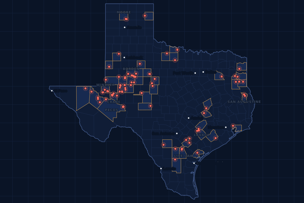
Counties and operators
Who drills, and where
Each county links to its Well Watch page, with its own map and every permit of the last two years. Each operator links to its page.
By county
- 1Midland County44
- 2Winkler County17
- 3Reeves County13
- 4Borden County11
- 5Karnes County11
- 6Crane County9
- 7Live Oak County5
- 8Pecos County5
- 9Lavaca County4
- 10Martin County4
- 11San Augustine County4
- 12Archer County3
- 13Moore County3
- 14Taylor County3
- 15Burleson County2
And 30 more counties with fewer, in the list below.
By operator
- 1Continental Resources, Inc.13
- 2Blackbeard Operating, LLC11
- 3Apache Corporation9
- 4Cog Operating LLC8
- 5Endeavor Energy Resources L.P.7
- 6EOG Resources, Inc.7
- 7Surge Operating, LLC7
- 8Highpeak Energy Holdings, LLC6
- 9Permian Deep Rock Oil Co., LLC6
- 10Pioneer Natural Res. USA, Inc.6
- 11XTO Energy Inc.6
- 12Chevron U. S. A. Inc.5
- 13Kinder Morgan Production Co LLC5
- 14U.S. Energy Development Corp5
- 15Baytex Energy USA, Inc.4
And 44 more operators with fewer.
Register · July 22–28, 2024
Every permit, newest first
As the state files them: the lease and well, the operator, the kind of permit and the depth. “On the map” opens the county's live map at the well's spot.
Friday, July 2664 permits
- Andrews CountyApollo, well 1Bulldog Operating Company · new drill · vertical · 10,425 ftPermit 0901543 · API 42-003-49017On the map
- Borden CountyZilant Unit B 63-87, well 6AHSurge Operating, LLC · new drill · horizontal · 8,500 ftPermit 0901521 · API 42-033-32726On the map
- Borden CountyZilant Unit B 63-87, well 5AHSurge Operating, LLC · new drill · horizontal · 8,500 ftPermit 0901520 · API 42-033-32725On the map
- Borden CountyLuckpot, well 1Halvey Energy, LLC · new drill · vertical · 10,300 ftPermit 0901519 · API 42-033-32728On the map
- Borden CountyZilant Unit B 63-87, well 4AHSurge Operating, LLC · new drill · horizontal · 8,500 ftPermit 0901518 · API 42-033-32724On the map
- Borden CountyJewell 68-6 A Unit, well L 1HHighpeak Energy Holdings, LLC · new drill · horizontal · 5,800 ftPermit 0901417 · API 42-033-32718On the map
- Cass CountyAdams, well 1HRose City Resources, LLC · new drill · horizontal · 13,000 ftPermit 0901448 · API 42-067-30955On the map
- Chambers CountyMont Belvieu Storage, well 602Exxonmobil Pipeline Company LLC · new drill · vertical · 3,470 ftPermit 0901537 · API 42-071-32673On the map
- Crane CountyUniversity -25-, well 1Boaz Energy II Operating, LLC · recompletion · vertical · 11,190 ftPermit 0901509 · API 42-103-33066On the map
- Crane CountyWaddell Tr 1-W, well 201Blackbeard Operating, LLC · recompletion · vertical · 3,490 ftPermit 0901496 · API 42-103-01003On the map
- Duval CountyFoster Heirs 'B', well 5Aurora Resources Corporation · new drill · vertical · 1,600 ftPermit 0901493 · API 42-131-39694On the map
- Fisher CountyBertha 28-6, well 1HBrowning Oil Company, Inc. · new drill · horizontal · 7,500 ftPermit 0901538 · API 42-151-33370On the map
- Frio CountyHarlan Rk, well 16HTrailblazer Energy Resources,llc · new drill · horizontal · 6,490 ftPermit 0901534 · API 42-163-34341On the map
- Frio CountyHarlan Rk, well 15HTrailblazer Energy Resources,llc · new drill · horizontal · 6,480 ftPermit 0901515 · API 42-163-34340On the map
- Gregg CountyCulpepper, well 7Neches Exploration, L.L.C. · recompletion · vertical · 10,799 ftPermit 0901439 · API 42-183-31294On the map
- Hemphill CountyVollmert 'C', well 8Unit Petroleum Company · recompletion · vertical · 8,000 ftPermit 0901552 · API 42-211-34301On the map
- Hockley CountyWeeks A, well 2Seaboard Operating Co. · new drill · vertical · 6,900 ftPermit 0901491 · API 42-219-37535On the map
- Karnes CountyBlondie C, well 3HEOG Resources, Inc. · new drill · horizontal · 10,000 ftPermit 0901528 · API 42-255-38116On the map
- Karnes CountyBlondie B, well 2HEOG Resources, Inc. · new drill · horizontal · 10,000 ftPermit 0901527 · API 42-255-38115On the map
- Karnes CountyBlondie A, well 1HEOG Resources, Inc. · new drill · horizontal · 10,000 ftPermit 0901525 · API 42-255-38114On the map
- Kent CountySalt Creek Field Unit, well D 74WOXY USA WTP LP · recompletion · vertical · 7,000 ftPermit 0901545 · API 42-263-31182On the map
- Lavaca CountyPandora B, well 2HBaytex Energy USA, Inc. · new drill · horizontal · 14,500 ftPermit 0901383 · API 42-285-34293On the map
- Martin CountyMinotaur 38-66 Unit 2, well 2WBEndeavor Energy Resources L.P. · new drill · horizontal · 11,000 ftPermit 0901409 · API 42-317-46346On the map
- Martin CountyMinotaur 38-66 Unit 2, well 2MSEndeavor Energy Resources L.P. · new drill · horizontal · 11,000 ftPermit 0901392 · API 42-317-46338On the map
- Midland CountyTxl 27 Unit 4, well 3475JHXTO Energy Inc. · new drill · horizontal · 10,500 ftPermit 0901529 · API 42-329-47267On the map
- Midland CountyTxl 27 Unit 4, well 3477JHXTO Energy Inc. · new drill · horizontal · 10,500 ftPermit 0901526 · API 42-329-47266On the map
- Midland CountyTxl 27 Unit 4, well 3408BHXTO Energy Inc. · new drill · horizontal · 10,500 ftPermit 0901524 · API 42-329-47265On the map
- Midland CountyTxl 27 Unit 4, well 3419AHXTO Energy Inc. · new drill · horizontal · 10,500 ftPermit 0901523 · API 42-329-47264On the map
- Midland CountyTxl 27 Unit 4, well 3479JHXTO Energy Inc. · new drill · horizontal · 10,500 ftPermit 0901522 · API 42-329-47263On the map
- Midland CountyTxl 27 Unit 3, well 2204BHXTO Energy Inc. · new drill · horizontal · 10,500 ftPermit 0901517 · API 42-329-47262On the map
- Midland CountySoa Scharbauer Se, well 2036USChevron U. S. A. Inc. · new drill · horizontal · 15,000 ftPermit 0901435 · API 42-329-47273On the map
- Midland CountySoa Scharbauer Se, well 2035USChevron U. S. A. Inc. · new drill · horizontal · 15,000 ftPermit 0901434 · API 42-329-47272On the map
- Midland CountySoa Scharbauer Se, well 2034USChevron U. S. A. Inc. · new drill · horizontal · 15,000 ftPermit 0901433 · API 42-329-47271On the map
- Midland CountyYellow Belly, well 16HSApache Corporation · new drill · horizontal · 12,000 ftPermit 0901282 · API 42-329-47245On the map
- Midland CountyYellow Belly, well 6HSApache Corporation · new drill · horizontal · 12,000 ftPermit 0901281 · API 42-329-47244On the map
- Midland CountyYellow Belly, well 15HJApache Corporation · new drill · horizontal · 12,000 ftPermit 0901280 · API 42-329-47243On the map
- Midland CountyYellow Belly, well 5HSApache Corporation · new drill · horizontal · 12,000 ftPermit 0901279 · API 42-329-47239On the map
- Midland CountyYellow Belly, well 14HSApache Corporation · new drill · horizontal · 12,000 ftPermit 0901278 · API 42-329-47238On the map
- Midland CountyYellow Belly, well 4HSApache Corporation · new drill · horizontal · 12,000 ftPermit 0901277 · API 42-329-47236On the map
- Midland CountyYellow Belly, well 13HJApache Corporation · new drill · horizontal · 12,000 ftPermit 0901276 · API 42-329-47235On the map
- Midland CountyYellow Belly, well 12HSApache Corporation · new drill · horizontal · 12,000 ftPermit 0901275 · API 42-329-47232On the map
- Midland CountyYellow Belly, well 3HSApache Corporation · new drill · horizontal · 12,000 ftPermit 0901274 · API 42-329-47231On the map
- Moore CountyRead, well 1AScout Energy Management LLC · recompletion · horizontal · 3,151 ftPermit 0901488 · API 42-341-33533On the map
- Panola CountyBeckworth, well 2Sheridan Production Co III, LLC · recompletion · vertical · 9,750 ftPermit 0901516 · API 42-365-32332On the map
- Pecos CountyYates Field Unit, well 39B17Kinder Morgan Production Co LLC · recompletion · horizontal · 1,999 ftPermit 0901547 · API 42-371-07391On the map
- Pecos CountyYates Field Unit, well 275Z50Kinder Morgan Production Co LLC · recompletion · horizontal · 1,999 ftPermit 0901535 · API 42-371-35000On the map
- Pecos CountyYates Field Unit, well 47C26Kinder Morgan Production Co LLC · recompletion · horizontal · 1,999 ftPermit 0901497 · API 42-371-36059On the map
- Pecos CountyYates Field Unit, well 53G12Kinder Morgan Production Co LLC · recompletion · horizontal · 1,999 ftPermit 0901494 · API 42-371-35836On the map
- Reeves CountyHackberry Springs, well 2THU.S. Energy Development Corp · new drill · horizontal · 12,000 ftPermit 0901468 · API 42-389-41296On the map
- Reeves CountyHackberry Springs, well 5THU.S. Energy Development Corp · new drill · horizontal · 12,000 ftPermit 0901467 · API 42-389-41295On the map
- Reeves CountyHackberry Springs, well 4AHU.S. Energy Development Corp · new drill · horizontal · 12,000 ftPermit 0901466 · API 42-389-41294On the map
- Reeves CountyHackberry Springs, well 3BHU.S. Energy Development Corp · new drill · horizontal · 12,000 ftPermit 0901465 · API 42-389-41293On the map
- Reeves CountyHackberry Springs, well 1BHU.S. Energy Development Corp · new drill · horizontal · 12,000 ftPermit 0901464 · API 42-389-41292On the map
- Refugio CountyLambert, M.f., well 144Hilcorp Energy Company · recompletion · vertical · 4,535 ftPermit 0901450 · API 42-391-31289On the map
- Robertson CountyRing A, well 1HAWildfire Energy Operating LLC · new drill · horizontal · 7,500 ftPermit 0901507 · API 42-395-32103On the map
- Scurry CountyLion Diamond 'M' Unit, well J 5BKinder Morgan Production Co LLC · new drill · vertical · 7,800 ftPermit 0901101 · API 42-415-30624On the map
- Taylor CountySchneider, well 21WIL.c.s. Production Company · new drill · vertical · 4,999 ftPermit 0901533 · API 42-441-34709On the map
- Van Zandt CountyBracken, J. A. 35, well 10Basa Resources, Inc. · recompletion · vertical · 3,012 ftPermit 0901477 · API 42-467-30618On the map
- Winkler CountyUniversity 45 A, well 7Jetta Operating Company, Inc. · recompletion · vertical · 7,250 ftPermit 0901469 · API 42-495-32643On the map
- Winkler CountySchooner, well 8Blackbeard Operating, LLC · recompletion · vertical · 8,118 ftPermit 0901328 · API 42-495-34974On the map
- Winkler CountySloop W L C, well 321HBlackbeard Operating, LLC · new drill · horizontal · 7,999 ftPermit 0901323 · API 42-495-34999On the map
- Winkler CountySloop W L D, well 601HBlackbeard Operating, LLC · new drill · horizontal · 7,999 ftPermit 0901300 · API 42-495-34995On the map
- Yoakum CountyWillard Unit, well 4HOXY USA WTP LP · new drill · horizontal · 6,000 ftPermit 0901550 · API 42-501-37571On the map
- Yoakum CountyWillard Unit, well 6733HOXY USA WTP LP · new drill · horizontal · 6,000 ftPermit 0901548 · API 42-501-37570On the map
Thursday, July 2528 permits
- Baylor CountyWaggoner Dn-West, well 2754DNW.t. Waggoner Estate, Inc. · new drill · vertical · 6,000 ftPermit 0901453 · API 42-023-31811On the map
- Borden CountyNovo Genesis, well 1Highpeak Energy Holdings, LLC · re-entry · vertical · 7,327 ftPermit 0901615 · API 42-033-31356On the map
- Borden CountyHodnett, well 1BHighpeak Energy Holdings, LLC · re-entry · vertical · 7,500 ftPermit 0900803 · API 42-033-10210On the map
- Crane CountyWaddell Tr A, well 4856HBlackbeard Operating, LLC · new drill · horizontal · 7,999 ftPermit 0900702 · API 42-103-37480On the map
- Crane CountyWaddell Tr A, well 4671HBlackbeard Operating, LLC · new drill · horizontal · 7,999 ftPermit 0900676 · API 42-103-37479On the map
- Crane CountyWaddell Tr A, well 4851HBlackbeard Operating, LLC · new drill · horizontal · 7,999 ftPermit 0900437 · API 42-103-37475On the map
- Culberson CountyCathodic Protection, well 1Energy Transfer Company · new drill · vertical · 600 ftPermit 0901442 · API 42-109-34298On the map
- Harrison CountyAugusta-Oakmont-Sawgrass 1 (Aw), well 1HRfe Operating, LLC · new drill · horizontal · 10,835 ftPermit 0901428 · API 42-203-35684On the map
- Live Oak CountyKAY-1893 B Ulw A, well 1Burlington Resources O & G Co LP · new drill · horizontal · 17,500 ftPermit 0901415 · API 42-297-36448On the map
- Martin CountyCentral Davis SWD, well 1Rock Fish Operating LLC · new drill · vertical · 4,700 ftPermit 0901036 · API 42-317-46271On the map
- McMullen CountyBobo D, well 4HGulftex Energy, LLC · new drill · horizontal · 10,500 ftPermit 0901178 · API 42-311-37538On the map
- Mitchell CountyJv-F Bull, well 1Highpeak Energy Holdings, LLC · re-entry · vertical · 7,500 ftPermit 0900806 · API 42-335-33631On the map
- Mitchell CountyWilliamson Dunn, well 1Highpeak Energy Holdings, LLC · re-entry · vertical · 7,500 ftPermit 0900805 · API 42-335-01622On the map
- Moore CountyFee, well S 1Scout Energy Management LLC · recompletion · horizontal · 2,623 ftPermit 0901484 · API 42-341-33581On the map
- Panola CountyBrown, well 5Buffco Production Inc. · recompletion · vertical · 10,459 ftPermit 0901421 · API 42-365-37291On the map
- Reeves CountySonic State 57-3-22-15 L, well 26HAnadarko E&P Onshore LLC · new drill · horizontal · 13,000 ftPermit 0901513 · API 42-389-41308On the map
- Reeves CountySonic State 57-3-22-15 I, well 16HAnadarko E&P Onshore LLC · new drill · horizontal · 13,000 ftPermit 0901508 · API 42-389-41305On the map
- Reeves CountyRev Dragons Breath T8-51-22, well 082WAChevron U. S. A. Inc. · new drill · horizontal · 11,500 ftPermit 0901423 · API 42-389-41288On the map
- Reeves CountyWyatt Earp 22-21 Unit A, well 2HLPermian Resources Operating, LLC · field transfer · horizontal · 13,000 ftPermit 0901348 · API 42-389-35769On the map
- Runnels CountyPendergrass, well 2McDonald Energy, Inc. · re-entry · vertical · 5,000 ftPermit 0901424 · API 42-399-30453On the map
- Rusk CountyWeaver-Kidd, well 1Buffco Production Inc. · recompletion · vertical · 11,043 ftPermit 0901473 · API 42-401-34395On the map
- San Augustine CountyMarquette-West Ironosa C, well 3HAethon Energy Operating LLC · new drill · horizontal · 14,800 ftPermit 0901459 · API 42-405-30843On the map
- San Augustine CountyMarquette-West Ironosa B, well 2HAethon Energy Operating LLC · new drill · horizontal · 14,800 ftPermit 0901458 · API 42-405-30842On the map
- San Augustine CountyMarquette-West Ironosa A, well 1HAethon Energy Operating LLC · new drill · horizontal · 14,800 ftPermit 0901456 · API 42-405-30841On the map
- Taylor CountyCathodic Protection, well 3Energy Transfer Company · new drill · vertical · 600 ftPermit 0901271 · API 42-441-34708On the map
- Tom Green CountyOppenheimer, well 1Moriah Operating,llc · new drill · vertical · 7,500 ftPermit 0901475 · API 42-451-32918On the map
- Wharton CountyHardin, well 1Forza Operating, LLC · recompletion · vertical · 5,950 ftPermit 0900851 · API 42-481-35424On the map
- Wichita CountyCathodic Protection, well 5Atmos Pipeline - Texas · new drill · vertical · 500 ftPermit 0901570 · API 42-485-46386On the map
Wednesday, July 2428 permits
- Archer CountyAndrews 'A', well 4Borderline Operating Corp. · new drill · vertical · 5,100 ftPermit 0901446 · API 42-009-43364On the map
- Archer CountyAndrews 'A', well 3Borderline Operating Corp. · new drill · vertical · 5,100 ftPermit 0901445 · API 42-009-43363On the map
- Archer CountyAndrews 'A', well 2ABorderline Operating Corp. · new drill · vertical · 5,100 ftPermit 0901444 · API 42-009-43362On the map
- Borden CountyKhufu SWD, well 1DSurge Operating, LLC · new drill · vertical · 12,500 ftPermit 0901532 · API 42-033-32727On the map
- Fayette CountyR.d. Niemann, well 1HRosewood Resources, Inc. · new drill · horizontal · 11,600 ftPermit 0901461 · API 42-149-33602On the map
- Karnes CountyFreyja E, well 5HEOG Resources, Inc. · new drill · horizontal · 11,400 ftPermit 0901350 · API 42-255-38112On the map
- Live Oak CountyPullin-F Malek R Ulw C, well 1Burlington Resources O & G Co LP · new drill · horizontal · 17,500 ftPermit 0901413 · API 42-297-36450On the map
- Live Oak CountyPullin-F Malek R Ulw B, well 1Burlington Resources O & G Co LP · new drill · horizontal · 17,500 ftPermit 0901412 · API 42-297-36449On the map
- Live Oak CountyPullin-F Malek R Usw A, well 1Burlington Resources O & G Co LP · new drill · horizontal · 17,500 ftPermit 0901411 · API 42-297-36447On the map
- Midland CountyGermania E41N, well 14HPioneer Natural Res. USA, Inc. · new drill · horizontal · 10,314 ftPermit 0901358 · API 42-329-47258On the map
- Midland CountyGermania E41M, well 13HPioneer Natural Res. USA, Inc. · new drill · horizontal · 10,314 ftPermit 0901357 · API 42-329-47257On the map
- Midland CountyGermania E41L, well 12HPioneer Natural Res. USA, Inc. · new drill · horizontal · 10,314 ftPermit 0901356 · API 42-329-47256On the map
- Midland CountyGermania W41K, well 11HPioneer Natural Res. USA, Inc. · new drill · horizontal · 10,314 ftPermit 0901355 · API 42-329-47255On the map
- Midland CountyGermania W41J, well 10HPioneer Natural Res. USA, Inc. · new drill · horizontal · 10,314 ftPermit 0901354 · API 42-329-47254On the map
- Midland CountyGermania W41I, well 9HPioneer Natural Res. USA, Inc. · new drill · horizontal · 10,314 ftPermit 0901353 · API 42-329-47253On the map
- Pecos CountyPapershell State Unit, well 1601HContinental Resources, Inc. · new drill · horizontal · 16,600 ftPermit 0901057 · API 42-371-40466On the map
- Winkler CountyUtl 4231L, well 4312HContinental Resources, Inc. · new drill · horizontal · 13,320 ftPermit 0901380 · API 42-495-35011On the map
- Winkler CountyUtl 4231K, well 4311HContinental Resources, Inc. · new drill · horizontal · 13,320 ftPermit 0901379 · API 42-495-35010On the map
- Winkler CountyUtl 4231J, well 4310HContinental Resources, Inc. · new drill · horizontal · 13,320 ftPermit 0901378 · API 42-495-35009On the map
- Winkler CountyUtl 4231I, well 4309HContinental Resources, Inc. · new drill · horizontal · 13,320 ftPermit 0901377 · API 42-495-35008On the map
- Winkler CountyUtl 4231H, well 4308HContinental Resources, Inc. · new drill · horizontal · 13,320 ftPermit 0901376 · API 42-495-35007On the map
- Winkler CountyUtl 4231G, well 4307HContinental Resources, Inc. · new drill · horizontal · 13,320 ftPermit 0901375 · API 42-495-35006On the map
- Winkler CountyUtl 4231F, well 4306HContinental Resources, Inc. · new drill · horizontal · 13,320 ftPermit 0901374 · API 42-495-35005On the map
- Winkler CountyUtl 4231E, well 4305HContinental Resources, Inc. · new drill · horizontal · 13,320 ftPermit 0901373 · API 42-495-35004On the map
- Winkler CountyUtl 4231D, well 4304HContinental Resources, Inc. · new drill · horizontal · 13,320 ftPermit 0901372 · API 42-495-35003On the map
- Winkler CountyUtl 4231C, well 4303HContinental Resources, Inc. · new drill · horizontal · 13,320 ftPermit 0901370 · API 42-495-35002On the map
- Winkler CountyUtl 4231B, well 4302HContinental Resources, Inc. · new drill · horizontal · 13,320 ftPermit 0901369 · API 42-495-35001On the map
- Winkler CountyUtl 4231A, well 4301HContinental Resources, Inc. · new drill · horizontal · 13,320 ftPermit 0901368 · API 42-495-35000On the map
Tuesday, July 2323 permits
- Burleson CountyNovosad HCX1, well 1HWildfire Energy Operating LLC · new drill · horizontal · 9,000 ftPermit 0901272 · API 42-051-34395On the map
- Burleson CountyHolliday HCX6 A, well 6HWildfire Energy Operating LLC · new drill · horizontal · 9,000 ftPermit 0901269 · API 42-051-34394On the map
- Crane CountyWaddell Tr A, well 4044HBlackbeard Operating, LLC · new drill · horizontal · 7,999 ftPermit 0900398 · API 42-103-37473On the map
- Fisher CountyInto the Storm, well 1HCholla Petroleum, Inc. · new drill · horizontal · 7,999 ftPermit 0901443 · API 42-151-33367On the map
- Glasscock CountyJbl, well 1Trilogy Operating, Inc. · recompletion · vertical · 11,000 ftPermit 0901361 · API 42-173-35000On the map
- Howard CountyClick-Chevron 14-11 C Unit, well A 6HHighpeak Energy Holdings, LLC · new drill · horizontal · 7,500 ftPermit 0901381 · API 42-227-42550On the map
- Karnes CountyKirk-Long SA2, well 2HMarathon Oil Ef LLC · new drill · horizontal · 22,000 ftPermit 0901298 · API 42-255-38107On the map
- Karnes CountyKirk-Long SA1, well 1HMarathon Oil Ef LLC · new drill · horizontal · 22,000 ftPermit 0901297 · API 42-255-38106On the map
- Karnes CountyKirk 01, well 503HMarathon Oil Ef LLC · new drill · horizontal · 22,000 ftPermit 0901296 · API 42-255-38105On the map
- Karnes CountyKirk 01, well 06HMarathon Oil Ef LLC · new drill · horizontal · 22,000 ftPermit 0901295 · API 42-255-38104On the map
- Lavaca CountyRigel B, well 2HBaytex Energy USA, Inc. · new drill · horizontal · 14,500 ftPermit 0901385 · API 42-285-34295On the map
- Lavaca CountyRigel A, well 1HBaytex Energy USA, Inc. · new drill · horizontal · 14,500 ftPermit 0901384 · API 42-285-34294On the map
- Lavaca CountyPandora A, well 1HBaytex Energy USA, Inc. · new drill · horizontal · 14,500 ftPermit 0901382 · API 42-285-34292On the map
- Live Oak CountyCGP51-2, well 1Enterprise Products Operatingllc · new drill · vertical · 425 ftPermit 0900666 · API 42-297-36451On the map
- Martin CountyUl Davis Creek 15-28 B, well 1USDiamondback E&P LLC · new drill · horizontal · 13,000 ftPermit 0900338 · API 42-317-46226On the map
- Midland CountyAntietam E, well 106DROxyrock Operating, LLC · new drill · horizontal · 11,000 ftPermit 0901498 · API 42-329-47261On the map
- Reeves CountyRev Dragons Breath T8-51-22 E, well 085WANoble Energy Inc · new drill · horizontal · 11,500 ftPermit 0901427 · API 42-389-41291On the map
- Reeves CountyRev Dragons Breath T8-51-22, well 084WAChevron U. S. A. Inc. · new drill · horizontal · 11,500 ftPermit 0901426 · API 42-389-41290On the map
- Reeves CountyRev Dragons Breath T8-51-22, well 083WANoble Energy Inc · new drill · horizontal · 11,500 ftPermit 0901425 · API 42-389-41289On the map
- Reeves CountyRev Dragons Breath T8-51-22, well 081WANoble Energy Inc · new drill · horizontal · 11,000 ftPermit 0901422 · API 42-389-41287On the map
- San Augustine CountyTimberlands SWD, well 1Ventana Midstream LLC · new drill · vertical · 6,200 ftPermit 0901460 · API 42-405-30840On the map
- Schleicher CountyMcgregor Unit, well 704Boaz Energy II Operating, LLC · field transfer · vertical · 8,999 ftPermit 0901126 · API 42-413-32747On the map
- Winkler CountyBrown-Altman Ac. 1, well 19Iron Orchard Operating LLC · reclass · vertical · 3,150 ftPermit 0898667 · API 42-495-30191On the map
Monday, July 2231 permits
- Borden CountyZilant Unit A 63-87, well 3AHSurge Operating, LLC · new drill · horizontal · 8,500 ftPermit 0901490 · API 42-033-32723On the map
- Borden CountyZilant Unit A 63-87, well 2AHSurge Operating, LLC · new drill · horizontal · 8,500 ftPermit 0901487 · API 42-033-32722On the map
- Borden CountyZilant Unit A 63-87, well 1AHSurge Operating, LLC · new drill · horizontal · 8,500 ftPermit 0901485 · API 42-033-32721On the map
- Crane CountyWaddell Tr Cab 8W, well 5014HBlackbeard Operating, LLC · new drill · horizontal · 7,999 ftPermit 0900882 · API 42-103-37486On the map
- Crane CountyWaddell Tr Cab 7W, well 5163HBlackbeard Operating, LLC · new drill · horizontal · 7,999 ftPermit 0900872 · API 42-103-37487On the map
- Crane CountyWaddell Tr Cab 6W, well 5013HBlackbeard Operating, LLC · new drill · horizontal · 7,999 ftPermit 0900709 · API 42-103-37481On the map
- Howard CountyEdwards, M. M., well 39Scout Energy Management LLC · recompletion · vertical · 2,710 ftPermit 0901286 · API 42-227-30629On the map
- Karnes CountyFreyja F, well 6HEOG Resources, Inc. · new drill · horizontal · 11,400 ftPermit 0901351 · API 42-255-38113On the map
- Karnes CountyFreyja D, well 4HEOG Resources, Inc. · new drill · horizontal · 11,400 ftPermit 0901347 · API 42-255-38111On the map
- Karnes CountyFreyja C, well 3HEOG Resources, Inc. · new drill · horizontal · 11,400 ftPermit 0901346 · API 42-255-38110On the map
- Midland CountyChaparral 110 Mipa Unit, well H120NWPermian Deep Rock Oil Co., LLC · new drill · horizontal · 10,800 ftPermit 0901255 · API 42-329-47242On the map
- Midland CountyChaparral 115 Mipa Unit, well H115WAPermian Deep Rock Oil Co., LLC · new drill · horizontal · 9,600 ftPermit 0901253 · API 42-329-47241On the map
- Midland CountyKnight 140 Mipa Unit, well H140CFPermian Deep Rock Oil Co., LLC · new drill · horizontal · 8,000 ftPermit 0901251 · API 42-329-47240On the map
- Midland CountyChaparral 110 Mipa Unit, well H110SSPermian Deep Rock Oil Co., LLC · new drill · horizontal · 8,900 ftPermit 0901250 · API 42-329-47237On the map
- Midland CountyChaparral 110 Mipa Unit, well H110LSPermian Deep Rock Oil Co., LLC · new drill · horizontal · 9,200 ftPermit 0901248 · API 42-329-47234On the map
- Midland CountyChaparral 110 Mipa Unit, well H110WBPermian Deep Rock Oil Co., LLC · new drill · horizontal · 9,950 ftPermit 0901247 · API 42-329-47233On the map
- Midland CountyMask Hz Unit, well 1006JHCog Operating LLC · new drill · horizontal · 11,000 ftPermit 0900617 · API 42-329-47129On the map
- Midland CountyMask Hz Unit, well 1004MHCog Operating LLC · new drill · horizontal · 11,000 ftPermit 0900615 · API 42-329-47128On the map
- Midland CountyMask Hz Unit, well 1004LHCog Operating LLC · new drill · horizontal · 11,000 ftPermit 0900614 · API 42-329-47127On the map
- Midland CountyMask Hz Unit, well 1003JHCog Operating LLC · new drill · horizontal · 9,500 ftPermit 0900613 · API 42-329-47126On the map
- Midland CountyMask Hz Unit, well 1003BHCog Operating LLC · new drill · horizontal · 10,500 ftPermit 0900612 · API 42-329-47125On the map
- Midland CountyMask Hz Unit, well 1002LHCog Operating LLC · new drill · horizontal · 9,600 ftPermit 0900611 · API 42-329-47124On the map
- Midland CountyMask Hz Unit, well 1001JHCog Operating LLC · new drill · horizontal · 9,000 ftPermit 0900610 · API 42-329-47123On the map
- Midland CountyMask Hz Unit, well 1001BHCog Operating LLC · new drill · horizontal · 10,500 ftPermit 0900609 · API 42-329-47122On the map
- Midland CountyWth 7-18 C1, well 234Endeavor Energy Resources L.P. · new drill · horizontal · 11,000 ftPermit 0900526 · API 42-329-47108On the map
- Midland CountyWth 7-18 C1, well 235Endeavor Energy Resources L.P. · new drill · horizontal · 11,000 ftPermit 0900525 · API 42-329-47106On the map
- Midland CountyWth 7-18 D, well 142Endeavor Energy Resources L.P. · new drill · horizontal · 8,658 ftPermit 0900522 · API 42-329-47116On the map
- Midland CountyWth 7-18 D, well 243Endeavor Energy Resources L.P. · new drill · horizontal · 8,658 ftPermit 0900521 · API 42-329-47115On the map
- Midland CountyWth 7-18 C, well 132Endeavor Energy Resources L.P. · new drill · horizontal · 8,658 ftPermit 0900520 · API 42-329-47105On the map
- Moore CountyRead, well S 1Scout Energy Management LLC · recompletion · horizontal · 3,111 ftPermit 0901414 · API 42-341-33582On the map
- Taylor CountyKissell Unit, well 31WIL.c.s. Production Company · new drill · vertical · 4,999 ftPermit 0901437 · API 42-441-34707On the map
Cancelled permits are left out. To look a permit up at the source, use the Railroad Commission's drilling permit query with its permit number.
Archive
Earlier weeks
Each finished week, Monday to Sunday, has its own page that does not change. The feed gets one entry per week.
- Nov 9–15, 2026103
- Nov 2–8, 2026164
- Oct 26 – Nov 1, 2026242
- Oct 19–25, 2026215
- Oct 12–18, 2026147
- Oct 5–11, 2026152
- Sep 28 – Oct 4, 2026156
- Sep 21–27, 2026194
- Sep 14–20, 2026167
- Sep 7–13, 2026133
- Aug 31 – Sep 6, 2026182
- Aug 24–30, 2026118
Every week since January 1, 2024 (150 weeks)
2026
- Aug 17–23167
- Aug 10–16198
- Aug 3–9186
- Jul 27 – Aug 2143
- Jul 20–26170
- Jul 13–19117
- Jul 6–12194
- Jun 29 – Jul 5114
- Jun 22–28175
- Jun 15–21186
- Jun 8–14187
- Jun 1–7154
- May 25–31158
- May 18–24197
- May 11–17182
- May 4–10190
- Apr 27 – May 3156
- Apr 20–26210
- Apr 13–19133
- Apr 6–12206
- Mar 30 – Apr 5129
- Mar 23–29159
- Mar 16–22167
- Mar 9–15166
- Mar 2–8140
- Feb 23 – Mar 1181
- Feb 16–22141
- Feb 9–15133
- Feb 2–8124
- Jan 26 – Feb 1126
- Jan 19–25189
- Jan 12–18280
- Jan 5–11129
2025
- Dec 29 – Jan 4, 202656
- Dec 22–2846
- Dec 15–21154
- Dec 8–14119
- Dec 1–7128
- Nov 24–3061
- Nov 17–23140
- Nov 10–1698
- Nov 3–9107
- Oct 27 – Nov 2137
- Oct 20–26145
- Oct 13–19173
- Oct 6–12206
- Sep 29 – Oct 5124
- Sep 22–28141
- Sep 15–21165
- Sep 8–14127
- Sep 1–7105
- Aug 25–31145
- Aug 18–24115
- Aug 11–17140
- Aug 4–10131
- Jul 28 – Aug 3134
- Jul 21–27151
- Jul 14–20151
- Jul 7–13148
- Jun 30 – Jul 6148
- Jun 23–29167
- Jun 16–22118
- Jun 9–15115
- Jun 2–8147
- May 26 – Jun 190
- May 19–25148
- May 12–18120
- May 5–11114
- Apr 28 – May 4135
- Apr 21–27182
- Apr 14–20115
- Apr 7–13197
- Mar 31 – Apr 6194
- Mar 24–30170
- Mar 17–23189
- Mar 10–16177
- Mar 3–9141
- Feb 24 – Mar 2172
- Feb 17–23145
- Feb 10–16170
- Feb 3–9167
- Jan 27 – Feb 2149
- Jan 20–26158
- Jan 13–19176
- Jan 6–12140
2024
- Dec 30 – Jan 5, 202597
- Dec 23–295
- Dec 16–22168
- Dec 9–15202
- Dec 2–8182
- Nov 25 – Dec 189
- Nov 18–24189
- Nov 11–17145
- Nov 4–10152
- Oct 28 – Nov 3134
- Oct 21–27163
- Oct 14–20147
- Oct 7–13114
- Sep 30 – Oct 6138
- Sep 23–29133
- Sep 16–22175
- Sep 9–15144
- Sep 2–8138
- Aug 26 – Sep 1177
- Aug 19–25207
- Aug 12–18186
- Aug 5–11145
- Jul 29 – Aug 4191
- Jul 22–28174
- Jul 15–21164
- Jul 8–14205
- Jul 1–7106
- Jun 24–30183
- Jun 17–23192
- Jun 10–16161
- Jun 3–9176
- May 27 – Jun 2135
- May 20–26223
- May 13–19169
- May 6–12155
- Apr 29 – May 5191
- Apr 22–28224
- Apr 15–21200
- Apr 8–14157
- Apr 1–7149
- Mar 25–31102
- Mar 18–24130
- Mar 11–17228
- Mar 4–10178
- Feb 26 – Mar 3187
- Feb 19–25164
- Feb 12–18190
- Feb 5–11137
- Jan 29 – Feb 4177
- Jan 22–28172
- Jan 15–21107
- Jan 8–14251
- Jan 1–7148
FAQ
Questions people ask
What is a drilling permit?
Permission from the Railroad Commission of Texas to drill a well, or to re-enter or deepen an old one, at a stated spot and to a stated depth. An operator files for it before the rig comes; it lasts two years. Many permitted wells are drilled within months, some never are.
Is this week complete?
Yes. The state has issued permits on later days, so this week's list is closed. A permit the state cancels later drops off the list.
Some permits are not on the map. Why?
The map draws a permit at the well's surface location as the state files it. A new permit's location can take a few days to reach the state's files; until then it is listed here but not drawn.
Does a new permit near my land mean I will be paid?
No. A permit says where a well may be drilled, not whose minerals it will produce or who is paid. That depends on your lease, the unit the well is pooled in and the division order. If a well is drilled on or next to your tract, watch for a division order from the operator.
Can I get these by email or in a feed?
Yes. The feed on this page has one entry for each finished week, for any feed reader. For one county, an abstract or a lease, Texas Well Watch sends one email a week when the state files something new there; it is free with an account.
Sources
- Railroad Commission of Texas, drilling permit master and trailer, daily file (with latitudes and longitudes)www.rrc.texas.gov/resource-center/research/data-sets-available-for-download/ · loaded every night; newest permit on file November 20, 2026
- Railroad Commission of Texas, drilling permit query (one permit at the source)webapps.rrc.texas.gov/DP/initializePublicQueryAction.do · linked, not read
- US Census Bureau, cartographic boundary files (county lines), through the us-atlas package 3.0.1www.census.gov/geographies/mapping-files/time-series/geo/cartographic-boundary.html · built into the site with its well maps
- GeoNames, towns and their points (CC BY 4.0)www.geonames.org/ · built into the site with its town pages